
Garra longipinnis Banister & Clarke, 1977
|
publication ID |
https://doi.org/ 10.11646/zootaxa.5134.4.1 |
|
publication LSID |
lsid:zoobank.org:pub:47796EB6-B7FE-4442-AED3-E664DCC9A9B4 |
|
DOI |
https://doi.org/10.5281/zenodo.6543064 |
|
persistent identifier |
https://treatment.plazi.org/id/03FBBC4B-0946-B219-EC95-FE6A20DC4830 |
|
treatment provided by |
Plazi |
|
scientific name |
Garra longipinnis Banister & Clarke, 1977 |
| status |
|
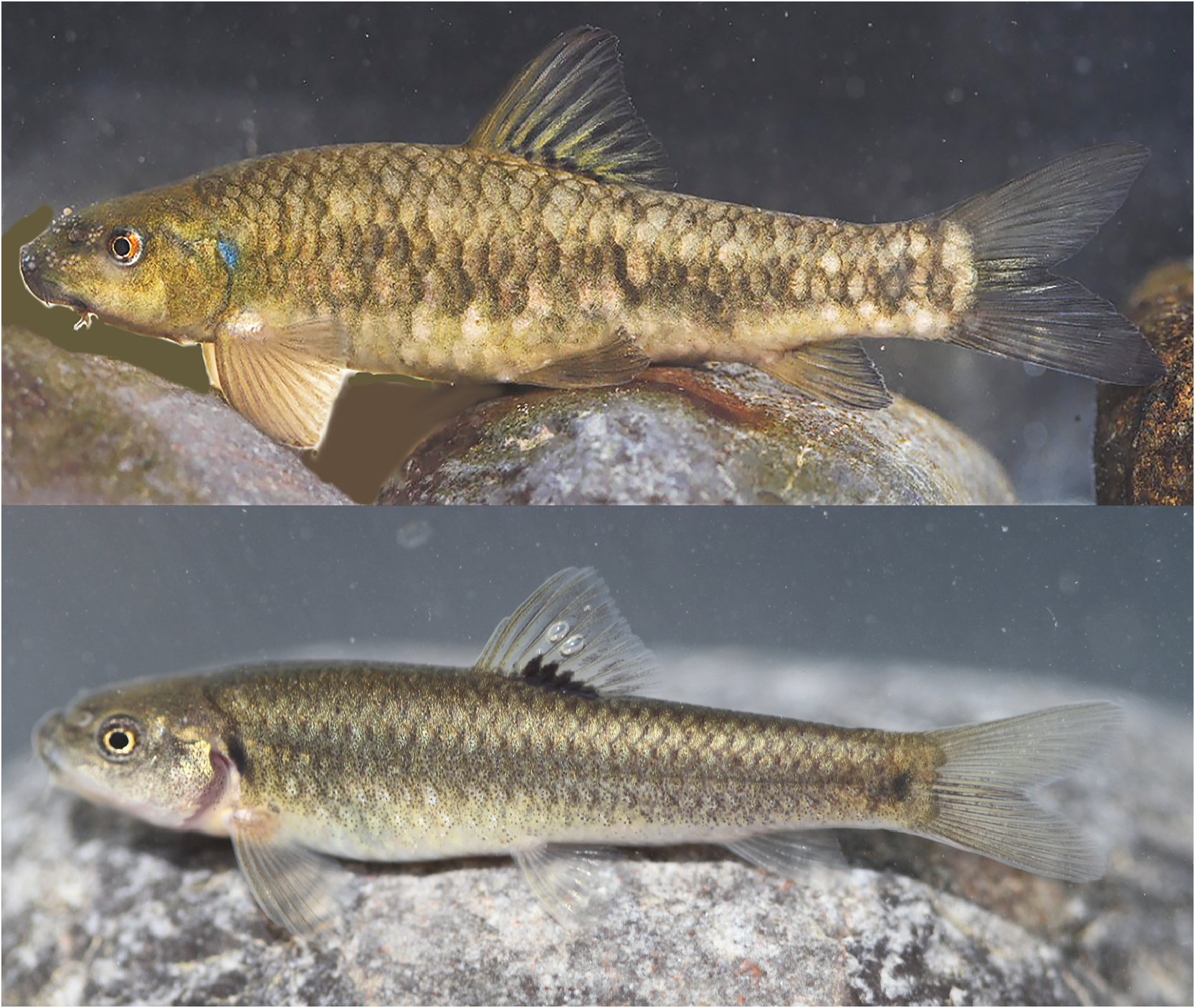
6. Garra longipinnis Banister & Clarke, 1977 View in CoL , Endemic
Fig. 20 View FIGURE 20
Etymology: Garra : named based on a vernacular Indian name, a fish living in mud; longipinnis: Latin , longus for long, and pinna for fin.
Common name: Jabal Akhdar Garra .
Taxonomy: Garra longipinnis was described by Banister [K. E.] & Clarke [M. A.] 1977:137, fig. 23 [Journal Oman Studies (Special Report)] from Saiq, Jabal al Akhdar, 23°02’N, 57°28’E, Oman.
Holotype: BMNH 1968.10.11. 1 . Paratypes: BMNH 1968.10.11.2-8 (7) .
Short description: Garra longipinnis is distinguished from G. barreimiae by having a greenish-brown or grey flank without or with slight mottling (vs. strongly mottled), a faint lateral stripe present in some individuals (vs. absent), orange midlateral scales on the flank absent (vs. present), orange spot at the upper opercle absent (vs. present), dorsal-fin tip not white (vs. white), and 12–14 gill rakers on lower limb of first gill arch (vs. 15–18). Garra longipinnis differs from G. gallagheri by having a bold, dark-brown or grey scale pockets on the dorsal surface, and dark-brown or grey scale margins on the flank which are clearly darker than the centre of the scales (vs. scale pockets and scale margins same colour as or only slightly darker than centre of scales).
Distribution: Southern Hajar Mountains, Wadi Dhum, Wadi Falahi, Hoti Pit, Lizq, Ain Wadhah, Bahla, Ad Dakhiliyah Governorate; Hoota Cave, Al Hamra, Ad Dakhiliyah Governorate; Tanuf, Nizwa, Ad Dakhiliyah Governorate; Wadi Andam, Al Wusta Governorate; Saiq, Oman ( Fig. 21 View FIGURE 21 ).
Examined material: ZM-CBSU: O007. Gl 101, 29, Oman: Hoota Cave, 23°04’55”N, 57°21’16”E, S.M. Al-Jufaili, Nov. 2020 GoogleMaps . ZM-CBSU: O008. Gl 1, 10, Oman: Wadi Andam, 22°47’22”N, 58°00’00”E, S.M. Al-Jufaili, Nov. 2020 GoogleMaps .

No known copyright restrictions apply. See Agosti, D., Egloff, W., 2009. Taxonomic information exchange and copyright: the Plazi approach. BMC Research Notes 2009, 2:53 for further explanation.
|
Kingdom |
|
|
Phylum |
|
|
Class |
|
|
Order |
|
|
Family |
|
|
Genus |