Arbon, Idaho
Submit your own pictures of this place and show them to the world
- OSM Map
- General Map
- Google Map
- MSN Map

| Males: 98 | |
| Females: 79 |
| Median resident age: | 36.8 years |
| Idaho median age: | 33.2 years |
Zip code: 83212
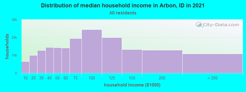
| Arbon: | $57,537 |
| ID: | $72,785 |
Estimated per capita income in 2022: $23,954 (it was $13,529 in 2000)
Estimated median house or condo value in 2022: $262,906 (it was $95,000 in 2000)
| Arbon: | $262,906 |
| ID: | $432,500 |
Detailed information about poverty and poor residents in Arbon, ID


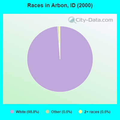
- 17198.8%White alone
- 10.6%Other race alone
- 10.6%Two or more races
 Recent articles from our blog. Our writers, many of them Ph.D. graduates or candidates, create easy-to-read articles on a wide variety of topics.
Current Local Time: MST time zone
Elevation: 5165 feet
Land area: 239.7 square miles.
Population density: 0.7 people per square mile (very low).

| Arbon CCD: | 0.5% ($500) |
| Idaho: | 1.0% ($1,007) |
Nearest city with pop. 50,000+: Pocatello, ID  (17.1 miles , pop. 51,466).
Nearest city with pop. 200,000+: Northeast Jefferson, CO (433.8 miles , pop. 450,166).
Nearest city with pop. 1,000,000+: Phoenix, AZ (630.1 miles , pop. 1,321,045).
Nearest cities:
), ), ), Latitude: 42.63 N, Longitude: 112.51 W
Area code: 208

| Here: | 4.2% |
| Idaho: | 3.1% |
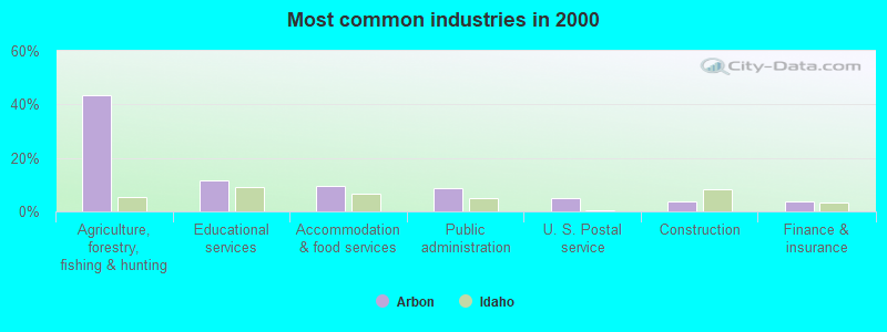
- Agriculture, forestry, fishing & hunting (43.3%)
- Educational services (11.5%)
- Accommodation & food services (9.6%)
- Public administration (8.7%)
- U. S. Postal service (4.8%)
- Construction (3.8%)
- Finance & insurance (3.8%)
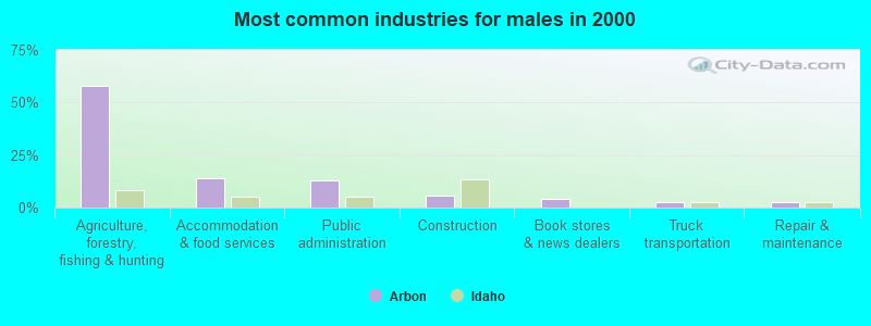
- Agriculture, forestry, fishing & hunting (57.7%)
- Accommodation & food services (14.1%)
- Public administration (12.7%)
- Construction (5.6%)
- Book stores & news dealers (4.2%)
- Truck transportation (2.8%)
- Repair & maintenance (2.8%)
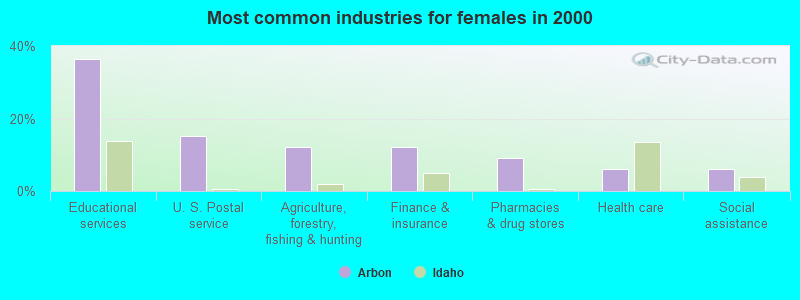
- Educational services (36.4%)
- U. S. Postal service (15.2%)
- Agriculture, forestry, fishing & hunting (12.1%)
- Finance & insurance (12.1%)
- Pharmacies & drug stores (9.1%)
- Health care (6.1%)
- Social assistance (6.1%)
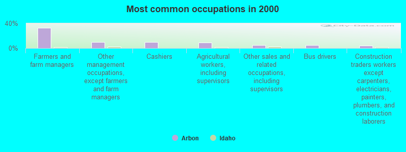
- Farmers and farm managers (32.7%)
- Other management occupations, except farmers and farm managers (9.6%)
- Cashiers (9.6%)
- Agricultural workers, including supervisors (8.7%)
- Other sales and related occupations, including supervisors (4.8%)
- Bus drivers (4.8%)
- Construction traders workers except carpenters, electricians, painters, plumbers, and construction laborers (3.8%)
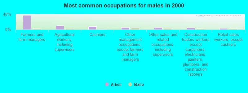
- Farmers and farm managers (45.1%)
- Agricultural workers, including supervisors (12.7%)
- Cashiers (9.9%)
- Other management occupations, except farmers and farm managers (7.0%)
- Other sales and related occupations, including supervisors (7.0%)
- Construction traders workers except carpenters, electricians, painters, plumbers, and construction laborers (5.6%)
- Retail sales workers, except cashiers (4.2%)
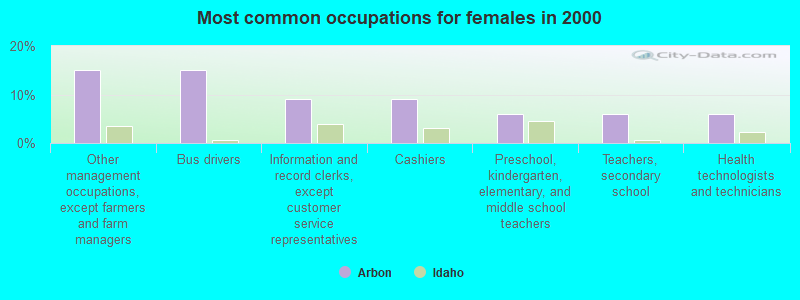
- Other management occupations, except farmers and farm managers (15.2%)
- Bus drivers (15.2%)
- Information and record clerks, except customer service representatives (9.1%)
- Cashiers (9.1%)
- Preschool, kindergarten, elementary, and middle school teachers (6.1%)
- Teachers, secondary school (6.1%)
- Health technologists and technicians (6.1%)
Average climate in Arbon, Idaho
Based on data reported by over 4,000 weather stations


(lower is better)
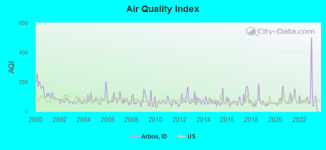
Air Quality Index (AQI) level in 2022 was 78.5. This is about average.
| City: | 78.5 |
| U.S.: | 72.6 |
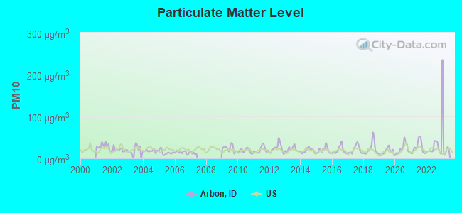
Particulate Matter (PM10) [µg/m3] level in 2022 was 23.0. This is about average. Closest monitor was 16.4 miles away from the city center.
| City: | 23.0 |
| U.S.: | 19.2 |
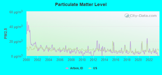
Particulate Matter (PM2.5) [µg/m3] level in 2022 was 6.06. This is better than average. Closest monitor was 17.1 miles away from the city center.
| City: | 6.06 |
| U.S.: | 8.11 |
Earthquake activity:
Arbon-area historical earthquake activity is significantly above Idaho state average. It is 1940% greater than the overall U.S. average.On 8/18/1959 at 06:37:13, a magnitude 7.7 (7.7 UK, Class: Major, Intensity: VIII - XII) earthquake occurred 162.9 miles away from the city center, causing $26,000,000 total damage
On 10/28/1983 at 14:06:06, a magnitude 7.3 (6.2 MB, 7.3 MS, 7.0 MW) earthquake occurred 119.1 miles away from Arbon center, causing 2 deaths (2 shaking deaths) and 3 injuries, causing $15,000,000 total damage
On 10/3/1915 at 06:52:48, a magnitude 7.6 (7.6 UK) earthquake occurred 297.2 miles away from the city center
On 3/28/1975 at 02:31:05, a magnitude 6.2 (6.1 MB, 6.0 MS, 6.2 ML, Class: Strong, Intensity: VII - IX) earthquake occurred 43.0 miles away from the city center
On 3/31/2020 at 23:52:30, a magnitude 6.5 (6.5 MW, Depth: 7.5 mi) earthquake occurred 182.0 miles away from Arbon center
On 2/3/1994 at 09:05:04, a magnitude 5.8 (5.4 MB, 5.5 MS, 5.8 MW, 5.8 ML, Depth: 4.9 mi, Class: Moderate, Intensity: VI - VII) earthquake occurred 79.3 miles away from the city center
Magnitude types: body-wave magnitude (MB), local magnitude (ML), surface-wave magnitude (MS), moment magnitude (MW)
Natural disasters:
The number of natural disasters in Power County (4) is a lot smaller than the US average (15).Major Disasters (Presidential) Declared: 2
Emergencies Declared: 1
Causes of natural disasters: Fire: 1, Flood: 1, Heavy Rain: 1, Hurricane: 1, Other: 1 (Note: some incidents may be assigned to more than one category).
Colleges/universities with over 2000 students nearest to Arbon:
- Idaho State University (about 17 miles; Pocatello, ID; Full-time enrollment: 10,350)
- Utah State University (about 72 miles; Logan, UT; FT enrollment: 21,131)
- Brigham Young University-Idaho (about 90 miles; Rexburg, ID; FT enrollment: 30,522)
- College of Southern Idaho (about 100 miles; Twin Falls, ID; FT enrollment: 5,051)
- Weber State University (about 104 miles; Ogden, UT; FT enrollment: 17,655)
- Latter-day Saints Business College (about 133 miles; Salt Lake City, UT; FT enrollment: 2,059)
- University of Utah (about 134 miles; Salt Lake City, UT; FT enrollment: 28,454)
Public elementary/middle school in Arbon:
- ARBON ELEMENTARY SCHOOL (Students: 9, Location: 4405 ARBON VALLEY HWY, Grades: KG-6)
Points of interest:
Notable location: Elkhead Ranch (A). Display/hide its location on the map
Reservoir: Upper Stump Canyon Reservoir (A). Display/hide its location on the map
Creeks: Knox Creek (A), Short Creek (B), Little Midnight Creek (C), Clifton Creek (D). Display/hide their locations on the map
| This place: | 2.4 people |
| Idaho: | 2.7 people |
| This place: | 76.0% |
| Whole state: | 69.6% |
| This place: | 0.0% |
| Whole state: | 6.3% |
No gay or lesbian households reported
| This place: | 15.1% |
| Whole state: | 11.8% |
| This place: | 8.6% |
| Whole state: | 4.6% |
For population 15 years and over in Arbon:
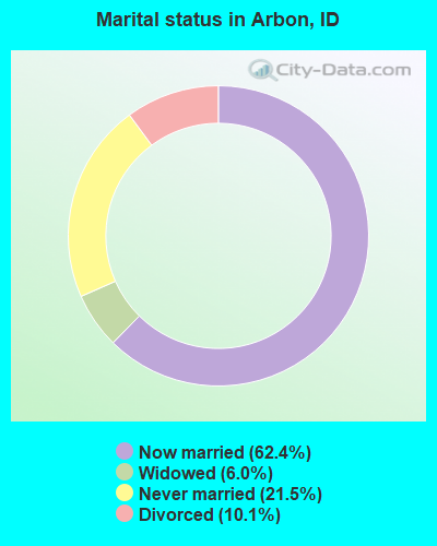
- Never married: 21.5%
- Now married: 62.4%
- Separated: 0.0%
- Widowed: 6.0%
- Divorced: 10.1%
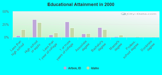
For population 25 years and over in Arbon:
- High school or higher: 96.7%
- Bachelor's degree or higher: 20.5%
- Graduate or professional degree: 1.6%
- Unemployed: 1.9%
- Mean travel time to work (commute): 15.2 minutes

| Here: | 6.9 |
| Idaho average: | 11.1 |
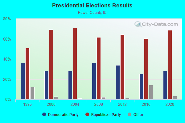
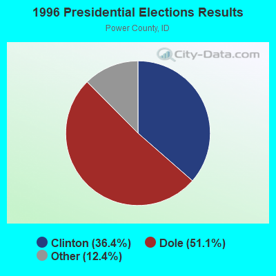

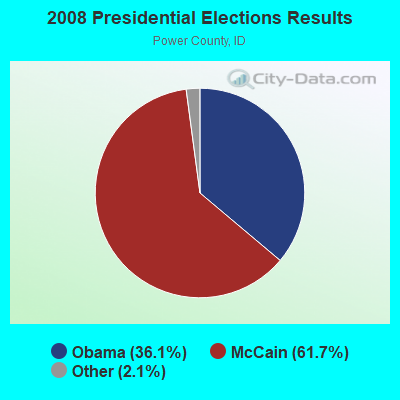
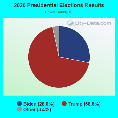
Graphs represent county-level data. Detailed 2008 Election Results
Religion statistics for Arbon, ID (based on Power County data)
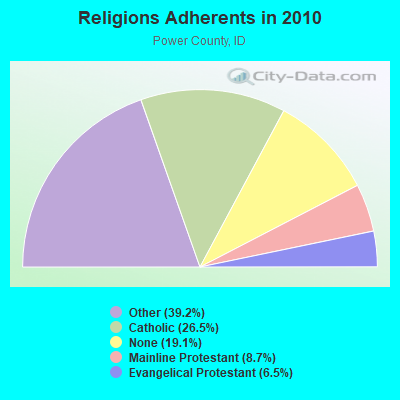
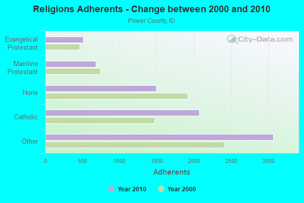
| Religion | Adherents | Congregations |
|---|---|---|
| Other | 3,066 | 9 |
| Catholic | 2,072 | 2 |
| Mainline Protestant | 681 | 3 |
| Evangelical Protestant | 508 | 7 |
| None | 1,490 | - |
Food Environment Statistics:
| Power County: | 2.62 / 10,000 pop. |
| Idaho: | 1.88 / 10,000 pop. |
| Power County: | 1.31 / 10,000 pop. |
| Idaho: | 0.53 / 10,000 pop. |
| Power County: | 1.31 / 10,000 pop. |
| State: | 3.87 / 10,000 pop. |
| Here: | 9.15 / 10,000 pop. |
| State: | 7.75 / 10,000 pop. |
| This county: | 7.3% |
| Idaho: | 7.7% |
| Power County: | 28.8% |
| Idaho: | 25.7% |
| This county: | 18.2% |
| State: | 11.7% |
Strongest AM radio stations in Arbon:
- KSEI (930 AM; 5 kW; POCATELLO, ID; Owner: PACIFIC EMPIRE COMMUNICATIONS CORP.)
- KZNR (690 AM; 10 kW; BLACKFOOT, ID; Owner: WESTERN COMMUNICATIONS, INC.)
- KBLI (1620 AM; 10 kW; BLACKFOOT, ID; Owner: WESTERN COMMUNICATIONS, INC.)
- KALL (700 AM; 50 kW; NORTH SALT LAKE CITY, UT; Owner: CITICASTERS LICENSES, L.P.)
- KBRV (790 AM; 5 kW; SODA SPRINGS, ID; Owner: CARIBOU BROADCASTING INC.)
- KIQN (1010 AM; 50 kW; TOOELE, UT)
- KSL (1160 AM; 50 kW; SALT LAKE CITY, UT; Owner: BONNEVILLE HOLDING COMPANY)
- KWIK (1240 AM; 1 kW; POCATELLO, ID; Owner: CITICASTERS LICENSES, L.P.)
- KSOS (800 AM; 10 kW; BRIGHAM CITY, UT; Owner: SIMMONS-SLC, LS, LLC)
- KBOI (670 AM; 50 kW; BOISE, ID; Owner: CITADEL BROADCASTING COMPANY)
- KRTK (1490 AM; 1 kW; CHUBBUCK, ID; Owner: BROKEN CHAINS INC.)
- KID (590 AM; 5 kW; IDAHO FALLS, ID; Owner: CITICASTERS LICENSES, L.P.)
- KOUU (1290 AM; 1 kW; POCATELLO, ID; Owner: IDAHO WIRELESS CORPORATION)
Strongest FM radio stations in Arbon:
- K299AH (107.7 FM; POCATELLO, ID; Owner: UNIVERSITY OF UTAH)
- KISU-FM (91.1 FM; POCATELLO, ID; Owner: IDAHO STATE UNIVERSITY)
- KMGI (102.5 FM; POCATELLO, ID; Owner: PACIFIC EMPIRE COMMUNICATIONS CORP.)
- KORR (104.1 FM; AMERICAN FALLS, ID; Owner: IDAHO WIRELESS CORPORATION)
- KZBQ (93.7 FM; POCATELLO, ID; Owner: IDAHO WIRELESS CORPORATION)
- KPKY (94.9 FM; POCATELLO, ID; Owner: CITICASTERS LICENSES, L.P.)
- KLLP (98.5 FM; CHUBBUCK, ID; Owner: CITICASTERS LICENSES, L.P.)
- K249CM (97.7 FM; POCATELLO, ID; Owner: WESTERN COMMUNICATIONS, INC.)
- K266AF (101.1 FM; POCATELLO, ID; Owner: WESTERN COMMUNICATIONS, INC.)
- KCIR (90.7 FM; TWIN FALLS, ID; Owner: FAITH COMMUNICATIONS CORP)
- KBSY (88.5 FM; BURLEY, ID; Owner: IDAHO STATE BOARD OF EDUCATION)
- KKMV (92.5 FM; RUPERT, ID; Owner: TRI-MARKET RADIO BROADCASTERS, INC.)
- KZDX (99.9 FM; BURLEY, ID; Owner: KART & EAGLE ROCK B/C INC,TENANTS)
- KRAR (106.9 FM; BRIGHAM CITY, UT; Owner: MERCURY BROADCASTING COMPANY, INC.)
- KJQN (100.7 FM; BRIGHAM CITY, UT; Owner: SIMMONS-SLC, LS, LLC)
TV broadcast stations around Arbon:
- K59BV (Channel 59; LAVA HOT SPRINGS, ID; Owner: STATE BOARD OF EDUCATION (IEPBS))
- KPVI (Channel 6; POCATELLO, ID; Owner: OREGON TRAIL BROADCASTING COMPANY)
- KFXP (Channel 31; POCATELLO, ID; Owner: COMPASS COMMUNICATION OF IDAHO, INC.)
- K12OA (Channel 12; POCATELLO, ID; Owner: OREGON TRAIL BROADCASTING COMPANY)
FCC Registered Broadcast Land Mobile Towers:
1- Hwy 68 10 Mi S Pauline (Lat: 42.427694 Lon: -112.556361), Call Sign: KNHP588,
Assigned Frequencies: 153.005 MHz, Grant Date: 10/19/2023, Expiration Date: 10/06/2033, Registrant: Ward & Sons Company Inc., 5336 Arbon Valley Hwy, Arbon, ID 83212, Phone: (208) 335-2263, Email:
FCC Registered Amateur Radio Licenses:
1- Call Sign: KE7YOL, Licensee ID: L01449185, Grant Date: 10/23/2018, Expiration Date: 12/01/2028, Certifier: Benjamin R Hall, Registrant: Benjamin R Hall, 1170 Lusk Loop, Arbon, ID 83212
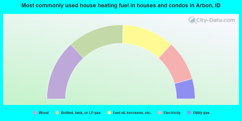
- 26.3%Wood
- 24.6%Bottled, tank, or LP gas
- 22.8%Fuel oil, kerosene, etc.
- 17.5%Electricity
- 8.8%Utility gas
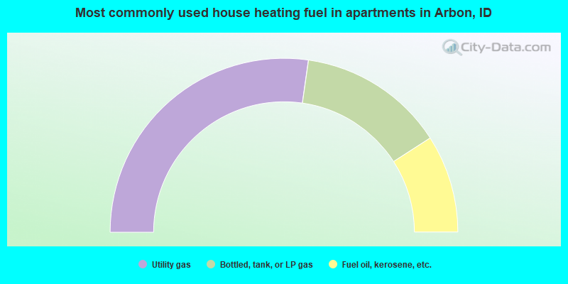
- 54.5%Utility gas
- 27.3%Bottled, tank, or LP gas
- 18.2%Fuel oil, kerosene, etc.
Arbon compared to Idaho state average:
- Median house value below state average.
- Unemployed percentage significantly below state average.
- Black race population percentage significantly below state average.
- Hispanic race population percentage significantly below state average.
- Median age below state average.
- Foreign-born population percentage significantly below state average.
- Renting percentage below state average.
- Length of stay since moving in significantly above state average.
- Number of rooms per house significantly below state average.
- House age significantly below state average.