Plainfield, Massachusetts
Submit your own pictures of this town and show them to the world
- OSM Map
- General Map
- Google Map
- MSN Map
Population change since 2000: +10.0%
 |
| Males: 322 | |
| Females: 326 |
| Median resident age: | 48.3 years |
| Massachusetts median age: | 39.2 years |
Zip codes: 01070.
| Plainfield: | $66,324 |
| MA: | $94,488 |
Estimated per capita income in 2022: $39,869 (it was $20,785 in 2000)
Plainfield town income, earnings, and wages data
Estimated median house or condo value in 2022: $360,724 (it was $138,800 in 2000)
| Plainfield: | $360,724 |
| MA: | $534,700 |
Mean prices in 2022: all housing units: $406,762; detached houses: $418,541; townhouses or other attached units: $363,334; in 2-unit structures: $269,911; in 3-to-4-unit structures: $561,325; in 5-or-more-unit structures: $236,751; mobile homes: $362,036
Detailed information about poverty and poor residents in Plainfield, MA


- 61795.2%White alone
- 142.2%Black alone
- 91.4%Hispanic
- 40.6%Asian alone
- 30.5%Two or more races
- 10.2%American Indian alone
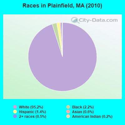
Races in Plainfield detailed stats: ancestries, foreign born residents, place of birth
According to our research of Massachusetts and other state lists, there was 1 registered sex offender living in Plainfield, Massachusetts as of May 01, 2024.
The ratio of all residents to sex offenders in Plainfield is 648 to 1.
 Recent articles from our blog. Our writers, many of them Ph.D. graduates or candidates, create easy-to-read articles on a wide variety of topics.

 | The worst winter in Massachusetts. Is the weather bothering you? (285 replies) |
| Is Massachusetts really just as expensive as NJ? (57 replies) |
| How Much Massachusetts Households Make Per Year: Census Data (37 replies) |
| Is Boston really part of the Northeast Corridor? (111 replies) |
| Most popular town names in New England (11 replies) |
| Massachusetts Hilltowns (17 replies) |
Latest news from Plainfield, MA collected exclusively by city-data.com from local newspapers, TV, and radio stations
Ancestries: English (19.5%), Irish (15.1%), German (12.2%), French (11.0%), Italian (10.7%), French Canadian (10.0%).
Current Local Time: EST time zone
Incorporated in 1807
Land area: 21.1 square miles.
Population density: 31 people per square mile (very low).
23 residents are foreign born (1.7% Europe, 1.5% North America).
| This town: | 3.9% |
| Massachusetts: | 12.2% |
| Plainfield town: | 1.1% ($1,548) |
| Massachusetts: | 1.3% ($2,336) |
Nearest city with pop. 50,000+: Chicopee, MA  (29.2 miles , pop. 54,653).
Nearest city with pop. 200,000+: Boston, MA (94.4 miles , pop. 589,141).
Nearest city with pop. 1,000,000+: Bronx, NY (125.4 miles , pop. 1,332,650).
Nearest cities:
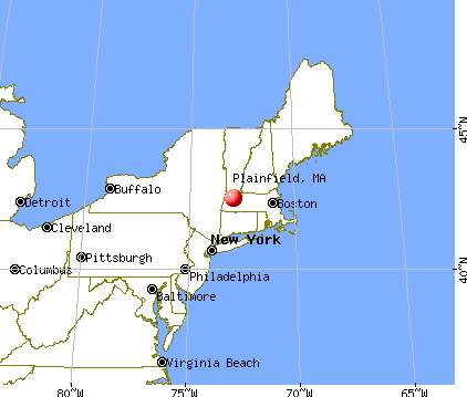
), ), ), ), ), ), )Latitude: 42.51 N, Longitude: 72.92 W
Area code commonly used in this area: 413


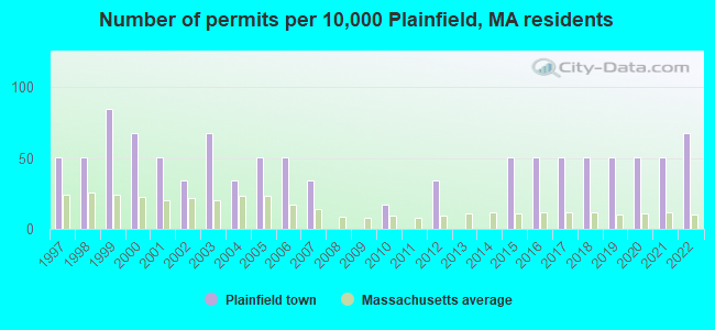
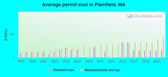
Single-family new house construction building permits:
- 2022: 4 buildings, average cost: $156,000
- 2021: 3 buildings, average cost: $156,000
- 2020: 3 buildings, average cost: $156,000
- 2019: 3 buildings, average cost: $156,000
- 2018: 3 buildings, average cost: $156,000
- 2017: 3 buildings, average cost: $156,000
- 2016: 3 buildings, average cost: $332,000
- 2015: 3 buildings, average cost: $332,000
- 2012: 2 buildings, average cost: $131,000
- 2010: 1 building, cost: $220,000
- 2007: 2 buildings, average cost: $170,000
- 2006: 3 buildings, average cost: $170,000
- 2005: 3 buildings, average cost: $214,000
- 2004: 2 buildings, average cost: $175,000
- 2003: 4 buildings, average cost: $125,800
- 2002: 2 buildings, average cost: $67,500
- 2001: 3 buildings, average cost: $120,700
- 2000: 4 buildings, average cost: $113,800
- 1999: 5 buildings, average cost: $117,600
- 1998: 3 buildings, average cost: $127,300
- 1997: 3 buildings, average cost: $100,000
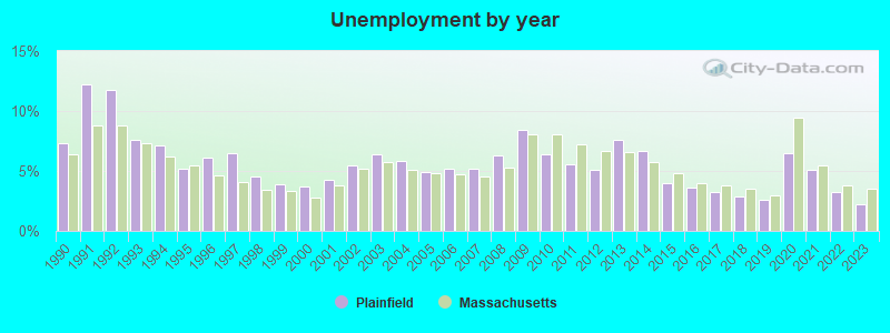
| Here: | 2.2% |
| Massachusetts: | 3.5% |
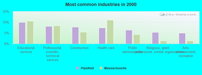
- Educational services (10.0%)
- Professional, scientific, technical services (8.2%)
- Construction (7.8%)
- Health care (7.5%)
- Public administration (6.4%)
- Religious, grantmaking, civic, professional, similar organizations (5.3%)
- Arts, entertainment, recreation (5.0%)
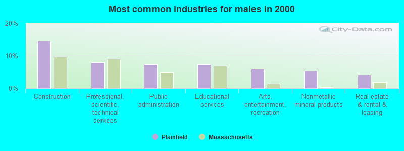
- Construction (14.6%)
- Professional, scientific, technical services (7.9%)
- Public administration (7.3%)
- Educational services (7.3%)
- Arts, entertainment, recreation (6.0%)
- Nonmetallic mineral products (5.3%)
- Real estate & rental & leasing (4.0%)
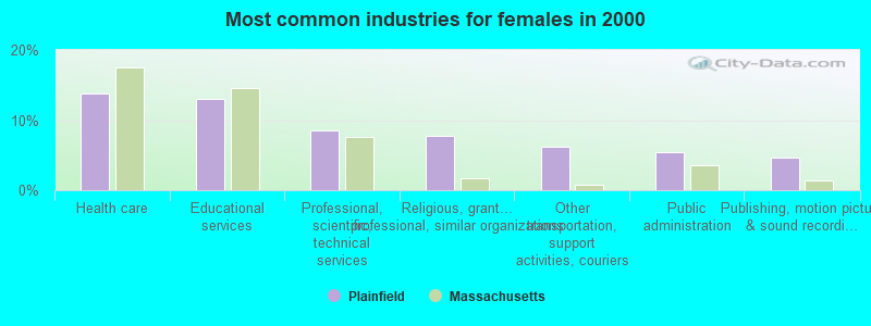
- Health care (13.8%)
- Educational services (13.1%)
- Professional, scientific, technical services (8.5%)
- Religious, grantmaking, civic, professional, similar organizations (7.7%)
- Other transportation, support activities, couriers (6.2%)
- Public administration (5.4%)
- Publishing, motion picture & sound recording industries (4.6%)

- Other management occupations, except farmers and farm managers (8.5%)
- Other sales and related occupations, including supervisors (8.5%)
- Other production occupations, including supervisors (8.2%)
- Top executives (5.0%)
- Vehicle and mobile equipment mechanics, installers, and repairers (4.3%)
- Driver/sales workers and truck drivers (3.9%)
- Entertainers and performers, sports, and related workers (3.6%)

- Other production occupations, including supervisors (11.3%)
- Vehicle and mobile equipment mechanics, installers, and repairers (7.9%)
- Top executives (7.3%)
- Driver/sales workers and truck drivers (7.3%)
- Supervisors, construction and extraction workers (6.0%)
- Other sales and related occupations, including supervisors (4.6%)
- Other management occupations, except farmers and farm managers (4.0%)

- Other management occupations, except farmers and farm managers (13.8%)
- Other sales and related occupations, including supervisors (13.1%)
- Registered nurses (7.7%)
- Information and record clerks, except customer service representatives (6.9%)
- Other teachers, instructors, education, training, and library occupations (6.2%)
- Bus drivers (6.2%)
- Other production occupations, including supervisors (4.6%)
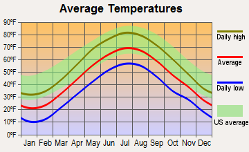
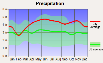
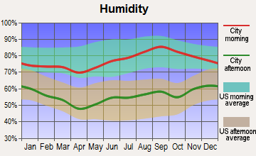
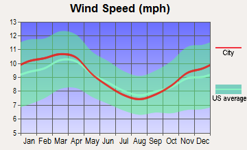
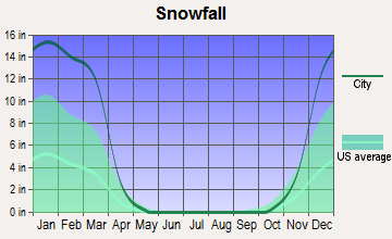
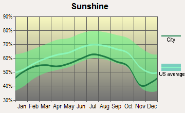
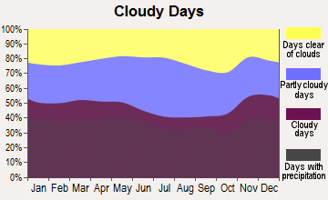
Average climate in Plainfield, Massachusetts
Based on data reported by over 4,000 weather stations
(lower is better)
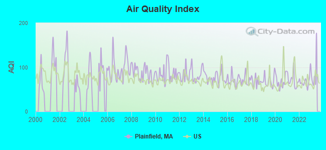
Air Quality Index (AQI) level in 2022 was 69.0. This is about average.
| City: | 69.0 |
| U.S.: | 72.6 |
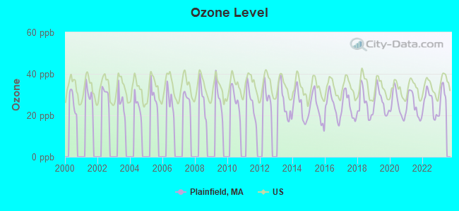
Ozone [ppb] level in 2022 was 25.7. This is better than average. Closest monitor was 14.9 miles away from the city center.
| City: | 25.7 |
| U.S.: | 33.3 |
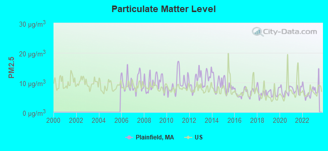
Particulate Matter (PM2.5) [µg/m3] level in 2022 was 6.57. This is better than average. Closest monitor was 16.3 miles away from the city center.
| City: | 6.57 |
| U.S.: | 8.11 |
Tornado activity:
Plainfield-area historical tornado activity is slightly above Massachusetts state average. It is 16% smaller than the overall U.S. average.
On 8/28/1973, a category F4 (max. wind speeds 207-260 mph) tornado 26.3 miles away from the Plainfield town center killed 4 people and injured 36 people and caused between $5,000,000 and $50,000,000 in damages.
On 5/29/1995, a category F4 tornado 27.0 miles away from the town center killed 3 people and injured 24 people and caused between $5,000,000 and $50,000,000 in damages.
Earthquake activity:
Plainfield-area historical earthquake activity is significantly above Massachusetts state average. It is 69% smaller than the overall U.S. average.On 10/7/1983 at 10:18:46, a magnitude 5.3 (5.1 MB, 5.3 LG, 5.1 ML, Class: Moderate, Intensity: VI - VII) earthquake occurred 122.7 miles away from Plainfield center
On 4/20/2002 at 10:50:47, a magnitude 5.3 (5.3 ML, Depth: 3.0 mi) earthquake occurred 143.7 miles away from the city center
On 4/20/2002 at 10:50:47, a magnitude 5.2 (5.2 MB, 4.2 MS, 5.2 MW, 5.0 MW) earthquake occurred 142.3 miles away from the city center
On 1/19/1982 at 00:14:42, a magnitude 4.7 (4.5 MB, 4.7 MD, 4.5 LG, Class: Light, Intensity: IV - V) earthquake occurred 95.4 miles away from the city center
On 10/16/2012 at 23:12:25, a magnitude 4.7 (4.7 ML, Depth: 10.0 mi) earthquake occurred 136.8 miles away from Plainfield center
On 6/17/1991 at 08:53:16, a magnitude 4.1 (4.0 MB, 4.0 LG, Depth: 3.1 mi) earthquake occurred 89.9 miles away from the city center
Magnitude types: regional Lg-wave magnitude (LG), body-wave magnitude (MB), duration magnitude (MD), local magnitude (ML), surface-wave magnitude (MS), moment magnitude (MW)
Natural disasters:
The number of natural disasters in Hampshire County (21) is greater than the US average (15).Major Disasters (Presidential) Declared: 10
Emergencies Declared: 10
Causes of natural disasters: Floods: 5, Snowstorms: 5, Storms: 5, Hurricanes: 4, Winter Storms: 4, Blizzards: 2, Snows: 2, Snowfall: 1, Tropical Storm: 1, Wind: 1, Other: 1 (Note: some incidents may be assigned to more than one category).
Hospitals and medical centers near Plainfield:
- ANCHORAGE NURSING HOME (Nursing Home, about 14 miles away; SHELBURNE, MA)
- NORTHERN BERKSHIRE COMPREHENSIVE CARE (Home Health Center, about 14 miles away; ADAMS, MA)
- HOSPICE OF N BERKSHIRE INC (Hospital, about 14 miles away; ADAMS, MA)
- CRANEVILLE PLACE AT DALTON (Nursing Home, about 14 miles away; DALTON, MA)
- OVERLOOK AT NORTHAMPTON (Nursing Home, about 16 miles away; LEEDS, MA)
- LINDA MANOR EXTENDED CARE FACILITY (Nursing Home, about 16 miles away; LEEDS, MA)
Colleges/universities with over 2000 students nearest to Plainfield:
- Smith College (about 20 miles; Northampton, MA; Full-time enrollment: 3,549)
- Williams College (about 21 miles; Williamstown, MA; FT enrollment: 2,141)
- University of Massachusetts-Amherst (about 22 miles; Amherst, MA; FT enrollment: 26,583)
- Mount Holyoke College (about 26 miles; South Hadley, MA; FT enrollment: 2,573)
- Holyoke Community College (about 26 miles; Holyoke, MA; FT enrollment: 4,911)
- Westfield State University (about 28 miles; Westfield, MA; FT enrollment: 5,548)
- Springfield Technical Community College (about 33 miles; Springfield, MA; FT enrollment: 4,750)
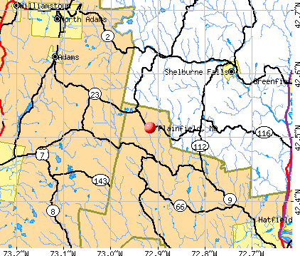
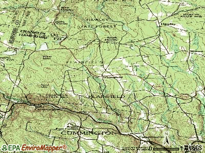
Points of interest:
Notable locations in Plainfield: Plainfield Town Hall (A), Plainfield Fire EMS (B), Plainfield Fire Department (C), Shaw Memorial Library (D). Display/hide their locations on the map
Cemetery: Allis Cemetery (1). Display/hide its location on the map
Lakes and reservoirs: Plainfield Pond (A), Gun Club Pond (B), Crooked Pond (C), Hallockville Pond (D). Display/hide their locations on the map
Park in Plainfield: Deer Hill State Reservation (1). Display/hide its location on the map
Hotel: Hill Top Colonial Inn (788 West Main Street) (1). Display/hide its approximate location on the map
Birthplace of: William Richards (Hawaii) - Translator.
| This town: | 2.4 people |
| Massachusetts: | 2.5 people |
| This town: | 63.9% |
| Whole state: | 63.0% |
| This town: | 11.5% |
| Whole state: | 7.0% |
Likely homosexual households (counted as self-reported same-sex unmarried-partner households)
- Lesbian couples: 0.4% of all households
- Gay men: 0.7% of all households
| This town: | 8.0% |
| Whole state: | 9.3% |
| This town: | 3.1% |
| Whole state: | 4.4% |
For population 15 years and over in Plainfield:
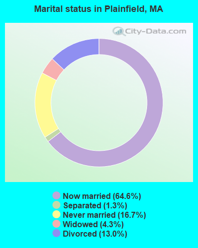
- Never married: 16.7%
- Now married: 64.6%
- Separated: 1.3%
- Widowed: 4.3%
- Divorced: 13.0%
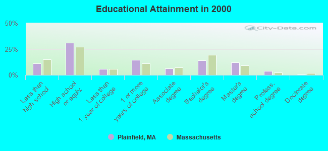
For population 25 years and over in Plainfield:
- High school or higher: 88.7%
- Bachelor's degree or higher: 30.8%
- Graduate or professional degree: 16.6%
- Unemployed: 1.4%
- Mean travel time to work (commute): 33.5 minutes
| Here: | 11.6 |
| Massachusetts average: | 13.1 |
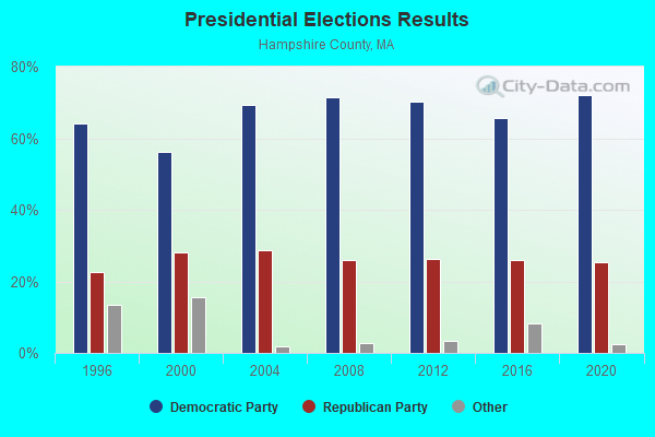
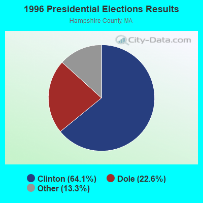
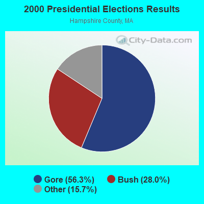
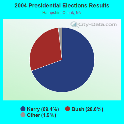
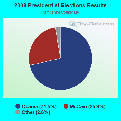
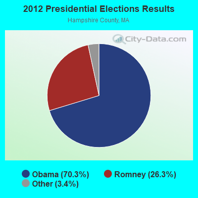

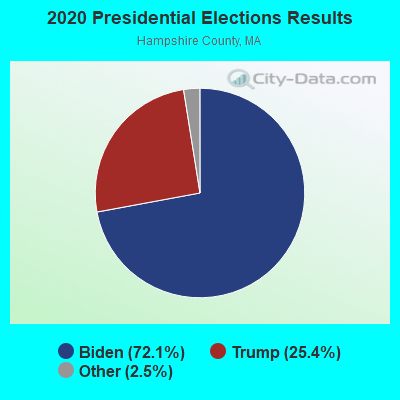
Graphs represent county-level data. Detailed 2008 Election Results
Religion statistics for Plainfield, MA (based on Hampshire County data)
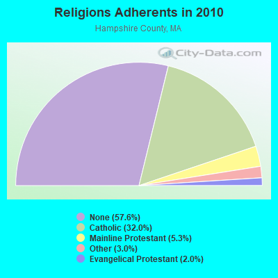
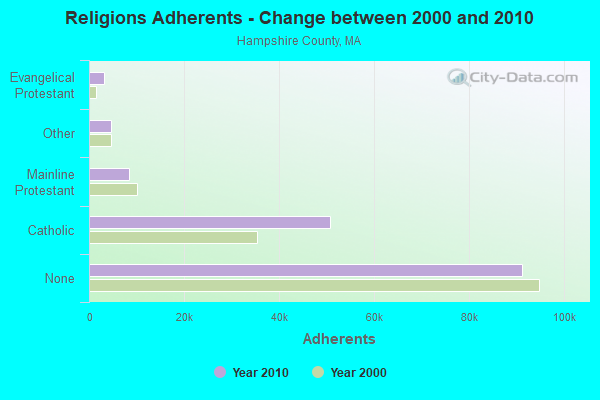
| Religion | Adherents | Congregations |
|---|---|---|
| Catholic | 50,643 | 22 |
| Mainline Protestant | 8,454 | 45 |
| Other | 4,722 | 27 |
| Evangelical Protestant | 3,128 | 22 |
| Black Protestant | 29 | 1 |
| None | 91,104 | - |
Food Environment Statistics:
| Hampshire County: | 2.07 / 10,000 pop. |
| Massachusetts: | 1.98 / 10,000 pop. |
| Hampshire County: | 0.06 / 10,000 pop. |
| State: | 0.05 / 10,000 pop. |
| This county: | 1.55 / 10,000 pop. |
| Massachusetts: | 2.22 / 10,000 pop. |
| Here: | 1.94 / 10,000 pop. |
| Massachusetts: | 1.77 / 10,000 pop. |
| This county: | 10.22 / 10,000 pop. |
| Massachusetts: | 8.76 / 10,000 pop. |
| Here: | 7.3% |
| Massachusetts: | 8.1% |
| This county: | 21.7% |
| Massachusetts: | 22.5% |
| This county: | 12.3% |
| Massachusetts: | 16.5% |
Strongest AM radio stations in Plainfield:
- WNNZ (640 AM; 50 kW; WESTFIELD, MA; Owner: CLEAR CHANNEL BROADCASTING LICENSES, INC.)
- WIZZ (1520 AM; daytime; 10 kW; GREENFIELD, MA; Owner: P. & M. RADIO, LLC)
- WCRN (830 AM; 50 kW; WORCESTER, MA; Owner: CARTER BROADCASTING CORPORATION)
- WTIC (1080 AM; 50 kW; HARTFORD, CT; Owner: INFINITY RADIO OPERATIONS INC.)
- WGY (810 AM; 50 kW; SCHENECTADY, NY; Owner: CLEAR CHANNEL BROADCASTING LICENSES, INC.)
- WVNE (760 AM; daytime; 25 kW; LEICESTER, MA; Owner: BLOUNT MASSCOM, INC.)
- WPTR (1540 AM; 50 kW; ALBANY, NY; Owner: KIMTRON, INC.)
- WHYN (560 AM; 5 kW; SPRINGFIELD, MA; Owner: CLEAR CHANNEL BROADCASTING LICENSES, INC.)
- WUHN (1110 AM; daytime; 5 kW; PITTSFIELD, MA; Owner: WEINER BROADCASTING, INC.)
- WRKO (680 AM; 50 kW; BOSTON, MA; Owner: ENTERCOM BOSTON LICENSE, LLC)
- WACE (730 AM; 5 kW; CHICOPEE, MA; Owner: CARTER BROADCASTING CORP.)
- WALE (990 AM; 50 kW; GREENVILLE, RI; Owner: NORTH AMERICAN BROADCASTING CO., INC.)
- WEEI (850 AM; 50 kW; BOSTON, MA; Owner: ENTERCOM BOSTON LICENSE, LLC)
Strongest FM radio stations in Plainfield:
- WAMC-FM (90.3 FM; ALBANY, NY; Owner: WAMC)
- WVAY (100.7 FM; WILMINGTON, VT; Owner: GREAT NORTHERN RADIO, L.L.C.)
- WEQX (102.7 FM; MANCHESTER, VT; Owner: NORTHSHIRE COMMUNICATIONS, INC.)
- WHYN-FM (93.1 FM; SPRINGFIELD, MA; Owner: CLEAR CHANNEL BROADCASTING LICENSES, INC.)
- WJAN (95.1 FM; SUNDERLAND, VT; Owner: 6 JOHNSON ROAD LICENSES, INC.)
- WPVQ (95.3 FM; GREENFIELD, MA; Owner: GREAT NORTHERN RADIO, L.L.C.)
- WMNB (100.1 FM; NORTH ADAMS, MA; Owner: BERKSHIRE BROADCASTING CO., INC.)
- WRNX (100.9 FM; AMHERST, MA; Owner: WESTERN MASSACHUSETTS RADIO COMPANY)
- WZEC (97.5 FM; HOOSICK FALLS, NY; Owner: GREAT NORTHERN RADIO, LLC)
- WFCR (88.5 FM; AMHERST, MA; Owner: UNIVERSITY OF MASSACHUSETTS)
- WHAI (98.3 FM; GREENFIELD, MA; Owner: SAGA COMMUNICATIONS OF NEW ENGLAND, LLC)
- WRSI (93.9 FM; TURNERS FALLS, MA; Owner: GREAT NORTHERN RADIO, LLC)
- WBEC-FM (105.5 FM; PITTSFIELD, MA; Owner: GREAT NORTHERN RADIO, LLC)
- WUPE (95.9 FM; PITTSFIELD, MA; Owner: WEINER BROADCASTING, INC.)
- WLZX (99.3 FM; NORTHAMPTON, MA; Owner: SAGA COMMUNICATIONS OF NEW ENGLAND, LLC)
- WHVP (91.1 FM; HUDSON, NY; Owner: SOUND OF LIFE, INC.)
- WRSY (101.5 FM; MARLBORO, VT; Owner: GREAT NORTHERN RADIO, L.L.C.)
- WAMH (89.3 FM; AMHERST, MA; Owner: TRUSTEES OF AMHERST COLLEGE)
- WAQY (102.1 FM; SPRINGFIELD, MA; Owner: SAGA COMMUNICATIONS OF NEW ENGLAND, LLC)
- W246AM (97.1 FM; AMHERST, MA; Owner: GREAT NORTHERN RADIO, LLC)
TV broadcast stations around Plainfield:
- W35BK (Channel 35; PLAINFIELD, MA; Owner: LYDIA SYLVANE STOCKWELL)
- WTIC-TV (Channel 61; HARTFORD, CT; Owner: TRIBUNE TELEVISION COMPANY)
- WYDN (Channel 48; WORCESTER, MA; Owner: EDUCATIONAL PUBLIC TV CORPORATION)
- WCDC-TV (Channel 19; ADAMS, MA; Owner: YOUNG BROADCASTING OF ALBANY, INC.)
- W38DL (Channel 38; ADAMS, ETC., MA; Owner: WNYT-TV, LLC)
Plainfield fatal accident list:
Oct 16, 1987 10:15 PM, S Central, Vehicles: 1, Persons: 1, Fatalities: 1
Jun 21, 1984 08:00 PM, 116, Vehicles: 1, Persons: 1, Fatalities: 1, Drunk persons involved: 1
Dec 7, 1976 02:15 AM, Vehicles: 1, Persons: 2, Fatalities: 1
Dec 7, 1975 02:15 AM, Vehicles: 1, Persons: 2, Fatalities: 1
- National Bridge Inventory (NBI) Statistics
- 2Number of bridges
- 10ft / 2.8mTotal length
- $3,946,000Total costs
- 258Total average daily traffic
- 10Total average daily truck traffic
- 1,343Total future (year 2032) average daily traffic
FCC Registered Broadcast Land Mobile Towers:
6- Fire Station Rt 116 (Lat: 42.524528 Lon: -72.912028), Type: Bant, Structure height: 9 m, Call Sign: WXT895,
Assigned Frequencies: 154.370 MHz, Grant Date: 03/04/2023, Expiration Date: 05/20/2033, Registrant: Plainnfield Fire Dept, 38 North Central St, Plainfield, MA 01070, Phone: (413) 427-0626, Email:
- 128 North Central Street (Lat: 42.525972 Lon: -72.914917), Type: Tower, Structure height: 35 m, Overall height: 59 m, Call Sign: WXY415,
Assigned Frequencies: 151.152 MHz, Grant Date: 03/04/2023, Expiration Date: 05/20/2033, Registrant: Plainnfield Fire Dept, 38 North Central St, Plainfield, MA 01070, Phone: (413) 427-0626, Email:
- Police Department, 315 Main Street (Lat: 42.516139 Lon: -72.913694), Type: Bant, Structure height: 13 m, Call Sign: WSL566, Licensee ID: L00031153,
Assigned Frequencies: 154.770 MHz, Grant Date: 10/10/2014, Expiration Date: 11/30/2024, Registrant: Plainfield, Town Of - Police
- Union St (Lat: 42.222028 Lon: -72.912889), Structure height: 12 m, Call Sign: WPDP975,
Assigned Frequencies: 48.1600 MHz, Grant Date: 12/06/2012, Expiration Date: 12/09/2022, Cancellation Date: 08/19/2015, Registrant: Keller And Heckman LLP, 1001 G Street Nw, Suite 500 West, Washington, DC 20001, Phone: (202) 434-4100, Fax: (202) 434-4646, Email:
- Plainfield, Hells Kitchen Road (Lat: 42.526028 Lon: -72.915000), Type: Ltower, Structure height: 45.7 m, Call Sign: WQGQ319,
Assigned Frequencies: 460.350 MHz, 460.400 MHz, Grant Date: 01/24/2017, Expiration Date: 03/21/2027, Certifier: Linda Dunlavy, Registrant: Franklin Regional Council Of Governments, 12 Olive St Ste 2, Greenfield, MA 01301-3351, Phone: (413) 774-3167, Fax: (413) 774-3169, Email:
- .3 Mi. North Of The Intersection Of N Union Street And N Central Ave (Lat: 42.526028 Lon: -72.915000), Type: Ltower, Structure height: 50.3 m, Overall height: 54.9 m, Call Sign: WQQY903,
Assigned Frequencies: 4965.00 MHz, Grant Date: 01/10/2023, Expiration Date: 03/28/2033, Certifier: Charles B Sutherland, Registrant: Commonwealth Of Massachusetts, Department Of State Police, 470 Worcester Rd, Framingham, MA 01702, Phone: (508) 820-2222, Fax: (774) 462-3768, Email:
FCC Registered Microwave Towers:
2- STATION, Union St (Lat: 42.522028 Lon: -72.912861), Overall height: 16.8 m, Call Sign: WNTT255,
Assigned Frequencies: 953.400 MHz, Grant Date: 02/12/2008, Expiration Date: 03/19/2018, Cancellation Date: 11/15/2010, Registrant: Northeast Utilities Service Company, Hartford, CT 06141-0270, Phone: (860) 665-3822, Fax: (860) 665-5585, Email:
- PLAINFIELD, Intersectikon Of Union St And N Central St (Lat: 42.526028 Lon: -72.915000), Type: Ltower, Structure height: 45.7 m, Call Sign: WQNC845,
Assigned Frequencies: 10775.0 MHz, 6004.50 MHz, 10558.1 MHz, Grant Date: 09/29/2020, Expiration Date: 12/21/2030, Certifier: Charles B Sutherland, Registrant: Massachusetts, Commonwealth Of, 470 Worcester Rd, Framingham, MA 01702, Phone: (508) 820-2264, Email:
FCC Registered Amateur Radio Licenses:
4- Call Sign: N1NYB, Licensee ID: L00577089, Grant Date: 11/08/2022, Expiration Date: 12/29/2032, Certifier: Ron J Stebbins, Registrant: Ronald J Stebbins, 785 West Main Street, Plainfield, MA 01070
- Call Sign: KB1ELM, Licensee ID: L00160273, Grant Date: 10/05/1999, Expiration Date: 10/05/2009, Cancellation Date: 01/07/2000, Certifier: Michael A Woolf, Registrant: Michael A Woolf, 8 Warner Hill Rd, Plainfield, MA 01070
- Call Sign: KB1FAQ, Licensee ID: L00227087, Grant Date: 04/13/2000, Expiration Date: 04/13/2010, Cancellation Date: 04/14/2012, Certifier: Leonard A Benoit, Registrant: Leonard A Benoit, 43 Campbell Rd, Plainfield, MA 01070
- Call Sign: W1NSD, Previous Call Sign: W6MXY, Licensee ID: L00278128, Grant Date: 08/29/2000, Expiration Date: 08/29/2010, Cancellation Date: 08/30/2012, Certifier: John O Copley, Registrant: John O Copley, 149 Pleasant St, Plainfield, MA 01070
FAA Registered Aircraft:
1- Aircraft: CESSNA 172A (Category: Land, Seats: 4, Weight: Up to 12,499 Pounds, Speed: 105 mph), Engine: CONT MOTOR 0-300 SER (145 HP) (Reciprocating)
N-Number: 7365T, N7365T, N-7365T, Serial Number: 46965, Year manufactured: 1959, Airworthiness Date: 10/27/1959, Certificate Issue Date: 04/03/2018
Registrant (Individual): David P Crowell, 54 S Central St, Plainfield, MA 01070
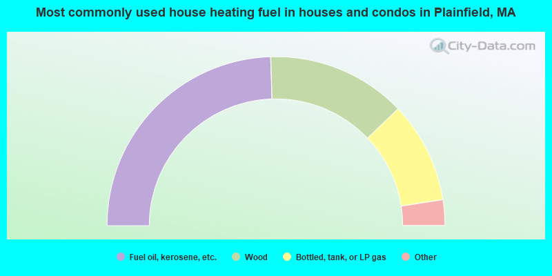
- 49.0%Fuel oil, kerosene, etc.
- 26.7%Wood
- 19.4%Bottled, tank, or LP gas
- 2.4%Electricity
- 1.5%Other fuel
- 1.0%No fuel used
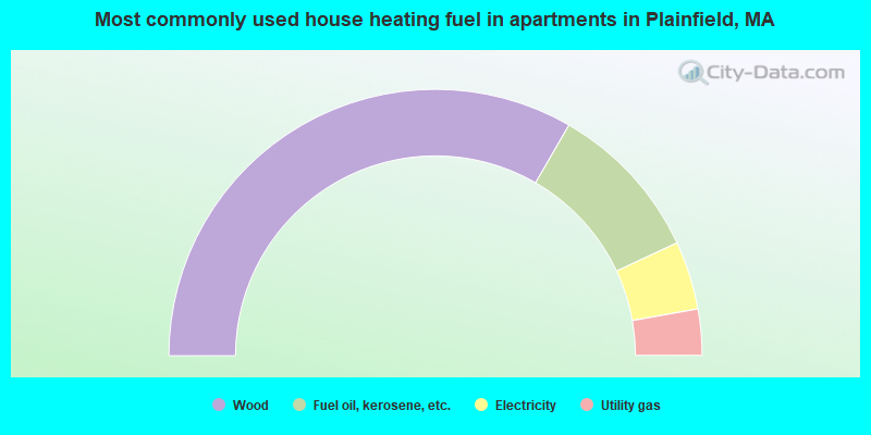
- 66.7%Wood
- 19.4%Fuel oil, kerosene, etc.
- 8.3%Electricity
- 5.6%Utility gas
Plainfield compared to Massachusetts state average:
- Unemployed percentage significantly below state average.
- Black race population percentage below state average.
- Hispanic race population percentage significantly below state average.
- Median age significantly above state average.
- Foreign-born population percentage significantly below state average.
- Renting percentage significantly below state average.
- Length of stay since moving in significantly above state average.
- Number of rooms per house significantly below state average.
- House age significantly below state average.

|
Total of 1 patent application in 2008-2024.