Chapter 1: Homesteads and railroads
We’ve had an opportunity in the last few months to take a deep dive into the history of the Sullivan’s Gulch neighborhood, which technically runs from NE Broadway to NE Holladay between NE 11th and NE 37th, sandwiched between the Holladay Park and Irvington neighborhoods to the north, and the Kerns neighborhood to the south. There are so many interesting chapters and stories to share about the Gulch, so we thought we’d capture some of them into a few posts.
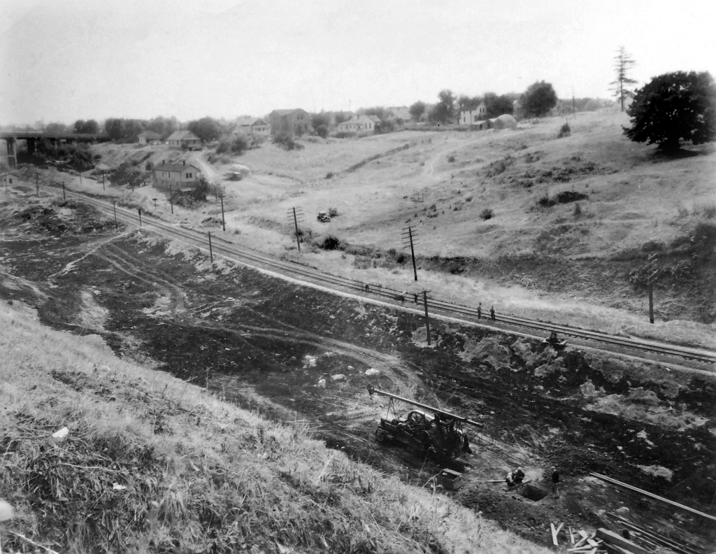
A scene from the Gulch in the 1920s, looking southeast directly toward the old Sullivan homestead on the south slopes, from about NE 16th. Click to enlarge. Note the gentle swale, and the older homes near the top of the ravine. People on the far slope are haying their land, and in the foreground, maybe drilling a well. You can see the 21st Street Viaduct at far left. Photo courtesy of Oregon Historical Society, OrHi 53652.
This week we’ll look at the original Sullivan homestead and the coming of the railroad in 1882.
Future posts will focus on the Doernbecher Furniture Manufacturing plant at NE 28th, which was one of the largest employers in Portland (and as we’ll see one of the heaviest air polluters of the early 20th Century); the golf course and Hooverville that occupied the lower gulch in the 1930s-1940s; and construction of the Banfield Expressway (which, by the way, was uniformly opposed two-to-one by Portland voters in 1946).
First, let’s get our definitions straight.
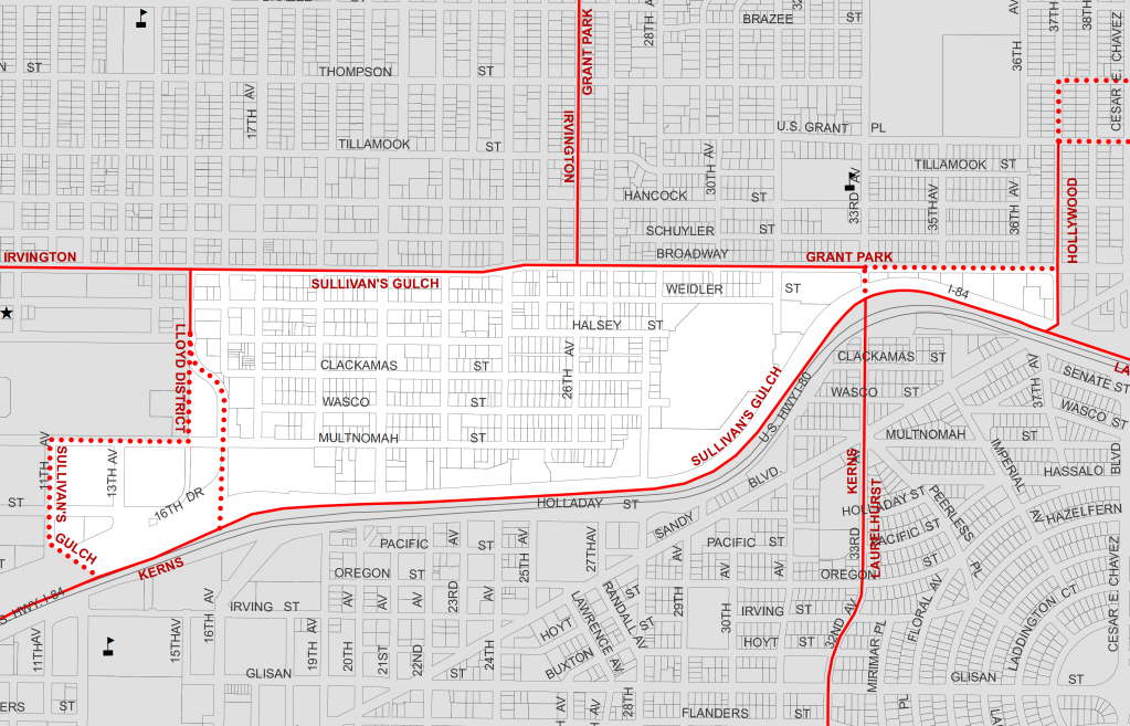
Regular AH readers know we have a fondness for Portland’s plat maps. Within Sullivan’s Gulch alone are at least eight underlying plats filed by developers, beginning with the earliest in about 1870. Plats are essentially subdivision plans for lots and streets, filed with Multnomah County. Sometimes called additions—plat boundaries are different from neighborhoods. Today’s neighborhood names are essentially social-political boundaries; plats are engineering plans. Here’s the Sullivan’s Gulch neighborhood today, according to Portland’s Office of Community and Civic Life:
More than 900 plats make up today’s City of Portland, most of them filed during the early years, by developers trying to make a favorable impression by choosing an attractive sounding name. As it turns out, what things are named is a big deal.
Something notable about plats in today’s Sullivan’s Gulch is that they were some of the earliest on Portland’s eastside, dating to the 1870s at a time when Portland was actually three towns: Portland, which was basically just the westside; East Portland, where these plats are located; and Albina to the north and east. In 1891 these three separate towns combined to create the City of Portland.
For the record, there is an actual plat called Sullivan’s Gulch, but it was filed just five years ago and relates only to about a block and a half near the corner of NE 21st and Multnomah. And of course there is the Sullivan’s addition of 1870, platted by John J. Sullivan, son of the original homesteaders Timothy and Margaret Sullivan. But let’s not get ahead of ourselves.
Turning the clock way back, we know the Gulch was shaped by the cataclysmic floods that coursed across the region associated with the breaching of ancient Lake Missoula.
We also know and acknowledge that these lands (and all lands that make up Portland today) were taken from the Multnomah and Clackamas bands of Chinook, the Tualatin bands of the Kalapuya, the Molalla, and many other family bands and tribes, who were then forcibly removed from the home their ancestors knew for 500 generations.
The first people—who lived here and knew these lands for 10,000 years before Portland became Portland—traveled the length of the gulch and other routes between the Willamette and Sandy rivers.
Here’s the first map produced by the U.S. Government Land Office and the Surveyor General showing the surrounding area, including the Timothy and Margaret Sullivan Homestead. There’s lots to look at here, and we’ve added a few pointers in red for context.
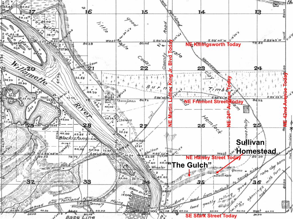
Government Land Office Survey Map, 1852. Note that Boise-King-Sabin-Alameda-Beaumont-Wilshire was a wide swath of “burnt timber” and that Swan Island really was an island. The “Road from Portland to Tualatin Plains” roughly aligns with parts of today’s Canyon Road and the Sunset Highway. Portland was just a small grid of streets on the west side of the river (where the waters were deep enough to anchor ships).
Homesteader Timothy Sullivan left his native Ireland before the famine struck in 1847 and came to Portland about 1850 after a short time in Australia, where he met and married wife Margaret. They both became US citizens in 1855 and received title to the property from the U.S. Government in the early 1860s.
About that time, the Sullivans sold a portion of their new homestead to the Archdiocese of Portland, directly north across the street from Lone Fir Cemetery at SE Stark and 24th. Catholics could not be buried at Lone Fir Cemetery in those days, so the Diocese created a cemetery of its own—St. Mary’s Cemetery—which operated from 1858 until 1930 when the remains were relocated to the new Mt. Calvary Cemetery in southwest Portland. The site of the old St. Mary’s Cemetery is today’s Central Catholic High School.
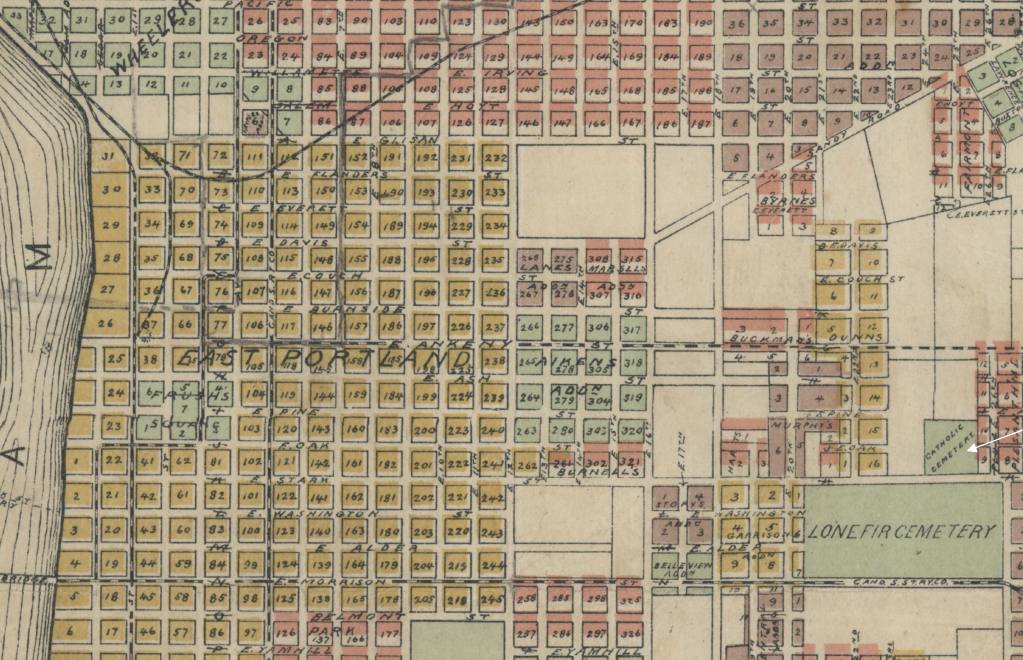
Location of the former St. Mary’s Catholic Cemetery (indicated by arrow) on lands that were originally part of the Timothy and Margaret Sullivan homestead. The site of today’s Central Catholic High School. Map source: City of Portland 18982 Renaming Map by Stengele & Schiffers, Courtesy of City of Portland Archives.
Timothy Sullivan died in the 1860s and widow Margaret in the 1880s. Yes, their remains were buried at St. Mary’s Cemetery and later exhumed and relocated to Mt. Calvary Cemetery.
Here’s one of the few visible clues to the Sullivans today, this one-block long stretch of “Sullivan Street,” which is actually more like an alley (there aren’t any street signs here, just the ghostly Google label), perched on the south edge of the gulch behind Oregon Mt. Community at NE 29th. Directly behind this view, the street sweeps to the east, down the hill and under the Banfield for access to the U-Storage building, which is the old Doernbecher Furniture Factory.
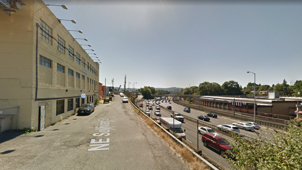
Looking west along the Banfield Expressway (Interstate 84). Google Streetview image.
The Sullivans knew the area when it was a wild and somewhat remote place. But after their passing, when the railroad arrived in the spring of 1882, builders began to fill in the lower part of the Gulch to make way for the rails and to protect from Willamette River floodwaters. They also built the first steel bridge across the Willamette, the Albina yards to the north, and lots of infrastructure.
Here’s, a birds-eye view from 1890 looking west. This map was produced to market properties in Ben Holladay’s addition, which as we can see just happens to be at the center of the Portland universe. The red arrow indicates the location of the old Sullivan Homestead–and a water source / favorite bucolic picnic grounds known as Sullivan’s Springs–near today’s intersection of NE 19th and NE Pacific Street.
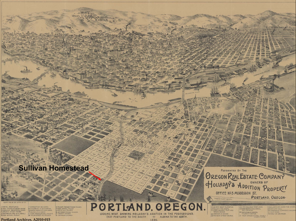
Oregon Real Estate Company birdseye view, 1890. Courtesy of Portland City Archives, A2010-015
And just because we’re a little crazy for old maps and photos—and on the chance you might not already know about it—below is an amazing photograph from 1903, one of 14 tiles in a giant panorama called the Henrichsen Panorama, looking right at the mouth of the Gulch in 1903. You could spend an hour looking at this photo and its 13 siblings, but we’ve pointed out a few places on this one panel just for orientation, and to help you visualize this landscape before things really exploded on the eastside.
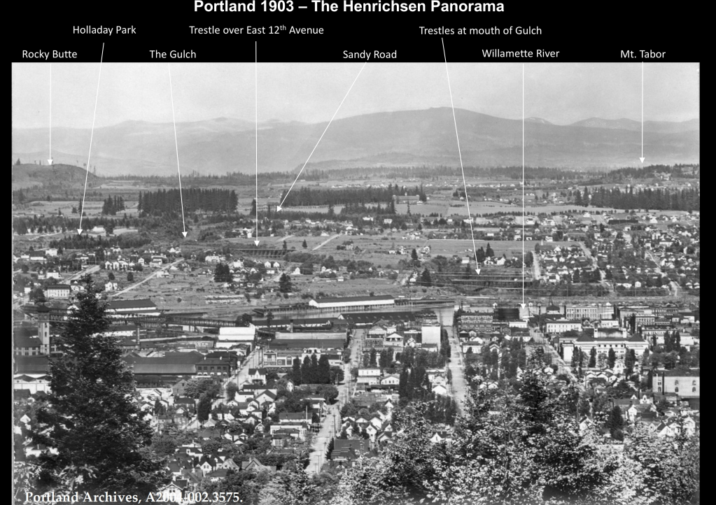
The Henrichsen panorama, one of 14 images taken in 1903. Courtesy of Portland City Archives. Image A2004-002.3575.
Arrival of the railroad ushered in a whole new wave of change for the Gulch and for Portland, including the siting of heavy manufacturing right alongside the rails for easy transfer and shipment. In our next post, we’ll explore the tension between industrial use in the Gulch and growing residential use in the uplands to the north and south.
Next: In the early 1900s, the gulch became a magnet for manufacturers and for neighborhood kids seeking adventure.
