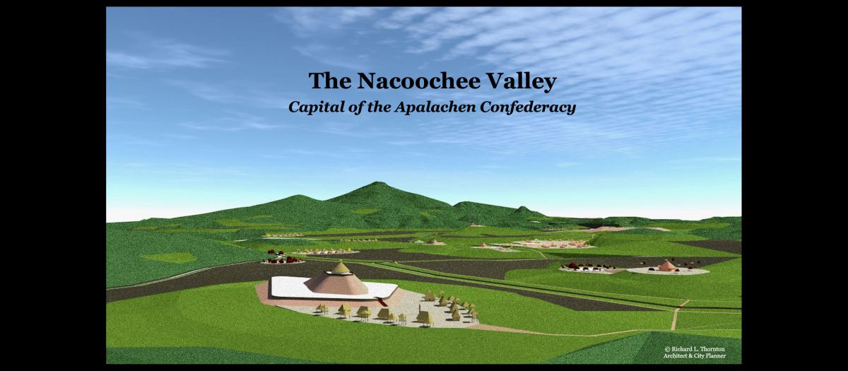
In the Nacoochee Valley near Sautee, Georgia
by Richard L. Thornton, Architect and City Planner
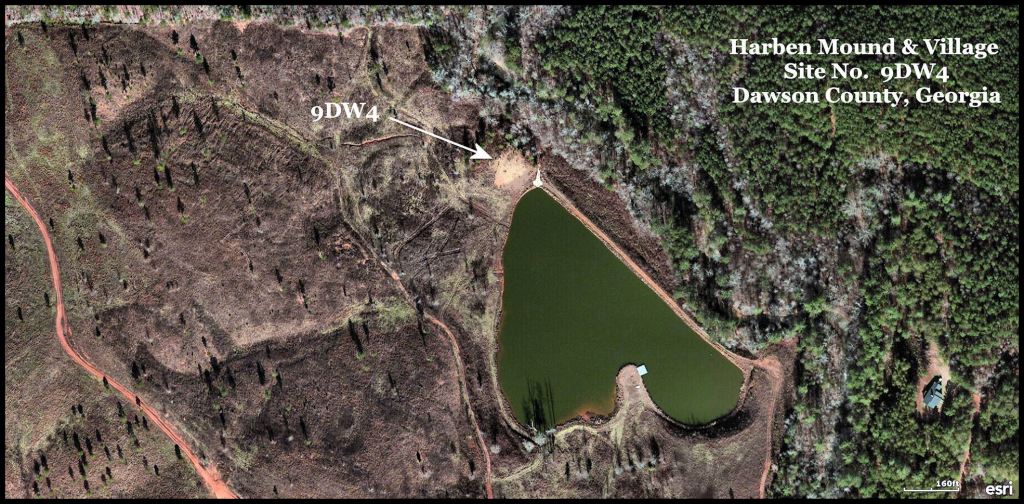
In our previous article, we described the architecture of the Stovall House and its history since 1937. It is now an inn. However, little known to its guests and even those living in the Nacoochee Valley, this farm contains a very important Native American archaeological site, 9WH18, which was first identified by archaeologist Robert Wauchope in 1939, but never understood by Wauchope. The intense concentration of artifacts and extensive terracing on this knoll next to Chickamauga Creek could not be explained.
In this article I am going to lead readers through the discoveries over the past seven years, which enabled me to unravel the mysteries of this beautiful farm’s past.
Location: Latitude – 34°28’50.9″N ~ Longitude – 84°12’40.0″W
While living in that rat-infested cabin between Dahlonega, GA from spring 2012 through spring 2018, I tried to locate the archaeological sites nearby. Most of the sites were first identified by Robert Wauchope in 1939 and have been ignored . . . even lost . . . since then.
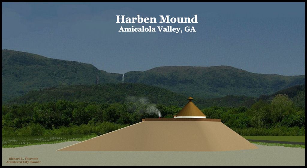
The Harben Mound was the tallest and best preserved earthwork, identified by Wauchope, during his year and a half in Georgia . . . except that he never saw it! Two ladies told him about the mounds and stone ruins along the Amicalola River. Wauchope found a 3,000 year old town site at the Edge of the World Rapids on the Pickens County side, where GA Hwy. 53 now passes over the Amicalola River. He was given specific directions to a large mound upstream from the rapids, but because of the lack of road signs, he was never able to find it. Actually, he pronounced the name of a road incorrectly and so locals could not direct him to the right farm. Nevertheless, so many people affirmed that the mound did indeed exist that he assigned it a state archaeological site number.
The Harben Mound was still largely intact, when I first discovered it in 2015. It is oriented to the Winter Solstice Sunset like Mound A at Etowah Mounds. At the time that I measured it, the mound was 280 feet long, 110 feet wide and 40 (12.2 m) feet tall . It has an extremely long ramp on the southwest slope and in fact, is quite unusual architecture for the Americas or anywhere else in the world. Unfortunately, after I discussed the mound on the telephone with a couple of friends, someone in Georgia law enforcement telephoned the owner and told him that “I planned to claim his land for a Indian Reservation.” The owner immediately began bulldozing the structure.
On the latest satellite imagery, the mound has been completely destroyed. What’s really frustrating about dealing with such situations of public employee corruption is that the owner could have made a small fortune selling tickets and giving guided tours of this massive mound. The mound was located five minute from Amicalola State Park and the starting point for the Appalachian Trail.
Fritchey Mound
The only date that I have had in the past eight years was with an Italian architecture professor, I met at a store in Helen, GA in 2019. To thank me for giving her a tour of the Nacoochee Valley, she gave me an infrared video camera and binoculars for my birthday. I am using it to find the dark stains left in soil by human occupation and buildings.
With the infrared device I found the footprint of a mound identical in size to the Harben Mound, in a plowed field on GA. Route 17 about 3/4 mile from my house. The Georgia DOT had scooped up the mound in 1993, to make landfill for highway construction. Even then, the GDOT had archaeologists on its staff, but they were not notified.
At any rate, I had measurements for two large, identical mounds of unusual design. Both were on the southern flank of the Blue Ridge Mountains.
Analysis of the Stovall Farm
In 2016, I also was hunting down the archaeological sites, studied by Robert Wauchope in Nacoochee Valley, in preparation for writing The Nacoochee Valley . . . Crossroads of the Americas.
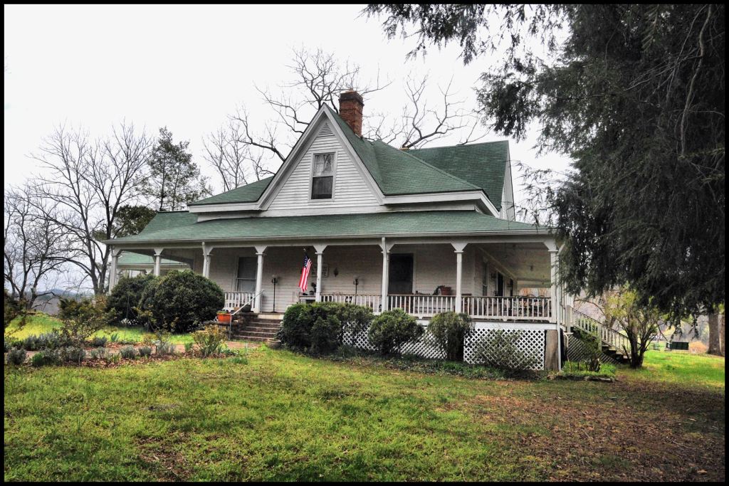
I paid a visit to the Stovall Bed and Breakfast. The knoll overlooks to the south, the convergence of Bean Creek with Chickamauga Creek, plus the beautiful Sautee Creek Valley to the east. The owners mentioned that from time to time that had found pieces of pottery and stone tools throughout the farm. They were not aware that their house was an official archaeological site. Being an architect, I immediately notices an ancient stone retaining wall and very old terracing that surrounded the house.
Typical of what Wauchope also found elsewhere along the headwaters of the Chattahoochee River in Northeast Georgia, the occupation of the this farm went back about 3,000 years. Wauchope was not allowed to dig explorative ditches, but did dig some small holes and looked at artifacts, found by occupants of the house while plowing or gardening. He identified Deptford (Early Woodland), Cartersville Check Stamped (Middle Woodland), Swift Creek (Middle and Late Woodland), Napier (Late Woodland). Etowah I (Early Mississippian), Etowah II (Middle Mississippian), Lamar (Late Mississippian) and Late Lamar (Colonial Period) pottery. Wauchope made not mention of the terracing, but apparently dug most of his test holes in the front yard, which was obviously the remnants of a mound.
I returned to the Stovall Farm in 2017 The owners allowed me to measure the dome of earth in the front and the terraces. I was surprised that everything around the house’s terrain was symmetrical and that the terracing formed a V shape pointing exactly due south. This was odd, but I gave the situation no further thought until discovering the clone of the Harben Mound on the Fritchey Farm at the eastern edge of the Nacoochee Valley.
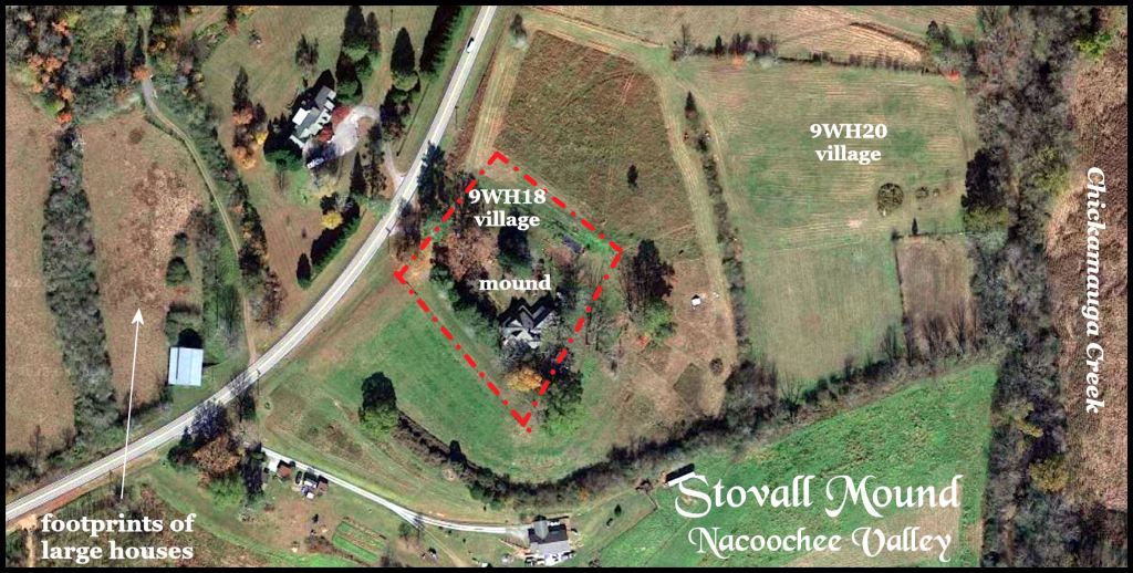
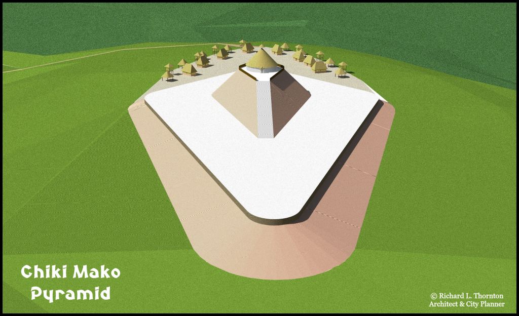
The upper terrace at the Stovall Farm form a perfect diamond, pointed toward True South, which is a few degrees different that Magnetic South. The diameter of the dome-shaped mound in the front yard of the house, exactly matched the width of the Harven and Fritchey Mounds, where the two axes crossed. The house was constructed on the ramp portion of this third identical mound.
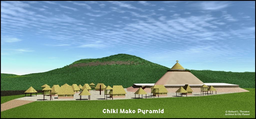
Wauchope found the greatest concentration of potsherds in the front yard in the northeastern pasture, where one can see a larger oval area of green grass. The proportions of pottery styles were different in the two areas, so he labeled the front yard 9WH18 and the northeastern pasture ad 9WH20. Apparently, in at least some occupation periods, the elite lived on top of the hill near the mound, while the commoners lived along Chickamauga Creek. Below is a site plan and two more virtual reality images of the earthen pyramid and elite village.
All VR images were made from the recently completed Chattahoochee River Headwaters Virtual Reality Model. It covers the rugged terrain of the first 12 miles of the Chattahoochee River. It took me 14 months to create this computer model!
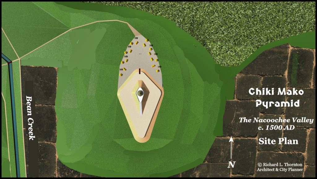
To the southwest is the Lumsden Village Site
To the south of the archaeological site is Lynch Mountain, which is a collapsed caldera.
View of the pyramid and village plaza, looking north.
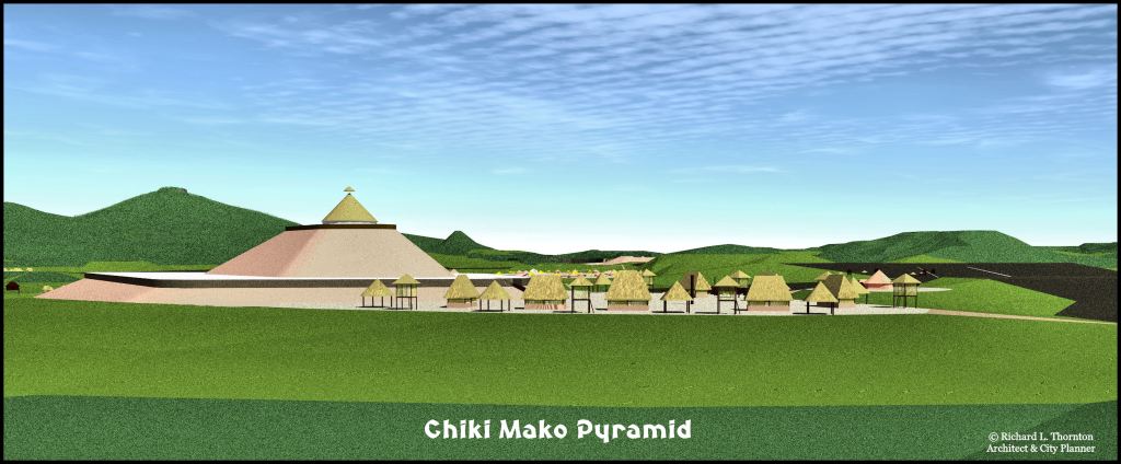
West elevation, looking toward the main Nacoochee Valley.
The place name, Chickamauga, is the Anglicization of the Itza Maya words, “Chiki Mako” . . . which mean “House of the King.”
