
By Carolyn Kennett
First published in Meyn Mamvro 95 (Spring/Summer 2018) and still can be read in the collected works Watching the Sun Booklet by Meyn Mamvro and Mayes Creative (2021)

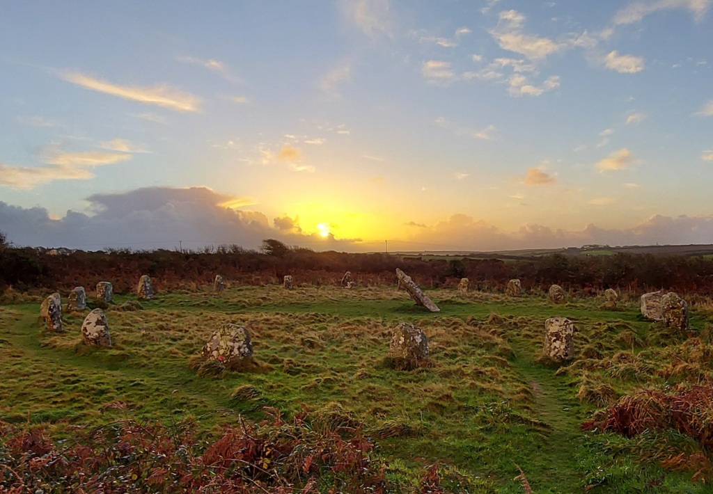
Boscawen-ûn summer solstice sunset (Credit Carolyn Kennett)
During the last few years, in many ways, Boscawen-ûn became a second home to me. While waiting for sunrises and sunsets I observed the change in the seasons at the circle, all accompanied by the changing looks, sounds and smells. But one thing remained the same and that was the tranquillity of the site. I kept some strange hours, as I was mainly there for sunrises or sunsets and quite often at night. More often than not I was alone in the circle, sometimes for hours on end. One of these visits, in particular, comes to the forefront of my mind. Having risen when it was still dark, I drove to the circle with the beginnings of dawn, hoping the low developing horizontal cloud would clear. I arrived in time for the sunrise of the 25th June 2016. The week had been wet and the solstice had passed behind a thick blanket of cloud. I stood atop Creeg Tol willing the low bank of clouds to blow out of the way, even though I knew I was nearly a week late to see the summer solstice sunrise. The vantage point of Creeg Tol meant that I would see the Sun peer above the horizon, something that I could not replicate in person in the circle below due to the large hedge obscuring this direction. The dawn had a stillness about it which makes it one of my favourite times of the day. The clouds were starting to disperse and right on schedule, the Sun started to peer above the horizon, accompanied by the mixed dawn chorus of birds, roosters and cattle. I photographed the sunrise from my vantage point at Creeg Tol and set off down the hill towards the circle. About halfway down into the hill I started to lose the sunrise, the Sun was setting behind the hill it had just risen from. By the time I reached the circle the Sun was once again well below the horizon. I realised that without the hedgerow I could witness the Sun rising twice, in effect a double sunrise. Once from atop Creeg Tol and then again from inside the circle. I hoped this would work in reverse: with the Sun setting visually from the circle and once again from Creeg Tol. It was an idea I would test out repeatedly over the summer months with great success. I think this double sunset and sunrise during the summer months is one of the most visually beautiful aspects of the circle. A local settlement Goldherring, which has some Bronze Age round huts is north of the site and people could have accessed the circle from the direction of Creeg Tol. Double sunsets and double sunrises are something that we can all witness from the site and this is only the beginning of what makes Boscawen-ûn astronomically special.
It is important to consider Boscawen-ûn in the landscape as holistically as possible. During this project, I wanted to consider the way the circle sat at the base of the northern hill, in what would have been a marshy area and quite possibly difficult to get access to, particularly at wet times. Why had it been positioned here? What would have been seen in the sky? It was equally important to view the site as a part of a changing landscape, where man has shaped and changed the site itself over a large period of time as well as the surrounding landscape. I am a great believer in looking what archaeoastronomy ideas have been historically suggested about a site. These historic ideas brought another list of questions such as: Is there any truth in a Lunar link at Boscawen-ûn? Does the carving on the back of the central stone light up at summer solstice? These were just the start of a list of burning questions that would keep me returning to the site, making measurements, and calculating positions of celestial objects over the coming year. Hopefully enabling me to answer if the site was built with astronomy in mind.
I started by considering if there were any alignments between the circle and features on the horizon. This meant that I needed to map out all the natural and man-made features which would have been found from the period of the stone circle. This was in itself quite a task. The internet was a wealth of information, but local knowledge from people such as Cheryl was a great help to me. Many local sites such as barrows and menhirs had disappeared and I needed to try to reconstruct where they were as accurate as possible in relation to the circle. My final list identified 48 local features or as I would name them, targets. These targets would then be considered against a number of pre-selected celestial events. If all 48 targets were considered against the chosen celestial events, statistically a match would be highly likely. For instance, if we were to consider the targets located around the site in a circle of 360 degrees. If each target considered covered 1 degree with an error of +/- 0.5 degrees a total of 96 degrees or just over a quarter of our circle would be covered in targets. (The error from this project was set as 1.04 degrees this came from a small amount of measurement error as well as error for refraction, extinction, and parallax). Statistically, this would mean that it would be far more likely for a target to make a match with a considered event. Therefore to make the project more robust I needed to reduce the number of targets. I decided first of all to consider targets that were visible from the site and only targets that sat proud against the horizon. The reduction in targets could have been undertaken in a number of ways but I felt that this made the most robust format for retesting any results. This left me with just 7 remaining targets out of the original 48 to match with my events. These were as follows:
The Lamorna Gap – yes it is just visible from the site through the hedgerows. A smaller sea gap further south to the Lamorna gap, Creeg Tol. A barrow just west of Creeg Tol, Chapel Carn Brea, Boscawen-ûn Field Menhir and finally Bunkers Hill Menhir (East). Once the targets were identified I made on-site measurements of their azimuth and altitude and this was converted into an astronomical declination. Alongside the on-site measurements, I ran a computer program called HORIZON. This also gave me declinations for my 7 targets and it acted as a test of accuracy for the on-site measurement, as well as allowing for reconstruction of the horizon behind the hidden, hedgerow covered NE direction.

Boscawen-ûn Field Menhir, with possible fallen menhir in hedge behind (Credit Cheryl Straffon)
Next, I considered which astronomical events I would examine alongside the targets. I decided to look initially at five events in total. These five events would give 14 positions along the horizon: 7 rising positions and 7 setting positions. These were the extremes of the solar calendar or the solstices, as well as the solar equinox positions. I also considered the lunar standstill positions both for lunar major and lunar minor. I then calculated the declinations of these 14 events for a date of 2500BCE. The horizon position of a solstice Sun and the lunar positions in 2500BCE has moved slightly compared to its current position, whereas the equinox would be in virtually the same place. So a rising solstice Sun would have a declination of 23.9 degrees in 2500BCE whereas it would have a declination of 23.4 degrees currently which is on a flat horizon at the latitude of Boscawen-ûn equates to an azimuth difference of 1.02 degrees.
When all this was considered I could look for matches between my 14 events and 7 targets. I could see immediately that 4 of my 7 targets declinations matched with one of the fourteen identified events, within the limits of the error I had set. The first and probably most primary of these is that an observer in the circle at 2500BCE would see the winter solstice sunrise rising from the Lamorna Gap. The Lamorna Gap at present is obscured by hedgerows, but without this vegetation would have been a subtle sea view at best. The Lamorna gap declination was measured as -23.6 +/-1.04 degrees, matching a winter solstice sunrise of 23.9 degrees. Also, you must consider that the sea view extends for more than 1 degree along the horizon and that this event could be observable over the coming millennia.
This first alignment extends through the circle to my second alignment. This is to a barrow which is no longer visible, it was located to the west of Creeg Tol. It would be in the position of the summer solstice sunset when observed from the circle. It had a measured declination of 24.3 +/- 1.04 degrees coinciding with the declination of 24.9 degrees. Equally an observer at the barrow would have been in a position to observe the winter solstice sunrise out of the Lamorna Gap. Its position just above the circle would give an observer a more advantageous height and a more pronounced view of the winter solstice sunrise from the Lamorna Gap. It is interesting to note that the winter solstice sunset at this time would just fall into the large sea gap at the Tregeseal stone circles. Although at Tregeseal the sea gap is far more pronounced, there is possible that there is a connection between the two sites on this date.
The other two matched alignments came between the circle and lunar major standstill positions. I found that the position of Creeg Tol matched the lunar major sunset northernmost position, it had a measured declination of 28.3+/-1.04 degrees coinciding with an event declination of 28.9 degrees. The nearby Boscawen-ûn Field menhir was the final alignment and it was in the lunar major sunrise position. This had a measured declination of 28.9+/1.04-degrees which coincided with the event declination of 28.15 degrees in 2500BCE. The position of the Field menhir was slightly to the west of calculated declination for the lunar alignment, but it is conceivable that another stone now recumbent in the hedge made a pair and this pair once framed the rising Moon at the extreme of the lunar major cycle. Although we should note here that it may not have necessarily been a full Moon at that time, as the Moon at its standstill declination can be at a number of positions within in its phase cycle.
Lunar standstill links are not well documented in Cornwall. They are considered a feature of recumbent stone circles in East Scotland but have also been found in western Ireland and more recently in western Scotland. The discovery of two lunar standstill points at Boscawen-ûn is both interesting and intriguing; raising more questions than it answers. Boscawen-ûn does have myths surrounding it which are linked to the lunar cycle, so this could be a feature of this site. Future work in west Penwith will consider evidence for lunar links. For instance, the Merry Maidens which I had discounted through my reduction of data, as it did not stand proud against the horizon is in the Lunar Major Standstill Southern rising position from Boscawen-ûn with a declination of 29.9 degrees. This concludes the main horizon findings but as I said I also looked at other features within the circle.

Boscawen-ûn hedge menhir (Credit Carolyn Kennett)
The positioning of the quartz stone to the SW of the circle could signify the start or end of the winter season, but due to its localised vicinity to an observer, it could never pinpoint an actual date, without another position to line it up. The stone on the opposite side could have well been used to align the position but this does not line up with anything calendrically significant. The quartz stone does though align with the cist (located in the NE of the circle) and the out of sight Boscawen-ûn Hedge menhir. The summer solstice sunrise would have occurred along this alignment around 2500BCE. This alignment was first suggested by Norman Lockyer in his consideration of the circle. There is another stone between the Hedge menhir and the stone circle, this would possibly bring inter-visibility between the circle and the Boscawen-ûn Hedge menhir. Even so, there are numerous examples of standing stones being just over brows of ridges that form alignments so this could be a viable consideration when looking at this alignment.

The edge of the foot at the bottom of the central stone is illuminated (Credit Carolyn Kennett)
Rock art carving (or either foot or axes) have been identified on the central stone. I was able to calculate the amount of time the art would be illuminated for in the year 2500BCE. The art on the back of the central stone is only fully illuminated in and around summer solstice sunrise. Without any vegetation, a full illumination would occur for 30 days on either side of the solstice. The maximum time in minutes that the art would be illuminated would occur on the summer solstice. This amount of time would reduce each day until a full illumination could not happen 31 days later. It must be noted that this measurement takes into account a completely flat landscape. Any vegetation would significantly reduce the length of time and amount of days the art would be fully illuminated. Partial illumination of the art also occurs and this time it happens both in the morning and the evening in and around the summer solstice, this partial illumination would occur over a much longer period.
There are many more suggestions that could be made particularly linking stellar events to the site. Without more accurate dating these suggestions must be taken under advisement. For instance, the Pleiades would set over Chapel Carn Brea in 1500BCE but at an earlier date of 1800BCE, it would have set to the south of the framed hill. I did consider if the central stone could have pointed at a star. The only bright star that it could have pointed at was Arcturus and this would have been at a remarkably early date of 3820BCE. This must be taken under advisement, as the stone could have moved over time. Overall the suggestions of stellar alignments without accurate dating are always difficult to suggest. It does seem that a number of astronomical features were considered by the builders of Boscawen-ûn. They certainly had an eye for the solar calendar within the design but perhaps more unusually a knowledge of the lunar cycle. This project, for me, has raised more questions than it answered and I will be continuing it by looking for further examples of lunar alignments within Cornwall and trying to draw more conclusions about the astronomical features at some of the other Cornish circle sites.
More of this story can be read about in my book Celestial Stone Circles of West Cornwall. Which can be accessed here

Pingback: Sun and Moon at Boscawen-ûn — Archaeoastronomy Cornwall | Die Goldene Landschaft