
How to choose a favourite hillfort……
A difficult decision. Particularly in Dorset…..a county adorned with the finest hillforts in the land.
But if you were to choose.

Drone photo of Hambledon Hill after light snow
Perhaps it would be Hambledon. A huge, beautiful earthwork… curled like a sleeping beast. Walking along its spine is like flying out over the Blackmore Vale.
Or would it be Eggardon, along the Roman road from Dorchester, A to B to Minor… barely a track when it reaches the hillfort. A routeway into time.
The view west across the Marshwood Vale from Eggardon Hillfort
Here, the chalkland ends. The landscape drops away. Falling out into Marshwood’s deep green network…. hazing out into Devon.
Perhaps Hod Hill, two in one. The largest hillfort in Dorset with a Roman camp stamped into its highest corner. From here, all the surrounding country is visible.. where the rivers Stour and Iwerne meet. Straight lines over rounded Iron Age contours.

Nick Skelton’s drawing of Hod Hill for the NT Dorset Hillforts Guide. Showing the hillfort after the Roman fort had been constructed.
The Roman soldiers, a unit of infantry and a unit of cavalry, occupying long rectangular lines of barracks and stables. Invading foreigners, evicting the natives from their thatched round house homes. A torn place, converted into so much debris, levelled by the occupying forces.
An archaeological choice. Partly excavated in the 1950s by Sir Ian Richmond. From the things he found, the soldiers were here for about 20 years. Long enough for the locals to begin to accept their new situation…. within the Empire.
Before that, people had occupied Hod for about 300 years. Quite a place. Imagine the scale of work involved in making it.. and the organisation required.
Dave’s geophysical survey data from Hod is exceptional. Like an x-ray through the grass. It shows a network of streets spreading out from the hillfort gateways, lined with hundreds of round houses. Here were the patterns of post-holes, the many square granaries and the black blobs from hundreds of grain storage pits. The wealth of this warrior agricultural community.

David Stewart’s magnetometer survey of Hod Hill showing the density of round houses and storage pits within the hillfort and the trackways fanning out from the gateway (bottom right)
No wonder the Romans occupied this important location. A settlement of such scale.. it spilled out of the hillfort and down along the the Iwerne Valley.
If you go there, particularly in winter, when the grass is short and the sun casts low shadows.. the hollows of the round houses are clear. Walk down a 2000 year street.
If you go there in June, walk the ramparts and watch the clouds of butterflies rising from the orchids along the southern slopes.
Perhaps the choice was Hod Hill…
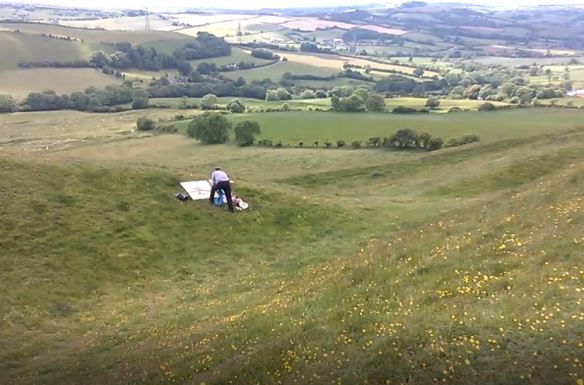
But… last week…. I arranged to take the new curator round… 6 hillforts in a day. Coney’s, Lambert’s, Pilsdon….
By mid-day we had climbed the narrow road from Askerswell, parked in a lay-by and followed the hedge-lined path to Eggardon’s earthwork gateway.
Such a quiet place, the three rings of ramparts stepping down over a curving valley and the grassland twinkling with yellow flowers.
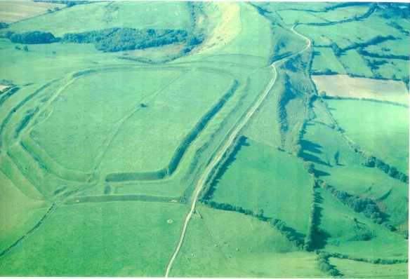
Aerial photograph of Eggardon Hill looking south-west. Parish boundary bank dividing the hillfort in two. The National Trust half is on the left.
In the distance was a man with something spread out in front of him.
As we approached, we could see that he had a large canvas and beyond lay the sweeping bowl of Marshwood and the Golden Cap coast. How to capture the vast deep green wonder of it? His painting was a fine attempt.
We sat amongst the flowers on the middle battlement and had our lunch…. looking back along the escarpment edge to Pilsdon, Lambert’s and Coney’s
And in the afternoon we went on to Hod and Hambledon…. though I left my heart at Eggardon…. Why had I stayed away so long?
Sometimes we are surprised by moments but we cannot take them for granted. I went back early yesterday to share the experience….but there was deep fog and torrential rain..
Information on Eggardon:

Nick Skelton’s reconstruction drawing of Eggardon Hill for the NT Dorset Hillforts booklet. It shows the fort after the landslip through the ramparts on the southern slope and all the Iron Age round houses within seen as earthwork hollows and on Dave Stewart’s geophysical survey of the site.
- Crossed by parish boundary Powerstock/Askerswell. Trust owns the best preserved southern half.
- Like Badbury this place gave its name to a Saxon Hundred (district court) meeting place
- There are two barrows in the hillfort, that to the north has been levelled by past ploughing and that to the south is still an earthwork but was dug in antiquarian times and again in 1965 by George Rybot. He found the cremated remains of an adult and child c.3500 years old.
- He excavated the long linear banks that criss- cross the hillfort interior and dated them to the Early Iron Age about 500 BC. He excavated the hollows and circular banks and found them to be round houses and storage pits.
- There has been massive collapse of the southern ramparts… later partly repaired… so the land slip is thought to have taken place in the Iron Age.
- The entrances are at the east and west ends where the land is level and needs strong defences. The fenced land ownership along the parish boundary runs through the gateways.
- A 70m wide octagonal earthwork enclosure on the summit marks the position of a tree clump.. is said to have been planted by Isaac Gulliver in 1776, the owner of Eggardon Farm and a notorious smuggler. The plantation was used as a mark for ships to bring contraband to the Dorset coast.

SO interesting, as usual. Helped me see with new eyes and want to visit as soon as possible! Thank you .
My personal favourite has always been Maiden Castle. We went up there when our children were small and despite the impressive scale of the earthworks the thing that struck me most was the thought that 2000 years ago similar children would have called it home and played there. It’s an image which has always stuck with me.