I’ve traversed many a mountain-strand,
Abroad and in my native land,
And it has been my lot to tread
Where safety more than pleasure led;
Thus, many a waste I’ve wander’d o’er,
Clombe many a crag, cross’d many a moor,
But, by my halidome,
A scene so rude, so wild as this.
Yet so sublime in barrenness,
Ne’er did my wandering footsteps press,
Where’er I happ’d to roam.
Sir Walter Scott

The Derryveagh landscape of County Donegal is one of windswept heaths, desolate valleys, charming lakes and savage crags. Its elegant mountain-tops varies from granite cones to quartzite domes. No structure reflects this contrast more so than the haunting ruins of the roofless church in Dunlewy. The church’s walls, built in 1845, are a blend of granite and white quartzite marble, reflecting the contrasting rocks of the neighbouring peaks of Slieve Snaght and Errigal respectively.
Visitors to these parts were scarce in the eighteenth and nineteenth centuries, for the most part due to the inaccessibility of its barren and bleak landscape. Some however, did venture here, like the Victorian traveller Samuel Carter Hall, who in 1840 referred to its landscape as ‘unequalled in Ireland for wild and rude magnificence’.
There is only one mountain over 700m (2,297 feet) in Donegal but do not let statistics deceive you as it is truly one of the most attractive counties in Ireland to hike in. About two-thirds of her 480,000 or so hectares consist of rough uplands over 200m above sea-level and some 10,000 hectares are water-filled to include lakes and sea-inlets. If it is wilderness, beauty and solitude you seek, then seek no further than County Donegal, and there is no better place to start than the Derryveagh Mountains.
Iconic Errigal


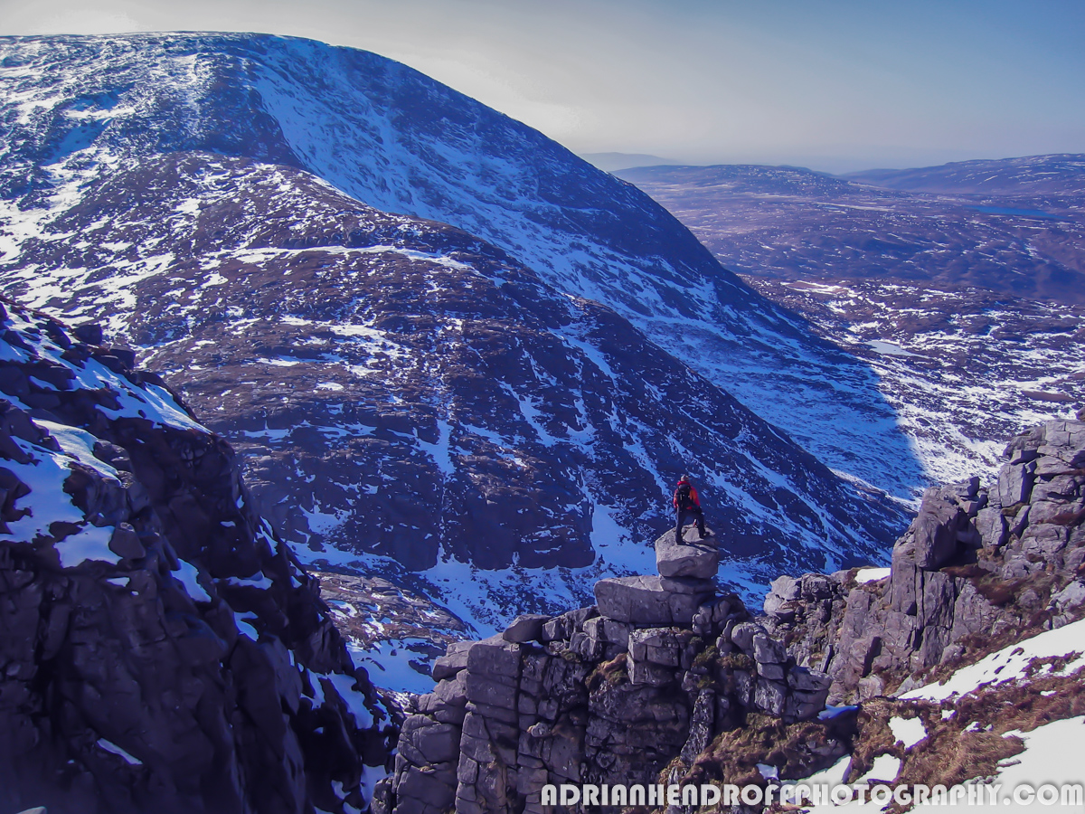
I once spent a bitterly cold midwinter afternoon on Mount Errigal alone, and in quiet reverence in the arms of Donegal’s highest peak. A stream of clouds drifted on the eastern end of its ridge, enveloping the deep chasm below. On the opposite end, the sun burst through the fleeting mist, at times revealing my shadow, magnified tenfold, encompassed by halo-like rings of a rainbow on the clouds below. But suddenly the clouds parted and the mist dispersed to reveal an unparalleled view of mountain, lake and coast accompanied by the most glorious of sunsets.

The sharp crests of Errigal’s north and west ridges fall more than a thousand feet below. I spotted two blue lakes, each separated by a causeway and extended across the land like the arms of a welcoming giant. The neck of the longer lake, Nacung Upper, narrowed as it meandered toward the village of Gweedore. To the far west and north, a boundless length of baroque indentations, fretted islands and blue bays weaved its way along the Atlantic coastline. The most striking view lay to the northeast, beyond the drumlin studded and scree-littered landscape below Errigal’s sheer east face. A suite of crenellated quartzite peaks danced like waves toward the distant horizon: Mackoght, Aghla More, Aghla Beg South and Muckish. Finally, to the south, I saw the stark beauty of the Poisoned Glen guarded by the imposing granite dome of Slieve Snaght.
Although this route is only 5km and involves around 500m (1,642 feet) of ascent, do respect it as there is a steep, scree slope to negotiate and the summit ridge is exposed, so take care on windy days. The trail is marked by a set of cairns up to the shoulder of Errigal’s south ridge. After a stone-circle shelter, you’ll pass another string of cairns along the ridge which undulates to the first of Errigal’s summits. All that now remains is to traverse the narrow ridge linking that to its twin summit and you’ll have the world at your feet.
The Pig’s Back


Muckish Mountain is truly one of Donegal’s distinctive landmarks. From the south along the R251, it looks like an upturned ark. Its distinct outline can also be seen along the coastline, from as far as Bloody Foreland and Horn Head. The Irish for it, An Mhucais translates to ‘the pig’s back’. Its summit plateau – around a kilometre long – is stony, rocky and barren like the surface of the moon. Its rock is essentially quartzite, and the northern and southern sides of the mountain are bedecked with vertiginous cliffs and crumbling scree.

This walk describes an out-and-back route up Muckish from the south. Park at the roadside grotto under a grassy knoll at B 999 268 along the R256 or at the lay-by on the right just after. Access the hillside from the lay-by, ascending initially northeast, then later veer northwest. The slope is quite steep until you reach a grassy shoulder. Later, cross a band of loose rock and pick a well-worn scree path to reach a flat area marked by a rock cairn. Gradually veer northeast until finally reaching a trig pillar sitting on a rocky mound. There is also a cross standing on another rocky mound slightly further ahead.
The panorama is all-embracing and includes the Donegal coastline from Malin Head to Bloody Foreland. The sand dunes of Horn Head to the north may also be seen. The tip of peaks culminating at Errigal can also be seen to the southwest across the moonscape rocks of the Muckish plateau.
The Mountain Of Snow


Although the summit of Slieve Snaght (Sliabh Sneachta, ‘mountain of snow’) is a wide plateau of short grass, its approaching slopes are steep, uneven and rocky. If you’re lucky enough to stand at its summit cairn, you’ll enjoy far-reaching views of all the Derryveagh Mountains including Errigal and Muckish, as well as much of the coastline and islands of North Donegal.

The approach to Slieve Snaght is from the depths of the Poisoned Glen. It is believed that the Irish Spurge (genus Euphorbia) once thrived along a stream that drains the glen. It is a toxic plant, whose stems and leaves contain a caustic, poisonous milky sap.
Another is a legendary tale involving the warrior Lú and a ruthless pirate named Balor. The latter had a basilisk in his forehead which killed his enemies with a single glance. When a prophecy warned Balor that he would be slain by his own grandson, he imprisoned his daughter Ethniu in a crystal tower on Tory Island. However, a man called MacKineely, infiltrated the tower and seduced Ethniu. She gave birth to triplets. Upon finding out, Balor drowned them in the sea and killed MacKineely. Unknown to Balor, one of the babies fell into the harbour and escaped. Raised by his father’s tribe, the Tuatha Dé Danann, the child grew up to be the warrior, Lú. Years later, Lú seeks out Balor for revenge. It is said they fought in the Poisoned Glen, scarring its cliff faces. Eventually, Lú pierced the sinister eye of Balor with his spear, killing him. A vile fluid poured out of Balor’s eye that is said to have poisoned the Glen!
The approach to the summit is via Slieve Snaght’s southwest slopes from the tiny Loch an Ghainimh. To get to the lochan, you’ll need to follow the southern bank of the Devlin River by first crossing Cronaniv Burn then later the Sruhannameel stream.
To leave the summit, descend northeast (beware cliffs on your left!) to a broad col, then turn left to descend to Lough Maam by following a vague, boulder-strewn path. The terrain becomes grassier nearer the lake. This area is a stunning amphitheatre, with granite slabs and rocky crags guarding the lake and Slieve Snaght towering above.
Next, keep a stream to your left and descend northwest on rough terrain (take care as the ground is very uneven and rough). When you see Lough Nabrackmea, veer right towards it then follow the bank of the Devlin River again where it’s just a matter or retracing your steps to the start.
Glenveagh and Farscallop
Glenveagh and Farscallop Loop – 22.5 km


This is a stunningly picturesque loop along the glacial valley of Glenveagh that leads to a short but demanding hike up to the modest 423m summit of Farscallop where you’ll get commanding views of the surrounding area. The loop starts and finishes at nineteenth century Glenveagh Castle in the National Park. You can avoid a 3km road walk by taking a shuttle bus to the Castle.

From there, the trail follows the shores of the scenic Lough Veagh, an ancient oak woodland, an old cottage, a walled garden, the Owenveagh River giving views across the valley to Astelleen Waterfall and to finally reach a gate in the deer fence at the head of the valley near the R254. Here, the trail loops to the northeast toward Farscallop. Note the ground here can be extremely boggy when wet so it’s one that’s best explored over a dry spell.
Glenveagh National Park contains the largest herd of red deer in Ireland so keep your eyes peeled. Golden eagles were also reintroduced here in 2001. If you’re planning to hike between August and February do check access with the Park Ranger before you set off as it’s deer culling season.
About The Blogger
Adrian Hendroff is a qualified Mountain Leader and a Mountaineering Ireland approved course provider. He is a fully-insured mountain guide and runs regular navigation and Mountain Skills courses. Adrian has written several Irish walking guidebooks for the Collins Press and is a regular contributor to newspaper/magazine features. He also runs outdoor photography workshops. More on Adrian see www.adrianhendroff.com or www.fabulousviewpoints.com