
Skelmuir Hill


Standing Stone(S) (Prehistoric)
Site Name Skelmuir Hill
Classification Standing Stone(S) (Prehistoric)
Canmore ID 20652
Site Number NJ94SE 16
NGR NJ 9838 4159
Datum OSGB36 - NGR
Permalink http://canmore.org.uk/site/20652


- Council Aberdeenshire
- Parish Old Deer
- Former Region Grampian
- Former District Banff And Buchan
- Former County Aberdeenshire
NJ94SE 16 9838 4159
(NJ 9838 4159) Standing Stones (NR)
OS 6" map (1959)
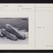
Two standing stones of grey granite, the smaller leaning against the larger, which is set vertically and facing N, measuring 4'2" to 4'5" in height and 7'3" in girth at base. The smaller stone measures 3'5" in height and 5'10" in girth.
Supposed to be the remains of a stone circle or boundary stones of the ancient thanedom of Buchan (A Ranken, Episcopal minister, Old Deer).
Name Book 1870; F R Coles 1904.
The smaller of these stones is prostrate, with one end suported by a field clearance boulder. The other stone is still earth-fast but leaning over at a steep angle and kept from falling by the prostrate stone. No evidence of a stone circle.
Resurveyed at 1:2500.
Visited by OS (RL), 27 April 1972.
(Site of Regional Significance: location cited as NJ 9896 4128).
NMRS, MS/2059.

