

Ilkley Moor is home to an estimated 300-400 carved stones, the majority of which are home to numerous carvings of cup and rings and petroglyphs, over the years some of the stones have been lost to quarrying whilst others are still waiting to be discovered, as they lay, unearthed and covered in moss and soil, as they have done for thousands of years. Surviving examples of rock art in the British Isles are believed to represent only a small sample of that which had been produced in the Neolithic and Bronze Ages. Many examples of petroglyphs would have eroded away, thereby being lost to contemporary scholarship. In other examples, images might have been painted onto rock, or marked onto less permanent surfaces, such as wood, livestock or the human body, thereby also failing to survive into the present.This walk I’ve devised is both short and interesting, it only covers a distance between 2 and 3 miles on roughly the western side of the moor. It’s certainly not a difficult walk and there are easily followed footpaths between the carved stones, the terrain is outstanding and, other than the stones, it’s full of surprises, I’ve seen wild deer, dead sheep and even a brand new shovel and pick axe which seemed to have been abandoned.
The route is a horseshoe which starts and finishes on Keighley Road, adjacent to the footpath for Silver Wells, where, the tarmacked road surface terminates and it becomes a track, there is available car parking for about 4 cars with roadside parking available if necessary.
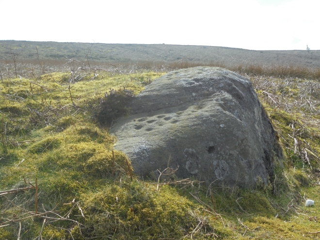
The first stretch of the walk in a south-easterly direction leads to the first find of the day, and, what I can only describe as the least interesting of any of the day’s discoveries, it’s both unnamed and easily missed, it was only a stroke of luck that I noticed it, plus the fact that it stands on the footpath I was following. The stones are notoriously difficult to find, and, without a 10 figure grid reference reading on the GPS, well, such as this one, would be virtually impossible.

On this unnamed stone, I could see maybe six cups and no rings, whether this was due to weathering and erosion or there were no rings cut, I don’t know, but, a find is a find, and this was a great start to the day. It’s fair to say, due to the stone lacking as much interest as many of the others in regards to its surface, that may be the reason it has no name and remains nothing more than a chronological number on the moor’s finds list, but, this really is the least interesting on the route, they really do improve with quality as progress is made.

Following the route and GPS leads to the second stone and, in my opinion, one of the best I’ve ever discovered, the Barmishaw Stone which, due to the winter terrain, was so much easier to find than it was initially when I discovered it during the summer, then, it stood hidden and surrounded by deep and thick ferns, when, although it stands close to an ancient track, it remained completely hidden to view.
This stone is home to some of Ilkley Moor’s speciality carvings, ladders, which consist of parallel grooves linked by perpendicular ‘rungs’, which, so far are unique to this and the Panorama Stone. As with many of the moor’s carvings, these seem somewhat difficult to see, (weather depending), but if my research is correct, there are 6 in ladder form and 24 cups, 9 of which have rings.
About half a kilometer away, heading WNW, was the next port of call, the Willy Hall Stone, which, is situated in Willy Hall’s Wood, who was Willy Hall? Whoever he was, the location which bears his name is believed to have once been a very sacred spot, and, it’s easy to see why whilst you’re there. The stone is on a mound which is surrounded by 2 streams which drain off Green Gates and rejoin one another at the bottom of the mound at Willy Hall’s Spout. The stream then takes route into Ilkley, under Brooke Street where it joins the River Wharfe near the bridge close to where the Roman fort of Olicana once stood.


As I was close to the Willy Hall, I met a hiker, he was doing a horseshoe route and heading back to his destination, (the Cow and Calf pub being his half way point and return), we had a little chat, he was telling me, how, he’d forgotten his compass but felt comfortable with his map, knowing where north was, and, with his experience, he felt comfortable following his route. He told me he was on the Millenium Way, sadly, he wasn’t, he was on a track about 100 yards above it. I’m not criticising him at all, he wasn’t far from where he thought he was, he wasn’t lost and he was heading in the right direction. But, he told me he was ‘old school’ and confident with nothing more than his map. I didn’t challenge him, nor did I criticise him, but, I don’t agree with his thinking. I’m a believer of using every piece of modern technology which exists. Finding these stones without a 10 figure GPS reading would, with some of them, be virtually impossible, plus, I know exactly where I am in any weather or condition, and, as yet, I have found every single stone and carving I’ve been looking for, in my opinion, if the technology is available, use it, not only do you know exactly where you are, in ANY weather condition, but so do the Mountain Rescue, should you need to contact them, (so long as you have a phone signal), modern technology is a life saver.
After discovering the Willy Hall Stone, realising I had walked past in on numerous previous occasions, and, like many others, being completely unaware of the wonderful carvings adorned upon it, I took a south-westerly route in search of the illusive Pitchfork Stone. My route was nothing more than a short horseshoe, starting and finishing at the same point, although there were other carved stones within the area, I hadn’t included them, it was simply a basic route I’d devised with some interesting features along it. Finding the Pepperpot was a first, I’d only read about it and never seen it. It’s only a few yards from another ancient trackway and another wonderful discovery. On display are an estimated 50 cups on its upper part with another 17 on its lower part, well, how many more lay beneath the moss which covers over a third of the stone which is covered in moss, it needs removing, regardless of some may disagree, I’m a great believer the removal of the moss will reveal more, and, the acidic soil erodes any potential carvings at a faster rate than exposure to daylight and weathering does, it makes sense to remove the moss. Once at the wonderful stone, there’s very little dispute to why it received the name it has.


For the sake of practice, I took a map and compass bearing for the next stone, the Pitchfork. on the horizon, a stone seemed prominent, it matched the bearing, so, towards it I headed, on what seemed, the longest empty stretch of my route. I didn’t stay on the footpath which ran adjacent to some wonderful woodland for long, I headed into the wild moorland in the direction of the prominent stone, believing, in my own ability that I would easily find the Pitchfork, not that I had any idea of what it looked like. The south-westerly hike gave me plenty of time to ponder over the 2 roe deer I’d seen earlier, those wonderful animals roaming free on the open moorland, pure eye candy, unlike the decomposing sheep I’d seen earlier, (I’d have taken its skull as an ornament had it not been full of brain tissue).
The Pitchfork is situated on the brow of the hill, an exposed area, close to a footpath but on the wild and windy moorland, it certainly wasn’t the large and prominent, isolated rock I’d imagined it to be on my compass bearing, far from it, it was hidden and very difficult to find, but, eventually, find it I did, I was stood on the stone before I saw the carving, this one is a tester for anybody to find, the buzz of finding it was a pure highlight, and, it stands on an alignment with other unmarked stones, another puzzle for potential explanations to their meanings?


The above photo was taken at the GR reference I had found, the cup and ring carving is absolutely wonderful, but, I did question why on earth it took the name Pitchfork, I questioned it, but, left it there. It really is a wonderful cup and ring carving, an absolute gem, but, having since researched the stone for information regarding it, I discovered that this stone, isn’t the Pitchfork as I’d previously being led to believe, it’s a wonderful stone and carving but not the one I’d come in search of.

Having believed I’d found the Pitchfork, I headed towards my next one, one of the moor’s most famous and visited, it even has a bench for tired walkers located close to it.

This is probably one of the most impressive carved stones on the entire moor, this photograph wasn’t mine, the daylight made mine worthless by comparison, so, I have used this as a replacement, a far superior one. Over a metre high and 3 metres in length, it has over 95 cups, rings, interlinking grooves and gutters, and, an incomplete swastika.

It’s worth bearing in mind, the swastika, as it’s remembered today, was a negative symbol corrupted by Hitler in the 1930’s and since then has been revered. Sadly, it will never be seen as anything other, but, prior to that dark period in the 20th century, it had a positive meaning and in some parts of the world, it still has. This carving predates Nazism by a few thousand years, so, it should be respected, as all the other carvings, as nothing other than it was intended, a symbol of good fortune and hope for all.
There was more than a touch of irony as I headed for my 7th stone after leaving this wonderful piece of rock art, the weather was changing for the worse, a black cloud was heading over from the east, the temperature was dropping and I could sense rain wasn’t far behind. The Neb Stone was my next destination, a welcome descent from the bleak and windy plateau I’d been covering for the previous hour.

The Neb Stone is more of a landmark stone than any other, although there are a few possible cup carvings on its surface, maybe the Neolithic inhabitants deemed it unworthy of their handy carving, we’ll never know, but, like many others surrounding it, this prominent stone is both interesting and worthy of a visit. As I approached the Neb, whilst crossing the tracked part of Keighley Road, there were 2 female German tourists heading down the road towards Ilkley, we said hello and they asked if they were on the correct road for the town, I told them they were and, after observing their shoes and clothing, encouraged them to make haste their descent into town, the rain was very soon to dominate the day, and, they certainly weren’t prepared for it, like anywhere in the hills and fells, even on a warm day, it’s essential to prepare for a change in the weather, at the very least, some waterproof clothing, sturdy shoes or boots and, no denim jeans, these two weren’t prepared and, unless they hurried, would feel the full force of the oncoming storm.
My final stone, and my 8th of the day was a particular friend of mine, not only am I responsible for removing the moss both from its surface and around its edges, which revealed more hidden and buried carvings, it was the last place I spent some time with Wendy before her sudden death, she was my former partner, my son’s mother and without doubt, my best friend. She joined me on my last visit and helped me finalize the cleaning of the stone, so too did she find what I believe to be a stone axe head, something I still need to be checked out by the experts, she was in her element in a pair of hiking boots and up to her knees in a muddy field, she was a legend and she is deeply missed.

Located on Weary Stone Hill, this stone demands views over the Wharfe valley towards Bolton Abbey and Great Whernside. Prior to it being cleaned and having the surface moss removed, more than half of the surface was buried by it, there were 12 cups and some rings visible, since it’s cleaning, there are now at least 4 more cups clearly seen. Removal of the acidic peat moss not only reveals the hidden carvings, it prolongs their lifespan, it appears that the soil and moss erode the stone at a faster rate than being exposed to the elements would.
So, having completed this horseshoe walk at the wonderful Weary Stone, the circular walk was now completed with only a hundred yards to go to the car. It’s not a difficult walk with only one ascent, the difficulty is finding the appropriate and correct stones, one of which failed me as I had an incorrect grid reference number. Still good fun and a wonderful way to spend a full afternoon, I recommend it to anyone, don’t forget the correct clothing, map and GPS.

Dedicated to Wendy Joanne Barnes – 1/12/1966 – 25/11/2017

Well done Dave…
Interesting article, I really enjoyed the read… 😊 It looks like a great walk… photos were fascinating!
Thank you.
LikeLiked by 1 person
Thanks for your wonderful comment, it’s great fun searching these gems out, they’re all over the place in and around the Ilkley area, loads more to discover 🙂
LikeLike
Dave, thanks so much for this walk. It has really inspired me to go looking for the carved rocks and been great fun. Please can you explain how to find the Weary Stone though, it has defeated me and the friend who tried to find it as it did not seem to be at the grid reference!
LikeLike
Hi LS, sorry to hear you missed the Weary Stone but it is hidden by the surrounding vegetation but very rewarding once discovered. The GR Reference is 10617 46586 and it’s about 20 – 25 yards ascent from the footpath, good luck next time because it’s a very rewarding find.
LikeLike
Hi Dave, thanks for your fine article. Living nearby I will enjoy doing the walk and exploring the stones. However, despite trying several websites, I have been unable to find a way of converting the grid references you have provided into latitude/longitude coordinates for entering into my Google Earth saved waypoints. Your guidance on how to do this would be much appreciated.
LikeLike
I am afraid I only work with grid reference points so I don’t knowing how to convert them, they do work on my Garmin GPS and probably others if you have one?
LikeLike
Hi. I came across this walk on Ilkley Moor and saw your comments. One of the sites I’ve used is nearby.org.uk which works for me. I’ve input the coordinates for the Weary Stone in the link below.
http://www.nearby.org.uk/coord.cgi?p=SE1061746586&f=conv
And it works!
LikeLike
Good luck, I need to get up there again soon it’s superb. Be warned, the wonderful Weary isn’t prominent and can be easily missed.
LikeLike