
Richland Historic District (Richland, Georgia)
Richland Historic District | |
_(c._1890)_(Richland,_GA).JPG) Built in the late 1800s and renovated in 2008, the Richland Depot now serves as Richland's City Hall. | |
  | |
| Location | Roughly bounded by Ponder, Harmony, Broad and Olemen, and Wali Streets, Richland, Georgia |
|---|---|
| Coordinates | 32°5′27″N 84°39′45″W / 32.09083°N 84.66250°W |
| Architectural style | Late 19th And Early 20th Century American Movements, Late 19th And 20th Century Revivals, Late Victorian |
| NRHP reference No. | 86001021[1] |
| Added to NRHP | May 5, 1986 |
The Richland Historic District is a historic district in Richland, Georgia that was listed on the National Register of Historic Places (NRHP) in 1986.[1] It includes the historic commercial center of Richland and residential areas around it. Architectural styles of houses, commercial buildings, and institutional buildings in the district include Greek Revival, Victorian Eclectic, Neoclassical, and Craftsman/Bungalow.[2]
The district includes the Smith-Alston House, which is separately listed on the NRHP.
Contributing Properties[edit]
-
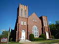 Richland First Baptist Church (c. 1912)
 -
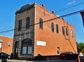 Peoples Bank (c. 1905) is located at 106 Broad St. Now used as the offices for the Stewart-Webster Journal.
 -
 Henry Audulph House (c. 1842)
 -
 George Lunsford House (c. 1899)
 -
 Arthur A. French House (c. 1914)
 -
 M.P. Wall House (c. 1922)
.JPG)
_(Richland,_GA).JPG)
_(Richland,_GA).JPG)
_(Richland,_GA).JPG)
_(Richland,_GA).JPG)
_(Richland,_GA).JPG)
References[edit]
- ^ a b "National Register Information System". National Register of Historic Places. National Park Service. March 13, 2009.
- ^ Carolyn Brooks (February 21, 1986). "National Register of Historic Places Inventory/Nomination: Richland Historic District". National Park Service. Retrieved September 4, 2016. with 59 captioned photos from 1985
| Topics | |
|---|---|
| Lists by state |
|
| Lists by insular areas | |
| Lists by associated state | |
| Other areas | |
| Related | |