• We have updated our Community Code of Conduct. Please read through the new rules for the forum that are an integral part of Paradox Interactive’s User Agreement.

AirikrStrife

Bergakungen
20 Badges
Jul 30, 2010
2.292
1.827
  • Europa Universalis IV: Art of War
  • Europa Universalis IV: Conquest of Paradise
  • Europa Universalis IV: Res Publica
  • Europa Universalis IV: Mare Nostrum
  • Europa Universalis 4: Emperor
  • Imperator: Rome Sign Up
  • Europa Universalis IV: Golden Century
  • Europa Universalis IV: Dharma
  • Europa Universalis IV: Rule Britannia
  • Europa Universalis IV: Cradle of Civilization
  • Europa Universalis IV: Third Rome
  • Europa Universalis IV: Mandate of Heaven
  • Europa Universalis IV: Rights of Man
  • Crusader Kings II
  • Europa Universalis IV: Cossacks
  • Europa Universalis IV: Common Sense
  • Europa Universalis IV: Pre-order
  • Europa Universalis IV: El Dorado
  • Europa Universalis IV: Wealth of Nations
  • Europa Universalis IV
So not long ago I did make a suggestion on Tibet, here comes a much updated thread on the matter with more detail and historical accuracy. All drawings I done myself are just rough pointers and in not accurate.
Representing semi-tribal regions like Tibet accuratly is not possible, in fact, only the region of Kham had over 20 different kingdoms at various times. This is a suggestion to broaden the historical accuracy, suggest new provinces and flavor for the region in various ways.
Generally speaking the region had a small population density but at the same time covers an area over 2.5 million square-km big and historical sources notes it as being rich, with trade going over Tibet from India, central asia and China with tibetans being known for exporting gold and horses and buying tea. I think it's justifiable from what I've read that Tibet becomes a slightely richer region with a few extra provinces.

For most of the Tibetan history between unified states, western Tibet would be it's own cultural and political "center". At one point western Tibet, that is roughly the EUIV provinces of Guge and Ladakh, would form a political entity which would then fracture over time, reform, fracture und so weiter. Occasionally Western Tibet would be conquered by Mongols, be at war with central Tibet or with Kashmir but for the entire EUIV timeline there would be at least one independent kingdom in Western Tibet.

Western.Tibet-.jpg


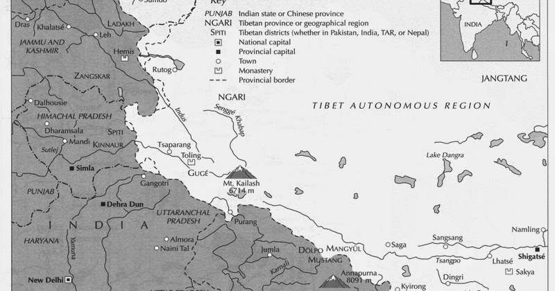
My first suggestion concerns an increased amount of provinces in the region, it should be mentioned that all of the Kashmir region/northwestern India could do a bit of a redrawing, most notably the EUIV province of Baltistan does only barely correspond the historical province of Baltistan, as can be seen in this map:
Jammu-and-Kashmir-map-new-No.1.jpg


but I will only focus on Tibetan areas.

Ladakh should get Tibetan culture and be split in two provinces, with Zangskar (at times an independent kingdom). Zangskar should also take some land from the Himalaya wasteland province corresponding to the Lahul and Spiti valleys under Ladakhi influence https://en.wikipedia.org/wiki/Lahaul_and_Spiti_district
Also information on the Guge kingdom: https://en.wikipedia.org/wiki/Guge
I find it more reasonable that Ladakh has Tibetan culture due to it not only being a Tibetan language spoken in the region but also adherence to Tibetan Buddhism and the close political and cultural network of western tibet. Baltistan as having been converted to islam could better be represented with an Indic culture. Besides the political conquest of Ladakh would be more within the west tibetan sphere rather than northwest indian as can be seen in Ladakh at it's height.
Ladakh.jpg


Tibet, West.jpg

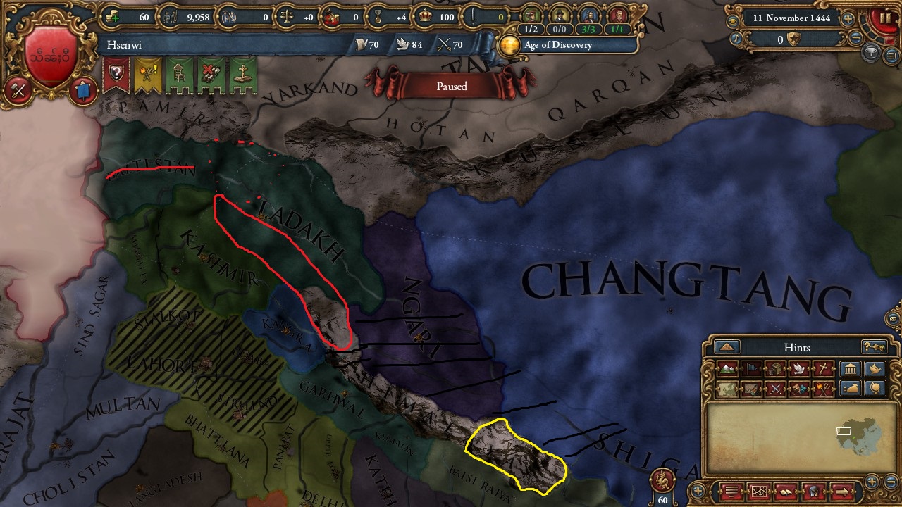
Red areas circle roughly the proposed province of Zangskar, dotted circle is a rough localisation of the actual Baltistan with remainding territory better being an independent state (Gilgit)

The Black stripes indicate areas which should be under control of the Guge kingdom. Which I suggest being split into two provinces (with some territory being taken from Shigatse, possible some parts of Changtang) and the Kinnaur district of modern India in the Himalaya range to create a border to Garhwal), with many choices of what to call them. Ngari more correctly being the northern part of the current province would remain with a new province using any of following names: Guge, (Mangyül) Gungthang or Puhrang/Burang. All refering to different kingdoms/regions within the west-tibetan political sphere.
https://en.wikipedia.org/wiki/Mangyül_Gungthang
While the Gungthang kingdom was independent in 1444, using the Gunthang as a guidline for the province would allow the Ngari province to remain unchanged. Guege/Burung are basically interchangable and would be centered in southern Ngari province

Last the Yellow circle refers to the Kingdoms of Dolpo and Lo united into one independent kingdom of Lo
https://en.wikipedia.org/wiki/Dolpo
https://en.wikipedia.org/wiki/Upper_Mustang (with a picture of the Lo flag)
While Lo was a small and fairly isolated kingdom, it was a major transhimalayan trade link and it will provide a better connection between Nepal and western tibet, after all the Khasa kingdom of central Nepal did at one point conquer Guge without going through central Tibet.


Also there were gold being mined in western tibet so I suggest the new province in Guge, whatever it'd be called produces gold

All in all that is three new provinces into Tibet and Ladakh changing culture (in case nothing else is done with the Kashmir region). I suggest a slim boost to the capitals of Guge and Ladakh giving them atleast 4 development each. Starting off Ladakh with 10 development and Guge with seven (Lo will suffice with 3). Furthermore Guge and Ladakh should have missions relating to reuniting western tibet and gain claims upon each other. The changes also includes more accessability in the region, maintaing the unique defensive position of Tibet but making it more dynamic.

Tibet, South.jpg


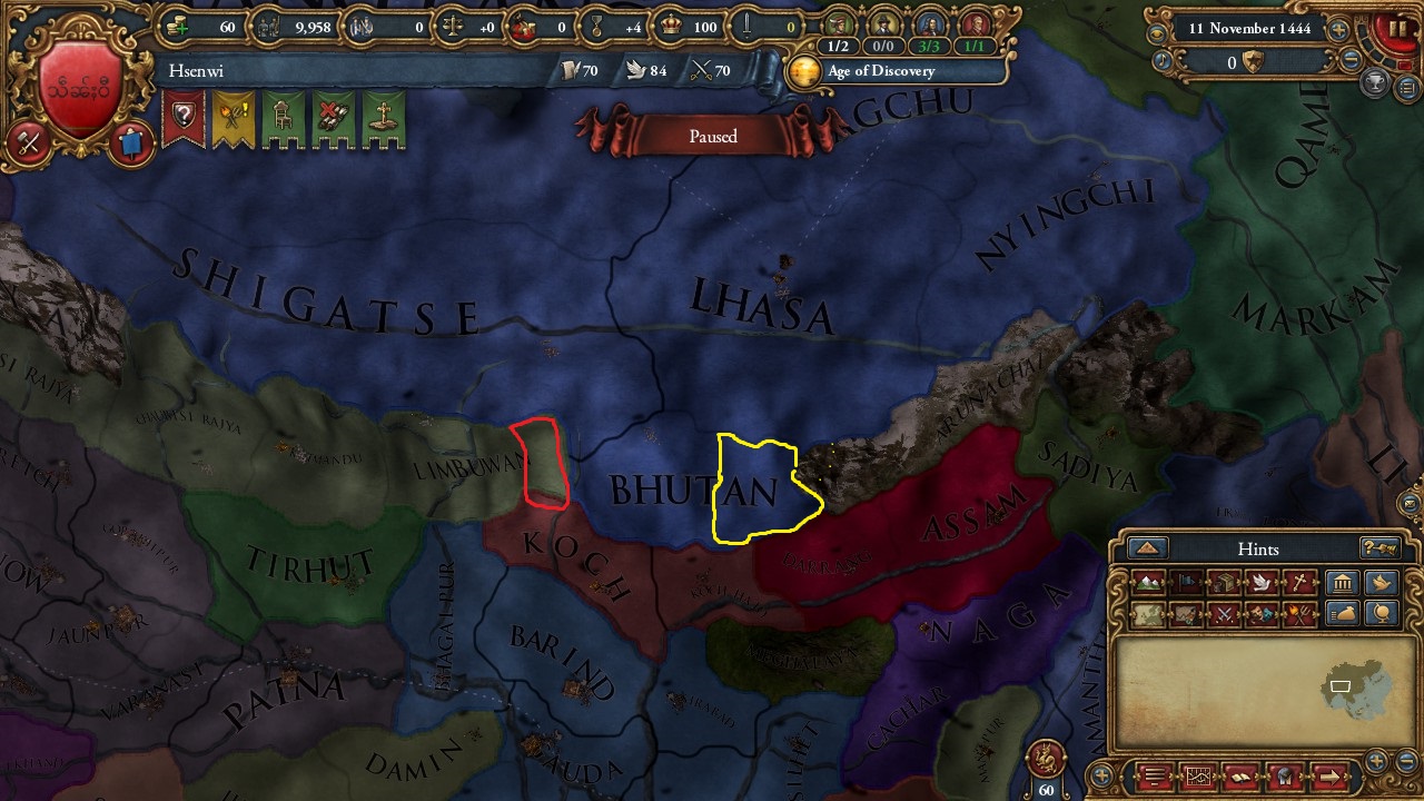
First of the paradox got the areas wrong, if nothing practical in the game is changed, at least the names should be switched with Ü being the central area around Lhasa and Tsang being the west.

Mainly working to split Bhutan into new provinces so that Bhutan is no longer part of the Ü-Tsang area and can form it's own area. Red circle denotes the future independent kingdom of Sikkim with Darjeeling hills in India which would be part of Sikkim until the late 18th century.
https://en.wikipedia.org/wiki/Sikkim
https://en.wikipedia.org/wiki/Darjeeling_district#History

Yellow circle is the Bhumthang kingdom, one of the largest kingdoms in eastern Bhutan before unification in the 17th century: https://en.wikipedia.org/wiki/Kingdom_of_Bumthang
These two new provinces would reasonable be poor (3dev) and start with high autonomy comparably to what Bhutan starts with.
Furthermore Gold were produced in central Tibet (Ü), I can't say exactly were but it was a major source of revenue for the central goverments in Tibet, but I suggest placing the mine in Nagchu (a 3 dev province)

Tibet East.jpg

map_022_front_100ppi.jpg

202_kham_culturalarea_1500px.jpg

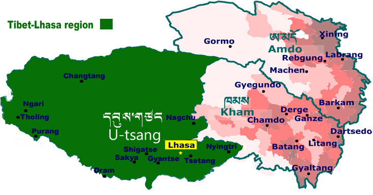
As I mentioned in the begining, Kham wasn't a united kingdom nor where Amdo part of Kham or a united Kingdom. It is ard even to assert exact borders between the three main regions of Tibet. Nevertheless I tried making more sense of the area. I keep Kham as a kingdom but add AMdo as a new independent kingdom starting as a ming tributary representing the kingdom of Choné (much like the kingdom of Dege is used to represent all of Kham)
Details about the Choné kingdom can be read at this page:
http://places.thlib.org/features/24353/descriptions/81?frame=destroy

To get some more detail out of the region there are a few things that should be noted. The center of the kingdom of Choné is slightely southeast of Xining, https://en.wikipedia.org/wiki/Jonê_County
Meaning a new province needs to be carved out partly from chinese territory. The region in question is reffered to as Tewo on the map of eastern regions provided. The goal ought to be a smother eastern border for Tibet taking into consideration Xining and Songqu as part of "Tibet"

Furthermore, while exact borders are vague, sources I looked at has been clear that the city of Gyegu and surrounding is part of Kham rather than Amdo, so I would keep that province in Kham and either make a new provinces in the east, or let the remaining territoy be divided by Changtang and Amdos other provinces.

The division of areas could be solved with A new area called "Hor" taking three northernmost regions of Kham.


What is the connection between Tibetans and Burmese people? distant related language? different version of Buddhism? There are no close relationship between any of the Tibeto-Burman languages in the game that would have any regocnition between speakers of the different languages. There are also vast geographic distances, and very different cultural spheres. I suggested an overhaul of Southeast asias smaller cultures before the last patch https://forum.paradoxplaza.com/foru...g-at-south-east-asian-culture-groups.1004122/
But would go on to update that. I don't know much about Yi or Dali cultures, which direction they would most logically fit in, with tibetan, burman or chinese
Tibetan however, I now suggest becomes it's own culture group (called Bodish) To understand Tibetan diversity this article is a good start: http://places.thlib.org/features/5226/descriptions/5
Essentially "Tibetan" is not a coherent group of people but rather better compared to something like EUIV's south slavic (since it come to include non tibetan speaking peoples like Qiang peoples in Kham). The cultures of the Bodish group would be: Tibetan (In Ü area and Shigatse), Kham (in Hor and Kham area) Amdo (In Amdo area and Songqu) Ladakh/Bhotiya in Ladakh/Guge provinces of western Tibet and Dzongka/Bhutanese for the Bhutan area, (Changtang and Lo get's either Ladakh/west or Tibetan/central)

As I can't come up with how events should work, but in Tibet at the entire EUIV timeline there where serious rivalry between different sects of Tibetan Bhuddism. Historically speaking this was nothing new in itself but in the 15th century a new sect arose called Gelug (commonly known as yellow hat sect) which came to be dominant in Tibet (Dalai Lama is the Gelug leader) https://en.wikipedia.org/wiki/Gelug and the older sects are commonly known as Red hat sect https://en.wikipedia.org/wiki/Red_Hat_sect. War and conflict between on the other hand dominant Gelug against the older sects would be a constant element of Tibetan politics throught the whole era with different princes and monasteries supporting different sects. (For simplicity only using red hat and yellow hat is enough)

This is there this excellent suggestion will be good to point to https://forum.paradoxplaza.com/forum/index.php?threads/lets-make-1-21-the-mongolia-patch.1012148/
And see a Tibet overhaul as part of a larger Mongol overhaul.
Mongols from Kubilai Khans era until today has variously seen Tibet as their spiritual beacon, ensuring several tibetan lamas prominent positions in Mongol culture
Including Phagpa https://en.wikipedia.org/wiki/Drogön_Chögyal_Phagpa who were spirutal advisor to Kubilai Khan
The third Dalai Lama who converted Altan Khan and mongols to tibetan Buddhism https://en.wikipedia.org/wiki/3rd_Dalai_Lama
The fifth Dalai Lama who with the aid of Güluk Khan became king of Tibet and ruled over Tibet with the Mongols: https://en.wikipedia.org/wiki/5th_Dalai_Lama
There is a lot of interesting history to build from to create flavor events and to encourage mongol interest in Tibet.

What are the thoughts of east asia enthusiasts? @Warial @JKiller96 @Semi-Lobster
 
Last edited:
Upvote 0
Historically speaking, in this region Turfan was ALSO a tributary of the Ming and gifted the Chinese with much needed horses. The Ming sent two expeditions to force the Turfanese, of which, of which, only one of 2300 Chinese and Mongols in 1495 actually succeeded through force of arms. In the end though the only thing that seemed to work was economic sanctions against Turfan. For the Ming, Hami was a strategic tributary for the Ming, they not only helped control the shrinking but still lucrative silk road trade but was also part of a larger policy to keep the city states small, weak and controllable. Hami was simply too far for the Chinese to send an army and would be too expensive and in the end they were unable protect Uyghur city from Turfan. So much like in game, while it is in China's best interest to stop wars amongst it's tributaries but it doesn't necessarily mean it can or will, perhaps we need use Yumen as a template perhaps from turning areas currently under direct Ming rule into tributaries and direct vassals?

I'm still trying to figure out who exactly the Chijin Mongols were, they had a royal marriage with the Oirats under Esen, but I can't seem to find anything else?

Yes, that's why I suggested Turpan becomes part of Kara Del (not really nerfing Ming's presence in the region -.-)

perhaps we need use Yumen as a template perhaps from turning areas currently under direct Ming rule into tributaries and direct vassals?

huh?

I also tried to find solid information on the Chijin Mongols, but nothing yet
 
I think what needs to happen is Chagatai needs to lose a few provinces, Turfan and probably to Qakilik, to form a new Sultanate country tag. The mid 15th century in this region is very fluid though, and it's hard nail down information on the cities in the Tarim Basin, especially after their forced conversion to Islam beginning in the late 14th century in English at least.

As for what I mean by Yumen, I mean that being designated "Wei", or "guards" by the Ming did really mean the areas were part of China-proper yet but seem more that they were designations for far-flung ethnic groups to be nominally under Ming's sphere of influence with minimal upkeep or repopulation. The same can be said and applied to areas under "tusi" (local king) leadership, where they are more integrated into the Chinese sphere politically than a tribute like the Ryukyu Kingdom for example but not necessarily under direct control of the Ming court and still had more or less free reign to declare wars, enter royal marriages and had their own laws, rulers and customs outside of Chinese investiture, whom were more concerned with security and tribute rathern than direct control such as a prefecture (zhou) or sub-prefecture (ting). Hopefully I'm not stirring the pot too much, but perhaps one way to balance China, post-Mandate of Heaven is to re-examine what provinces should be Chinese?
 
I agree that Yumen should by the same reasoning as Kara Del or Sarig Yogir be part of an independent tributary of China rather than a chinese province. Considering how hard China protects it's tributaries though, it really doesn't help anyone else, especially of Qakalik becomes part of a Ming tributary that would mean a Ming block in the far west almost impossible to go around.


Yeah, I was into the idea of looking through Tusi's aswell. This article is fairly informative of the general status of Tusi's on the frontier: http://www.thlib.org/places/politie...es.thlib.org/features/23673/descriptions/1281
I don't know if that merits making the Naxi kingdom in Lijiang an independent ming tributary.

I do argue that the Ming province roughly conforming to the Choné kingdom should start as a tributary to Ming aswell.
http://www.thlib.org/places/politie...aces.thlib.org/features/24353/descriptions/81

About other Tusis, perhaps some other provinces should be looked at.

The problem however is that even letting china go of a few provinces, the total loss of dev will be minimal to China, they still have the states as tributaries meaning a small trickle of tribute aswell as making the mandate go up faster. But more importantly it doesn't make it easier to Expand around the Mingsphere.
So far the best suggestion to keep Ming at bay is the big Mongol monster we've been talking about in the other thread, like the risk of China getting to fight a dozen hordes at once over a vast steppe area would be extremely dangerous for Ming.
 
Translation of Japanese Wiki article said:
In 2nd year of Yongle era (1404), Dalini (㙮力尼), a son of Chancellor of Northern Yuan Ruomu (若木) led 500 remaining retainers from Halatu (哈剌禿) to submit to Ming. Emperor Yongle in response created Chijin Mongol Office of 1,000 Households (赤斤蒙古千戸所) and enfeoffed Dalini as a Mingghan (千戸長). In 8th year of Yongle era (1410) the Chijin Mongol Office was promoted to Chijin Mongol Guard (赤斤蒙古衛) and at the same time as Mingghan Dalini was promoted to Commander (指揮僉事), his Amirs (百戸長) were promoted to Mingghans and took Chinese names. In 9nd year of Yongle era (1411) Dalini brought tribute to the Ming court together with Shazhou Guard Commander Kunjilai.

In 10th year of Yongle era (1412) Lao Dihan (老的罕) revolted against Ming and escaped to Chijin Mongol Guard, where he was hidden by Dalini. Hearing of this, Emperor Yongle gave an order to Count of Fengcheng Li Bin (豊城侯李彬) to suppress Chijin Mongol Guard. however, Li Bin and Yang Song (楊栄) reported "Because currently we have winter soldiers are not fit [to battle]. Also even though men who commited sin are numerous, if the army is moved won't also sinless people be harmed?" and fervently opposed military action. At that time Yongle changed [order] and dispatched envoys to Commander Dalini, demanding to give up Lao Dihan in exchange for a hefty reward, but threatening with military action in the case of refusal. Next year (1413) hearing Yongle's command, Dalini arrested hiding Lao Dihan and send him to Beijing. In exchange for his merits Dalini was promoted to a higher post (指揮同知), while his Mingghans were each promoted to (正千戸), collectively being bestowed higher ranks.

In the first year of Xuande (1426) Sunanshujia took over the command over Chijin Mongol Guard and dispatched envoys with tribute to Ming. Upon receiving the tribute Xuande promoted Sunanshujia. Next year (1427) Mingghan of the Chijin Mongol Guard Sai Fuding (賽夫丁) arrived with the tribute. Yet zgain in 3rd year of Xuande (1428) in exchange for assisting Ming envoys dispatched to Timurids and Moghulistan, Shazhou Guard and Chijin Mongol Guard were bestowed [rewards]. In 5th year of Xuande (1430) they send tribute to Ming court along with the chieftain of Mekrin tribe Monghke Bukha and Injilai of Shazhou Gaurd, for which they were bestowed with rewards.

In 7th year of Xuande (1432), when Ming envoys were once again dispatched to Timur's realm they were escorted (by the guard). During that time yet another succession occured and sons of the vice-commander (指揮僉事): Toqtogha (脱脱) and Ilubei (亦魯伯); succeeded their father. In the autumn of the same year, a military officer dispatched by Ming from Suzhou (肅州) was killed during reconnaissance mission. Governor of Suzhou Wang Gui (王貴) suspected that this was an action of Chijin Mongol Guard and send a report to the court in order to punish perparators, while at the same time, he cracked down on Chijin Mongols doing private trade with the court. After that envoys from Chijin Mongol Guard, who returned to Ming, reported that it was in truth Wang Gui who acted injustly and so promptly he was arrested [by Ming].

In the first year of Zhengtong (1436), in response to the request of Commander of Chijin Mongol Guard Sunanshujia his underlings Cang Erji (倉児吉) and Sheng Ji (省吉) were promoted at their posts. In the same year Mingghan of Chijin Mongol Guard Ba Duma (把都麻) became a chief of a rebel band. Tributary missions to Ming continued normally while Commander Sunanshujia send Toghon Temur and Monghke Bukha to suppress [rebels]. They were promoted for their merits.

You guys were asking for some information on Chijin Mongols. This is my translation of Japanese wiki article on them. Unfortunately it refers only to relations between them and Ming and only for first 32 years. There's a lot more information in Mingshi, but that would take me far more time to translate, so I won't promise anything (and I don't have access to annotated Japanese translation).
 
I have continued to research Tibet and studied the different maps I found and have updated my suggestion. I'm uploading new, modified maps of the region as I suggest it should be drawn (maps I've used are spread out a bit throughout the thread as well as sources)

Tibet väst 2.jpg

New map of western tibet
Legend:
Black circle: Baltistan, should become an independent country together with the province named Baltistan (should be renamed Gilgit) Country Baltistan, religion: Shia culture: Bhoti in Baltistan and Kashmiri in Gilgit.
Baltistan were no longer part of Ladakh and had become an archrival
Grey circle: Ladakh (country Ladakh)
Dark Red circle: Zanskar [includs Lahul and Spiti] (country Ladakh)
Red circle: Ngari/Ruthug (country Guge)
Yellow circle: Guge/Purung [produces gold] (country Guge)

I'd argue these five provinces (Baltistan, Ngari, Guge, Ladakh, Zanskar) all form one area (western Tibet/Ngari, part of tibetan region), Kashmir area would need some reshuffling then. I also argue these five provinces should get their own culture, since Ladakhi doesn't really fit all of them, Bhotiya is more representative. I argue this based on shared culture, history and political influence.

Pink circle: Mangyül (really an independent country variously under Guge and Tsang influence. At the moment I argue to keep it with Ü-Tsang for the sake of balance)
Green circle: Mustang/Lo (independent kingdom, province includes kingdom of Dolpo)
Mustang and Mangyül would have Tibetan culture

Tibet Central 3.jpg

There are some unresolved issues in my mind since the borders between Kham and the Ü area and Amdo are not clearly defined with map showing different borders. Roughly speaking though, the current Kham area is undersized. Big Red Circle represents maximum extent of Kham area, (Nagchu town is just on the border of the area with most of the province within Kham/Hor sphere so I choose to include it in Kham) Red circle includes all provinces that should have Kham culture, the set up I am now suggesting is making provinces west of the yellow line part of a new state (Somewhat anachronistically using the Hor name for the whole area) This will also constitute a new area named Hor. Orange circle represents new province based on the Powo kingdom: http://www.thlib.org/places/politie...es.thlib.org/features/23676/descriptions/1284

Lijiang province should get Kham culture, but remain with Ming or become a tributary kingdom of Ming: Naxi Kingdom.
http://www.thlib.org/places/politie...es.thlib.org/features/23673/descriptions/1281

EDIT: Seeing Nangchu as part of Ü-Tsang could be realized with giving most of the province present territory to the Powo province, and then expanding it into the Changtang province.
EDIT 2: Counties inhabited by Khams speakers http://www.thelandofsnows.com/kham/the-tar-part-of-kham/ including Nagqu

Green cricle is a proposed new province for Ü-Tsang, Lhoka. Based on Lokha prefecture and the Yarlung valley (could be producing gold).

I haven't done any changes to southern Tibet; Sikkim, Bhutan, Bumthang since OP. Still argue they should have there own culture (since this would represent about a dozen different peoples it's hard to choose an appropriate name so I'd just go with Ngalop for all)

tibet öst 2.jpg

Green circle would be Gyermu/Golmud, starting off as an uncolonized province, and then later through an event be settled by mongols/oirats. I write about that in a previous post. Yellow represent Golok, red Choné and blue Rebgong. Three provinces constituting the Amdo kingdom. All marked provinces should start with Amdo culture
 
Last edited:
I agree that Yumen should by the same reasoning as Kara Del or Sarig Yogir be part of an independent tributary of China rather than a chinese province. Considering how hard China protects it's tributaries though, it really doesn't help anyone else, especially of Qakalik becomes part of a Ming tributary that would mean a Ming block in the far west almost impossible to go around.


Yeah, I was into the idea of looking through Tusi's aswell. This article is fairly informative of the general status of Tusi's on the frontier: http://www.thlib.org/places/politie...es.thlib.org/features/23673/descriptions/1281
I don't know if that merits making the Naxi kingdom in Lijiang an independent ming tributary.

I do argue that the Ming province roughly conforming to the Choné kingdom should start as a tributary to Ming aswell.
http://www.thlib.org/places/politie...aces.thlib.org/features/24353/descriptions/81

About other Tusis, perhaps some other provinces should be looked at.

The problem however is that even letting china go of a few provinces, the total loss of dev will be minimal to China, they still have the states as tributaries meaning a small trickle of tribute aswell as making the mandate go up faster. But more importantly it doesn't make it easier to Expand around the Mingsphere.
So far the best suggestion to keep Ming at bay is the big Mongol monster we've been talking about in the other thread, like the risk of China getting to fight a dozen hordes at once over a vast steppe area would be extremely dangerous for Ming.

Good point, really more tributaries are more useful to the Ming ingame than some volatile, low development provinces. Right now, the only way to build up as a Mongol or Jurchen state is to accept becoming a tributary for a while to annex other tributaries while Ming does nothing, which is pretty game-y and not too historical.

Interesting idea for a Naxi Kingdom as well, tusi can be a delicate situation, I'm not sure, for example if the Miao Tusi should be seen as tributaries or not? Although I guess the introduction of more centralized government with each successive revolt and thrashing by the Ming could be construed as territory removed from the taxable and controllable sphere of the local Miao Tusis to Ming administration, but then again how much autonomy did they really have compared to other "petty kingdoms" under the nominal tributary status of the Ming? It's a very interesting subject that should possibly be delve into more for sure.

You guys were asking for some information on Chijin Mongols. This is my translation of Japanese wiki article on them. Unfortunately it refers only to relations between them and Ming and only for first 32 years. There's a lot more information in Mingshi, but that would take me far more time to translate, so I won't promise anything (and I don't have access to annotated Japanese translation).

Thanks for that Warial! The Tibet thread and the Mongolia thread have become so intertwined now sometimes I don't know which I'm posting in! So the Chinjin were Yuan remnants who submitted to the Ming, thanks for the lead, I wonder what tribe they and the other Yumen/Suzhou Mongols were from?
 
Thanks for that Warial! The Tibet thread and the Mongolia thread have become so intertwined now sometimes I don't know which I'm posting in! So the Chinjin were Yuan remnants who submitted to the Ming, thanks for the lead, I wonder what tribe they and the other Yumen/Suzhou Mongols were from?
We can't really tell. I only know that they rulers were Chaghataids.
 
To make the thread easier to observe I'm uploading most of the maps I have into one post:

202_kham_culturalarea_1500px.jpg
cultural-tibet-3colors_300.gif
Jammu-and-Kashmir-map-new-No.1.jpg
Ladakh.jpg
M32-100ppi.jpg
map_022_front_100ppi.jpg
map_031_100ppi.jpg
map-utsang.jpg
regions_new.jpg
tibet-map.jpg
Western.Tibet-.jpg


EDIT: Just found a whole bunch of new maps
 

Attachments

  • amdo_sm.pdf
    235,9 KB · Views: 15
  • Kham-sm.pdf
    453,7 KB · Views: 21
  • main_map-sm.pdf
    459,7 KB · Views: 20
  • ngari-sm.pdf
    317,9 KB · Views: 14
  • utsang-sm.pdf
    592,8 KB · Views: 14
Last edited:
Good point, really more tributaries are more useful to the Ming ingame than some volatile, low development provinces. Right now, the only way to build up as a Mongol or Jurchen state is to accept becoming a tributary for a while to annex other tributaries while Ming does nothing, which is pretty game-y and not too historical.

Interesting idea for a Naxi Kingdom as well, tusi can be a delicate situation, I'm not sure, for example if the Miao Tusi should be seen as tributaries or not? Although I guess the introduction of more centralized government with each successive revolt and thrashing by the Ming could be construed as territory removed from the taxable and controllable sphere of the local Miao Tusis to Ming administration, but then again how much autonomy did they really have compared to other "petty kingdoms" under the nominal tributary status of the Ming? It's a very interesting subject that should possibly be delve into more for sure.

I don't think Miao tusi would work out, it'd just sit there and generate tribute and mandate to Ming without ever rebelling. Better would be to move Miao from the chinese culture group as to increase risks of rebels. Before 1.20 Ming was dangerous to play with due to high rebel risks and extra costs of maintaining mandate etc. It was hard to maintain such a huge empire. Now I find it too easy both for player and AI.

The most realistic other way to treat tusis would be closer to how colonial nations work, but I feel that's superflous for a handful of small kingdoms in southern china. Though I wish there could be more flavor to it also considering how one can't even make all of china into states.

I like the Naxi kingdom cause it did play like an independent kingdom, it is large enough, and on the frontier making it part of the regional politics and could conquer and be conquered.
 
Perhaps tusi, should be given a different relation to China, more than a tributary, but not part of Ming. I think these areas would make sense to be something China currently doesn't have, Vassals. Tusi kingdoms and Wei (ethnic "Guard" settlements who swear loyalty to China) now have a much closer relation to China but are still independent, perhaps also borrowing the daimyo vassalage system from Japan as well. This would allow for a greater distinction between tributaries and several parts of Ming currently that should NOT be governed directly by Ming.

BTW AirikrStrife, some good news! Paradox just revealed a screenshot of their new map of Tibet!..... for CK2! :V

https://forum.paradoxplaza.com/foru...2-dev-diary-51-the-roof-of-the-world.1021920/

tibet_full.png
 
Well the next obvious step after this is the Mongol homeland! And then after that, probably China itself! The Fall of the Tang Dynasty! The Five Kingdoms and Ten Dynasties! The Rise and Fall of the Liao Dynasty! The Rise and fall of the Song Dynasty! The Rise and Fall of the Yuan Dynasty! The Rise of the Ming dynasty! It could be pretty exciting!
 
Neat! ALthough I don't play CKII myself xd In general though that feels like the better game to represent these kind of decentralized region which can get more accurate through the use of smaller states as can be seen in the extra detail to Nepal, Kashmir and the northern areas.

Anyway, me and Semi-Lobster has had a conversation on the Tibet/Sichuan borderlands. The region was ruled by local tibetan/gyarong kings with Tusi status (native kings subjected to Ming)

Xinan borderlands.jpg


I figured separating the Gyalrong areas (which includes the city of Dartsedo/Tachienlu) as it's own province (yellow circle), owned by it's own kingdom (Gyelrong) starting as a tributary of Ming was a fairly decent solution. Dartsedo was the center of the Chakla kingdom, one of the most powerful Gyelrong kingdoms. The status of the borderlands are a bit opaque at times, but I think this solution is among the better possible ones. Just like Kham and Amdo are used as generic names for clumped together regional kingdoms instead of represented the dozens or so kingdoms, Gyelrong is considered it's own region in the Tibet region and could be used as a template for it's own state, which were comparably tighly knotted culturally and politically.

Some essays on
Gyarong/Gyelrong cultural region with links to an interactive map: http://www.thlib.org/places/politie...search_scope=global&scope=name&filter=gyarong
Shorter essay on the Gyelrong kingdoms: http://www.thlib.org/places/politie...es.thlib.org/features/23680/descriptions/1288
Shorter essay on the Chakla kingdom: http://www.thlib.org/places/politie...es.thlib.org/features/23653/descriptions/1272

@Semi-Lobster have contributed more sources on the topic throughout the thread focusing on the Jinchuan wars in the Gyelrong region

The western chunk of current Tachienlu would become the province of Lithang (blue) possibly southern parts of the province could together with northern parts of Jianshang form the province of Muli (red).
 
Those are great looking! And they're surprisingly not too small to click either! Songqu and the rest of Garze could be added to the new state as well. Right now the state Songqu is in is this super weird looking one that looks awful. So the new suggested provinces are:
Red: Muli
Blue: Lithang
Yellow: Dartsedo

Fantastic work though, those provinces look great and match with the maps we've been working with. I'm a little worried about Jiazhou (which as we also pointed out should be renamed Yazhou), being too small, but it's about the same size as Luzhou so I think we're in the clear there.
 
Area is still something I haven't figured out completly.

To begin with I'm droping the seperate Golmud and Rebgong provinces cause Rebgong got too small. Instead Rebgong starts of as an uncolonized province until Mongol migration, renaming the province to Kokonur (or some form of it, I haven't been very consequent concerning names as they're generally confusing me)

Areas in the Dokhams region (portmenau term for Amdo and Kham) would correspond to something like

Kokonur: Rebgong, Tsaidam, Anding (Xining?)
Amdo: Golok, Choné, Songqu (Xining?)
Hor: Nagchu, Powo, Gyeshu

Remaining Kham is too many provinces Chamdo, Dege, Lithang, Markam, Garze, Tachienlu and Muli
I haven't found any name suitable for a division form the core areas of Kham (though Minyak or Gyelrong are the best candidates atm) unless something more generic like direction markers (south, north etc) is used to deliminate the area. Possibly some provinces will have to stay within chinese areas.

Concerning countries, the easiest set-up would be:
Sarig Yogir and Xining: Unchanged status
Gyelrong: Tachienlu/Dartsedo
Amdo: Choné, Golok, Songqu(?)
Hor: Gyeshu, Nagchu Powo(?)
Kham: Chamdo, Dege, Lithang, Markam, Garze and Muli
Nakhi kingdom (?): Lijiang

Considering the actual situation of Kham, it could be divided into more kingdoms if wanted, to my mind Powo and Muli are the most fitting based on geography as well as proper historical grounds.
Really short essay on the Muli kingdom: http://www.thlib.org/places/politie...06&search_scope=global&scope=name&filter=muli
I will try to figue out more about Songqu, was it part of some Tusi, it could be included in the Amdo kingdom.


Culture:
Amdo: Choné, Rebgong, Songqu, Golok
Kham all else mentioned above.
 
Last edited:
Fantastic work though, those provinces look great and match with the maps we've been working with. I'm a little worried about Jiazhou (which as we also pointed out should be renamed Yazhou), being too small, but it's about the same size as Luzhou so I think we're in the clear there.

Thanks to you we got the Jinchuan area figured out and started researching the Tusi system more thoroughly :)
 
So Rebong/Kokonur will be uncolonized and colonized by the Mongols by events? Perhaps an easier solution would be for it be a Tibetan province that changes culture instead? Now that the Kham region has gotten a little too big, I think Gyelrong would work the best as it s both a regional and linguistic sphere and can encompass the new provinces Muli, Lithang, Dartsedo and possibly Garze too.

As for the Nakhi Kingdom,although Lijiang was a prefecture, the Nakhi were ruled by a hereditary chief of the Mu family ( https://en.wikipedia.org/wiki/Mu_family ), in 1444 Mu Qin (A-ti A-hsi) was the ruler of the Nakhi so we have a leader for this OPM. It was also a centre of the Tea and Horse trade but, many provinces in the region were too. I think at least one province should get a regional centre of trade modifier to represent one of the Ming and Qing's lucrative trade routes, I was originally thinking Yazhou but it's RIGHT BESIDE Chendu already. Also What is the Nakhi name for Lijiang anyway?

Speaking of this general area, one thing the Chengdu trade node lacks, is key provinces, Kunming was a major trade artery for the Mekong trade and should be made an inland centre of trade for Chengdu.

As for Tusi, we have to figure out what exactly it should give to China and get back in return. Perhaps a Tusi could have access to daimyo style vassalage options, allowing it to declare war on it's own? Really this goes hand in hand in trying to figure out a way to declaw Ming, because as we know it's very OP. I think it should be possible to put together what a tusi (or wei) should be like in game compared to a tributary or a traditional style vassal.
 
Last edited:
My goal with the uncolonized Rebgong province is to get the mongols a physical presence in Tibet, which they never get in game. Just changing culture will not lead to this. By any standard I don't think it's a take away from the realism of Tibetan region or it's dynamics to let one province be uncolonized, actually it'll just add to natural flavor of Tibetan tribal areas.

Dartsedo and Choné are also important trading posts in the Sino-tibetan trade.
 
Those are great looking! And they're surprisingly not too small to click either! Songqu and the rest of Garze could be added to the new state as well. Right now the state Songqu is in is this super weird looking one that looks awful. So the new suggested provinces are:
Red: Muli
Blue: Lithang
Yellow: Dartsedo

Fantastic work though, those provinces look great and match with the maps we've been working with. I'm a little worried about Jiazhou (which as we also pointed out should be renamed Yazhou), being too small, but it's about the same size as Luzhou so I think we're in the clear there.


I finally got some essays on Songqu, though they are very meager in information:

http://www.thlib.org/places/politie...es.thlib.org/features/24128/descriptions/1271
http://www.thlib.org/places/politie...es.thlib.org/features/24124/descriptions/1267
http://www.thlib.org/places/politie...es.thlib.org/features/24125/descriptions/1268

This one giving the most solid information
http://www.thlib.org/places/politie...es.thlib.org/features/24126/descriptions/1269

Essentially the province on Songqu were a bunch of independent monasteries and small principalities. I think this would merit removing the province from Ming and adding it to either Gyelrong or Choné/Amdo. For balance Gyelrong would be the best thing and the last articles mentions connections with Gyelrong kings and the Amchok monastery in the Ngawa region (which is one of the region that Songqu province is made up of, others being Sharpa and Dzoge)

Culture in Songqu should be Amdo(wa) though rather than Khams. It is culturally part of Amdo.

Trying to settle the Sino-Tibetan border. Anyway if the changes suggested here are implemented the designer needs to configure the exact positions a bit better. Hopefully maps and essays provided can help. Including this interactive map, which can give the position of modern tibetan counties, and to some extent historical regions like gyarong
http://www.thlib.org/places/maps/#i...ttp://www.thlib.org/places/maps/&x=1050&y=850
20170519012916_1.jpg


Possibly Xining could be expanded a bit in size to include the Pari/huare region and those better represent the kind of double-envelopment that cultural Tibet does around the Lanzhou city.
http://places.thlib.org/features/15540/descriptions/86?frame=destroy

Contemporary counties part of cultural Amdo
http://www.thlib.org/places/politie...6&search_scope=global&scope=name&filter=huare

Though the borders are vague with sources disagreeing on exact borders
 
Last edited:
Congrats on figuring out Songqu, that area was a bit of blind spot for me as well!

Speaking of this area, IIRC there were still Tangut speaking people in this area into the Ming dynasty, from the former Western Xia. What do we know about what happened to the Tanguts after the fall of the Yuan before they finally were assimilated into neighbouring cultures?

Also for the Nakhi/Naxi Kingdom, Its referred to in Chinese as 木氏土司 (Mu Family Tusi) so perhaps we can call the Nakhi the "Mu", or perhaps just keep it as "Naxi"?