Last week I took part in a live demo of Azavea’s Hunchlab product for crime analysis. Azavea’s Jeremy Heffner does a great job with demo and discussion in the Hunchlab webinars.
But I was confused for awhile by the product name and misled by the idea of a “hunch” in police detective TV shows. But it finally sank in, like this:
But I was confused for awhile by the product name and misled by the idea of a “hunch” in police detective TV shows. But it finally sank in, like this:
Where is the “hunch”?
Hunchlab has three components:
- Crime Analysis = crime event mapping by checking layers on/off.
- Early Warning = get alerts for deviations from normal crime levels.
- Forecasting = spatio-temporal analysis to show likelihood of, or deviation from, repeating patterns in neighborhoods of space and time.
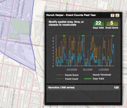
The “hunch work” is in the Early Warning component, which is what interested me the most.
I have a hunch about what alerts I want
Hunchlab’s Early Warning tool can send alerts to users when crime levels deviate from statistical norms, or when they exceed a defined threshold in a specific geographic neighborhood. It gives the user a well-designed dashboard for adjusting parameters to get the alerts just right. So that alert emails arrive often enough, but not too often. That is, the alert threshold is not too high and not too low. Or the statistical window is not to wide or too narrow.
Call it “Geospatial Alert Lab”? Probably not.
So I think I would call this part of Hunchlab a very interesting “Geospatial Alert Lab” with great potential in many fields. Then I’d try to wire it up to other live data feeds besides crime — like earthquakes, land and sea temperature readings, wind speed and direction readings, mortgage foreclosures, maritime vessel tracking. Maybe even road traffic.
But “Geospatial Alert Lab” probably wouldn’t sell. They say 2012 is the year we drop “geospatial” from the marketing literature and erase “GIS” from the user interface.
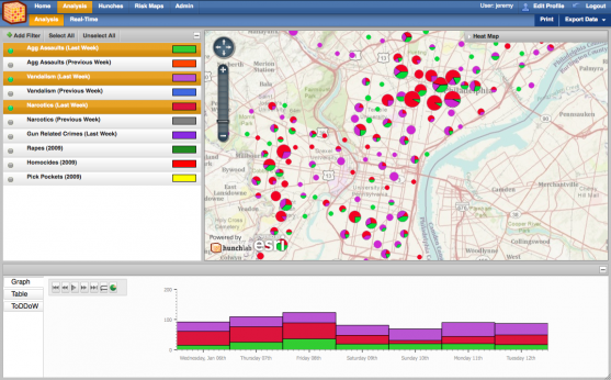 |
| Hunchlab: Crime Analysis |
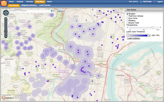 |
| Hunchlab: Near Repeat Pattern |
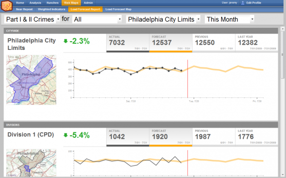 |
| Hunch: Load Forecasting |
