I am fascinated by the prehistoric landscape north west up the river Ure in North Yorkshire from the present day Boroughbridge fifteen miles to the village of Thornborough. As usual my interest grew through an introduction to a community group. In this case it was to the Boroughbridge and District Historical Society (BDHS) while I was working as a Community Archaeologist at York Archaeological Trust. I met some enthusiastic folk who were working on a project supported by the Heritage Lottery Fund. They needed help with their Dog Kennel Lane project undertaking geophysical survey looking for the remains of the Newby Hall estate dog kennel (see Figure 1 below).
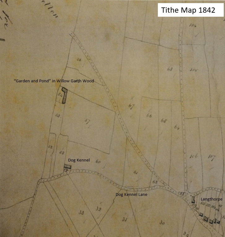
Figure 1: Tithe map from 1842 showing “Garden and Pond” and Dog Kennel.
We got distracted investigating a huge bank nearby. It had been known as General Wade’s Camp and recorded as a marching camp, from the winter of 1745, for the English army marching north to supress Scotland. We thought the bank was too big for that, it appeared huge! David Barley from the BDHS remembered playing with his friends on an embankment during the 1950s. The embankment has been levelled a little by ploughing, but it still stands proud in the landscape (see Figure 2 below). On the western slope of the embankment a wooded “romantic” garden has been created with its own ornamental pond. Although not part of the Newby Hall estate gardens the site is a secluded visiting spot easily visited by Georgian gentry taking a ride out on horseback or in a carriage.
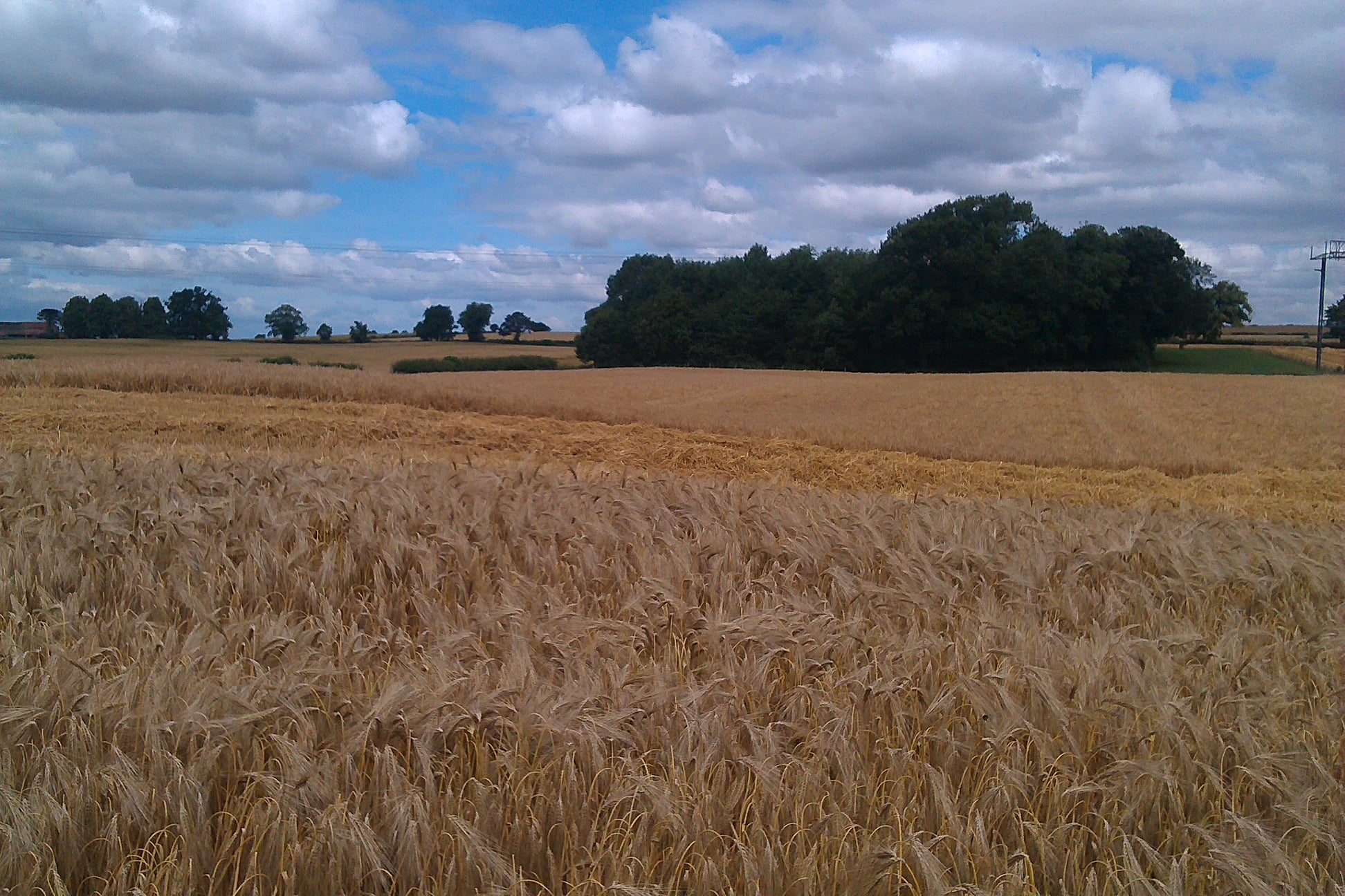
Figure 2: The embankment running north away from the camera under Willow Garth Wood. The slopes are not obvious to the eye but apparent when walked over.
On observing the LiDAR image of the embankment, it became much more apparent arcing away under the A1 and being imperceptible or indeed absent on the western edge of Boroughbridge (see Figure 3 below). I later asked Tony Hunt from Yorkshire Archaeological Aerial Mapping (YAAM) to look and his survey is overlaid on the LiDAR image in Figure 3. The survey suggested to me, and the BDHS group, a huge prehistoric site (or something strange and natural, got to keep that on the table). We checked the sites and monuments records at North Yorkshire County Council and found that the site had been located during the English Heritage National Mapping Programme (Monument number MNY19498). They had interpreted the site as a temporary camp created to shelter troops, part of General Wade’s army, camping on Langthorpe Field on their way to Scotland in the winter of 1745. We all felt that this embankment was too substantial for a temporary camp shelter, even if it was used for the whole winter. But in the end these are matters of opinion until some more substantial evidence is found.
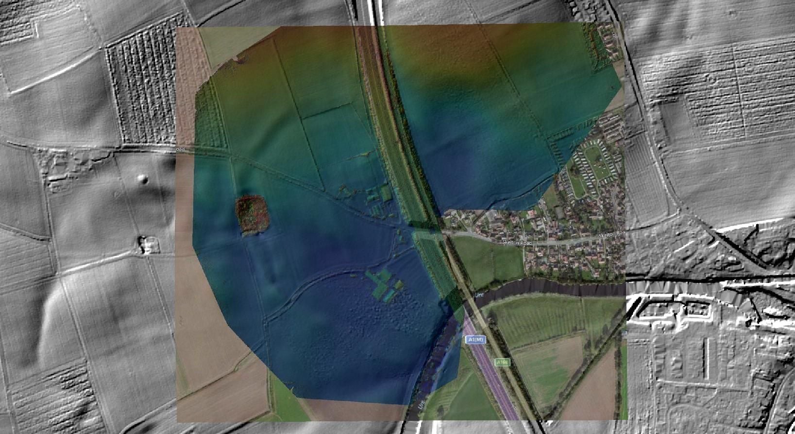
Figure 3: Drone survey by Tony Hunt over laid onto LIDAR image.
The geophysical survey was extended to see if we could find any activity inside the arc of the embankment. We did not have time to survey the whole area and what we did cover did not locate anything obvious (see Figure 4 below). Not even our dog kennel.
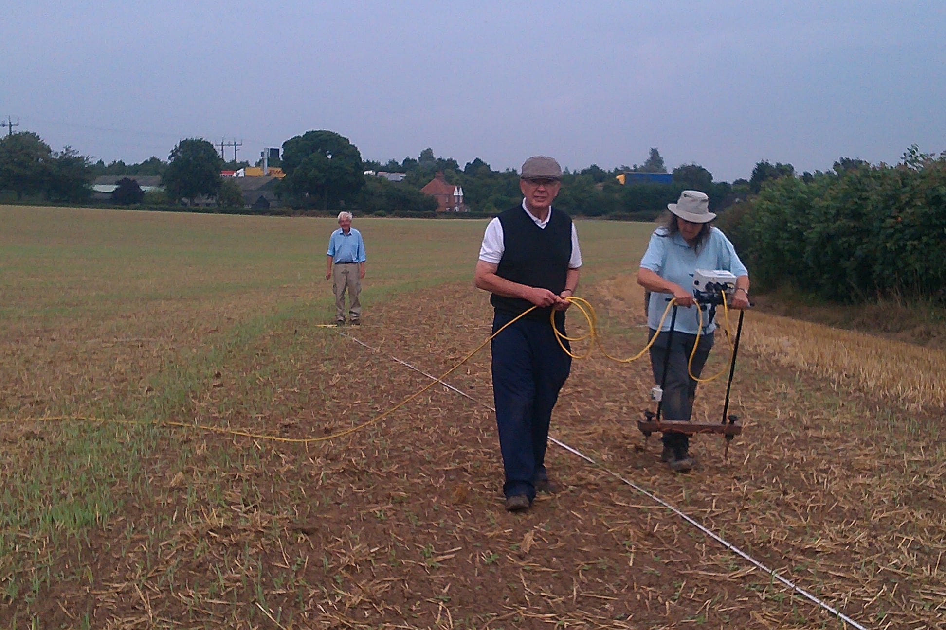
Figure 4: Members of BDHS undertaking earth resistance on the slope of the embankment. Looking for the Dog Kennel.
The Dog Kennel Lane project was made all the more exciting because it asked more questions of the landscape than we anticipated. You can read more about the Boroughbridge and District History Society here. http://www.boroughbridgehistory.co.uk/ Or buy the Dog Kennel Lane Book (not about the prehistory). The prehistoric aspect is interesting in the larger landscape view, the feature seems to enclose land to the north of the river Ure, a river that leads to other important sites, most notably Thornborough Henges.
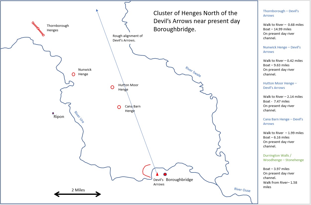
Just across the river from the site we were looking at stands an alignment of huge stone monoliths, the Devil’s Arrows. Probably dating to the late Neolithic or early Bronze Age (Historic England). A set of monumental prehistoric henges (probably also dating to the late Neolithic or Early Bronze Age) are roughly aligned north of the Devil’s Arrows. These have been discussed extensively by Jan Harding from Newcastle University and Blaise Vyner who both highlight the possibility that these henges were being used by peoples moving north – south through the landscape along the lowland rivers. Tony Hunt has not only looked at the possible prehistoric feature at Boroughbridge (Longthorpe Field). He has also flown the henges at Nunwick (all but ploughed out), Hutton Moor, Cana Barn and largest of all the triple henge at Thornborough, a site well known to archaeologists.
I find this group of monuments very exciting! Were they all in use at the same time? Were they used specifically by separate tribes or tribal groups or were they used by a more transient population coming to this landscape at particular times in the calendar. If people are using the river system to move about, as opposed to avoiding the wetlands for transport (as suggested by Vyner) maybe the monuments play different roles in society and they are mean to be approached from the rivers (see Figure 5 below). These monuments could link together along a riverside landscape just as impressive at Stonehenge or Orkney!
Mike Parker Pearson, is an archaeologist with a keen interest in Stonehenge and Woodhenge in Wiltshire. He recognised similarities in the layout of the stones at Stonehenge and the posts at Woodhenge. While he was working in Madagascar (with Ramilisonina), he saw ritual megaliths and posts that are still erected today. Some Madagascans associate stone with their deceased ancestors, and wood with living people. Perhaps it was the same more than 4,000 years ago at Stonehenge (see Figure 6 below).
Mike Pitts wrote about this in the Archaeology Magazine in 2008:
“The landscape, they argued, could be divided into two “domains,” that of the ancestors around Stonehenge in the west, and that of the living beside the River Avon in the east. Debris, including bones of butchered pigs, had been recovered from the timber monuments at Woodhenge and Durrington Walls but no evidence of feasting and few artefacts have been found at Stonehenge despite structural similarities between the sites. That, said Parker Pearson and Ramilisonina, was because the stone monument was inhabited only by the spirits of the ancestors.” (Pitts 2008).
It is possible that the journey from the ‘land of the living’ Woodhenge and Durrington Walls to ‘the land of the dead’ Stonehenge was taken in part by river. Heading on a boat down the river Avon and then disembarking to head up The Avenue to Stonehenge. The concept of making a journey by boat along a river to the place of the dead is of course a recurring ritual concept in later classical thought.
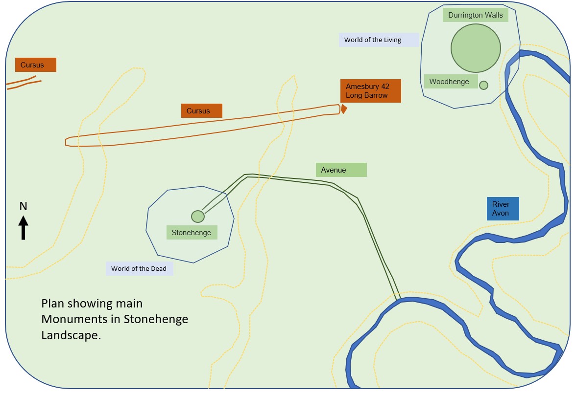
Figure 6: Stonehenge (land of the dead?) and Woodhenge / Durrington Walls (land of the living?).
Why not these same concepts along a 15 mile stretch of the River Ure in Yorkshire (see Figure 5 above)? Following a ritual to do with living and dead. From the huge Thornborough henge via Nunwick, Hutton Moor and Cana Barn to the equally huge embankment at Boroughbridge and the Devil’s Arrows nearby (See Figure 7 below). From the available evidence none of the northern henges are stone, but the Devil’s Arrows clearly are. In fact good dating would be a start for these henges, are they all in operation at the same time? It is also about a 5 mile journey along the river Avon in Wiltshire, but 15 in Yorkshire.
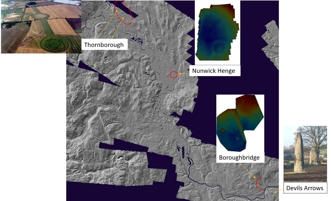
Figure 7: From Thornborough to Boroughbridge.
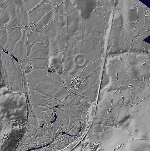
There is no evident avenue from the river Ure to Thornborough for example, but that may still to be found. A closer look at the LiDAR of Nunwick Henge however, might suggest the tail of an avenue heading towards the River Ure (see Figure 8 below).
The henges might be seen as domains of the living, built with earthen banks, ditches and wood, like Durrington Walls. Although there are barrows at Thornborough. The line of monoliths at the Devil’s Arrows might then be a domain of the dead. Historic England, in their description of the Devil’s Arrows, mention a wider complex of extensive and intensive prehistoric remains to the west of the Devil’s Arrows. The very spot that some two thousand years later the Roman’s chose to build a fort and not far from where they established Isurium Brigantium.
There are all kinds of other possibilities about how these monuments might go together, indeed they may not even be in use at the same time. It is certainly an interesting trip from Dog Kennels to speculating about our Prehistory!
There is plenty to read about:
Mike Pitts in the Archaeology Magazine (2009):
https://archive.archaeology.org/0801/etc/henge.html
Nicolas Thomas Reviews Jan Harding from Newcastle University report on Thornborough Henge:
http://www.prehistoricsociety.org/…/Thornborough_final…
The Abstract for an article on henges and water by Colin Richards back in 1996 (you have to pay for the whole article click here):
Henges and Water: Towards an Elemental Understanding of Monumentality and Landscape in Late Neolithic Britain.
This paper examines the adoption by archaeologists of perspectives of ‘land scape’ currently being explored in the social sciences. Despite an appreciation of the social construction of landscape and nature, it is suggested that generally archaeologists have failed to take account of the significance of the social identification of ‘natural’ constituents of the world. Virtually all societies identify particular ‘elements’ in the composition of the experienced world and cosmos. The importance of these elements is that they represent the basic substances from which everything is derived and to which every thing decays (including humanity). Therefore, elements maintain ontological status and provide a potent symbolic medium of expression. Here the late Neolithic henge monuments of Britain, the architecture of which has defied archaeological interpretation, is examined in terms of a representation of landscape and a strategic deployment of ‘elements’. In particular, the element of water is identified as being a major component in their architectural image and symbolic constitution. The henge monuments are shown to embody a physical representation of the local topography and to draw heavily on that topography to create a series of homologies of landscape. A crucial aspect of this observation is the suggestion that archaeologists have misconceived the visual appearance of henge monuments, particularly the probability that the enclosure ditches were receptacles for water. Furthermore, it is argued that the relationship between henges and rivers provides a metaphorical con junction between the natural flowing of water and human movement into the monuments. It is hoped that this study will focus attention on the importance of the social constitution of nature and landscape, and the influence this may have on the materiality of architectural representation.
And of course, Blaise Vyner on the North South movements of people along the Vale of York (you need to pay to read the whole article click here):
A Great North Route in Neolithic and Bronze Age Yorkshire: The Evidence of Landscape and Monuments.
‘Many are the Yorkshire chiefs and their families who must have journeyed down the Jurassic Way … on a pilgrimage to Stonehenge’ (Thomas 1955, 436). The Jurassic Way has long been dismissed as a prehistoric route (Taylor 1979), but it is suggested here that there is evidence in the Vale of York monuments for a long-distance route southwards and northwards through the vale which brought the Neolithic people of eastern Yorkshire, and perhaps beyond, to ritual complexes along the River Ure. It was here, as Bradley and Edmonds (2003) and Harding (2000) have shown, that communities gathered for rituals which included the exchange of axes and ideas.
