View, edit, and transfer different types of maps. Open vectorial, topographic, scanned, and satellite maps in ECW, BMP, JPG, TIF, TIFF, PNG, and other formats. Plan your trips and add tracks, routes and waypoints to your maps. Sort your tracks by activities, distance, slope, and other categories.
World Book Day special promotion: 35% discount from today to April 23th. Don't miss this opportunity!
CompeGPS Land is the software that will let you take the most of your outdoor trips. Its great variety of planning, navigation and analysis tools is the perfect basis for any professional or amateur (Trekking, Mountain bike, 4X4, Skiing, etc.). Get the best efficiency and lots of fun.
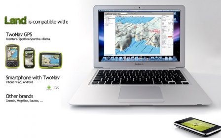
Visualize digital maps, download them by free from Internet or calibrate paper maps and manage all the necessary information for your trips over them. CompeGPS Land is optimizing for TwoNav devices, either dedicated GPS devices (Sportiva/Sportiva+, Aventura), or devices with TwoNav installed (iPhone, Android,...). You can also communicate with Magellan and Garmin, and almost all new GPS receivers for upload/download waypoints, routes and tracks
-----------------------------------------
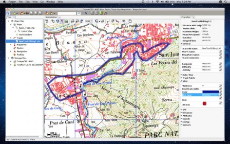
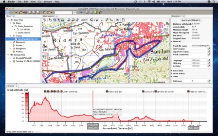
Create, edit your tracks, routes and waypoint
Load a map and start creating your itinerary by adding some waypoints. You can open/save data (waypoint, route and track) in other format like: *.trk, *.btrk, *.gpx, *.kmz, *.plt, *.log,...
-----------------------------------------
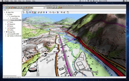
Start an incredible 3D experience
Download our free 3D maps from all around the World and work in the most realistic way. You won’t believe it!
-----------------------------------------
Synchronize your photos with your track
It will let you manage and locate your digital photos regarding to the position they were taken. It can read *.jpg digital photo and attach to each file the coordinates of the track point.
-----------------------------------------
Work with any types of maps
CompeGPS Land proposes you a wide compatibility with most used map formats (*.bmp, *.jpg, *.tiff...). You will also be able to view and edit several vectorial formats, topographic maps, satellite images and more. If this is not enough for you, you can create your own maps by scanning the paper maps that you may have or by mixing different maps format according to the zoom!
Get also a free access to On-line maps (like OpenStreetMaps) from many countries and the choice between the most complete catalogue of the market!
-----------------------------------------
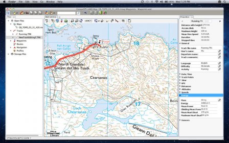
Play with a bunch of data
Get a full report of your activity through your recorded track: Distance, Max Height, Accumulated Ascension, Max slope, mean speed, Max heartbeat, energy burnt, and much more. You can also display these data on our advanced graph system.
Store your tracks into a logbook to keep them organized in the best way (by calendar, periods, Comparison of the most representative data...).
-----------------------------------------
Advanced features
Communication
• Direct communication with TwoNav devices
Maps
• Import every kind of format:*.bmp, *.jpg, *.tif, *.tiff, *.png, *.map, *.sid, *.geo, * .kap, *.jp2, *.mappoint, *.sigpac, *.dbx, *.e00, *.shp, *.dgn, *.mif, *.tab, *.drg, *.aprs, *.wgom, *.cwms, *.imp, *.rmap, *.mpv, *.mpvf, *.hmap.
• Advanced transparency system to combine the information of several maps
• Access to free online maps (OSM,...) and create offline sections in *.rmap format to be displayed in TwoNav devices (service subjected to copyright limitation from map providers)
• Over 100 map Datums supported
• Support for many Map projections and Grid systems.
• Print maps
Navigation/Tracks
• Create your own Roadbooks
• Show your position in real time on the map (live data)
• Track formats compatible: *.trk,*.btrk,*.igc,*.gpx,*.tcx,*.kmz,*.plt,*.cmp,*.log,*.nmea
Interface
• Last generation 3D Viewer to work in a more spectacular and realistic way.
• Dynamic multi-window system (docked or floating)
• Data tree for better organization and open or stored files management
• Tracks library to organize all your trips by date, distance, activities,...

Comments