Endalen
Endalen is a valley in Spitsbergen, Svalbard and has an elevation of 150 metres. Endalen is situated close to the suburb Nybyen and the locality Haugen.Notable Places in the Area
Lars Hiertafjellet
Peak

Photo: Bjoertvedt, CC BY-SA 3.0.
Lars Hiertafjellet is a peak situated 3½ km west of Endalen.
Localities in the Area
Nybyen
Suburb

Photo: Wikimedia, CC BY-SA 3.0.
78°12′N 15°35′E / 78.2°N 15.59°E Nybyen is a small settlement located on the southern outskirts of Longyearbyen, on the island of Spitsbergen, in the Svalbard archipelago of Norway. Nybyen is situated 4 km northwest of Endalen.
Longyearbyen
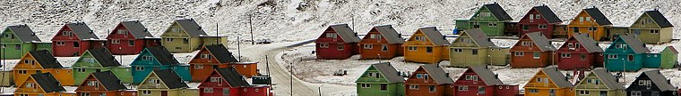
Photo: Uspn, CC BY-SA 3.0.
Longyearbyen, is the largest populated area, and capital of the Norwegian region of Svalbard.
Endalen
- Type: Valley with an elevation of 150 metres
- Category: landform
- Location: Spitsbergen, Svalbard, Norway, Nordic countries, Europe
- View on OpenStreetMap
Latitude
78.16754° or 78° 10' 3" northLongitude
15.66378° or 15° 39' 50" eastElevation
150 metres (492 feet)Open Location Code
CFCQ5M97+2GGeoNames ID
2731352Endalen Satellite Map
© OpenStreetMap, Mapbox and Maxar
Also Known As
- Norwegian: Endalen
Other Places Named Endalen
Localities in the Area
- HaugenLocality, 5 km north
- VindoddenLocality, 27 km northeast
- Kapp BelvedereLocality, 28 km northeast
- Barentsburg
- SveagruvaVillage, 38 km southeast
Landmarks in the Area
- TrollsteinenPeak
- LarsbreenGlacier, 2½ km west
- SarkofagenRidge, 3½ km northwest
- GruvefjelletMountain, 3½ km north
- LongyeardalenValley, 4 km north
Popular Destinations in Svalbard
Discover Longyearbyen, Bear Island, Barentsburg and Ny-Ålesund.
Escape to a Random Place
Discover other valleys in the world.
About Mapcarta. Thanks to Mapbox for providing amazing maps. Text is available under the CC BY-SA 4.0 license, excluding photos, directions and the map. Photo: Wikimedia, CC BY-SA 3.0.