By Lawrence R. Zamoras, PhD.
Updating of the Geohazard Map of the Municipality of Midsalip, Zamboanga del Sur was undertaken on May 13 to June 7, 2017. The program primarily aims to update geological hazards assessment and mapping at 1:50,000 scale completed by the agency in 2008. The team is composed of MGB-IX geologists; Lawrence Zamoras, PhD. and Reginald U. Skibba.
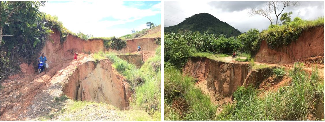
The Municipality of Midsalip is widely susceptible to rain-induced landslide particularly those mountainous areas covering the western, southern and northern portions of the municipality. These areas are susceptible to landslide prompted by torrential rains or during the monsoon season. Other forms of mass wasting have been noted along unprotected riverbanks, streams and creeks.
In this study the topography of Midsalip is subdivided into three different terrain groups namely, (1) Pinukis Volcanic environs, (2) Midsalip Valley, and (3) Northern hilly terrain. The Pinukis Volcanic area has a cluster of volcanic cones having steep peaks comprising the southern part of Midsalip Municipality covering barangays Cabaluran, Cumaron, Duelic, Dakayakan, Piwan, Guinabot, Sigapod, Balonai, Pisompongan, Matalang and Lumponid.. Its steeply sloping grounds have highly weathered materials forming thick soil layer over steeply sloping terrains ground materials. The steep slopes characterizing the terrains within the Pinukis volcanic area are naturally landslide prone. Its peak elevations ranging from 800 to 1500 meters create a locally more humid climate thus having more frequent rainfalls. Such conditions most likely generate more landslides since the materials composing the steep slopes contain high proportion of soil and highly weathered rocks. Its prevailing landslide susceptibility ratings range from HIGH to VERY HIGH. Some of its areas near drainage channels especially during heavy and/or prolonged rainfall. However, the flooding duration is short since the slope gradient is generally steep which causes quick water flow. A number of puroks have built-up zones along the valleys particularly those confluence of drainage or river channels raising the flood susceptibility ratings to MODERATE to HIGH.
The Midsalip Valley is located in the eastern portion of the municipality covering the barangays of Bacahan, Bibilop, Buloron, Poblacion A, Poblacion B, Lumponid, Guma, Dumalinao, Timbaboy, Canipay Sur and Canipay Norte. The valley is characterized by flat to rolling terrain which has an average elevation of 300 m above sea level. Due to the generally flat to gently rolling terrain, the area is least susceptible to landslides. The landslide-prone areas are mostly confined along riverbanks whereby river flow causes erosion along riverbanks especially those along the outer sides of meanders. The river system draining the valley includes Guma River, Bacahan River, Midsalip River, Guinabot River and Timbaboy River. These river channels are relatively deeply incised across the rolling terrain. During intense rainfalls, floodwaters are mostly confined along the channels. Populated zones and built-up areas are commonly situated along roadsides that are outside the reach of flooding. Most areas that are within the coverage of flooding are ricefield areas that are situated on low elevation areas.
The northern part of Midsalip is a hilly terrain with extensive ridges incised by deep river valleys. Unlike the southern part of Midsalip the north has no prominent volcanic cones that rise above the hills. This northern hilly terrain hosts the barangays of Palili, Ecuan, Golictop, Guitalos, Tuluan, Tolbong, Kahayagan, Licuroan, New Unidos, New Katipunan, Pawan and Pili. The landslide susceptibilities in these areas vary widely from LOW, MODERATE, HIGH to VERY HIGH. Areas with LOW landslide susceptibility normally occur on plateaus and valleys while those with HIGH landslide susceptibility are along the steep flanks of hills and ridges. Their flood susceptibilities likewise vary from LOW, MODERATE to HIGH but are only confined along narrow floodplains which are sparsely inhabited.
Since this 2017 landslide and flood geohazard assessment serves as an update of the 2008 Geohazard Mapping for Midsalip, a comparison of the ratings has been done. However, the 2008 Geohazard Map for Midsalip used a 1:50,000-scale which is a regional scale while the 2017 (current) Geohazard Map uses a 1:10,000-scale which is more detailed. These two mapping scales have different categories for flooding and for landslide. For instance, there are only three landslide categories in the 1:50,000 format namely LOW, MODERATE and HIGH, while there are four in the 1:10,000 format namely LOW, MODERATE, HIGH and VERY HIGH. For the 2008 Geohazard Map used only two categories (LOW and HIGH) for flooding while for the 2017 Geohazard Map three categories are used (LOW, MODERATE and HIGH). As a result, a number of puroks in the 2017 geohazard map have totally different landslide or flood susceptibility ratings.
Detailed Landslide and Flood Susceptibility Map of Midsalip, Zamboanga del Sur

(This excerpt was taken from the MGB-IX Technical Report entitled “Updating of the 1:10,000 Scale Geohazard Map of Midsalip, Zamboanga Del Sur”.)
