Tag Archives: crop marks

Castle Hill “Henge” at Muir of Ord – A Controversial Structure

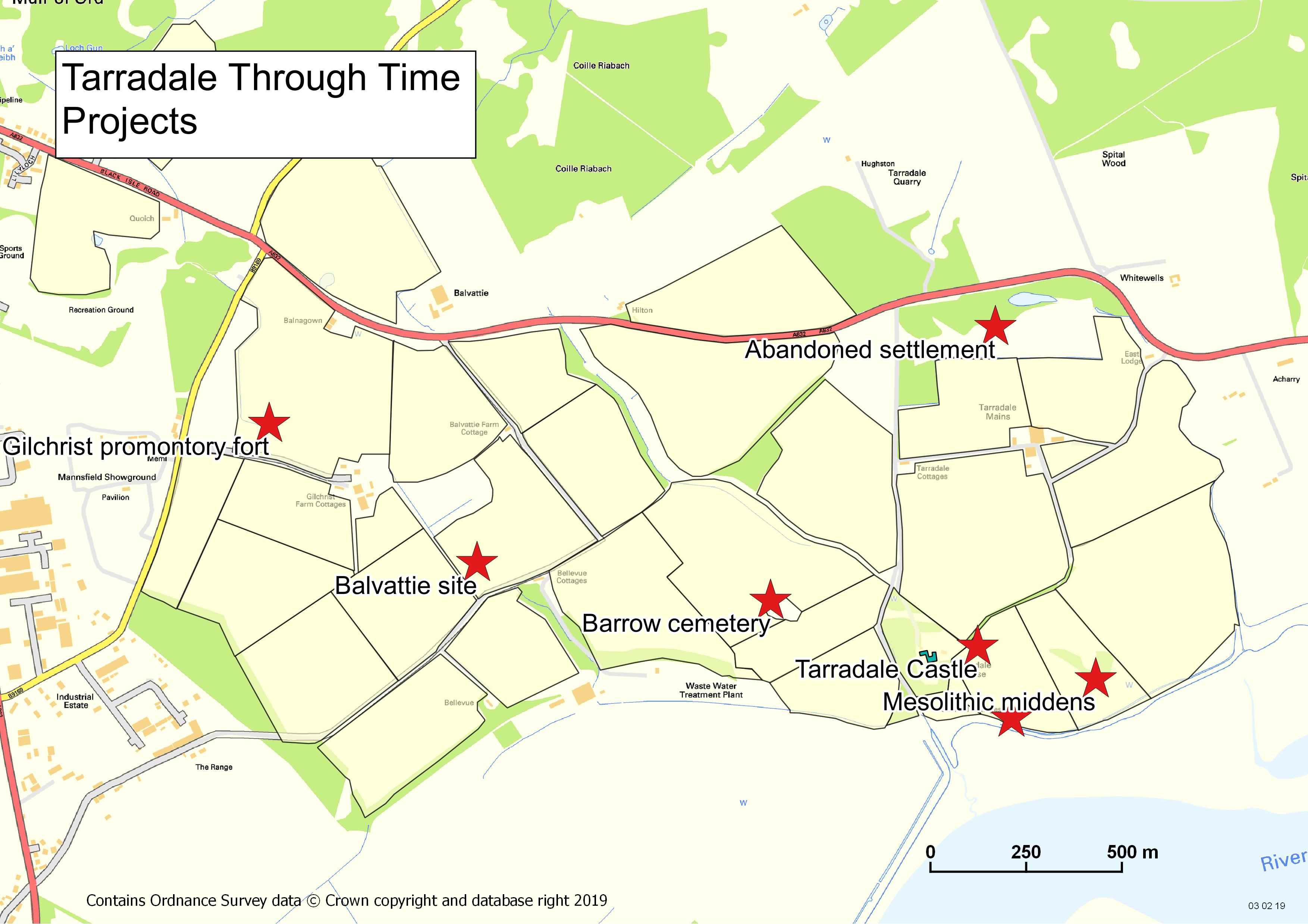
by Roland Spencer-Jones

Muir of Ord Golf Club may be unique in having a green on top of a scheduled ancient monument. Castle Hill, the 13th green, is an artificially modified mound, standing at the north end of a ridge, proud of the surrounding flat ground. Its perimeter is delimited by a raised bank inside of which is a circular ditch, with two gaps at NW and SE. This bank and ditch enclose an oval flat area approximately 28 m by 21 m. The ridge probably represents an alluvial glacial moraine before the end of it was subsequently modified.

There has been considerable discussion and debate in the archaeological literature over the last 350 years as to the nature of this feature, when it was created, and for what purpose. However, whatever its nature, it is special, recognised as such by being included in the list of ancient monuments in Section 12 of the Ancient Monuments Consolidation and Amendments Act 1913. This important act of scheduling was reported to the Right Honourable Lord Lovat in a registered letter dated 11th April 1957. In the scheduling documentation[1] it was called Castle Hill Fort or Henge. Scheduling is the process that “identifies, designates and provides statutory protection for monuments and archaeological sites of national importance”, with damage to a scheduled site potentially incurring criminal charges. This became relevant in the early 1980’s, see later.

Castle Hill in 1972 © Historic Environment Scotland: John Dewar Collection

Early Descriptions of Castle Hill

The first historical mention of this prominent feature was towards the end of the 17th century in a massive volume of archaeological recording, the Monumenta Britannica, written by probably Britain’s first archaeologist, John Aubrey (Aubrey, 1665-93). In it, Aubrey records part of a letter he received in 1692 from a Dr James Garden, Professor of Theology in the King’s College at Aberdeen. Aubrey had written to many local dignitaries and antiquarians throughout Northern Britain asking for information about stone monuments. He was delighted to receive this full response from Dr Garden in which the latter refers to a sacred grove thus: “I … have gotten information of two groves yet standing which are reputed sacred. One of them (which stands near to a place called Taradale in the parish of Killernen and shire of Nairn) is enclosed with a trench or dry ditch having two entries to it where the ditch is filled up or rather the ground has never been broken: all that live near it hold it as sacred, and will not cut so much as a rod out of it: my informer adds that, hard by, there is a cornfield where he conjectures there has been one of the Monuments, because in it there are several big stones such as those Monu­ments use to consist of, fallen down and out of order.” Taradale, now Tarradale, is the name given to the settlement that later came to be called Muir of Ord once the railway arrived in 1862. Garden’s description of the “sacred grove” fits nicely with the structure now called Castle Hill. Also note the description of standing stones in the vicinity, which we will come on to later.

Continue reading

Droning on about Tarradale

by Andy Hickie

Drone image of Tarradale Through Time barrow cemetery dig, as featured in “Current Archaeology” November 2019.

Back in 2017, I caved in to the demands of consumerism, and purchased a new quadcopter, a Phantom 3 Advanced, which is equipped with a camera and GPS unit. I flew multiple flights around Avoch but, after a while, the novelty of seeing one’s house from the air at different angles and altitudes begins to wear thin, and I began to wonder what I could actually do with a drone. Having always had an interest in archaeology and, spurred on by seeing some of the images Alan Thompson of NOSAS had created, I decided to carry out a few experiments of my own.

My first flights took in locations such as the distillery and settlement at Mulchaich, and the features of Kinbeachie castle – sites which had already been mapped by Alan by drone, the results of which I could use as a ‘benchmark’ against which I could compare those of my own.

At the same time, I began experimenting with various flight planning apps which allow for off-line autonomous flight planning, as well as online platforms for image processing. I found that “DroneDeploy” and “Mapsmadeasy” combined provided a fairly user-friendly pipeline, whereby image capture and photogrammetry can produce georeferenced photomosaics and digital surface models (DSMs). These can then be imported into software such as QGIS for further processing.

Having found the software which satisfied my needs, I then turned my attention to potential sites which I could map – and decided on the cropmarks of the Barrow Cemetery at Tarradale. At this point, my intent was purely to satisfy my own curiosity – just to see what I could see, and how it would compare with the archaeology found at the forthcoming 2019 dig.

And so, on 10 June 2018, accompanied by my daughter Emma to act as co-pilot and “spotter”, I visisted Tarradale to map the area with the drone. I can still recall the excitement I felt as the images began to appear on the monitor of the remote controller, which showed the cropmarks were developing. However, my satisfaction was tempered somewhat when I got home and began to process the photographs. Although the cropmarks were indeed evolving, the crop was insufficiently ripe, and many of the details remained hidden (see image below).

Continue reading

Tarradale Through Time: 2018 Excavations

by Eric Grant

In September 2018 two sites were investigated by TARRADALE THROUGH TIME near Muir of Ord. These were a fortified enclosure just west of Gilchrist church and a rather enigmatic and possibly ritual site south of Gilchrist church, but located on Balvattie Farm.

Gilchrist Promontory Fort

The Gilchrist fort is a rather unusual monument  and walking past it gives no clue to its existence, size or age. Canmore describes it as a promontory fort based on their interpretation of crop marks as the arcs of three concentric ditches “Apparently designed to cut off approach to a tongue of low-lying and comparatively level ground running NW into marshland, they are in effect part of the defensive system of a promontory fort measuring about 85 m by 30 m”.

In addition to the black-and-white photographs on the Canmore database, the late Jim bone, who was an enthusiastic archaeologist and also a pilot, took some good colour photographs of the site. Jim’s aerial photograph shows three dark green curved features representing the fort’s ditches on the east side of the promontory. The ditches are now under cultivation and have been filled in and ploughed flat so there is nothing to see above ground; it is only the aerial photographs that have encouraged archaeologists to see this as a fortified promontory. It is unusual to find a promontory fort inland unless it is in a situation like this where it is surrounded by water or marshland. Most hill and promontory forts in Scotland appear to have been constructed during the late Bronze Age and Iron Age and the latest ones were built or reoccupied in Pictish times.

Aerial photograph of Gilchrist showing ditches as dark green curves (JS Bone Collection)

Our research agenda sought to identify and characterise the ditches, and to ascertain when the fort was constructed, how long it was occupied and what activities may have taken place there. Three large trenches were initially opened, one running at right angles across the defensive ditches, a second running from the long side of the fort down into the bog and a third on the highest part of the interior of the fort. We were very quickly able to establish that the three ditches seen on aerial photographs did exist, with a hint of a fourth ditch closer into the fort. The outermost ditch was reasonably shallow but the second ditch was a massive construction 5-6 m wide at the top and sloping steeply to about 1.5 m below the plough soil though we consider that the upper part of the ditches have been lost due to ploughing and the intervening banks of excavated material flattened. The third innermost ditch was not quite so deep, but right on the edge of the actual fort area we found what may be an inner ditch that might have continued round the fort perimeter as a wall and perhaps with a timber fence palisade on top or just in front.

Plan of Gilchrist excavations showing crop marks and trenches (HAS)

Continue reading

Jim Bone: Aerial Photography of Archaeological Sites

Jim was a founder member of NOSAS, which celebrated its 20th anniversary in 2018. He was known in the Highlands for providing important aerial photos of numerous archaeological sites over many years. Sadly, Jim died on June 16th, after a long and wearisome illness. His extensive collection of aerial photographs has been gifted to NOSAS and will form the JS Bone Collection, in his memory. This is the story he wrote of himself, in the months before he died. (Introduction revised Sep 2018).

Aerial photograph of Mulchaich, Ross-shire. The settlement , distillery and chambered cairn at Mulchaich were the subject of NOSAS projects between 2009 and 2013. See the blog post.

It appears to me that people can be divided into two categories – those who love flying, and those who do not.  Brought up in close proximity to Prestwick Airport, I recall watching aircraft there, and determined that I would one day find out more about aviation.  Inspired by a selection of Biggles books, I joined the local ATC (Air Training Corps) squadron, enabling me to sample flight for the first time in 1950 in an elderly Anson.  Military aircraft have a distinctive odour of aluminium and oil, complemented in this case by an off-putting whiff of vomit, but I enjoyed this first ‘air experience’ flight along the Ayrshire coast.  For the next flight, I borrowed a folding camera, and tried a few shots through the rather scratched Perspex window.  Surprisingly, the results came out quite clearly, and another interest was born.

Going to University in Glasgow, I lost no time in finding the HQ of the University Air Squadron (GUAS), and was fortunate enough to be accepted as a Cadet Pilot in the RAFVR.  This offered a high standard of flying training, during 1953-7, provided by experienced RAF instructors at Scone Airfield outside Perth.  Our Chipmunk aircraft was state of the art at that time, but cameras were not encouraged on training sorties.  At the end of my four years, I asked if I could take a camera with me on a dual flight with my instructor, having noticed some archaeological sites which I wanted to photograph.  By opening the hood, I was able to take quite a good shot of a hill fort to the south of Perth, which presaged further attempts in later years.  The Squadron experience qualified me for a Preliminary Flying Badge – a sort of junior wings – and allowed me to apply for a Private Pilot’s Licence, costing a very reasonable ten shillings, when I left the unit. Continue reading

The Picts at Garbeg and Whitebridge

by James McComas (NOSAS)

The Pictish people of the mid to late first millenium AD once inhabited what is now northern and eastern Scotland. They left very little written record and the evidence of buildings so far identified are sparse. Perhaps their most obvious remains in the landscape are the enigmatic symbol stones and the imprints of their burial sites.

Although modern Angus and Perthshire have traditionally been seen as the Pictish heartland, in recent years new research is reveavaluating the importance of the northern picts, north of the Mounth. Two highland burial sites which feature impressive upstanding remains are to be found on opposite sides of Loch Ness; at Garbeg near Drumnadrochit, and at Whitebridge in Stratherrick. Pictish funerary practices appear to have been diverse (see our earlier blog post), however barrow* cemeteries have been identified as one recognisable form. Round and square type ditched barrows appear alongside each other at both Garbeg and Whitebridge – a feature thought to be unique to the Pictish cemetery.

Side by side comparison of a plan of part of the Garbeg cemetery and a quadcopter aerial photo by Alan Thompson. (The brown patches on the photo are the result of recent gorse clearance, and dark green areas are piles of cut vegetation.) The barrows excavated by Wedderburn and Grime on this plan are nos 1,2,3 and 8.

Side by side comparison of a plan of part of the Garbeg cemetery and a quadcopter aerial photo by Alan Thompson. (The brown patches on the photo are the result of recent gorse clearance, and dark green areas are piles of cut vegetation.) The barrows excavated by Wedderburn and Grime on this plan are nos 1,2,3 and 8.

Garbeg and Whitebridge were visited by NOSAS field trips in 2014/ 2015 and Garbeg has also been the subject of gorse clearance, quadcopter photography (blog post section 4) and QGIS survey by the group. Subsequently in 2015 many NOSAS members were involved with survey and excavation by the University of Aberdeen’s Northern Picts Project on possibly contemporaneous building remains at Garbeg.

The cemetery at Garbeg (Canmore ID 12281, HER MHG3361) consists of 23 square and round barrows with surrounding ditches. The barrows are thought to cover single long cist burials. They are situated on a natural plateau at an altitude of some 300m on open moorland used for rough grazing.  The immediately surrounding landscape is one rich in archaeological remains, including prehistoric field systems, groups of hut circles and a series of burnt mounds which are largely thought to predate the Pictish period.

Members of NOSAS at a field visit to Garbeg, November 2014

Members of NOSAS at a field visit to Garbeg, November 2014

Continue reading