Hiking : Seehof Weiher (West) - Erlenbach bei Dahn
Deutschland Rheinland-Pfalz Südwestpfalz Erlenbach bei Dahn
&fill=rgba(0,0,0,0))
Durée
Distance
Dénivelé
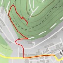
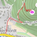
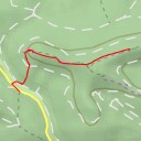
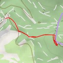
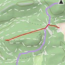
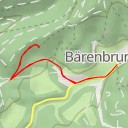
This hiking route will take you to the Seehof Weiher (West) in Erlenbach bei Dahn. The area is known for its beautiful natural surroundings and serene atmosphere, making it a perfect destination for a relaxing hike.
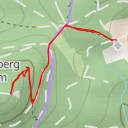
As you start your journey, you will come across several points of interest along the way. Just at the beginning of the trail, you will find a water source, perfect for filling up your water bottle before starting the hike. As you continue on, you will pass by the Kiosk am Seehof, where you can grab a quick snack or drink to recharge your energy.
Further along the route, you will encounter a parking area where you can leave your vehicle before starting the hike. Additionally, there are several benches and viewpoints scattered throughout the trail, providing perfect spots to take a break and enjoy the scenic views.
At around 893 kilometers, this out-and-back route has a relatively low elevation gain of 33 meters, making it suitable for hikers of all levels. However, it is always recommended to bring plenty of water, wear appropriate footwear, and check the weather forecast before embarking on any hike.
Overall, this hike to Seehof Weiher (West) offers a wonderful opportunity to connect with nature and enjoy a peaceful day outdoors. Don't forget your camera to capture the beautiful surroundings along the way!