
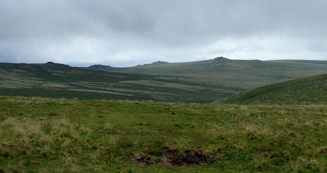
Looking north along the row.
A double stone row measuring 174.2m long, including at least 41 mainly small with some medium-sized stones situated on an east facing slope adjacent to the Lych Way. The row is orientated north to south and has noteworthy landscape and sea view reveals and links.
Location
| England Devon Dartmoor SX 58591 79076 Lat 50.59416921 Long -3.99930697 |
Map showing the location of Conies Down stone row.
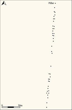
Simplified plan of Conies Down stone alignment (Source: Butler,J., 1991,).
Characteristics
| Type: Double | Length: 172.4m |
| No. of stones: 41 | Size of stones: Small and medium |
| Orientation: 10° | Altitude: 507m |
| Upper end: Pillar | Lower end: – |
| Straight (Yes or No) : No | Sea View: Yes |
| Context: Cairn? | |
| Notes: | |
Other Information
| Public Access: Yes |
| Land Status: National Park and Merrivale MOD Firing Range. Access only when firing not taking place. |
| Scheduled Ancient Monument: Yes |
Identification
Category: Plausible. No doubts have been expressed regarding the prehistoric interpretation of this row.
Typology
This stone row is of Type D10. Information on this form of stone row and other rows of this type is available here.
Photographs

Looking south along the row from the top (Scale 1m).

The row passing a granite outcrop. View from north (Scale 1m).
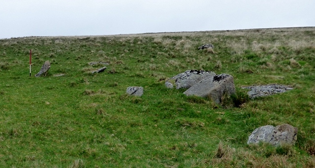
The row passing a granite outcrop. View from south (Scale 1m).

The southern end of the row. View from the south (Scale 1m).
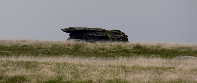
Very few of the stones remain standing. View from the north.
Landscape Reveals
A series of landmark reveals and other visual links to the surrounding landscape have been identified at Conies Down. These centre around a group of tors to the south west, but North Hessary Tor to the south and Conies Down Tor feature in what are a particularly interesting series of visual treats. The row itself is not remarkable but the way in which it seemingly relates to the surrounding landscape is.

Simplified plan of the Conies Down stone row showing the position of the points referred to below.
The South Western Tors
When standing at the top of the row five separate tors are visible protruding from the visual barrier provided by the rising ground to the south west of the row. As you walk south (down) along the row these slowly disappear one after the other, until the final one (Great Mis Tor) vanishes as you reach the very end of the row. The top of the row appears to have been positioned to ensure that the view of Little Mis Tor is at the intersection of the foreground and the background. A very precise visual link which would on the face of it provide an explanation for the choice of northern row terminal point. This compelling evidence for a link between the row and the landscape in which it was erected provides further support to the idea that the rows were positioned carefully to ensure that particular visual links could be referenced from the row and reminds us that the rows were clearly not built randomly with no consideration for the surrounding landscape. The visual links between landscape and the rows indicates that whatever their precise purpose they were erected to “signpost” some sort of interaction with particular places. It may be significant that the Conies Down row is situated adjacent to the historic Lych Way which may have been established in prehistoric times. It is probable that all the rows in prehistoric times were adjacent to well-used trackways and were possibly connected in some way with travel. Perhaps as well as developing a “ritual” purpose they were originally used as some sort of travel aid in a time before a well-developed track network was established. Once the track network had developed the rows may have no longer been needed and were abandoned then forgotten. Certainly, the skilful use of landmarks to permit travel in an age before the track network would have been crucial and the setting of many rows does seem to reflect this.
1 View from the top of the row
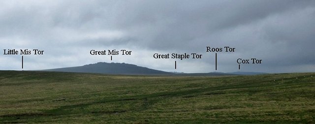
The five tors SW of Conies Down stone row are dramatically framed by the nearby rising ground.

Of particular interest is Little Mis Tor which stands on the skyline at the intersection of the foreground and background. When standing at the top of the row this feels deliberate.

Viewed from the top of the row Little Mis Tor seems to sit on top of the near hillside. This sort of optical trick is commonplace at stone rows and suggests a strong visual relationship between the rows and the landscape (© Gordon Fisher).
2 SX58589 79071
At this point 6 metres from the top of row Little Mis Tor disappears from view. It may be significant that Conies Down Tor at SX 58925 79100 which is visible from most of the row also disappears at this point.
4 SX58585 79041
As you walk southward along the row the SW Tors slowly sink below the near hillside.
5 From SX58584 79033

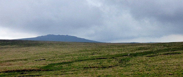
By this point along the row Great Mis Tor has shrunk but the remaining three tors protrude only slightly above the skyline.
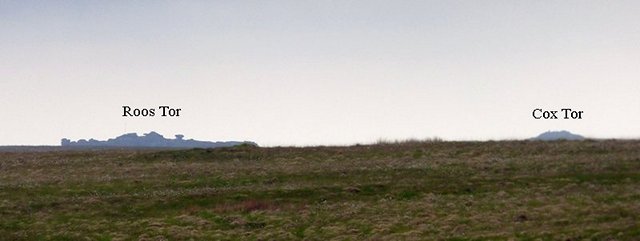
An optical illusion – Roos Tor and Cox Tor appear to be sitting on the nearby skyline. A visual treat that may have been of interest to the row builders.
6 SX58585 79032

Cox Tor has disappeared and only the very summit of Great Staple Tor is now visible (© Gordon Fisher).
7 SX58581 79023
A few steps later – Great Staple has also vanished.
8 SX58581 79013

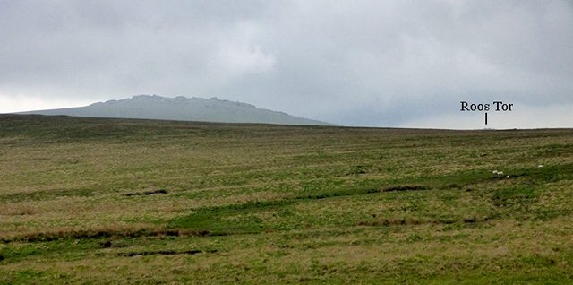
Only the tip of Roos Tor is now visible and Great Mis Tor is being swallowed up.
9 SX58563 78927

Final view of Great Mis Tor which vanishes from sight at the end of the row. The row seems to have been positioned to ensure that Great Mis Tor is at the limit of visibility at the bottom and Little Mis Tor at the top. The chances of this being a coincidence must surely be negligible and when you take into account similar visual links at other rows the evidence for a direct link between rows and the landscapes in which they were erected is powerful at least and compelling at best.
North Hessary Tor
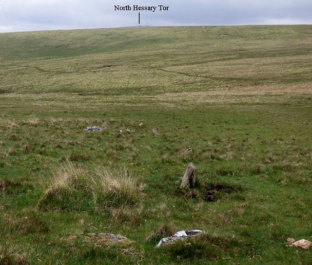
The Conies Down stone row is aligned directly on North Hessary Tor. Viewed from the top of the row the tor appears to sit neatly on top of the near hill slope. As you walk south along the row North Hessary Tor sinks below the horizon before finally disappearing at numbered point 3 in the plan above (SX58588 79060). Examples of rows that are directly aligned on a prominent landscape feature are rare. It seems that it is something that they sought to do but the other setting out considerations meant that it was not always possible.
The Eastern Tors
Compared to the south western tors this group of impressive tors do not appear to have been incorporated into the layout of the row. Viewed from the top and the bottom of the row the view towards these tors does not vary very much.
 View from the top of the row looking east towards a group of tors.
View from the bottom of the row looking east towards a group of tors. Very little has changed.
Conies Down Tor
Conies Down Tor at SX 58925 79100 may have been of significance to the row builders as it appears to have been incorporated into the layout. From the bottom of the row it dominates the north eastern skyline, but then as you walk up the row it slowly sinks behind the near hillslope before finally disappearing at the same spot [2 on plan above] where Little Mis Tor suddenly appears. This feels deliberate although of course it is not possible to prove.
Conies Down Tor viewed form the southern end (bottom) of the row.

Conies Down Tor just before it disappears from view.
Access Information
This stone row stands within the Merrivale military live firing range and it is important that you check that there is no firing and that the range is open for visitors before you set off. It can be reached either from the west or south. If approaching from the west, car parking is available at SX 52178 77879. From the car park follow the track leading eastward. This is a bit of slog but has the advantage of passing the stone row at Langstone Moor. Alternatively, access from the south is much easier although there is no path. Car parking is available at SX 59145 76462 and from here you should head due north across Black Dunghill before crossing Conies Down Water.
Acknowledgements
Gordon Fisher and Janet Daynes provided considerable help with the fieldwork.
Online Resources
Megalithic Portal Modern Antiquarian PastScape Historic Environment Record
Prehistoric Monuments of Dartmoor Prehistoric Dartmoor Walks
Other References
Burl, A., 1993, From Carnac to Callanish – The prehistoric rows and avenues of Britain, Ireland and Brittany, Yale University Press, New York and London, pg. 215.
Butler, J., 1991, Dartmoor Atlas of Antiquities – Vol. 2 – The North, Devon Books Exeter, pgs.76-7.
Timeline
VISITED:- 29th May 2017
FIRST PUBLISHED:- 16th January 2016
LAST UPDATED:- 31st January 2018
