
Southern length of the alignment. View from north. Click on image for higher resolution version.
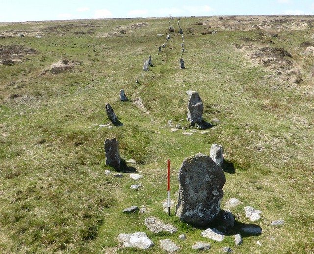
A splendid double stone row measuring 143.5m long, including at least 99 mainly medium-sized stones together with some small and large-sized stones situated on a north facing slope with extensive views over North Devon. The row is orientated NNE to SSW and was restored in the 1890’s. There is a cairn at the SSW end and a blocking stone at the lower NNE end. A later enclosure boundary cuts across the row and a prehistoric settlement built nearby was presumably constructed at the same time.
Location
| England Devon Dartmoor SX 67260 82437 Lat 50.626469 Long -3.8780323 |
Map showing the location of Hurston Ridge stone row.

Simplified plan of the Hurston Ridge stone alignment. (Source: Butler, 1991).

Map showing the position of Hurston Ridge, other stone rows and sites.
Characteristics
| Type: Double | Length: 143.3m |
| No. of stones: 99 | Size of stones: Small, medium and large |
| Orientation: 25° | Altitude: 436m |
| Upper end: Cairn | Lower end: Blocking stone |
| Straight (Yes or No) : No | Sea View: No |
| Context: Prehistoric settlement | |
|
Notes: Later prehistoric enclosure wall built across the alignment indicates that the row is earlier than the Middle Bronze Age. |
|
Other Information
| Public Access: Yes |
| Land Status: National Park |
| Scheduled Ancient Monument: Yes |
Identification
Category: Plausible. No doubts have been expressed regarding the prehistoric interpretation of this row.
Typology
This stone row is of Type D12. Information on this form of stone row and other rows of this type is available here.
Photographs

Looking northward along the row (Scale 1m).

View from the south west. The Hurston Ridge row has extensive views towards the north (Scale 1m).

Looking north along the row. The rows are not parallel and the distance between them varies along their length. The row is clearly not aligned on any particular feature.
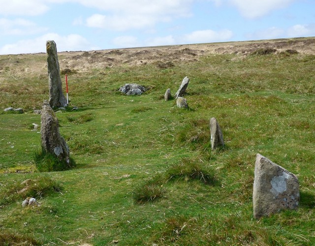
The southern end of the row. View from the north (Scale 1m).

This row is among the visually attractive of the Dartmoor rows. Similarities with the double rows at Merrivale are obvious. View from the south west.

View from the south west. The size of the stones in common with many rows vary considerably.

The double row leading up the hill. The tallest stone is visible on the skyline. View from north east.

Blocking stone at the lower end of the row. The row deviates sharply at this point. View from north.

Blocking stone and row beyond. The row splays considerably in the approach to the blocking stone. The tall stone at the southern end of the row appears on the skyline when viewed from the bottom. Even within individual rows limit of visibility considerations may have been important and further emphasise the crucial role this may have played. View from north.

The row is far from straight. Its sinuous form is reminiscent of the character of a footpath. This suggests that the row at Hurston Ridge may have been built to incorporate an existing sacred or “special” way. View from north.
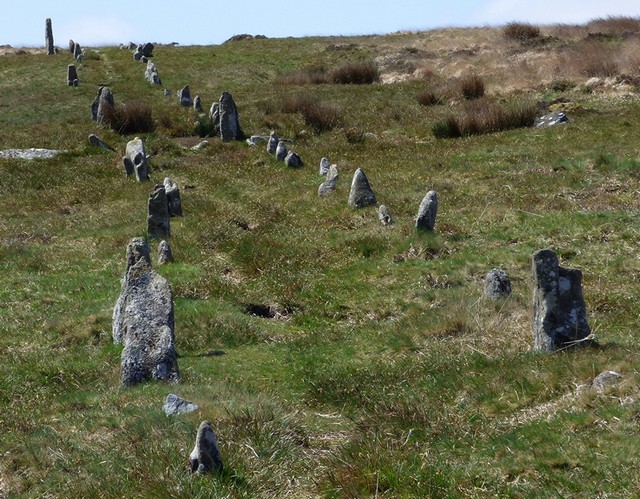
The splay in the row is obvious and certainly indicates that the row builders were not interested in precision. The width of the space between the stones was clearly flexible. View from the north.

Views to the north from the row are far reaching, whilst those to the south are none existent.

View from the south west with North Devon beyond.
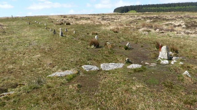
A prehistoric (probably Middle Bronze Age) wall indicated by the large granite slabs was built across the row. The stones forming the row were not utilised by the wall builders, indicating a level of respect or perhaps superstition for the earlier monument. This is a very human response. The presence of the row was not enough to stop them carrying out their plans, but they ensured that damage to the stone row was kept to a minimum. Rather like the modern approach to heritage and development.

The row and boundary wall. View from above and north (Scale 1m).

The building of the wall indicates that the row was no longer needed by the people who lived on this part of Dartmoor. It is evidence like this that provides the strongest evidence that the use of stone rows on Dartmoor at least had ceased by the Middle Bronze Age.

Blocking stone at the northern end of the row. View from the south.
Blocking stone and the row beyond. The splay is clearly visible. View from above and north (Scale 1m).

The northern end of the row.
Landmark Reveals

Viewshed (red) from the bottom of the Hurston Ridge stone alignment. There are extensive views towards the north but none towards the south. The viewshed from the top of the row is unsurprisingly very similar and is not repeated here at this scale. However, at the local level there are some notable differences which are worth remarking upon (Source: Heywhatsthat.com).

Simplified map highlighting those areas (red) which are visible from the upper end of the row, but are not visible from the bottom (blue). Source: Heywhatsthat.com
Compared with many rows the differences between the viewsheds is limited. However it is worth pointing out that the Challacombe Down triple stone row and Broad Barrow are visible only from the top of the row and therefore appear as one walks uphill along the row. These reveals may have been important to the row builders and enhanced the significance of a place that also provided a large number of limit of visibility views to a number of cairns including Quintin’s Man, Thirlstone, Hangingstone Hill, Single Barrow, Two Barrows, Mardon Down and Cosdon Beacon. The major ceremonial complexes at Fernworthy and Shoveldown would have also been in sight. The position of the Hurston Ridge stone alignment therefore provides a large number of significant visual links to other important ceremonial places in the landscape as well as permitting specific reveals to the Challacombe Down stone alignment and Broad Barrow on Hamel Down. The visual inter-relationships being exposed by this work points to a society very interested in the links between places and in turn implies that this was important to them.
Access Information
Car parking is available at SX 67576 81091 (50.614456 -3.8731007). From here carefully cross the road and head north across open moorland. The row is about 1,300m from the car park. A map or reliable GPS device is highly recomended. Well worth the walk.
Online Resources
Megalithic Portal Modern Antiquarian PastScape Historic Environment Record
Prehistoric Monuments of Dartmoor Prehistoric Dartmoor Walks
Other References
Burl, A., 1993, From Carnac to Callanish – The prehistoric rows and avenues of Britain, Ireland and Brittany, Yale University Press, New York and London, pg. 215.
Butler, J., 1991, Dartmoor Atlas of Antiquities – Vol. 2 – The North, Devon Books Exeter, pgs.30-31.
Time Line
VISITED:- 16th May 2015
FIRST PUBLISHED:- 24th January 2016
LAST UPDATED:- 22nd November 2020
