‘Monuments orchestrate human experience. Their size is so important because it is one of the ways in which this is achieved…this particular property of monuments, what WH Auden called ‘the language of size’, also means that particular information can only be obtained in a prescribed sequence’ (Richard Bradley Altering the Earth (1993), 47).
Yesterday all the past. The language of size
Spreading to China along the trade-routes; the diffusion
Of the counting-frame and the cromlech;
Yesterday the shadow-reckoning in the sunny climates.
WH Auden, ‘Spain 1937’
I used to walk along cursus monuments and call it work. This was my PhD research, an investigation into the Neolithic past. In fact, on reflection what I was doing was encountering contemporary rural landscapes in a subversive manner, following ancient routeways that have been lost amidst the organisation of the land today and which do not appear on any maps. I thought at the time that I was revealing insights into lost Neolithic lifeways and getting inside the minds of shaman, novices and ritual travellers. What I was in fact doing was exploring alternative ways to move around the landscape, following ancient routes, cutting across the geometry of railway lines, roads, fences and field boundaries, ignoring the straight lines of the twentieth century and instead following, slavishly, straight lines that were dug into the land over 5000 years ago.
I was creating my own cartographies, a mad man walking across empty fields taking notes and photos.
There can be no middle ground, no compromise, because there is nothing in the landscape today that respects Neolithic cursus monuments. The act of walking along a cursus therefore was one that showed no respect to the way we construct our landscapes today, a provocation, but when I was walking along cursus monuments and calling it work I did not see it that way.

Recently I walked along a cursus again, the first time I had undertaken one of these selfish walks since the 1990s, although I have visited a few cursus sites in between. ‘Cursus monument’ is a category of enclosure that dates to the first millennium of the British Neolithic (c3800-3300BC). These are rectangular enclosures, defined initially by lines of timber posts, and subsequently earthworks, with internal ditches and external banks. Like many archaeological categories, the label cursus hides a good deal of variation, with monuments ranging in length from 60m to 10km, and in width from 20m to 180m. Clearly, this material and morphological variability casts doubt on these all being part of a coherent phenomenon, and it is likely these sites (over 100 are known in Britain and Ireland with a few Euro-cursus outliers) were probably expressions of religious norms and local need. The earliest sites appear to have been constructed by the first generations of farmers in eastern and southern Scotland. The sites long been considered by archaeologists as serving a processional and ceremonial role within Neolithic society, although whether they were pathways for the living or the dead is unclear.

The longest cursus monument in Scotland is, like almost all of these sites, known only as a cropmark. In other words, the monument has long disappeared from the visible spectrum of the landscape due to the processes of natural decay, erosion and hard core modern ploughing. 98% of cursus monuments are only known to us because they appear as cropmarks on air photos, the buried postholes and ditches transmitting themselves to us through differential crop growth rates visible from the air and light aircraft. Through this flaky and unpredictable medium, we can track the routes of cursus monuments across modern rural landscapes (cropmarks can only really reveal themselves in arable cereal crops and usually under drought conditions, no use looking for them in the turnips and rasps).

This is how the East Linton cursus, East Lothian, was discovered, although the true scale of the monument was not initially clear due to the monument being partly built over. The western half of the cursus (NT57NE 67) was initially recorded from air photos taken in 1981, although the presence of the cursus ditches was not identified until the early 1990s by RCAHMS and Historic Scotland staff including Rebbeca Jones and Ian Armit. The latter described the cropmarks at Drylawhill as….
“….two parallel ditches running approximately E to W some 60m apart. The ditches vary in width from 2m to 3m and follow a somewhat erratic course, giving the impression of having been constructed in discrete lengths rather than as a single unitary construction. This variability of width and segmented construction are characteristic of cursus monuments. The ditches can be traced for a length of almost 300m, and undoubtedly extend into the field to the E, although no cropmarks are visible there to enable their full extent to be assessed” (Discovery and Excavation in Scotland journal, 1993).
This spoke of an enormous enclosure, of unknown length, although entirely invisible and unknown in the modern landscape. Armit’s suggestion that the monument might continue to the east was prescient, although he might also have noted we have no idea where the western extent of this giant monument was located, and his width estimation was short, it being more like 80 to 90m across.

I was cataloguing aerial photos in the same vicinity, on the north side of the village of East Linton, in 1999 when I worked for RCAHMS. I noticed a set of cropmarks in the field to the east that had first been recorded in 1976 and then again in 1995, and had been classified as an ‘enclosure’ which is about as vague a cropmark interpretation that is it possible to give. This site was called Preston Mains (NT57NE 29). This looked to me as if it was on the same orientation and had the same form and width as the Drylawhill site, and some nifty ruler work on a 1:10,000 map sheet suggested that these were indeed two parts of the same enormous monument. In this case, the Preston Mains end of the cursus also had a rounded terminal, at least giving the cursus one known end. This revelation (and one of the few occasions where I was left punching the air in my role as a civil servant) meant that the Drylawhill-Preston Mains monument was, in fact, the East Linton cursus, measuring at least 1.25km in length and up to 90m in width.


A walk along a cursus in the past in the present
I visited and walked along the Drylawhill end of the cursus (before I knew about the other half) with fellow PhD student Andrew Baines on the 30th June 1996. Fragments related to this walk exist in my field notes and PhD. I undertook a Tilley-esque landscape phemomenology approach, although the only thing I can remember about it now was knocking on a door to ask permission to walk across the field, and being made a cup of coffee by a nice lady in a white fluffy dressing gown. (That can’t be right surely…..)


Bam and I walked both east, and west, along the cursus section, at that time the only recognised fragment of this huge monument that had been mapped. My notes are perfunctory and almost illegible; the photos stuck into my PhD with cheap glue, and then badly scanned at a later date by a librarian. At least I now have a pdf of my thesis – it previously only existed on eight floppy disks and as boxes of slides, the crumbs of a research project.

The notes are not informative. Eastbound walk: ‘ Start on low plateau and walk down slope….’ and cue some imaginative speculation about what could be seen from various parts of the cursus depending on where is actually extended too. Desperate stuff really. The conclusion of this experience was that a hollow that the Drylawhill end of the cursus crosses may have been a meaningful element of any procession along this routeway when the monument was in its prime, but it is a detached and partial account, with no beginning and no end. The ‘bones of the land’ (as Chris Tilley would say) may have been more or less the same as those experienced in the early Neolithic, but little else about this experience was authentic or even, to be frank, of any use. This is because I was too fixated with trying to imagine away my surroundings, ignore the church to my right, the woodland plantation ahead, the houses to my left and right, none of which are mentioned in my notes. At the time these modern intrusions intensely annoyed me as they buggered up my views of the broader landscape. Little wonder that the final account was banal and added about 100 words of my 100,000 word PhD; this is one cursus walk that ended up on the cutting room floor.
A different walk along the same cursus in the present in the past
In January 2017, 20 and a half years after I last walked along this cursus, I returned, now the urban prehistorian, not a youthful bullshitting PhD student trying to make sense of it all. This time I was armed with a better sense of the extent of the cursus monument, but also a clearer understanding of the nature of what I was about to do. This walk would follow the entire route of the cursus despite the modern obstacles in the landscape. The stuff of the modern landscape would be part of the experience, not censored from the final account. This would mean climbing over walls, walking along tarmac, crossing roads, tenaciously staying within the boundaries of the enclosure even in the big blank space in the middle of the cropmark that has largely been destroyed. (My walk was based on the assumption that this was indeed a continuous monument: prove me wrong!)
I walked west to east, heading for the terminal of the cursus, and this time I was not in the shoes of a Neolithic shaman: I was in my own shoes, which are a far more comfortable fit.
Map

Pictures


Words and illustrative images
The field detained me only briefly. I had been here before. Amidst tender young crops, I stepped carefully, almost tap dancing. choosing my footfall carefully, following or seeking tractor tramlines, this modern stuff already mediating my bodily engagement with the disappeared cursus and keeping me looking down, not ahead. The landscape as friction, fighting back.
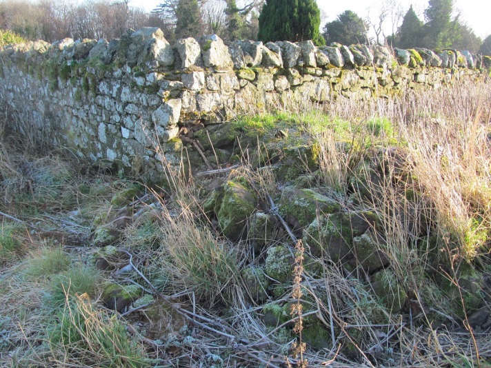
I could sense ahead of me an impenetrable wall of trees, and a wall, a wall bounding a cemetery, the cemetery slipping downhill from a church on a mound. The corner of the cemetery wall jutted into the cursus interior, a geometrical assault on the organic earthwork, a point of fusion between past and present, a boundary between the world of the living and the world of the dead, a portal between the past and present. At the base of the wall smashed vodka bottles and crushed cans had been deposited at this most powerful and liminal of locations.
I clambered over the wall and jumped down amongst the tombs and the rotting Christmas wreaths, baubled wraiths.
I built a cairn here, a time machine.

In the cemetery, grid-like paths sat awkwardly on my conception of what the cursus might have looked like here. These were incompatible realities. The dead had been buried on ancient ground, even on the ditch and bank, ghosts on top of ghosts.
Megalithic tombstones littered the graveyard.

I looked back along the cursus (never look back).
The sun dazzled me (never turn back).
Forward then, into the shadows, to the other corner of the cemetery, and a small walled off area filled with soil, a barrow made of earth dug to form fresh graves, a ramp for me to clamber up and over the wall.
Beyond, I found fake red flowers and sticky oasis at the foot of the wall, and a discarded wellington boot. Eclectic offerings.


The cursus here cuts across a patch of dense woodland, which I pushed through. This was the wildwood of prehistory, but not prehistoric, despite the improvised wooden shacks and dens, lined with tarpaulin and willow benders that clung to a field boundary wall.

I was in the trees for a minute at most, and then crossed a track, and a rough roadway, before passing some bollards and entering the lost section of the cursus, a place where it can no longer communicate to us via the medium of the cropmark.
I passed between the bollards and across the track which is essentially a long driveway to a garden centre, and passed along a lane, hemmed in on all sides by orange hedges punctuated by driveways with shiny cars and men in their boots removing, or stashing, boxes in their gaping rear ends. No-one looked at me as I consulted my map, took my photos, wrote my notes. As I moved from trees to tarmac, a murder of crows piped up from above, an ominous soundtrack accompanying my transition into the suburban cursus. Four or five white houses with oddly shaped gardens lie within this section of the cursus, while some straddle the ditch and bank, probably destroying these during construction.
Written on The Dean was the word slow: I took this entirely seriously and literally.

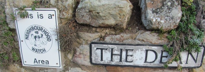
This was a middle class zone that had the feel of being a Ballardian gated community without the gates. A sign said this is a Conservation Area although its very existence has not been efficacious to the preservation of prehistoric earthworks.

Within this section of my walk my movements were entirely constrained and controlled by the urban infrastructure. I did not feel like trying to climb over 8-foot-high hedges or walking through gardens, and felt reluctant to tell householders of the unique situation of their property. And so I moved through the cursus in a curious zig-zag, until I emerged onto a main road – Preston Road – which broke the conspiracy of silence of the estate I had been in. This road runs obliquely across the cursus route.
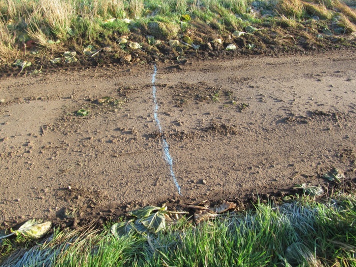
I noticed on the pavement a curious blue arrow, spray painted, and pointing away from a small drain rod point. By following the arrow I came across a proper big drain on the roadside.
![]()
I squatted and peered down into the drain, almost as if trying to look back in time, and saw myself reflected back in the dirty water below, which somehow had a rippled surface. Deep down under ground, this drain, and the system of pipes that it fed into, had been inserted right into the middle of the cursus, ripping into the monument in a way that felt much more invasive than erecting houses or laying road surfaces. The drain offered a window into the guts of the monument, maybe even beneath the cursus, a barred window back in time. The past was down there and god knows what else.

Cars roared past, and shaken, I continued my walk, down the driveway of a National Trust for Scotland property, Preston Mill. This visitor attraction is closed to the public over the winter but I walked down the red ash track, once again cutting across the line of the cursus at an unnatural angle. At a convenient point, I climbed over another wall, and began the final stage of my walk.

The final 500m or so of the cursus route was back in fields again, although the crop here was very different – not fresh healthy growth, but carnage – brussel sprout carnage. Two fields lay ahead of me, strewn with the carcasses of sprout plants, literally frozen in places despite the low cutting winter sun. The overall impression was of the aftermath of some apocalyptic Lovecraftian battle, with parts of Elder Ones and other unspeakable beings littering the fields, green tentacles and drooping fronds lightly crunching underfoot. Sprouting sprout stocks jutted from the frosty soil, with orange bubbles of sap spewing from their green musculature. The sprouts that were left behind were scattered around and felt like cold bullets.


I traipsed across the field, surrounded by yellowing leaves and infinite tiny cabbages, and the topography dipped ahead, until I reached a point where I could no longer see the far end of the field ahead where the cursus ends. A few steps up a steep slope and over a modern trackway raised by viewing position and once again the cursus route was clear. This kind of bodily and sensory engagement is what landscape phenomenology is all about, experiencing sensory restrictions which are not apparent on maps or air photos, and which may or may not relate to the intentions of the cursus builders. Stage-management of experience, or just one of those topographical variations one would expect to find along such a massive monument? Maybe the brassicas know but dead sprouts don’t tell tales.
To my right loomed a sewage plant, just beyond the southern boundary of the cursus. Like the constant sound of cars roaring by, this industrial effluence treatment plant was a modern intrusion that was tough to ignore. It also reminded me again of the drain I had peered down earlier on, and that what lies beneath is invariably unrefined shit.
Finally, after 10 minutes of solid trudging east across these fields of sprouts, I reached the place where the cursus terminates per the cropmark evidence. This was an unremarkable place, overlooked by some farm buildings, and hemmed in by hedges which restricted visibility to the east. Looking back to the southwest, I saw Traprain Law, a major East Lothian landmark and a flat-topped hill that may have had sacred significance in the Neolithic. But I could play these games all day – what could I see, what couldn’t I see, what might or might not the significance of these solipsistic visibilities be?

Another selfish walk concluded, I wandered back to my car which I had parked near the western end of the cursus in the cemetery car park. I mentally compared what I had just done with my walk of 21 years ago where my scope had been so limited, an experience that started and stopped in a field, never daring to venture beyond the edges of the rural. This confinement ultimately led to boring and unsatisfactory observations about what this place might have been all about in the Neolithic.

The walk I had just undertaken, over soil, grass, pathways, tarmac, and clambering over three walls (two more than I would normally ever countenance), following an ancient routeway that cuts across modern urban sensibilities, was an explicitly psychogeographical journey, and allowed an extended mediation on the use of land here in the ancient past and the contemporary present. This might not help us re-think the Neolithic, but it was an experience that allowed me to further reflect on my own practice and the limits of what we can say about the world as archaeologists.
Footnotes: repurposing the cursus?
Could the East Linton cursus be about to make a come-back? During 2016, a series of housing developments were proposed to the north and west of East Linton, including a new estate of over 200 homes in the field that the western Drylawhill end of the cursus is located in. This has caused concern in the village with a facebook site set up to combat ‘excessive expansion’ in the area.
A report written by Wallace Land Investment and Management, who own 34 hectares of this land, made a number of recommendations about the Drylawhill development – one of which is to ensure that no building work takes place on the route of the cursus monument. Instead, this should be left as a linear and broad green space. They note:
‘East Linton is part of an archaeological landscape. This includes [the] Scheduled Monument of the Drylawhill Cursus within the site. No development will take place on the Drylawhill Cursus site. The setting of this Scheduled Monument will be taken into account with development set back creating a buffer’.
This is connected to ‘ensuring access to important archaeological remains and provision of a new park’.

Is it possible that the demands of a society voracious for new housing and urban expansion can also accommodate prehistoric monuments in a positive way? Could we see the establishment here of a park called ‘The Cursus’, the establishment of an archaeological walking trail and expanded information for the local community, new and old, about the ancient time depth beneath their feet? How will the presence of the cursus and other prehistoric sites here be brought to the attention of people living here? The construction of housing here offers amazing challenges and opportunities.
Watch this space. I will be trying to explore how the cursus can be remade for 21st century urban living, and how we translate into modern terminology the remarkable Neolithic language of size.
