Author’s Note: New research has clarified conclusions detailed in this post, in particular the location of Peter Cromar’s memorial on the map. Please visit the following related posts for the full story:
- “New” information on Kirkton of Aboyne | A clarification of the map, and the revelation of new mysteries…
- Scotland: Day 6: Aberdeenshire: Miracles by the Dee | Journaling my cathartic visit to the Kirkton in November 2022.
Because this journal is about the real-time process of researching and developing a family history hypothesis, and not the hypothesis itself, I have decided to keep the contents unaltered, save for this caveat.

History of the site
Beyond a few turf-covered 13th century granite foundation stones and a vault constructed in the 19th century, little remains of the ancient kirk of Saint Adamnan in the Kirkton of Aboyne burial ground, also known as Formaston. The wee country kirk was dedicated to Adomnán of Iona, the ninth abbot of Iona Abbey in the west of Scotland, one of the most ancient sites associated with Christianity in Western Europe. Adomnán was active there in the late 600s, a century after its founding by Saint Columba. After his death in 704, he was styled Saint Adamnan, and among the many named in his honor, the Formaston kirk was granted to the Knights Templar and confirmed by Alexander II King of Scots around 1242.
The Formaston Stone
We can deduce that Formaston had been associated with Christianity centuries before, dating back at least to the late 800s. The most significant archaeological find on the site is the famous Formaston Stone, a fragment of an ornate granite cross slab with Ogham script lines running vertically along the right side.
The cross of which it is a fragment predates the kirk by about 400 years. It was somewhat unceremoniously repurposed under the doorstep of Saint Adamnan’s, where it was discovered sometime before the mid-1870s, suggesting the old kirk was dismantled around the 1860s. Indeed, a spate of kirk-building around that date suggests the old building had become obsolete after six centuries of use. The stone now rests on display in Aboyne at Victory Hall.


Right | The Formaston Stone. | Both images at Canmore.
The belfry
A final archaeological hint about the design of Saint Adamnan’s is an enigmatic note at the Aberdeen Council website that indicates “The old bird cage belfry wit [sic] the bell was removed and re-erected on the north side of the tower of the home farm buildings.” This evidently refers to the Mains of Aboyne, a home farm associated with Aboyne Castle, and we find said belfry in the courtyard in front of the former cart-shed and granary. Notes at Bill Harrison’s image of the structure confirm that “The birdcage bellcote was moved from Aboyne old kirk in the 1860s when the present kirk was built in the centre of the village.”
The kirk he refers to is possibly the Aboyne and Dinnet Parish Church (built 1842) or the South United Free Church (1859). Given my limited historian super-powers, I’ll hazard it was the Parish Church, given the presence of the central birdcage bellcote, an element familiar to many Church of Scotland structures.


1 | Mains of Aboyne home farm for Aboyne Castle, showing the birdcage belfry salvaged from the demolition of Saint Adamnan’s kirk in the 1860s. | Bill Harrison, 2021, geograph.uk CC-BY-SA 2.0
2 | Aboyne-Dinnet Parish Church | Stanley Howe, 2013, geograph.uk CC-BY-SA 2.0
3 | Former Free Church, Charlestown Road, Aboyne | Bill Harrison, 2021, geograph.uk CC-BY-SA 2.0
4 | Belhelvie, a church similar in scale and probably similar in design to the dismantled Saint Adamnan’s, with a similarly styled belcote. | Andrew Tryon, 2019, geograph.uk CC-BY-SA 20
George Cromar’s stone redux
In our previous post, we studied a gravestone that may have been erected in Kirkton of Aboyne just before the old kirk structure was dismantled: George Cromar’s oddly inconclusive memorial to his immediate family. Simply put, this stone creates more mystery than clarity. To recap (and add to) the mystery, we note:
- George erected the stone, most likely after daughter Mary Ann’s death in 1856, but it is unclear if he is later interred here;
- We are uncertain if Ann Meston, his wife, is interred here or elsewhere;
- We can’t confirm precise dates of death for David, Archibald, or Alexander, the three brothers who died in infancy;
- Mary Ann’s precise date on the stone is contradicted by other records by over a month;
- Most curiously, we can’t confirm the identity of the Father, Mother or Sister memorialized by the inscription;
- And we are uncertain if these unnamed family members are interred here.
We know this isn’t the only Cromar stone by far. Given the timeline suggested by the archaeological record, it is likely that Cromar families worshipped here, and many Cromars were buried in the yard while the old kirk was still in use. Many more still were buried there after the structure was dismantled. In a two century span of time from 1770 up through 1995, dozens of Cromars, husbands, brides, and children, some sadly quite young, were interred here. So where the paper record might fall short, the adjacency of these stones may fill important gaps. Though not a substitute for primary sources, an investigation of the memorials may help to connect some dots.
Alternative archaeology
It was my goal to visit the Kirkton in November as a part of our study abroad trip that vaccine hesitancy combined with the rise of Covid variants postponed. That visit would have helped in this effort, but I’m not willing to wait another year to unwind this history! I need another way to built a geography and timeline establishing links among the stones and maybe, just maybe, get past the brick wall we hit in the search for George Cromar’s origins. It turns out there is a way.
Find A Grave website contains high resolution images of Cromar memorials dating back to the elusive Peter Cromar 1690-1770. But these are discrete images, and it’s hard to establish a reliable sense of adjacencies among them. So, combined with these images, I’ve been fortunate enough to dig for and find the following evidence:
Online resources
- At the Aberdeen and North-East Scotland Family History Society website is an unbelievably important resource: the online Index to MI (Memorial Inscription) Booklets published by ANESFHS. This database allows a researcher to plug in a surname and associate it with a burial ground. When the stones are searched for, say, “Cromar” and “Kirkton of Aboyne,” it lists all the inscriptions… and the secret sauce: it associates a number with each. If the logic of this numbering system can be uncovered, it will be easy to estimate the locations of the stones with respect to one another.
- Several websites have overall photographs of the burial ground, and from these it becomes possible to analyze landmarks that allow the Find A Grave stones to be mapped, by correlating recognition of these landmarks even in the sometimes limited context provided in those images. Those shots include overall views found at Places of Worship in Scotland, a wide-angle view at The Megalithic Portal, aerial views at Canmore, contextual shots by GariochGraver at the Find A Grave page for “Aboyne – Kirkton,” and a screen-capture from the satellite imagery at Apple Maps, taken at a time of year where foliage was at a minimum (the imagery at Google or Bing is in full foliage, obscuring the ground plane). This tiny burial ground is surprisingly well-documented on the web.
The analysis
We start with a full listing of each member of the Cromar family inscribed on a stone. The fact that Scottish women maintain a maiden name throughout their lives makes this a very easy thing to track.
Index to IM Booklets
At the Index to IM Booklets, we conducted a search for only the surname “Cromar,” and for the burial ground “Kirkton of Aboyne” out of the long dropdown list. For a quick reference to all Cromar stones cataloged at ANESHFS, see the table below. For more detail, visit the spreadsheet here.
Cromars in the burial ground
| Stone: 9 | Jean Cromar | 31 Dec 1772 |
| Peter Cromar | n.d. | |
| Stone: 10 | Robert Cromar | 7 Nov 1851 |
| Elizabeth Cromar | 22 Oct 1853 | |
| John Cromar | 7 Jun 1856 | |
| Jane McCondach | 12 Jul 1875 | |
| Alexander Cromar | n.d. | |
| Stone: 11 | George Cromar | Jul 1797 |
| Helen Ogg | 6 Mar 1815 | |
| Jane Cromar | n.d. | |
| Emelia Cromar | n.d. | |
| Peter Cromar | n.d. | |
| Adam Cromar | n.d. | |
| Elizabeth Cromar | n.d. | |
| Alexander Cromar | n.d. | |
| Robert Cromar | n.d. | |
| Stone: 24 | Peter Cromar | 13 Oct 1770 |
| Stone: 27 | Peter Milne | 9 Jun 1846 |
| Catherine Cromar | 18 Oct 1865 | |
| Peter Milne | 12 Feb 1872 | |
| Elspet Ross | 4 Sep 1879 | |
| James Ross | 21 Aug 1887 | |
| Stone: 29 | James Milne | 7 Nov 1830 |
| Janet Cromar | 22 Jun 1846 | |
| Jane Milne | 26 May 1875 | |
| Stone: 35 | Mary Ann Cromar | Mar 1867 |
| Margaret Low | 20 Oct 1901 | |
| George Cromar | 16 Apr 1928 | |
| Elizabeth Cromar | 1 Jan 1935 | |
| Stone: 36 | Peter Cromar | 17 Jul 1848 |
| Mary Ann Cromar | 11 Jul 1856 | |
| Elsie Mary Cromar Ross | Mar 1995 | |
| George Cromar | n.d. | |
| Archibald Cromar | n.d. | |
| David Cromar | n.d. | |
| Alexander Cromar | n.d. | |
| Stone: 37 | Minnie Bertram | 12 Apr 1890 |
| Annie Cromar | 23 Feb 1892 | |
| Minnie Cromar | 12 Apr 1892 | |
| James Cromar | n.d. | |
| Stone: 38 | Peter Cromar | 1770 |
| Peter Cromar | 1815 | |
| Peter Cromar | 6 Jun 1856 | |
| Isabella Robertson | 21 Oct 1889 | |
| Peter Cromar | 27 Jan 1902 | |
| Fanny Cromar | 5 May 1909 | |
| Andrew Cromar | 20 Jan 1910 | |
| Isabella Cromar | 18 Dec 1914 | |
| Christian Cromar | 14 Apr 1915 | |
| James Cromar | 2 Sep 1922 | |
| James Cromar | n.d.n.d. | |
| Ann Cromar | n.d. | |
| John Cromar | n.d. | |
| Stone: 39 | Elizabeth Grieve | 11 Apr 1901 |
| Mary Ann Henderson | 26 Oct 1901 | |
| Robert Cromar | 1 Jun 1910 | |
| Farquharson Cromar | 15 Aug 1910 | |
| Stone: 44 | S.J. Dunn | 24 Oct 1916 |
| Cromar | n.d. |
Photographic resources
Next, we peruse photographic documentation of the site as a whole to identify some useful landmarks. Among the images analyzed are the following samples:


1 | Church foundation mound, view looking south-east from entrance gate. | Megalithic Portal
2 | View looking north-east at vault ruin beyond gravestones. | GariochGraver, 2015, Find A Grave
3 | View looking north at vault ruin through trees. | Places of Worship in Scotland
Middle row:
4 | View of vault looking north over slab stones. | Places of Worship in Scotland
5 | View looking west over slab stones with vault to left and tall landmark stone in background. | GariochGraver, 2015, Find A Grave
6 | View looking north-west at monument group to the east of the vault ruin (behind and right of camera). | GariochGraver, 2015, Find A Grave
Bottom row:
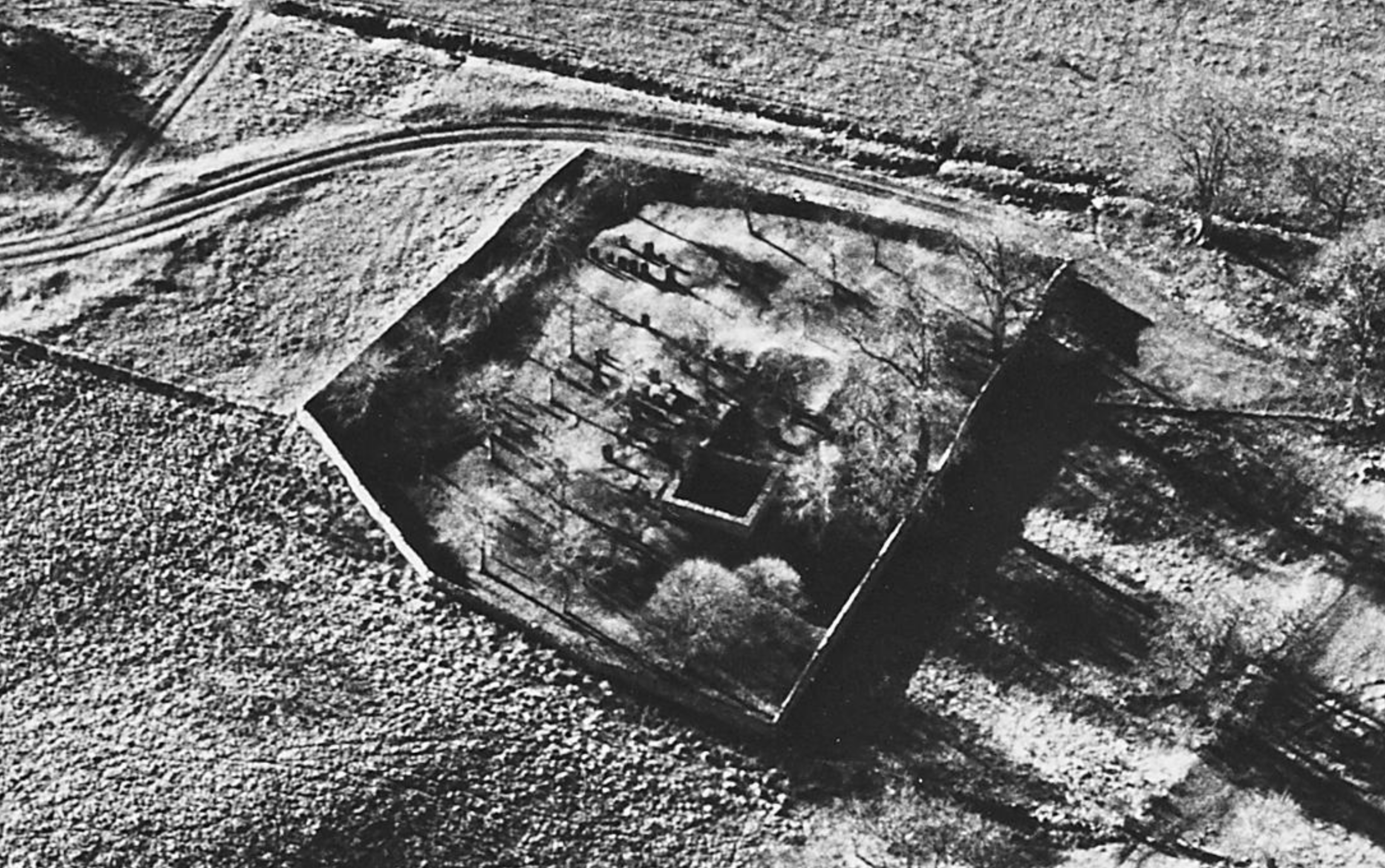
7 | Detail of aerial view from south-west. | 1995, Canmore
8 | Detail of aerial view from north-east. | 1995, Canmore
9 | Screen-capture of satellite imagery found in Apple Maps, one of the very few mapping services with a low-foliage unobstructed view of the ground plane. | Image by the author from content in map
Landmark discoveries
In the landscape we can notice several elements that stand out as significant landmarks:
- The vault ruin with kirk foundation wall: this is the most prominent feature in the landscape apart from the eccentrically shaped enclosure wall. It is visible in several ground-based images and most visible from the air in Image 8 above.
- The Grey family memorial: this is a prominent vertical stone most easily seen in Image 7 as a bright vertical line found inside the kirk foundation ruin.
- The Gordon stone: although we don’t detect this fairly recognizable red granite stone in these overall images, it can be seen in pictures of individual stones below.
- The table slab: this is a common stone typology in Scottish burial grounds, so there are a few of them here. One is a standout because it is a standalone: you can see it to the left side of Image 5.
Where these are seen in various photographs, both in the overall contextual view and among individual stones in the gallery below, positions can be roughly triangulated to estimate locations of stones. The monuments in question include any in the ANEFHS database inscribed with Cromar, in all over 60 family members on a dozen stones, from 1770 through 1995:
Cromar Stones


Second row | Stones 24, 27, and 29
Third row | Stones 35, 36, and 37
Fourth row | Stones 38, 39, and 44
All images | GariochGraver, 2015-18, Find A Grave
Triangulating relationships
Recalling our landmarks, we note their presence in these images as follows:
- Images 1, 2, and 3 show the relationship of the tall Cromar stone 38 to the taller Grey stone, and to the vault ruin.
- Adjacency of stones 9, 10, and 11 to the vault is made clear in Images 4 and 5. In Image 5 also note the presence of the Grey stone in the background.
- In the image for stone 27, note the presence of the Grey stone in the background.
- The table slab in the background of Image 5 can be seen to left of stone 35.
- The Gordon stone is seen prominently in background of images for stones 35 and 38.
- The number system can be used to deduce that stones 9, 10, and 11 are in a short row, as are stones 24, 27, and 29. Stones 35, 36, 37, 38, and 39 align in their own row.
Perspectival manipulations
With this adjacency information deduced, we can find a way to map the stones. This can be tricky. The Canmore aerial views can detect some individual stones, but is perspectivally distorted. The Apple map view is essentially an orthographic overhead view, meaning no distortion, but the resolution is too low to detect stones.
By superimposing the Canmore image on the Apple Map image, then distorting the Canmore view to align with the enclosure wall and vault ruin in the Apple view using image editing software, we can more closely pinpoint some of our landmarks.
It should be noted that it’s impossible to purge the Canmore shot of perspective entirely: walls and stones still have height! So it’s best to understand the alignment as occurring at the base of the walls and stones, which is a fairly uniform ground plane, rather than the tops of these elements, which vary greatly in height. Knowing this, we can obtain a remarkably precise match, which you can compare by dragging the slider between the two images below:


Perspectival distortion of the Canmore aerial to significant positions in the Apple satellite image, from above.
From this nifty trick, triangulation information from the all the photographs can help develop a map. It’s not precise, but it is accurate enough to understand the distribution of the stones in the burial ground:

Conclusions
This is an interesting exercise in mapping and image editing, but how is it useful? What can be inferred from what we have learned through this research and analysis? Synthesizing the proximity knowledge with documentary evidence, we can create several solid hypotheses:
Multiple diasporas
There are many branches of the family leading to multiple diasporas. The burial ground is a veritable Rosetta Stone allowing us to untangle the family migration history. In the documentary evidence this study leads us to, we find Cromar lines emigrating to Canada, Australia, New Zealand, South Africa, and the American West, in particular Colorado and Utah, then on to California and Arizona. We seem to have arrived in Aberdeenshire with Peter Cromar 1690-1770, and we seem also to have emigrated farther and wider than we’ve understood so far. The Cromar presence on the United State East Coast is evidence of merely one of many instances of emigration, both into and out of Aberdeenshire.
A close-knit family
The proximity of these stones, centered on the memorial for the patriarch Peter Cromar, suggests this is a close-knit extended family group, not a random collection of persons who coincidentally share the surname Cromar. It is not surprising that these adjacencies confirm many parent-child and brother-sister relationships instead of distant cousin links. The documentary evidence this leads us to confirms this.
Having said that, the geographic record is as remarkable for who is absent as it is for who is present. It’s surprising, for example, that we have no evidence of John Cromar 1823-1870, Ann George’s husband and George Cromar’s brother, in the burial ground. Though curious, this absence doesn’t create anomaly in the way others do: our most obvious example of this is George’s father John not in evidence, though he is memorialized anonymously on Stone 36 along with a wife and daughter.
This does provide clues to untangling their identity, however: we know that George is alive, while his father, mother, and sister are all dead, and we know the stone is erected by George sometime after 1856. This information will be useful in the documentary record if we can find death dates among the many eligible John Cromars, their wives, and their daughters. That’s a pattern that is bound to rule out many of these Johns and open up a new Cromar line, possibly breaking the current brick wall between George and the patriarch Peter. Further analysis on this will inform the next post.
Multiple Cromar lines
The most intriguing and unexpected conclusion emerges from Stone 39, however: this memorial contains Cromars who simply do not merge with other lines here. Though we are aware that absence of evidence is not evidence of absence, the Stone 39 Cromars, Robert and Farquharson, are mid-19th century to early 20th century contemporaries, not some ancient, distant echo whose records have been lost to time. They and their adjacent generations are well documented. The father in this family group, Robert Sherrat Cromar, has a confirmed line that extends back to a Peter Cromar, but not any of the ones interred here. His Peter passed in 1740 and was married to a Barbara Garrioch (pronounced geary).
We know there is a strong possibility of an unknown link between the two ancient Peters that the fog of time and memory will never allow us to see. But, given the family oral history, it is not inconceivable that the Cromar line represented in Stone 39 are “the” Cromars who originated in the Howe of Cromar, while Peter Cromar 1690-1770 and his descending lines — all the other Cromars interred here — are “imposters” who adopted the name. That begs the question: could they be the descendants of refugees, part of a diaspora originating outside of the Howe?
The lack of a connection down the line doesn’t prove this hypothesis, but it cannot be discounted. This may have been the conclusion drawn by the departed Ron Cromar, whose notes I have mentioned before and may perhaps reinforce this line of reasoning with information that simply cannot be gathered from afar.
We shall see. But in the meantime, encouraged by the breadcrumbs we’ve discovered in this study, we’ll next attempt to discover the identity of George Cromar’s father John and his family.
Leave a Reply