
Agua Fria River, Black Canyon City
Bright Angel, the Peavine, Piestewa Peak ... even casual hikers have heard of those trails. They’re well known and well traveled. But they have more than ubiquity in common. All three have been designated National Recreation Trails. Although not as exclusive as the National Scenic Trails (there are only 14 of those across the country, including the Arizona Trail), the NRTs are special. In all, there are 35 in Arizona. Some you’ve heard of. Others, maybe not. The Black Canyon NRT is one of the lesser-knowns.
The trail, which dates to the mid-1960s, runs for more than 80 miles from the Carefree Highway in Phoenix to the boundary of the Prescott National Forest, just beyond Mayer. There are several trailheads along the way. One of the easiest to get to is the Black Canyon City Trailhead. If you’ve ever headed north on Interstate 17, you’ve driven right past it. And if you’ve ever stopped at the Rock Springs Café to buy a cherry pie, you were right there. Less than a mile away.
Like any long trail that’s too long to do as a day hike, this one needs to be hiked in segments. A good introduction is the route that runs south from the Black Canyon City Trailhead.
Just beyond the gravel parking lot is a sign-in register and a metal gate. The gate itself is like any other gate. What’s different is the “bridge” to the left, which is actually a bike ramp that looks like a horizontal steel ladder with six rungs
at 45-degree angles on either end, and 17 rungs down the middle. It’s a convenient asset to the many mountain bikers who use the trail. The route, which hugs the base of the Bradshaw Mountains, is popular with equestrians, too, but the horses use the gate. Like the rest of us.
On the other side of the gate is a lush desert scene dominated by enormous saguaros. The scene is unexpected, considering its proximity to I-17. On one side is the sound of internal combustion engines. On the other is another world. A sanctuary. The contrast is distinct. Like passing through the turnstile at Magic Mountain.
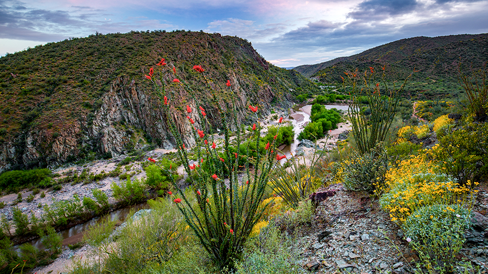
As you wind up and down and in and out of several small washes, you’ll look down into a larger canyon to the left. For a while, you might hear the faint drone of the big rigs on the freeway, but that eventually fades away and all you’ll hear are the sounds of birds and wind. The paloverdes, ocotillos and buckhorn chollas will command some attention, too. Then, about 15 minutes in, you’ll come to a wooden bench, which, like benches everywhere, is an invitation to sit. You won’t be tired, but you might want to stop and enjoy the view, which offers your first glimpse of the Aqua Fria River below. In the springtime, and during the summer monsoon, there’s a good chance you’ll see water.
From there, the trail starts switching downhill toward the river. If it’s running, you’ll start hearing it, too. After winding around a small side canyon, the route makes a heading to the west and passes through another metal gate paired with another bike ramp. Ten minutes later, you’ll arrive at the rocky edge of the river, where you would have seen herds of sheep in the middle of the last century.
The BCNRT follows a route used by prehistoric Native Americans. And a century ago, in 1919, the Department of the Interior officially established the route as a livestock driveway — it was used by woolgrowers from the Phoenix area who herded sheep to and from their summer ranges in the Bradshaw Mountains and the Black Hills. Today, the sheep are mostly gone, but the river is still there, and it makes a good turnaround point for an easy day hike. However, if you’re up for more and the river can be safely crossed, the Table Mesa Trailhead is several miles to the south. Don’t go too far, though. You still have to get back to Black Canyon City. And if you want a piece of pie, the café usually closes around 9.
Length: 3 miles round-trip
Difficulty: Easy
Elevation: 2,028 to 1,843 feet
Trailhead GPS: N 34˚03.166', W 112˚09.109'
Directions: From Anthem, go north on Interstate 17 for 12.2 miles to Black Canyon City (Exit 242). Turn left (west) and continue 0.1 miles to the stop sign. Turn right (north) onto the frontage road and continue approximately 300 feet to Warner Road (the road is not well marked). Turn left onto Warner Road and continue approximately 0.2 miles to an unmarked intersection. Turn right at the intersection and continue 0.1 miles to the trailhead.
Vehicle Requirements: None
Dogs Allowed: Yes
Horses Allowed: Yes
USGS Map: Black Canyon City
Information: Hassayampa Field Office, 623-580-5500 or www.blm.gov/arizona