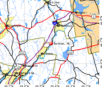
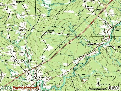
Burnham, Maine
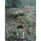
Burnham: Can you see the old man? Taken in the woods by my home on winnecook
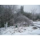
Burnham: Maine so beautiful even in the winter
- add
your


Submit your own pictures of this town and show them to the world
- OSM Map
- General Map
- Google Map
- MSN Map
Population change since 2000: +1.9%
 |
| Males: 609 | |
| Females: 555 |
| Median resident age: | 43.3 years |
| Maine median age: | 43.0 years |
Zip codes: 04922.
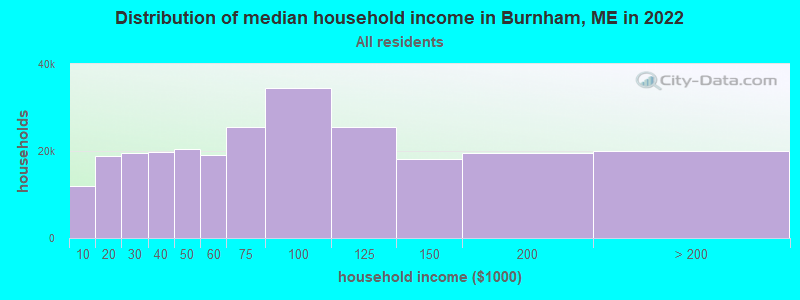
| Burnham: | $58,402 |
| ME: | $69,543 |
Estimated per capita income in 2022: $29,767 (it was $14,030 in 2000)
Burnham town income, earnings, and wages data
Estimated median house or condo value in 2022: $195,387 (it was $66,900 in 2000)
| Burnham: | $195,387 |
| ME: | $290,600 |
Mean prices in 2022: all housing units: $270,070; detached houses: $293,055; townhouses or other attached units: $325,130; in 2-unit structures: $297,158; in 3-to-4-unit structures: $211,194; in 5-or-more-unit structures: $284,526; mobile homes: $128,233; occupied boats, rvs, vans, etc.: $21,180
Detailed information about poverty and poor residents in Burnham, ME


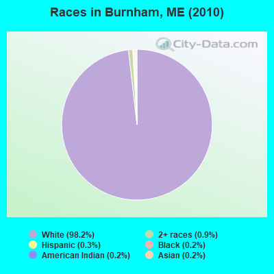
- 1,14398.2%White alone
- 110.9%Two or more races
- 40.3%Hispanic
- 20.2%Black alone
- 20.2%American Indian alone
- 20.2%Asian alone
Races in Burnham detailed stats: ancestries, foreign born residents, place of birth
According to our research of Maine and other state lists, there were 2 registered sex offenders living in Burnham, Maine as of April 30, 2024.
The ratio of all residents to sex offenders in Burnham is 582 to 1.
The ratio of registered sex offenders to all residents in this city is near the state average.
 Recent articles from our blog. Our writers, many of them Ph.D. graduates or candidates, create easy-to-read articles on a wide variety of topics.


 | SMALL HOUSES (year-round) (229 replies) |
| Checking out raw land in winter? (10 replies) |
| boiler replacement (4 replies) |
| Would-be Farmer Looking for Help (88 replies) |
| Need help planning a scouting trip to northern maine (3 replies) |
| Graham Lake Ellsworth Maine (356 replies) |
Latest news from Burnham, ME collected exclusively by city-data.com from local newspapers, TV, and radio stations
Ancestries: English (16.7%), United States (15.3%), French (14.7%), Irish (12.5%), French Canadian (4.0%), Scottish (3.9%).
Current Local Time: EST time zone
Incorporated on 02/04/1824
Elevation: 161 feet
Land area: 38.9 square miles.
Population density: 30 people per square mile (very low).
11 residents are foreign born
| This town: | 1.0% |
| Maine: | 2.9% |
| Burnham town: | 1.6% ($1,059) |
| Maine: | 1.5% ($1,417) |
Nearest city with pop. 50,000+: Portland, ME  (82.8 miles , pop. 64,249).
Nearest city with pop. 200,000+: Boston, MA (184.2 miles , pop. 589,141).
Nearest city with pop. 1,000,000+: Bronx, NY (349.6 miles , pop. 1,332,650).
Nearest cities:
), ), ), ), ), ), Latitude: 44.68 N, Longitude: 69.38 W
Area code commonly used in this area: 207

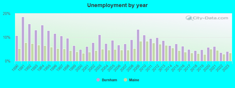
| Here: | 4.1% |
| Maine: | 3.4% |
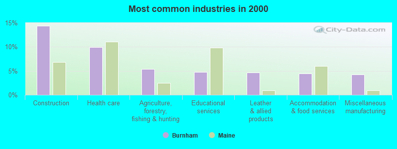
- Construction (14.4%)
- Health care (10.0%)
- Agriculture, forestry, fishing & hunting (5.4%)
- Educational services (4.8%)
- Leather & allied products (4.6%)
- Accommodation & food services (4.4%)
- Miscellaneous manufacturing (4.2%)
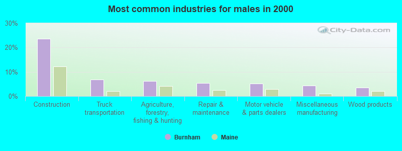
- Construction (23.6%)
- Truck transportation (6.9%)
- Agriculture, forestry, fishing & hunting (6.2%)
- Repair & maintenance (5.4%)
- Motor vehicle & parts dealers (5.1%)
- Miscellaneous manufacturing (4.3%)
- Wood products (3.6%)
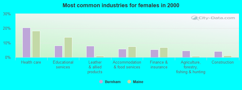
- Health care (20.4%)
- Educational services (8.2%)
- Leather & allied products (7.8%)
- Accommodation & food services (5.7%)
- Finance & insurance (5.3%)
- Agriculture, forestry, fishing & hunting (4.5%)
- Construction (4.1%)
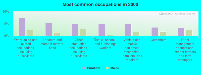
- Other sales and related occupations, including supervisors (7.3%)
- Laborers and material movers, hand (5.4%)
- Other production occupations, including supervisors (4.8%)
- Textile, apparel, and furnishings workers (4.8%)
- Vehicle and mobile equipment mechanics, installers, and repairers (4.8%)
- Carpenters (3.5%)
- Other management occupations, except farmers and farm managers (3.3%)
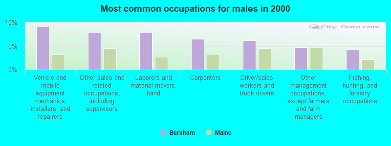
- Vehicle and mobile equipment mechanics, installers, and repairers (9.1%)
- Other sales and related occupations, including supervisors (8.0%)
- Laborers and material movers, hand (8.0%)
- Carpenters (6.5%)
- Driver/sales workers and truck drivers (6.2%)
- Other management occupations, except farmers and farm managers (4.7%)
- Fishing, hunting, and forestry occupations (4.3%)
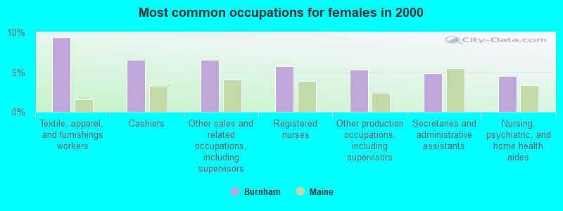
- Textile, apparel, and furnishings workers (9.4%)
- Cashiers (6.5%)
- Other sales and related occupations, including supervisors (6.5%)
- Registered nurses (5.7%)
- Other production occupations, including supervisors (5.3%)
- Secretaries and administrative assistants (4.9%)
- Nursing, psychiatric, and home health aides (4.5%)
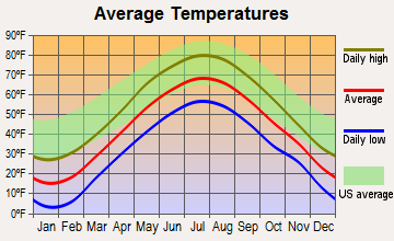
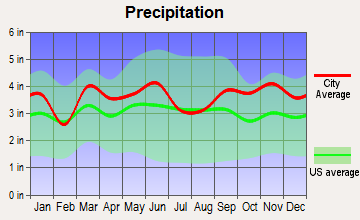
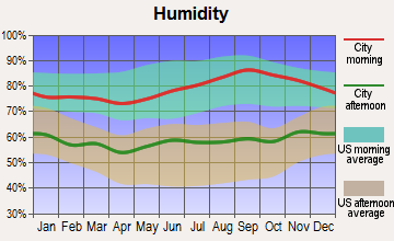
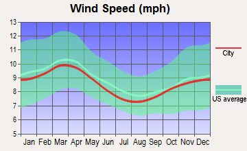
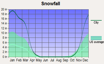
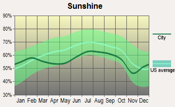
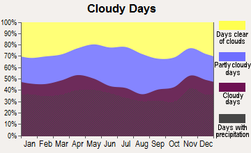
Average climate in Burnham, Maine
Based on data reported by over 4,000 weather stations
Earthquake activity:
Burnham-area historical earthquake activity is significantly above Maine state average. It is 78% smaller than the overall U.S. average.On 4/20/2002 at 10:50:47, a magnitude 5.3 (5.3 ML, Depth: 3.0 mi, Class: Moderate, Intensity: VI - VII) earthquake occurred 212.7 miles away from Burnham center
On 10/16/2012 at 23:12:25, a magnitude 4.7 (4.7 ML, Depth: 10.0 mi, Class: Light, Intensity: IV - V) earthquake occurred 98.0 miles away from the city center
On 4/20/2002 at 10:50:47, a magnitude 5.2 (5.2 MB, 4.2 MS, 5.2 MW, 5.0 MW) earthquake occurred 213.9 miles away from Burnham center
On 10/7/1983 at 10:18:46, a magnitude 5.3 (5.1 MB, 5.3 LG, 5.1 ML) earthquake occurred 250.4 miles away from Burnham center
On 1/19/1982 at 00:14:42, a magnitude 4.7 (4.5 MB, 4.7 MD, 4.5 LG) earthquake occurred 137.1 miles away from Burnham center
On 2/26/1999 at 03:38:43, a magnitude 3.8 (3.8 LG, Depth: 2.0 mi, Class: Light, Intensity: II - III) earthquake occurred 15.4 miles away from Burnham center
Magnitude types: regional Lg-wave magnitude (LG), body-wave magnitude (MB), duration magnitude (MD), local magnitude (ML), surface-wave magnitude (MS), moment magnitude (MW)
Natural disasters:
The number of natural disasters in Waldo County (19) is greater than the US average (15).Major Disasters (Presidential) Declared: 15
Emergencies Declared: 3
Causes of natural disasters: Floods: 14, Storms: 11, Snows: 3, Heavy Rains: 2, Winter Storms: 2, Blizzard: 1, Hurricane: 1, Ice Storm: 1, Landslide: 1, Snowfall: 1, Wind: 1, Other: 1 (Note: some incidents may be assigned to more than one category).
Hospitals and medical centers near Burnham:
- BIRCH GROVE REHAB AND LIVING CTR (Nursing Home, about 8 miles away; PITTSFIELD, ME)
- PITTSFIELD REHAB AND NURSING (Nursing Home, about 8 miles away; PITTSFIELD, ME)
- SEBASTICOOK VALLEY HOSPITAL Critical Access Hospitals (about 8 miles away; PITTSFIELD, ME)
- HEALTHREACH HOSPICE (Hospital, about 15 miles away; WATERVILLE, ME)
- MOUNT ST JOSEPH NURSING HOME (Nursing Home, about 15 miles away; WATERVILLE, ME)
- SANFIELD REHAB AND LIVING CENTER (Nursing Home, about 15 miles away; HARTLAND, ME)
- WILLOWS NURSING CARE CENTER (Nursing Home, about 15 miles away; WATERVILLE, ME)
Colleges/universities with over 2000 students nearest to Burnham:
- Husson University (about 31 miles; Bangor, ME; Full-time enrollment: 2,421)
- University of Maine at Augusta (about 32 miles; Augusta, ME; FT enrollment: 3,204)
- University of Maine at Farmington (about 38 miles; Farmington, ME; FT enrollment: 2,036)
- University of Maine (about 38 miles; Orono, ME; FT enrollment: 8,931)
- Saint Joseph's College of Maine (about 81 miles; Standish, ME; FT enrollment: 2,010)
- Southern Maine Community College (about 83 miles; South Portland, ME; FT enrollment: 4,666)
- University of Southern Maine (about 84 miles; Portland, ME; FT enrollment: 6,647)
User-submitted facts and corrections:
- Burnham village school is no longer k-2 it is only kidnergardres from the whole school distrit.
Points of interest:
Notable locations in Burnham: Burnham Fire Department Station 2 (A), Burnham Fire Department Station 1 (B). Display/hide their locations on the map
Cemeteries: Village Cemetery (1), Reynolds Cemetery (2), Chandler Cemetery (3), Mudgett Cemetery (4), Mount Cemetery (5). Display/hide their locations on the map
Swamps: Chain Meadows (A). Display/hide its location on the map
Streams, rivers, and creeks: Twentyfive Mile Stream (A), Spring Brook (B), Meadow Brook (C), Carlton Stream (D). Display/hide their locations on the map
Drinking water stations with addresses in Burnham and their reported violations in the past:
PRIDE MANUFACTURING #1 (Population served: 150, Groundwater):Past health violations:PRIDE MANUFACTURING #2 (Population served: 150, Groundwater):Past monitoring violations:
- MCL, Monthly (TCR) - In MAY-2012, Contaminant: Coliform. Follow-up actions: St Public Notif requested (JUN-13-2012), St Formal NOV issued (JUN-13-2012), St Public Notif received (JUN-28-2012), St Compliance achieved (JAN-13-2014)
- MCL, Monthly (TCR) - In APR-2012, Contaminant: Coliform. Follow-up actions: St Public Notif requested (APR-30-2012), St Formal NOV issued (APR-30-2012), St Public Notif received (MAY-03-2012), St Compliance achieved (JAN-13-2014)
- MCL, Monthly (TCR) - In JAN-2012, Contaminant: Coliform. Follow-up actions: St Public Notif requested (FEB-03-2012), St Formal NOV issued (FEB-03-2012), St Public Notif received (FEB-16-2012), St Compliance achieved (JAN-13-2014)
- MCL, Monthly (TCR) - In DEC-2011, Contaminant: Coliform. Follow-up actions: St Public Notif requested (DEC-16-2011), St Formal NOV issued (DEC-16-2011), St Public Notif received (JAN-06-2012), St Compliance achieved (JAN-13-2014)
- MCL, Monthly (TCR) - In NOV-2011, Contaminant: Coliform. Follow-up actions: St Public Notif requested (NOV-14-2011), St Formal NOV issued (NOV-14-2011), St Public Notif received (NOV-29-2011), St Compliance achieved (JAN-13-2014)
- MCL, Monthly (TCR) - In AUG-2010, Contaminant: Coliform. Follow-up actions: St Public Notif requested (AUG-16-2010), St Formal NOV issued (AUG-16-2010), St Public Notif received (AUG-24-2010), St Compliance achieved (MAY-09-2011)
- Monitoring, Repeat Major (TCR) - In JAN-2005, Contaminant: Coliform (TCR). Follow-up actions: St Public Notif requested (FEB-08-2005), St Violation/Reminder Notice (FEB-08-2005), St Public Notif received (2 times from FEB-22-2005 to FEB-22-2005), St Compliance achieved (DEC-21-2005)
- One routine major monitoring violation
Past monitoring violations:LAKEVIEW GOLF CLUB (Population served: 125, Groundwater):
- 2 routine major monitoring violations
Past health violations:Past monitoring violations:
- MCL, Monthly (TCR) - In JUL-2010, Contaminant: Coliform. Follow-up actions: St Public Notif requested (AUG-10-2010), St Formal NOV issued (AUG-10-2010), St Public Notif received (2 times from SEP-08-2010 to MAR-09-2011), St Compliance achieved (MAR-29-2011)
- 5 routine major monitoring violations
| This town: | 2.3 people |
| Maine: | 2.3 people |
| This town: | 66.1% |
| Whole state: | 62.9% |
| This town: | 9.8% |
| Whole state: | 9.4% |
Likely homosexual households (counted as self-reported same-sex unmarried-partner households)
- Lesbian couples: 0.6% of all households
- Gay men: 0.0% of all households
| This town: | 16.0% |
| Whole state: | 10.9% |
| This town: | 7.1% |
| Whole state: | 4.1% |
For population 15 years and over in Burnham:
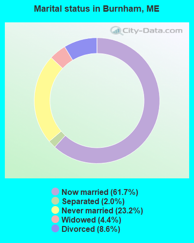
- Never married: 23.2%
- Now married: 61.7%
- Separated: 2.0%
- Widowed: 4.4%
- Divorced: 8.6%
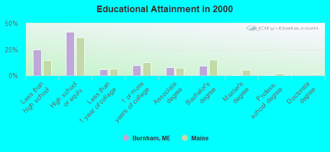
For population 25 years and over in Burnham:
- High school or higher: 75.3%
- Bachelor's degree or higher: 10.2%
- Graduate or professional degree: 0.8%
- Unemployed: 7.1%
- Mean travel time to work (commute): 27.9 minutes
| Here: | 10.2 |
| Maine average: | 11.2 |
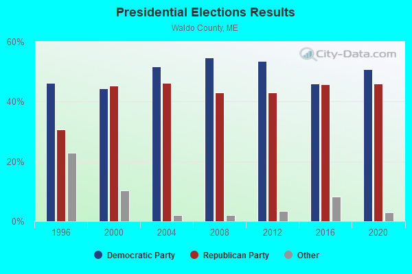
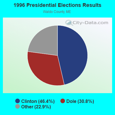
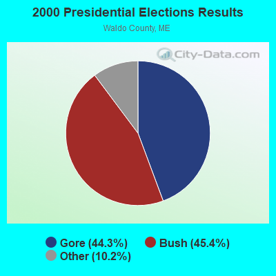
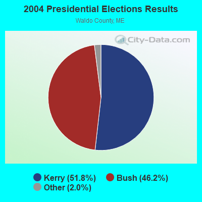
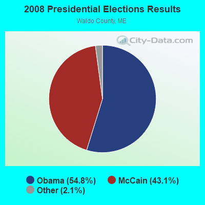
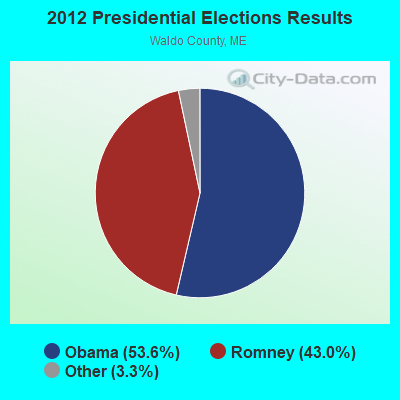
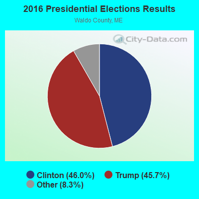
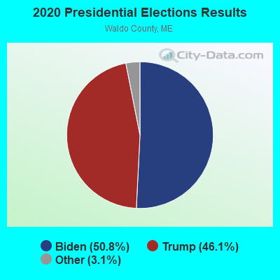
Graphs represent county-level data. Detailed 2008 Election Results
Religion statistics for Burnham, ME (based on Waldo County data)
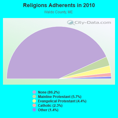
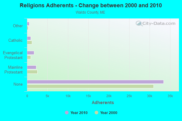
| Religion | Adherents | Congregations |
|---|---|---|
| Mainline Protestant | 2,204 | 20 |
| Evangelical Protestant | 1,711 | 23 |
| Catholic | 900 | 3 |
| Other | 554 | 7 |
| None | 33,417 | - |
Food Environment Statistics:
| Waldo County: | 2.60 / 10,000 pop. |
| Maine: | 2.80 / 10,000 pop. |
| Waldo County: | 1.82 / 10,000 pop. |
| Maine: | 2.20 / 10,000 pop. |
| Waldo County: | 7.02 / 10,000 pop. |
| State: | 5.75 / 10,000 pop. |
| Waldo County: | 8.84 / 10,000 pop. |
| Maine: | 11.02 / 10,000 pop. |
| This county: | 9.2% |
| State: | 8.2% |
| Waldo County: | 26.1% |
| Maine: | 25.0% |
Strongest AM radio stations in Burnham:
- WSKW (1160 AM; 10 kW; SKOWHEGAN, ME; Owner: MOUNTAIN WIRELESS, INCORPORATED)
- WZON (620 AM; 5 kW; BANGOR, ME; Owner: THE ZONE CORPORATION)
- WABI (910 AM; 5 kW; BANGOR, ME; Owner: CLEAR CHANNEL BROADCASTING LICENSES, INC.)
- WTME (780 AM; 10 kW; RUMFORD, ME; Owner: MOUNTAIN VALLEY BROADCASTING, INC.)
- WTVL (1490 AM; 1 kW; WATERVILLE, ME; Owner: CITADEL BROADCASTING COMPANY)
- WFAU (1280 AM; 5 kW; GARDINER, ME; Owner: CAPSTAR TX LIMITED PARTNERSHIP)
- WRKO (680 AM; 50 kW; BOSTON, MA; Owner: ENTERCOM BOSTON LICENSE, LLC)
- WDEA (1370 AM; 5 kW; ELLSWORTH, ME; Owner: CUMULUS LICENSING CORP.)
- WEEI (850 AM; 50 kW; BOSTON, MA; Owner: ENTERCOM BOSTON LICENSE, LLC)
- WBZ (1030 AM; 50 kW; BOSTON, MA; Owner: INFINITY BROADCASTING OPERATIONS, INC.)
- WMTW (870 AM; 10 kW; GORHAM, ME; Owner: RADIO PARTNERS OF MAINE, L.P.)
- WCRN (830 AM; 50 kW; WORCESTER, MA; Owner: CARTER BROADCASTING CORPORATION)
- WNNZ (640 AM; 50 kW; WESTFIELD, MA; Owner: CLEAR CHANNEL BROADCASTING LICENSES, INC.)
Strongest FM radio stations in Burnham:
- WWBX (97.1 FM; BANGOR, ME; Owner: CLEAR CHANNEL BROADCASTING LICENSES, INC.)
- WCTB (93.5 FM; FAIRFIELD, ME; Owner: MOUNTAIN WIRELESS, INC.)
- WHQO (107.9 FM; SKOWHEGAN, ME; Owner: MOUNTAIN WIRELESS, INC.)
- WBFB (104.7 FM; BELFAST, ME; Owner: CLEAR CHANNEL BROADCASTING LICENSES, INC.)
- WWWA (95.3 FM; WINSLOW, ME; Owner: LIGHT OF LIFE MINISTRIES, INC.)
- WQCB (106.5 FM; BREWER, ME; Owner: CUMULUS LICENSING CORP.)
- WTOS-FM (105.1 FM; SKOWHEGAN, ME; Owner: CAPSTAR TX LIMITED PARTNERSHIP)
- WJCX (99.5 FM; PITTSFIELD, ME; Owner: CSN INTERNATIONAL)
- WMEP (90.5 FM; CAMDEN, ME; Owner: MAINE PUBLIC BROADCASTING CORP.)
- WQSS (102.5 FM; CAMDEN, ME; Owner: CLEAR CHANNEL BROADCASTING LICENSES, INC.)
- WFZX (101.7 FM; SEARSPORT, ME; Owner: CLEAR CHANNEL BROADCASTING LICENSES, INC.)
- WGUY (102.1 FM; DEXTER, ME; Owner: CONCORD MEDIA GROUP, INC.)
- WEBB (98.5 FM; WATERVILLE, ME; Owner: CITADEL BROADCASTING COMPANY)
- WKIT-FM (100.3 FM; BREWER, ME; Owner: THE ZONE CORPORATION)
- WWMJ (95.7 FM; ELLSWORTH, ME; Owner: CUMULUS LICENSING CORP.)
- WVOM (103.9 FM; HOWLAND, ME; Owner: CLEAR CHANNEL BROADCASTING LICENSES, INC.)
- WMEH (90.9 FM; BANGOR, ME; Owner: MAINE PUBLIC BROADCASTING CORPORATION)
- WMEW (91.3 FM; WATERVILLE, ME; Owner: MAINE PUBLIC BROADCASTING CORPORATION)
- WMME-FM (92.3 FM; AUGUSTA, ME; Owner: CITADEL BROADCASTING COMPANY)
TV broadcast stations around Burnham:
- WABI-TV (Channel 5; BANGOR, ME; Owner: COMMUNITY BROADCASTING SERVICE)
- W36CK (Channel 36; BANGOR, ME; Owner: TRINITY BROADCASTING NETWORK)
- WFYW-LP (Channel 69; FAIRFIELD/WATERVILLE, ME; Owner: THREE ANGELS BROADCASTING NETWORK, INC.)
- DW23AB (Channel 23; WATERVILLE, ME; Owner: RUSSELL COMMUNICATIONS)
- Burnham, Maine
- Fatal accident count8
- Vehicles involved in fatal accidents10
- Fatal accidents involving drunk persons:5
- Fatalities10
- Persons involved in fatal accidents21
- Pedestrians involved in fatal accidents0
- Maine average
- Fatal accident count1101
- Vehicles involved in fatal accidents1585
- Fatal accidents involving drunk persons392
- Fatalities1219
- Persons involved in fatal accidents2687
- Pedestrians involved in fatal accidents64
- National Bridge Inventory (NBI) Statistics
- 4Number of bridges
- 52ft / 16.1mTotal length
- 5,057Total average daily traffic
- 252Total average daily truck traffic
- 7,399Total future (year 2036) average daily traffic
FCC Registered Antenna Towers:
3- Edward G Roach, 63 Johnson Flat Rd (Me05781-S) (Lat: 44.692333 Lon: -69.435917), Type: 60.7, Overall height: 57.9 m, Registrant: Sba Properties, Inc., Eroach@sbasite.Com, , Boca -Raton, Phone: (561) 995-7670
- Edward G Roach, 63 Johnson Flat Rd (Me05781-S) (Lat: 44.692333 Lon: -69.435917), Type: 60.7, Overall height: 57.9 m, Registrant: Sba Properties, Inc., Eroach@sbasite.Com, , Boca -Raton, Phone: (561) 995-7670
- Edward G Roach, 63 Johnson Flat Rd (Me05781-S) (Lat: 44.692333 Lon: -69.435917), Type: 60.7, Structure height: 23027 m, Overall height: 57.9 m, Registrant: Sba Properties, LLC, Eroach@sbasite.Com, , Boca -Raton, Phone: (561) 995-7670
FCC Registered Broadcast Land Mobile Towers:
1- Int Battle St & Troy Burnham Rd (Lat: 44.689222 Lon: -69.420611), Type: Tower, Structure height: 11.6 m, Overall height: 15.2 m, Call Sign: KAQ542,
Assigned Frequencies: 154.310 MHz, 154.355 MHz, Grant Date: 02/03/2023, Expiration Date: 03/30/2033, Registrant: Yankee Communications Inc, 263 Neck Rd, Waterville, ME 04901, Phone: (207) 453-2000, Fax: (207) 453-9670, Email:
FCC Registered Amateur Radio Licenses:
12 (See the full list of FCC Registered Amateur Radio Licenses in Burnham)FAA Registered Aircraft:
1- Aircraft: AERONCA 65-LA (Category: Land, Seats: 2, Weight: Up to 12,499 Pounds, Speed: 75 mph), Engine: Reciprocating
N-Number: 23958, N23958, N-23958, Serial Number: L6129, Certificate Issue Date: 05/21/2001
Registrant (Individual): Clifford E Palmer, 31 Morgan Rd, Burnham, ME 04922
Deregistered: Cancel Date: 03/12/2018
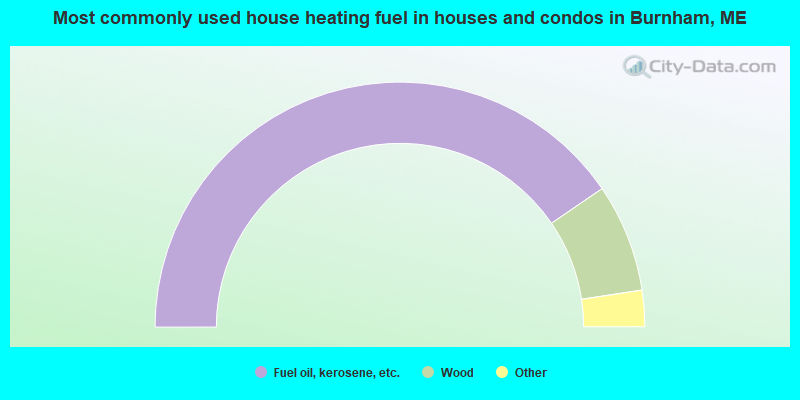
- 80.9%Fuel oil, kerosene, etc.
- 14.3%Wood
- 3.7%Bottled, tank, or LP gas
- 0.5%Electricity
- 0.5%Other fuel
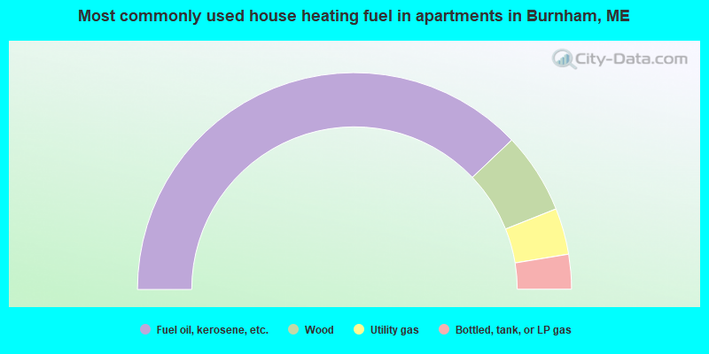
- 75.9%Fuel oil, kerosene, etc.
- 12.1%Wood
- 6.9%Utility gas
- 5.2%Bottled, tank, or LP gas
Burnham compared to Maine state average:
- Unemployed percentage below state average.
- Black race population percentage significantly below state average.
- Hispanic race population percentage significantly below state average.
- Foreign-born population percentage significantly below state average.
- Renting percentage below state average.
- Length of stay since moving in significantly above state average.
- Number of rooms per house significantly below state average.
- House age significantly below state average.
- Number of college students below state average.
- Percentage of population with a bachelor's degree or higher significantly below state average.