Chesterville, Maine

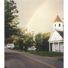
Chesterville: Sand Pond The End Of The Rainbow
Chesterville: Chesterville Church
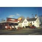
Chesterville: North Chesterville Maine - Village Market And Schoolhouse
- add
your


Submit your own pictures of this town and show them to the world
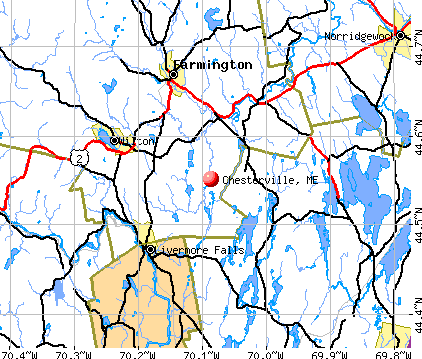
- OSM Map
- General Map
- Google Map
- MSN Map
Population change since 2000: +15.6%
 |
| Males: 668 | |
| Females: 684 |
| Median resident age: | 44.1 years |
| Maine median age: | 43.0 years |
Zip codes: 04938.
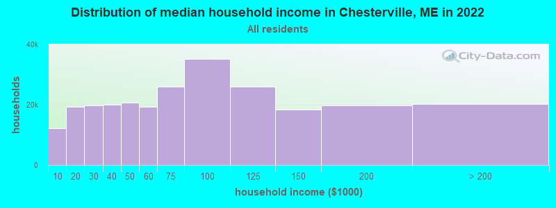
| Chesterville: | $58,159 |
| ME: | $69,543 |
Estimated per capita income in 2022: $33,474 (it was $15,376 in 2000)
Chesterville town income, earnings, and wages data
Estimated median house or condo value in 2022: $173,587 (it was $65,400 in 2000)
| Chesterville: | $173,587 |
| ME: | $290,600 |
Mean prices in 2022: all housing units: $249,382; detached houses: $272,823; townhouses or other attached units: $269,365; in 2-unit structures: $215,792; in 3-to-4-unit structures: $159,774; in 5-or-more-unit structures: $237,338; mobile homes: $71,957
Detailed information about poverty and poor residents in Chesterville, ME


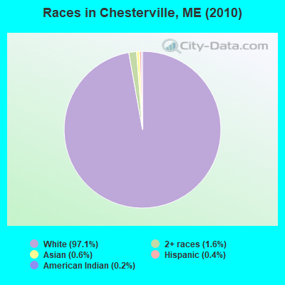
- 1,31397.1%White alone
- 211.6%Two or more races
- 80.6%Asian alone
- 50.4%Hispanic
- 30.2%American Indian alone
- 10.07%Black alone
- 10.07%Other race alone
Races in Chesterville detailed stats: ancestries, foreign born residents, place of birth
According to our research of Maine and other state lists, there were 2 registered sex offenders living in Chesterville, Maine as of April 30, 2024.
The ratio of all residents to sex offenders in Chesterville is 676 to 1.
The ratio of registered sex offenders to all residents in this city is lower than the state average.
 Recent articles from our blog. Our writers, many of them Ph.D. graduates or candidates, create easy-to-read articles on a wide variety of topics.


 | Maine weather thread (3207 replies) |
| Maine's Own Off-Topic Thread! (2485 replies) |
| Looking for a home in Wilton, ME (22 replies) |
Latest news from Chesterville, ME collected exclusively by city-data.com from local newspapers, TV, and radio stations
Ancestries: English (19.8%), Irish (17.9%), United States (16.2%), French (10.3%), German (6.2%), French Canadian (5.0%).
Current Local Time: EST time zone
Incorporated on 02/20/1802
Elevation: 360 feet
Land area: 36.5 square miles.
Population density: 37 people per square mile (very low).
19 residents are foreign born
| This town: | 1.6% |
| Maine: | 2.9% |
| Chesterville town: | 1.3% ($861) |
| Maine: | 1.5% ($1,417) |
Nearest city with pop. 50,000+: Portland, ME  (61.9 miles , pop. 64,249).
Nearest city with pop. 200,000+: Boston, MA (162.2 miles , pop. 589,141).
Nearest city with pop. 1,000,000+: Bronx, NY (320.4 miles , pop. 1,332,650).
Nearest cities:
), ), ), ), Latitude: 44.55 N, Longitude: 70.09 W
Area code commonly used in this area: 207

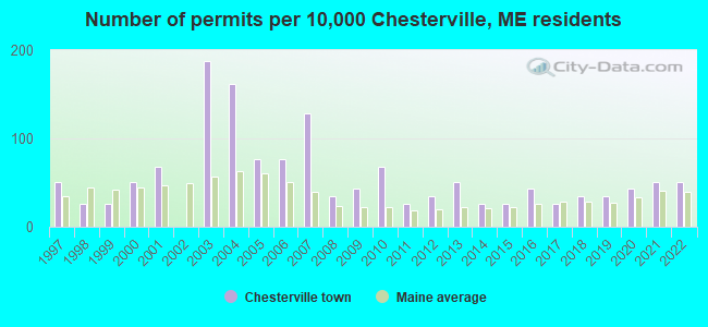
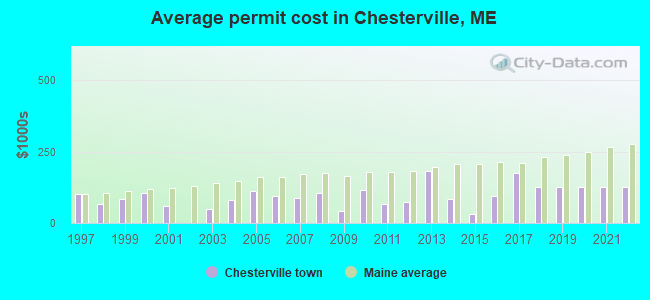
Single-family new house construction building permits:
- 2022: 6 buildings, average cost: $125,000
- 2021: 6 buildings, average cost: $125,000
- 2020: 5 buildings, average cost: $125,000
- 2019: 4 buildings, average cost: $125,000
- 2018: 4 buildings, average cost: $125,000
- 2017: 3 buildings, average cost: $175,000
- 2016: 5 buildings, average cost: $95,000
- 2015: 3 buildings, average cost: $31,300
- 2014: 3 buildings, average cost: $82,700
- 2013: 6 buildings, average cost: $182,900
- 2012: 4 buildings, average cost: $72,500
- 2011: 3 buildings, average cost: $66,700
- 2010: 8 buildings, average cost: $116,800
- 2009: 5 buildings, average cost: $41,200
- 2008: 4 buildings, average cost: $104,300
- 2007: 15 buildings, average cost: $89,300
- 2006: 9 buildings, average cost: $93,900
- 2005: 9 buildings, average cost: $110,700
- 2004: 19 buildings, average cost: $80,500
- 2003: 22 buildings, average cost: $47,800
- 2001: 8 buildings, average cost: $60,500
- 2000: 6 buildings, average cost: $105,900
- 1999: 3 buildings, average cost: $84,800
- 1998: 3 buildings, average cost: $65,700
- 1997: 6 buildings, average cost: $101,300
| Here: | 4.2% |
| Maine: | 3.4% |
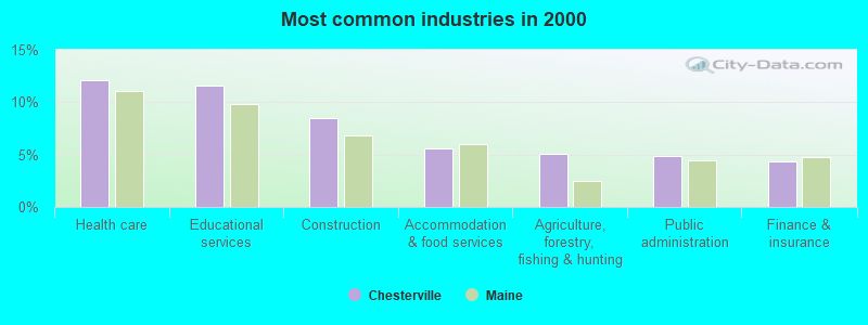
- Health care (12.2%)
- Educational services (11.6%)
- Construction (8.5%)
- Accommodation & food services (5.6%)
- Agriculture, forestry, fishing & hunting (5.0%)
- Public administration (4.9%)
- Finance & insurance (4.3%)
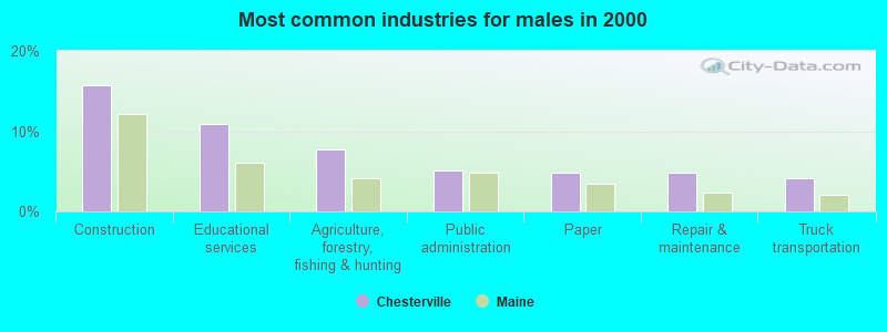
- Construction (15.8%)
- Educational services (10.9%)
- Agriculture, forestry, fishing & hunting (7.7%)
- Public administration (5.1%)
- Paper (4.8%)
- Repair & maintenance (4.8%)
- Truck transportation (4.2%)
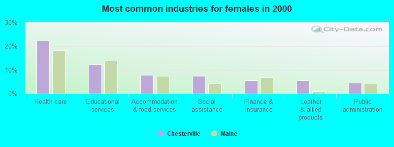
- Health care (22.3%)
- Educational services (12.5%)
- Accommodation & food services (7.9%)
- Social assistance (7.5%)
- Finance & insurance (5.7%)
- Leather & allied products (5.7%)
- Public administration (4.5%)
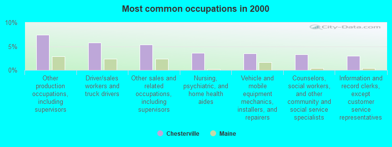
- Other production occupations, including supervisors (7.5%)
- Driver/sales workers and truck drivers (5.7%)
- Other sales and related occupations, including supervisors (5.4%)
- Nursing, psychiatric, and home health aides (3.6%)
- Vehicle and mobile equipment mechanics, installers, and repairers (3.5%)
- Counselors, social workers, and other community and social service specialists (3.3%)
- Information and record clerks, except customer service representatives (3.0%)
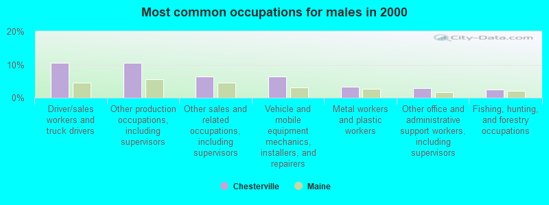
- Driver/sales workers and truck drivers (10.6%)
- Other production occupations, including supervisors (10.6%)
- Other sales and related occupations, including supervisors (6.4%)
- Vehicle and mobile equipment mechanics, installers, and repairers (6.4%)
- Metal workers and plastic workers (3.2%)
- Other office and administrative support workers, including supervisors (2.9%)
- Fishing, hunting, and forestry occupations (2.6%)
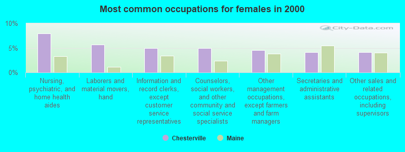
- Nursing, psychiatric, and home health aides (7.9%)
- Laborers and material movers, hand (5.7%)
- Information and record clerks, except customer service representatives (4.9%)
- Counselors, social workers, and other community and social service specialists (4.9%)
- Other management occupations, except farmers and farm managers (4.5%)
- Secretaries and administrative assistants (4.2%)
- Other sales and related occupations, including supervisors (4.2%)
Average climate in Chesterville, Maine
Based on data reported by over 4,000 weather stations


(lower is better)
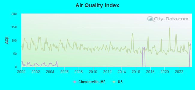
Air Quality Index (AQI) level in 2004 was 9.46. This is significantly better than average.
| City: | 9.46 |
| U.S.: | 72.56 |
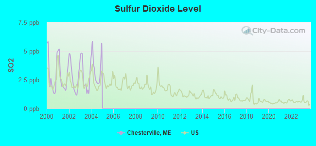
Sulfur Dioxide (SO2) [ppb] level in 2004 was 3.52. This is significantly worse than average. Closest monitor was 7.2 miles away from the city center.
| City: | 3.52 |
| U.S.: | 1.51 |
Earthquake activity:
Chesterville-area historical earthquake activity is significantly above Maine state average. It is 76% smaller than the overall U.S. average.On 4/20/2002 at 10:50:47, a magnitude 5.3 (5.3 ML, Depth: 3.0 mi, Class: Moderate, Intensity: VI - VII) earthquake occurred 178.1 miles away from Chesterville center
On 10/16/2012 at 23:12:25, a magnitude 4.7 (4.7 ML, Depth: 10.0 mi, Class: Light, Intensity: IV - V) earthquake occurred 71.8 miles away from Chesterville center
On 4/20/2002 at 10:50:47, a magnitude 5.2 (5.2 MB, 4.2 MS, 5.2 MW, 5.0 MW) earthquake occurred 179.2 miles away from Chesterville center
On 10/7/1983 at 10:18:46, a magnitude 5.3 (5.1 MB, 5.3 LG, 5.1 ML) earthquake occurred 214.9 miles away from the city center
On 1/19/1982 at 00:14:42, a magnitude 4.7 (4.5 MB, 4.7 MD, 4.5 LG) earthquake occurred 104.7 miles away from Chesterville center
On 2/26/1999 at 03:38:43, a magnitude 3.8 (3.8 LG, Depth: 2.0 mi, Class: Light, Intensity: II - III) earthquake occurred 28.3 miles away from the city center
Magnitude types: regional Lg-wave magnitude (LG), body-wave magnitude (MB), duration magnitude (MD), local magnitude (ML), surface-wave magnitude (MS), moment magnitude (MW)
Natural disasters:
The number of natural disasters in Franklin County (27) is a lot greater than the US average (15).Major Disasters (Presidential) Declared: 19
Emergencies Declared: 7
Causes of natural disasters: Floods: 16, Storms: 14, Snows: 7, Heavy Rains: 2, Hurricanes: 2, Blizzard: 1, Ice Storm: 1, Landslide: 1, Snowfall: 1, Tropical Storm: 1, Wind: 1, Winter Storm: 1, Other: 2 (Note: some incidents may be assigned to more than one category).

Hospitals and medical centers near Chesterville:
- SANDY RIVER CENTER (Nursing Home, about 6 miles away; FARMINGTON, ME)
- ORCHARD PARK REHAB AND LIVING (Nursing Home, about 10 miles away; FARMINGTON, ME)
- EDGEWOOD REHAB AND LIVING CTR (Nursing Home, about 11 miles away; FARMINGTON, ME)
- VICTORIAN VILLA NURSING HOME (Nursing Home, about 14 miles away; CANTON, ME)
Colleges/universities with over 2000 students nearest to Chesterville:
- University of Maine at Farmington (about 9 miles; Farmington, ME; Full-time enrollment: 2,036)
- University of Maine at Augusta (about 21 miles; Augusta, ME; FT enrollment: 3,204)
- Saint Joseph's College of Maine (about 54 miles; Standish, ME; FT enrollment: 2,010)
- University of Southern Maine (about 63 miles; Portland, ME; FT enrollment: 6,647)
- Southern Maine Community College (about 63 miles; South Portland, ME; FT enrollment: 4,666)
- Husson University (about 67 miles; Bangor, ME; FT enrollment: 2,421)
- University of Maine (about 74 miles; Orono, ME; FT enrollment: 8,931)
Points of interest:
Notable location: Chesterville Volunteer Fire Department (A). Display/hide its location on the map
Cemeteries: Norcross Cemetery (1), Lowell Cemetery (2), Borough Cemetery (3), Chesterville Hill Cemetery (4), Center Cemetery (5), Zion Hill Cemetery (6), Soper Cemetery (7). Display/hide their locations on the map
Lakes and reservoirs: Crowell Pond (A), Fellows Pond (B), Horseshoe Pond (C), Locke Pond (D), Norcross Pond (E), North Pond (F), Robinson Pond (G), Round Pond (H). Display/hide their locations on the map
Streams, rivers, and creeks: Sugar Brook (A), Huckleberry Stream (B), Little Norridgewock Stream (C). Display/hide their locations on the map
Park in Chesterville: Chesterville Wildlife Management Area (1). Display/hide its location on the map
Birthplace of: Samuel P. Morrill - Politician.
| This town: | 2.5 people |
| Maine: | 2.3 people |
| This town: | 71.4% |
| Whole state: | 62.9% |
| This town: | 9.3% |
| Whole state: | 9.4% |
Likely homosexual households (counted as self-reported same-sex unmarried-partner households)
- Lesbian couples: 0.7% of all households
- Gay men: 0.4% of all households
| This town: | 12.7% |
| Whole state: | 10.9% |
| This town: | 6.8% |
| Whole state: | 4.1% |
For population 15 years and over in Chesterville:
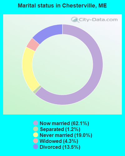
- Never married: 19.0%
- Now married: 62.1%
- Separated: 1.2%
- Widowed: 4.3%
- Divorced: 13.5%
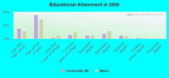
For population 25 years and over in Chesterville:
- High school or higher: 80.4%
- Bachelor's degree or higher: 19.0%
- Graduate or professional degree: 9.1%
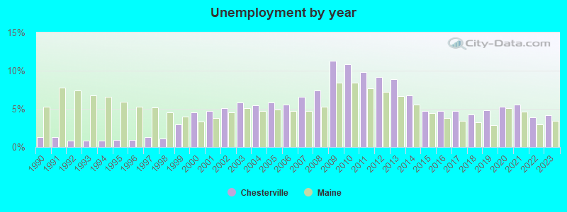
- Unemployed: 4.5%
- Mean travel time to work (commute): 31.3 minutes
| Here: | 12.0 |
| Maine average: | 11.2 |
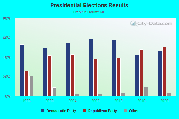
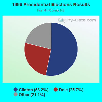
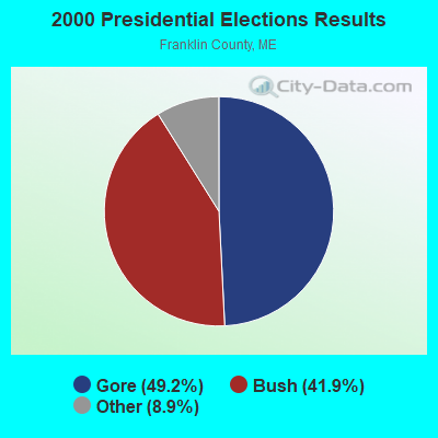
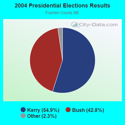
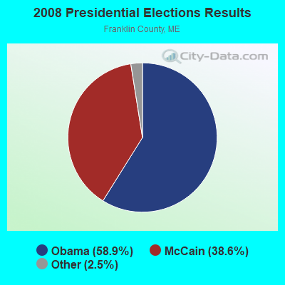
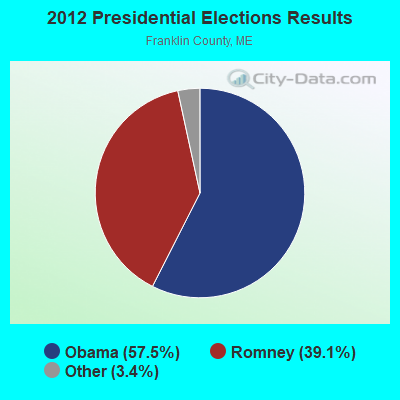

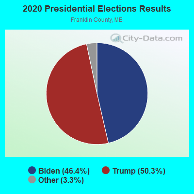
Graphs represent county-level data. Detailed 2008 Election Results
Religion statistics for Chesterville, ME (based on Franklin County data)
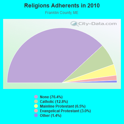
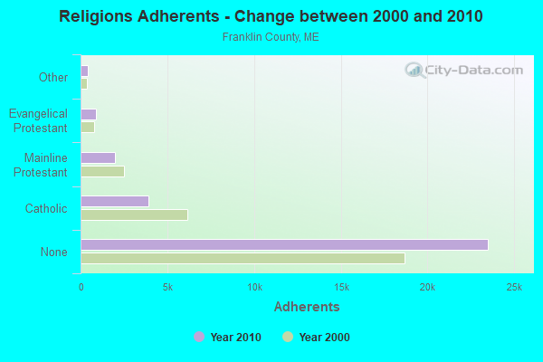
| Religion | Adherents | Congregations |
|---|---|---|
| Catholic | 3,936 | 5 |
| Mainline Protestant | 2,003 | 21 |
| Evangelical Protestant | 908 | 16 |
| Other | 427 | 2 |
| None | 23,494 | - |
Food Environment Statistics:
| This county: | 4.68 / 10,000 pop. |
| Maine: | 2.80 / 10,000 pop. |
| Franklin County: | 0.33 / 10,000 pop. |
| Maine: | 0.14 / 10,000 pop. |
| Here: | 3.01 / 10,000 pop. |
| Maine: | 2.20 / 10,000 pop. |
| This county: | 6.69 / 10,000 pop. |
| State: | 5.75 / 10,000 pop. |
| Franklin County: | 14.38 / 10,000 pop. |
| State: | 11.02 / 10,000 pop. |
| Franklin County: | 7.3% |
| Maine: | 8.2% |
| This county: | 24.4% |
| Maine: | 25.0% |
Strongest AM radio stations in Chesterville:
- WTME (780 AM; 10 kW; RUMFORD, ME; Owner: MOUNTAIN VALLEY BROADCASTING, INC.)
- WSKW (1160 AM; 10 kW; SKOWHEGAN, ME; Owner: MOUNTAIN WIRELESS, INCORPORATED)
- WFAU (1280 AM; 5 kW; GARDINER, ME; Owner: CAPSTAR TX LIMITED PARTNERSHIP)
- WRKO (680 AM; 50 kW; BOSTON, MA; Owner: ENTERCOM BOSTON LICENSE, LLC)
- WLAM (1470 AM; 5 kW; LEWISTON, ME; Owner: RADIO PARTNERS OF MAINE, L.P.)
- WMTW (870 AM; 10 kW; GORHAM, ME; Owner: RADIO PARTNERS OF MAINE, L.P.)
- WGAN (560 AM; 5 kW; PORTLAND, ME; Owner: SAGA COMMUNICATIONS OF NEW ENGLAND, LLC)
- WEEI (850 AM; 50 kW; BOSTON, MA; Owner: ENTERCOM BOSTON LICENSE, LLC)
- WBZ (1030 AM; 50 kW; BOSTON, MA; Owner: INFINITY BROADCASTING OPERATIONS, INC.)
- WCRN (830 AM; 50 kW; WORCESTER, MA; Owner: CARTER BROADCASTING CORPORATION)
- WZON (620 AM; 5 kW; BANGOR, ME; Owner: THE ZONE CORPORATION)
- WNNZ (640 AM; 50 kW; WESTFIELD, MA; Owner: CLEAR CHANNEL BROADCASTING LICENSES, INC.)
- WCHP (760 AM; 35 kW; CHAMPLAIN, NY; Owner: CHAMPLAIN RADIO, INC.)
Strongest FM radio stations in Chesterville:
- WTOS-FM (105.1 FM; SKOWHEGAN, ME; Owner: CAPSTAR TX LIMITED PARTNERSHIP)
- WKTJ-FM (99.3 FM; FARMINGTON, ME; Owner: FRANKLIN BROADCASTING CORPORATION)
- WLOB-FM (96.3 FM; RUMFORD, ME; Owner: ATLANTIC COAST RADIO, LLC)
- WTBM (100.7 FM; MEXICO, ME; Owner: MOUNTAIN VALLEY BROADCASTING, INC.)
- WPKQ (103.7 FM; NORTH CONWAY, NH; Owner: CITADEL BROADCASTING COMPANY)
- WHOM (94.9 FM; MT. WASHINGTON, NH; Owner: CITADEL BROADCASTING COMPANY)
- WHQO (107.9 FM; SKOWHEGAN, ME; Owner: MOUNTAIN WIRELESS, INC.)
- WWWA (95.3 FM; WINSLOW, ME; Owner: LIGHT OF LIFE MINISTRIES, INC.)
- WMEA (90.1 FM; PORTLAND, ME; Owner: MAINE PUBLIC BROADCASTING CORPORATION)
- WBLM (102.9 FM; PORTLAND, ME; Owner: CITADEL BROADCASTING COMPANY)
- WCYI (93.9 FM; LEWISTON, ME; Owner: CITADEL BROADCASTING COMPANY)
- WIGY (97.5 FM; MADISON, ME; Owner: CAPSTAR TX LIMITED PARTNERSHIP)
- WMME-FM (92.3 FM; AUGUSTA, ME; Owner: CITADEL BROADCASTING COMPANY)
- WABK-FM (104.3 FM; GARDINER, ME; Owner: CAPSTAR TX LIMITED PARTNERSHIP)
- WTHT (107.5 FM; LEWISTON, ME; Owner: RADIO PARTNERS OF MAINE, L.P.)
- WCTB (93.5 FM; FAIRFIELD, ME; Owner: MOUNTAIN WIRELESS, INC.)
- WKCG (101.3 FM; AUGUSTA, ME; Owner: CAPSTAR TX LIMITED PARTNERSHIP)
- WMEW (91.3 FM; WATERVILLE, ME; Owner: MAINE PUBLIC BROADCASTING CORPORATION)
- WEBB (98.5 FM; WATERVILLE, ME; Owner: CITADEL BROADCASTING COMPANY)
TV broadcast stations around Chesterville:
- W21BI (Channel 21; FARMINGTON, ME; Owner: TRINITY BROADCASTING NETWORK)
- WGME-TV (Channel 13; PORTLAND, ME; Owner: WGME LICENSEE, LLC)
- WPFO (Channel 23; WATERVILLE, ME; Owner: CMCG PORTLAND LICENSE LLC)
- WCBB (Channel 10; AUGUSTA, ME; Owner: MAINE PUBLIC BROADCASTING CORP.)
- WFYW-LP (Channel 69; FAIRFIELD/WATERVILLE, ME; Owner: THREE ANGELS BROADCASTING NETWORK, INC.)
- National Bridge Inventory (NBI) Statistics
- 5Number of bridges
- 52ft / 16.4mTotal length
- 12,822Total average daily traffic
- 460Total average daily truck traffic
- 14,171Total future (year 2036) average daily traffic
FCC Registered Antenna Towers:
8 (See the full list of FCC Registered Antenna Towers in Chesterville)FCC Registered Microwave Towers:
1- CHESTERVILLE, Chesterville Hill Road (Lat: 44.586833 Lon: -70.063194), Type: Gtower, Structure height: 76.2 m, Overall height: 77.7 m, Call Sign: WQQC433,
Assigned Frequencies: 6078.62 MHz, Grant Date: 09/20/2022, Expiration Date: 10/24/2032, Certifier: Steven T Campbell, Registrant: Wilkinson Barker Knauer, LLP, 1800 M Street Nw, Suite 800n, Washington, DC 20036, Phone: (202) 383-3420, Fax: (202) 783-5851, Email:
FCC Registered Amateur Radio Licenses:
2- Call Sign: KB1JXY, Licensee ID: L00681991, Grant Date: 05/08/2003, Expiration Date: 05/08/2013, Cancellation Date: 05/09/2015, Certifier: Steven L Mudie, Registrant: Steven L Mudie, 411 Chesterville Hill Rd, Chesterville, ME 04938
- Call Sign: KC1DAD, Previous Call Sign: KC1DGE, Licensee ID: L01920778, Grant Date: 05/24/2019, Expiration Date: 05/24/2029, Certifier: Dean P Robinson Mr, Registrant: Dean P Robinson, 652 Borough Road, Chesterville, ME 04938
FAA Registered Aircraft:
3- Aircraft: TAYLORCRAFT BC-65 (Category: Land, Seats: 2, Weight: Up to 12,499 Pounds, Speed: 78 mph), Engine: CONT MOTOR A&C65 SERIES (65 HP) (Reciprocating)
N-Number: 24046, N24046, N-24046, Serial Number: 1581, Airworthiness Date: 06/01/1956, Certificate Issue Date: 05/24/2018
Registrant (Individual): Henry E T Cooper, 543 Ridge Rd, Chesterville, ME 04938
Deregistered: Cancel Date: 10/27/2017 - Aircraft: CARTER ALTON S SUBER STAR (Category: Land, Weight: Up to 12,499 Pounds), Engine: SUBARU ALL MDLS A/B (400 HP) (Reciprocating)
N-Number: 499AC, N499AC, N-499AC, Serial Number: 002, Airworthiness Date: 09/11/2001, Certificate Issue Date: 10/23/2017
Registrant (Individual): Royce C Smith, 92 Vienna Rd, Chesterville, ME 04938 - Aircraft: CARTER ALTON S SUPER KITTEN (Category: Land, Seats: 2, Weight: Up to 12,499 Pounds), Engine: Reciprocating
N-Number: 599AC, N599AC, N-599AC, Serial Number: 001, Certificate Issue Date: 10/23/2017
Registrant (Individual): Royce C Smith, 92 Vienna Rd, Chesterville, ME 04938
Deregistered: Cancel Date: 05/15/2013
2002 - 2018 National Fire Incident Reporting System (NFIRS) incidents
- Fire incident types reported to NFIRS in Chesterville, ME
- 11963.3%Structure Fires
- 5227.7%Outside Fires
- 147.4%Mobile Property/Vehicle Fires
- 31.6%Other
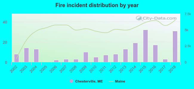 Based on the data from the years 2002 - 2018 the average number of fires per year is 11. The highest number of reported fire incidents - 32 took place in 2015, and the least - 0 in 2005. The data has a growing trend.
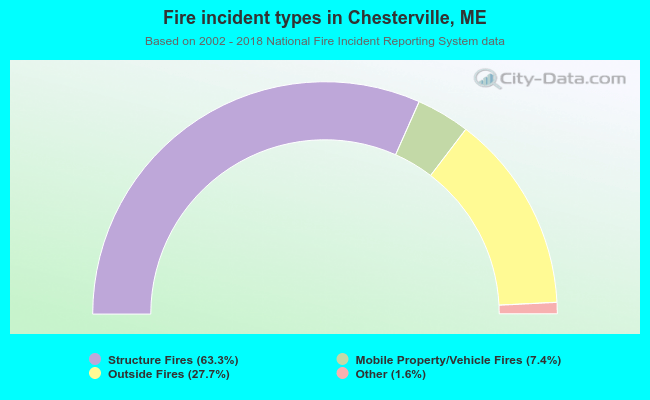 When looking into fire subcategories, the most reports belonged to: Structure Fires (63.3%), and Outside Fires (27.7%).
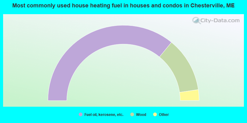
- 71.9%Fuel oil, kerosene, etc.
- 23.5%Wood
- 2.4%Bottled, tank, or LP gas
- 1.7%Electricity
- 0.5%Utility gas
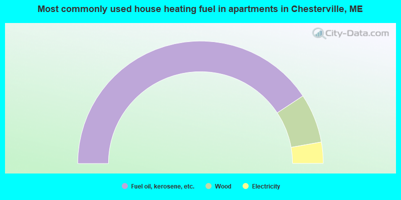
- 81.5%Fuel oil, kerosene, etc.
- 13.0%Wood
- 5.6%Electricity
Chesterville compared to Maine state average:
- Median house value below state average.
- Unemployed percentage below state average.
- Black race population percentage significantly below state average.
- Hispanic race population percentage significantly below state average.
- Foreign-born population percentage significantly below state average.
- Renting percentage significantly below state average.
- Length of stay since moving in significantly above state average.
- Number of rooms per house significantly below state average.
- House age significantly below state average.