East Kingston, New Hampshire
Submit your own pictures of this town and show them to the world
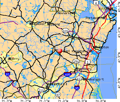
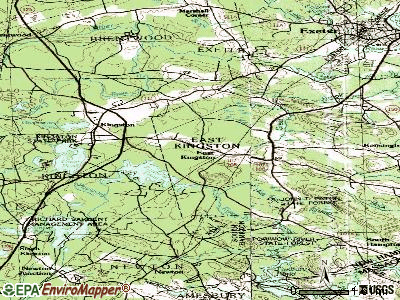
- OSM Map
- General Map
- Google Map
- MSN Map
Population change since 2000: +32.1%
| Males: 1,151 | |
| Females: 1,206 |
| Median resident age: | 44.6 years |
| New Hampshire median age: | 43.9 years |
Zip codes: 03827.
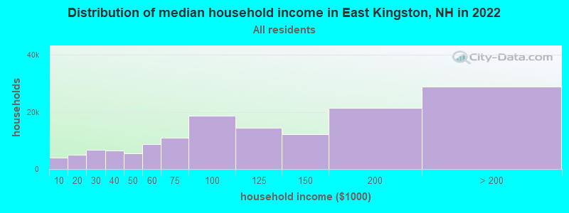
| East Kingston: | $120,463 |
| NH: | $89,992 |
Estimated per capita income in 2022: $63,316 (it was $28,844 in 2000)
East Kingston town income, earnings, and wages data
Estimated median house or condo value in 2022: $562,534 (it was $184,100 in 2000)
| East Kingston: | $562,534 |
| NH: | $384,700 |
Mean prices in 2022: all housing units: $614,227; detached houses: $665,470; townhouses or other attached units: $408,866; in 2-unit structures: $730,084; in 3-to-4-unit structures: over $1,000,000; in 5-or-more-unit structures: $329,099; mobile homes: $126,160
Detailed information about poverty and poor residents in East Kingston, NH


- 2,29497.3%White alone
- 220.9%Hispanic
- 170.7%Asian alone
- 170.7%Two or more races
- 30.1%Black alone
- 30.1%Other race alone
- 10.04%American Indian alone
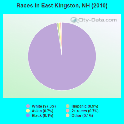
Races in East Kingston detailed stats: ancestries, foreign born residents, place of birth
According to our research of New Hampshire and other state lists, there were 6 registered sex offenders living in East Kingston, New Hampshire as of April 30, 2024.
The ratio of all residents to sex offenders in East Kingston is 393 to 1.
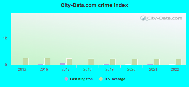
Type |
2013 |
2016 |
2017 |
2018 |
2019 |
2020 |
2021 |
2022 |
|---|---|---|---|---|---|---|---|---|
| Murders (per 100,000) | 0 (0.0) | 0 (0.0) | 0 (0.0) | 0 (0.0) | 0 (0.0) | 0 (0.0) | 0 (0.0) | 0 (0.0) |
| Rapes (per 100,000) | 0 (0.0) | 0 (0.0) | 1 (41.7) | 0 (0.0) | 0 (0.0) | 0 (0.0) | 1 (40.9) | 0 (0.0) |
| Robberies (per 100,000) | 0 (0.0) | 0 (0.0) | 0 (0.0) | 0 (0.0) | 0 (0.0) | 0 (0.0) | 0 (0.0) | 0 (0.0) |
| Assaults (per 100,000) | 0 (0.0) | 1 (41.4) | 1 (41.7) | 0 (0.0) | 1 (41.2) | 0 (0.0) | 0 (0.0) | 0 (0.0) |
| Burglaries (per 100,000) | 0 (0.0) | 1 (41.4) | 2 (83.5) | 1 (41.0) | 0 (0.0) | 0 (0.0) | 0 (0.0) | 0 (0.0) |
| Thefts (per 100,000) | 0 (0.0) | 6 (248.4) | 4 (166.9) | 1 (41.0) | 7 (288.1) | 4 (164.7) | 0 (0.0) | 4 (164.8) |
| Auto thefts (per 100,000) | 0 (0.0) | 0 (0.0) | 2 (83.5) | 0 (0.0) | 1 (41.2) | 1 (41.2) | 1 (40.9) | 0 (0.0) |
| Arson (per 100,000) | 0 (0.0) | 0 (0.0) | 0 (0.0) | 0 (0.0) | 0 (0.0) | 0 (0.0) | 0 (0.0) | 0 (0.0) |
| City-Data.com crime index | 0.0 | 21.1 | 60.9 | 4.5 | 23.0 | 9.9 | 36.0 | 6.6 |
The City-Data.com crime index weighs serious crimes and violent crimes more heavily. Higher means more crime, U.S. average is 246.1. It adjusts for the number of visitors and daily workers commuting into cities.
Crime rate in East Kingston detailed stats: murders, rapes, robberies, assaults, burglaries, thefts, arson
Full-time law enforcement employees in 2021, including police officers: 6 (5 officers - 5 male; 0 female).
| Officers per 1,000 residents here: | 2.04 |
| New Hampshire average: | 2.14 |
 Recent articles from our blog. Our writers, many of them Ph.D. graduates or candidates, create easy-to-read articles on a wide variety of topics.


 | Moving to southeast NH help!!! (48 replies) |
| Town recommendations for a job in Portsmouth (8 replies) |
| Looking at Southern NH...Where would you recommend searching? (15 replies) |
| Around 95 up to Portsmouth - Looking to buy a house in good school district 475k (11 replies) |
| Portsmouth vs Exeter for New Family (10 replies) |
| Relocating to NH Seacoast (26 replies) |
Latest news from East Kingston, NH collected exclusively by city-data.com from local newspapers, TV, and radio stations
Ancestries: Irish (25.3%), English (20.5%), French (11.5%), United States (11.2%), French Canadian (9.4%), Italian (8.3%).
Current Local Time: EST time zone
Incorporated in 1738
Elevation: 124 feet
Land area: 9.99 square miles.
Population density: 236 people per square mile (very low).
62 residents are foreign born (1.2% Asia, 1.0% Europe, 1.0% North America).
| This town: | 3.5% |
| New Hampshire: | 4.4% |
| East Kingston town: | 2.1% ($3,882) |
| New Hampshire: | 2.3% ($2,946) |
Nearest city with pop. 50,000+: Haverhill, MA  (11.5 miles , pop. 58,969).
Nearest city with pop. 200,000+: Boston, MA (42.6 miles , pop. 589,141).
Nearest city with pop. 1,000,000+: Bronx, NY (206.4 miles , pop. 1,332,650).
Nearest cities:
), ), ), )Latitude: 42.93 N, Longitude: 71.01 W
Area code commonly used in this area: 603

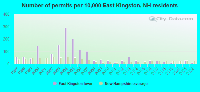
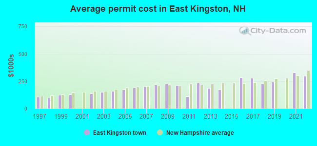
Single-family new house construction building permits:
- 2022: 2 buildings, average cost: $300,000
- 2021: 5 buildings, average cost: $330,000
- 2019: 2 buildings, average cost: $246,200
- 2018: 3 buildings, average cost: $226,700
- 2017: 4 buildings, average cost: $281,300
- 2016: 5 buildings, average cost: $286,000
- 2014: 5 buildings, average cost: $174,000
- 2013: 10 buildings, average cost: $184,900
- 2012: 5 buildings, average cost: $234,000
- 2011: 2 buildings, average cost: $110,000
- 2010: 5 buildings, average cost: $214,600
- 2009: 6 buildings, average cost: $225,300
- 2008: 5 buildings, average cost: $220,200
- 2007: 18 buildings, average cost: $200,300
- 2006: 20 buildings, average cost: $193,200
- 2005: 36 buildings, average cost: $173,600
- 2004: 52 buildings, average cost: $161,700
- 2003: 27 buildings, average cost: $152,300
- 2002: 14 buildings, average cost: $140,200
- 2000: 26 buildings, average cost: $131,100
- 1999: 8 buildings, average cost: $122,900
- 1998: 10 buildings, average cost: $99,000
- 1997: 10 buildings, average cost: $106,200
| Here: | 2.6% |
| New Hampshire: | 2.5% |
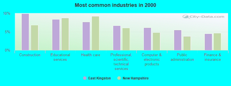
- Construction (9.9%)
- Educational services (8.4%)
- Health care (7.7%)
- Professional, scientific, technical services (6.7%)
- Computer & electronic products (6.2%)
- Public administration (5.5%)
- Finance & insurance (4.5%)
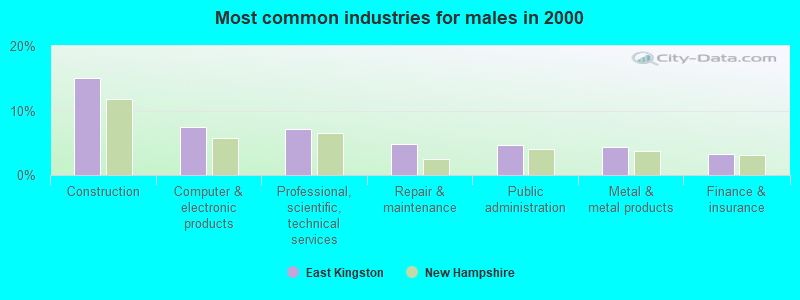
- Construction (15.0%)
- Computer & electronic products (7.5%)
- Professional, scientific, technical services (7.1%)
- Repair & maintenance (4.8%)
- Public administration (4.6%)
- Metal & metal products (4.4%)
- Finance & insurance (3.3%)
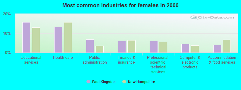
- Educational services (15.6%)
- Health care (13.3%)
- Public administration (6.8%)
- Finance & insurance (6.1%)
- Professional, scientific, technical services (6.1%)
- Computer & electronic products (4.4%)
- Accommodation & food services (4.0%)
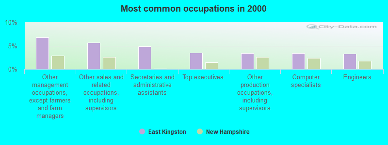
- Other management occupations, except farmers and farm managers (6.8%)
- Other sales and related occupations, including supervisors (5.6%)
- Secretaries and administrative assistants (4.8%)
- Top executives (3.5%)
- Other production occupations, including supervisors (3.4%)
- Computer specialists (3.4%)
- Engineers (3.3%)
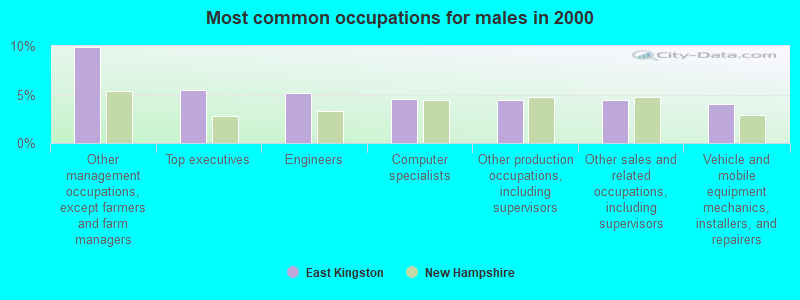
- Other management occupations, except farmers and farm managers (9.9%)
- Top executives (5.5%)
- Engineers (5.1%)
- Computer specialists (4.6%)
- Other production occupations, including supervisors (4.4%)
- Other sales and related occupations, including supervisors (4.4%)
- Vehicle and mobile equipment mechanics, installers, and repairers (4.0%)
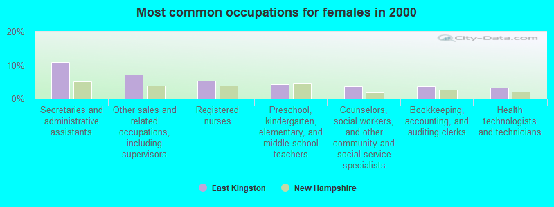
- Secretaries and administrative assistants (11.0%)
- Other sales and related occupations, including supervisors (7.2%)
- Registered nurses (5.4%)
- Preschool, kindergarten, elementary, and middle school teachers (4.4%)
- Counselors, social workers, and other community and social service specialists (3.7%)
- Bookkeeping, accounting, and auditing clerks (3.7%)
- Health technologists and technicians (3.3%)
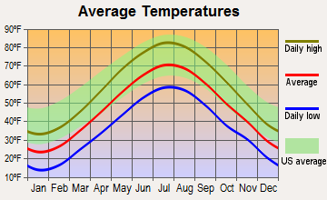
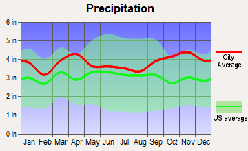
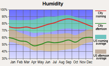
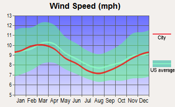
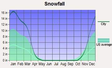
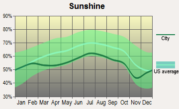
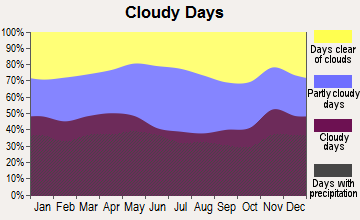
Average climate in East Kingston, New Hampshire
Based on data reported by over 4,000 weather stations
(lower is better)
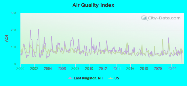
Air Quality Index (AQI) level in 2022 was 65.2. This is about average.
| City: | 65.2 |
| U.S.: | 72.6 |
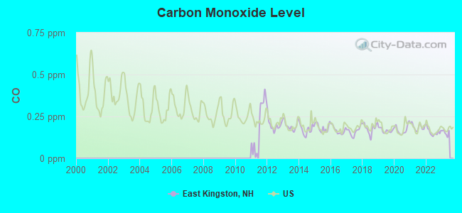
Carbon Monoxide (CO) [ppm] level in 2022 was 0.157. This is significantly better than average. Closest monitor was 15.9 miles away from the city center.
| City: | 0.157 |
| U.S.: | 0.251 |
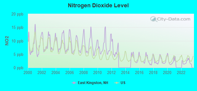
Nitrogen Dioxide (NO2) [ppb] level in 2022 was 2.05. This is significantly better than average. Closest monitor was 10.5 miles away from the city center.
| City: | 2.05 |
| U.S.: | 5.11 |
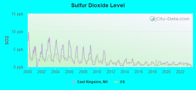
Sulfur Dioxide (SO2) [ppb] level in 2022 was 1.02. This is significantly better than average. Closest monitor was 10.5 miles away from the city center.
| City: | 1.02 |
| U.S.: | 1.51 |
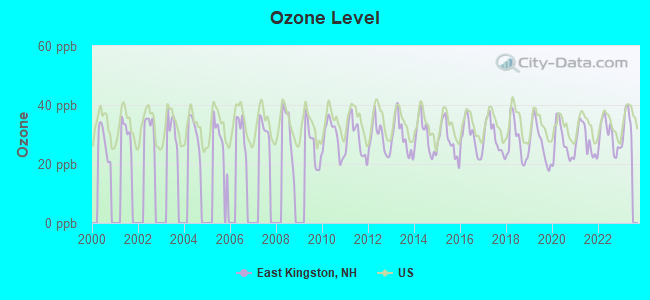
Ozone [ppb] level in 2022 was 29.6. This is about average. Closest monitor was 10.7 miles away from the city center.
| City: | 29.6 |
| U.S.: | 33.3 |
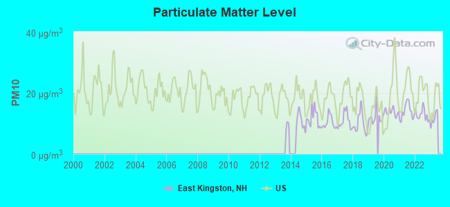
Particulate Matter (PM10) [µg/m3] level in 2022 was 12.8. This is significantly better than average. Closest monitor was 15.9 miles away from the city center.
| City: | 12.8 |
| U.S.: | 19.2 |
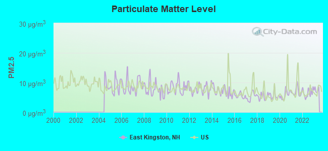
Particulate Matter (PM2.5) [µg/m3] level in 2022 was 6.52. This is better than average. Closest monitor was 12.3 miles away from the city center.
| City: | 6.52 |
| U.S.: | 8.11 |
Tornado activity:
East Kingston-area historical tornado activity is slightly above New Hampshire state average. It is 48% smaller than the overall U.S. average.
On 6/9/1953, a category F3 (max. wind speeds 158-206 mph) tornado 3.1 miles away from the East Kingston town center injured 5 people and caused between $5000 and $50,000 in damages.
On 9/29/1974, a category F3 tornado 23.8 miles away from the town center injured one person and caused between $50,000 and $500,000 in damages.
Earthquake activity:
East Kingston-area historical earthquake activity is significantly above New Hampshire state average. It is 73% smaller than the overall U.S. average.On 4/20/2002 at 10:50:47, a magnitude 5.3 (5.3 ML, Depth: 3.0 mi, Class: Moderate, Intensity: VI - VII) earthquake occurred 173.1 miles away from East Kingston center
On 1/19/1982 at 00:14:42, a magnitude 4.7 (4.5 MB, 4.7 MD, 4.5 LG, Class: Light, Intensity: IV - V) earthquake occurred 49.2 miles away from the city center
On 10/16/2012 at 23:12:25, a magnitude 4.7 (4.7 ML, Depth: 10.0 mi) earthquake occurred 49.1 miles away from East Kingston center
On 10/7/1983 at 10:18:46, a magnitude 5.3 (5.1 MB, 5.3 LG, 5.1 ML) earthquake occurred 181.6 miles away from East Kingston center
On 4/20/2002 at 10:50:47, a magnitude 5.2 (5.2 MB, 4.2 MS, 5.2 MW, 5.0 MW) earthquake occurred 172.9 miles away from East Kingston center
On 8/22/1992 at 12:20:32, a magnitude 4.8 (4.8 MB, 3.8 MS, 4.7 LG, Depth: 6.2 mi) earthquake occurred 267.2 miles away from East Kingston center
Magnitude types: regional Lg-wave magnitude (LG), body-wave magnitude (MB), duration magnitude (MD), local magnitude (ML), surface-wave magnitude (MS), moment magnitude (MW)
Natural disasters:
The number of natural disasters in Rockingham County (26) is a lot greater than the US average (15).Major Disasters (Presidential) Declared: 17
Emergencies Declared: 9
Causes of natural disasters: Storms: 12, Floods: 9, Winter Storms: 5, Hurricanes: 4, Snowstorms: 4, Snows: 2, Winds: 2, Blizzard: 1, Snowfall: 1, Tornado: 1 (Note: some incidents may be assigned to more than one category).
Hospitals and medical centers near East Kingston:
- RIVERWOODS AT EXETER (Nursing Home, about 3 miles away; EXETER, NH)
- ROCKINGHAM VNA AND HOSPICE (Home Health Center, about 5 miles away; EXETER, NH)
- EVENTIDE HOME INC (Nursing Home, about 5 miles away; EXETER, NH)
- EXETER HOSPITAL INC Acute Care Hospitals (about 6 miles away; EXETER, NH)
- EXETER HEALTHCARE (Nursing Home, about 6 miles away; EXETER, NH)
- FMC DIALYSIS SERVICES OF EXETER (Dialysis Facility, about 6 miles away; EXETER, NH)
- SEACOAST HOSPICE (Hospital, about 6 miles away; EXETER, NH)
Operable nuclear power plant near East Kingston:
- 9 miles: Seabrook in Seabrook, NH.
Colleges/universities with over 2000 students nearest to East Kingston:
- Northern Essex Community College (about 10 miles; Haverhill, MA; Full-time enrollment: 4,737)
- University of New Hampshire-Main Campus (about 15 miles; Durham, NH; FT enrollment: 15,243)
- Merrimack College (about 20 miles; North Andover, MA; FT enrollment: 2,734)
- North Shore Community College (about 24 miles; Danvers, MA; FT enrollment: 5,195)
- Mount Washington College (about 24 miles; Manchester, NH; FT enrollment: 2,187)
- Southern New Hampshire University (about 24 miles; Manchester, NH; FT enrollment: 16,552)
- University of Massachusetts-Lowell (about 26 miles; Lowell, MA; FT enrollment: 12,341)
Public elementary/middle school in East Kingston:
- EAST KINGSTON ELEMENTARY SCHOOL (Students: 177, Location: 5 ANDREWS LN., Grades: KG-5)
Points of interest:
Notable location: East Kingston Fire Department (A). Display/hide its location on the map
Church in East Kingston: East Kingston Methodist Church (A). Display/hide its location on the map
Cemeteries: East Kingston Cemetery (1), Old Cemetery (2), Hillside Cemetery (3). Display/hide their locations on the map
Reservoirs and swamps: Powwow Pond (A), Hog Hill Swamp (B). Display/hide their locations on the map
Streams, rivers, and creeks: York Brook (A), Brickyard Brook (B). Display/hide their locations on the map
Drinking water stations with addresses in East Kingston and their reported violations in the past:
BRANDYWINE (Population served: 72, Groundwater):Past health violations:Past monitoring violations:
- MCL, Monthly (TCR) - In SEP-2013, Contaminant: Coliform. Follow-up actions: St Public Notif requested (SEP-16-2013), St Violation/Reminder Notice (SEP-16-2013), St Public Notif received (NOV-08-2013), St Compliance achieved (MAR-31-2014)
- MCL, Monthly (TCR) - In JUN-2013, Contaminant: Coliform. Follow-up actions: St Public Notif requested (JUN-25-2013), St Violation/Reminder Notice (JUN-25-2013), St Public Notif received (JUL-22-2013), St Compliance achieved (MAR-31-2014)
- MCL, Monthly (TCR) - In FEB-2013, Contaminant: Coliform. Follow-up actions: St Public Notif requested (FEB-07-2013), St Violation/Reminder Notice (FEB-07-2013), St Public Notif received (MAR-05-2013), St Compliance achieved (MAR-31-2014)
- MCL, Monthly (TCR) - In JAN-2013, Contaminant: Coliform. Follow-up actions: St Public Notif requested (JAN-22-2013), St Violation/Reminder Notice (JAN-22-2013), St Public Notif received (FEB-25-2013), St Compliance achieved (MAR-31-2014)
- MCL, Monthly (TCR) - In DEC-2012, Contaminant: Coliform. Follow-up actions: St Public Notif requested (DEC-26-2012), St Violation/Reminder Notice (DEC-26-2012), St Public Notif received (JAN-17-2013), St Compliance achieved (MAR-31-2014)
- MCL, Monthly (TCR) - In NOV-2012, Contaminant: Coliform. Follow-up actions: St Public Notif requested (NOV-29-2012), St Violation/Reminder Notice (NOV-29-2012), St Formal NOV issued (DEC-20-2012), St Public Notif received (JAN-17-2013), St Compliance achieved (MAR-31-2014)
- 6 other older health violations
- Failure To Address Deficiency - In NOV-01-2013, Contaminant: GROUNDWATER RULE. Follow-up actions: St Public Notif requested (DEC-06-2013), St Violation/Reminder Notice (DEC-06-2013), St Public Notif received (JAN-09-2014), St Compliance achieved (MAY-09-2014)
| This town: | 2.7 people |
| New Hampshire: | 2.5 people |
| This town: | 81.1% |
| Whole state: | 66.3% |
| This town: | 6.4% |
| Whole state: | 8.3% |
Likely homosexual households (counted as self-reported same-sex unmarried-partner households)
- Lesbian couples: 0.3% of all households
- Gay men: 0.2% of all households
| This town: | 4.4% |
| Whole state: | 6.5% |
| This town: | 3.1% |
| Whole state: | 2.8% |
For population 15 years and over in East Kingston:
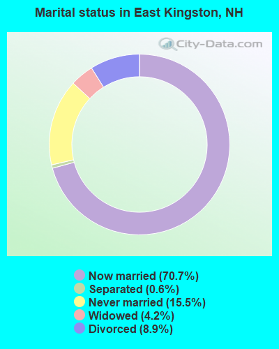
- Never married: 15.5%
- Now married: 70.7%
- Separated: 0.6%
- Widowed: 4.2%
- Divorced: 8.9%
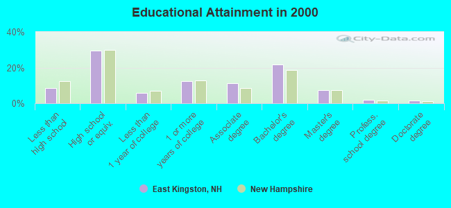
For population 25 years and over in East Kingston:
- High school or higher: 91.3%
- Bachelor's degree or higher: 32.3%
- Graduate or professional degree: 10.5%
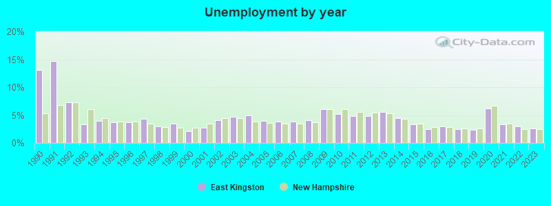
- Unemployed: 1.9%
- Mean travel time to work (commute): 31.6 minutes
| Here: | 10.0 |
| New Hampshire average: | 10.9 |


Graphs represent county-level data. Detailed 2008 Election Results
Religion statistics for East Kingston, NH (based on Rockingham County data)


| Religion | Adherents | Congregations |
|---|---|---|
| Catholic | 84,697 | 24 |
| Mainline Protestant | 19,072 | 78 |
| Evangelical Protestant | 7,456 | 61 |
| Other | 3,490 | 20 |
| Orthodox | 200 | 1 |
| None | 180,308 | - |
Food Environment Statistics:
| Rockingham County: | 1.59 / 10,000 pop. |
| State: | 2.14 / 10,000 pop. |
| Rockingham County: | 0.17 / 10,000 pop. |
| New Hampshire: | 0.15 / 10,000 pop. |
| This county: | 1.86 / 10,000 pop. |
| New Hampshire: | 1.78 / 10,000 pop. |
| This county: | 3.31 / 10,000 pop. |
| New Hampshire: | 4.02 / 10,000 pop. |
| This county: | 9.56 / 10,000 pop. |
| New Hampshire: | 9.70 / 10,000 pop. |
| Here: | 7.6% |
| New Hampshire: | 7.6% |
| Rockingham County: | 23.3% |
| New Hampshire: | 24.4% |
| Rockingham County: | 16.8% |
| New Hampshire: | 15.9% |
7.69% of this county's 2021 resident taxpayers lived in other counties in 2020 ($114,534 average adjusted gross income)
| Here: | 7.69% |
| New Hampshire average: | 7.66% |
0.01% of residents moved from foreign countries ($203 average AGI)
Rockingham County: 0.01% New Hampshire average: 0.01%
Top counties from which taxpayers relocated into this county between 2020 and 2021:
| from Essex County, MA | |
| from Hillsborough County, NH | |
| from Middlesex County, MA |
6.82% of this county's 2020 resident taxpayers moved to other counties in 2021 ($88,778 average adjusted gross income)
| Here: | 6.82% |
| New Hampshire average: | 6.80% |
0.01% of residents moved to foreign countries ($126 average AGI)
Rockingham County: 0.01% New Hampshire average: 0.01%
Top counties to which taxpayers relocated from this county between 2020 and 2021:
| to Hillsborough County, NH | |
| to Strafford County, NH | |
| to Essex County, MA |
Strongest AM radio stations in East Kingston:
- WGIP (1540 AM; 5 kW; EXETER, NH; Owner: CAPSTAR TX LIMITED PARTNERSHIP)
- WRKO (680 AM; 50 kW; BOSTON, MA; Owner: ENTERCOM BOSTON LICENSE, LLC)
- WDER (1320 AM; 10 kW; DERRY, NH; Owner: BLOUNT COMMUNICATIONS, INC. OF NH)
- WEEI (850 AM; 50 kW; BOSTON, MA; Owner: ENTERCOM BOSTON LICENSE, LLC)
- WBZ (1030 AM; 50 kW; BOSTON, MA; Owner: INFINITY BROADCASTING OPERATIONS, INC.)
- WWZN (1510 AM; 50 kW; BOSTON, MA; Owner: ROSE CITY RADIO CORPORATION)
- WGIN (930 AM; 10 kW; ROCHESTER, NH; Owner: CAPSTAR TX LIMITED PARTNERSHIP)
- WKOX (1200 AM; 50 kW; FRAMINGHAM, MA; Owner: CAPSTAR TX LIMITED PARTNERSHIP)
- WBIX (1060 AM; 40 kW; NATICK, MA; Owner: LANGER BROADCASTING CORPORATION)
- WCEC (1110 AM; daytime; 5 kW; SALEM, NH; Owner: COSTA-EAGLE RADIO VENTURES LTD PARTNERSHIP)
- WCRN (830 AM; 50 kW; WORCESTER, MA; Owner: CARTER BROADCASTING CORPORATION)
- WGIR (610 AM; 5 kW; MANCHESTER, NH; Owner: CAPSTAR TX LIMITED PARTNERSHIP)
- WTSN (1270 AM; 5 kW; DOVER, NH; Owner: GARRISON CITY BROADCASTING, INC.)
Strongest FM radio stations in East Kingston:
- WNEF (91.7 FM; NEWBURYPORT, MA; Owner: UNIVERSITY OF MASSACHUSETTS)
- WSAK (102.1 FM; HAMPTON, NH; Owner: CITADEL BROADCASTING COMPANY)
- WXRV (92.5 FM; HAVERHILL, MA; Owner: BEANPOT BROADCASTING CORP.)
- WERZ (107.1 FM; EXETER, NH; Owner: CAPSTAR TX LIMITED PARTNERSHIP)
- WHEB (100.3 FM; PORTSMOUTH, NH; Owner: CAPSTAR TX LIMITED PARTNERSHIP)
- WGIR-FM (101.1 FM; MANCHESTER, NH; Owner: CAPSTAR TX LIMITED PARTNERSHIP)
- WKLB-FM (99.5 FM; LOWELL, MA; Owner: GREATER BOSTON RADIO, INC.)
- WQLL (96.5 FM; BEDFORD, NH; Owner: SAGA COMMUNICATIONS OF NEW ENGLAND, LLC)
- WLMW (90.7 FM; MANCHESTER, NH; Owner: KNOWLEDGE FOR LIFE)
- WZID (95.7 FM; MANCHESTER, NH; Owner: SAGA COMMUNICATIONS OF NEW ENGLAND, LLC)
- W227AM (93.3 FM; ANDOVER, MA; Owner: GREATER BOSTON RADIO, INC.)
- WUBB (95.3 FM; YORK CENTER, ME; Owner: CAPSTAR TX LIMITED PARTNERSHIP)
- WOKQ (97.5 FM; DOVER, NH; Owner: CITADEL BROADCASTING COMPANY)
- WSCY (106.9 FM; MOULTONBOROUGH, NH; Owner: NORTHEAST COMMUNICATIONS CORPORATION)
- WFEX (92.1 FM; PETERBOROUGH, NH; Owner: FNX BROADCASTING OF NEW HAMPSHIRE LLC)
- WXKS-FM (107.9 FM; MEDFORD, MA; Owner: AMFM RADIO LICENSES, L.L.C.)
- WMJX (106.7 FM; BOSTON, MA; Owner: GREATER BOSTON RADIO, INC.)
- WHOB (106.3 FM; NASHUA, NH; Owner: TELE-MEDIA COMPANY OF NEW HAMPSHIRE, L.L.C.)
- WQSX (93.7 FM; LAWRENCE, MA; Owner: ENTERCOM BOSTON LICENSE, LLC)
- WBMX (98.5 FM; BOSTON, MA; Owner: INFINITY RADIO OPERATIONS INC.)
TV broadcast stations around East Kingston:
- WHDN-LP (Channel 26; BOSTON, MA; Owner: GUENTER MARKSTEINER)
- WFXZ-CA (Channel 24; BOSTON, MA; Owner: BOSTON BROADCASTING CORP.)
- WMEA-TV (Channel 26; BIDDEFORD, ME; Owner: MAINE PUBLIC BROADCASTING CORP.)
- WENH-TV (Channel 11; DURHAM, NH; Owner: UNIVERSITY OF NEW HAMPSHIRE)
- WCVB-TV (Channel 5; BOSTON, MA; Owner: WCVB HEARST-ARGYLE TV, INC.)
- WGBH-TV (Channel 2; BOSTON, MA; Owner: WGBH EDUCATIONAL FOUNDATION)
- WHDH-TV (Channel 7; BOSTON, MA; Owner: WHDH-TV)
- WMFP (Channel 62; LAWRENCE, MA; Owner: WSAH LICENSE, INC.)
- WSBK-TV (Channel 38; BOSTON, MA; Owner: VIACOM INC.)
- WBZ-TV (Channel 4; BOSTON, MA; Owner: VIACOM INC.)
- WGBX-TV (Channel 44; BOSTON, MA; Owner: WGBH EDUCATIONAL FOUNDATION)
- WLVI-TV (Channel 56; CAMBRIDGE, MA; Owner: WLVI, INC.)
- WUTF (Channel 66; MARLBOROUGH, MA; Owner: TELEFUTURA BOSTON LLC)
- WFXT (Channel 25; BOSTON, MA; Owner: FOX TELEVISION STATIONS INC.)
- WBPX (Channel 68; BOSTON, MA; Owner: PAXSON BOSTON-68 LICENSE, INC.)
- WNDS (Channel 50; DERRY, NH; Owner: CTV OF DERRY, INC)
- East Kingston, New Hampshire
- Fatal accident count8
- Vehicles involved in fatal accidents11
- Fatal accidents involving drunk persons:3
- Fatalities8
- Persons involved in fatal accidents19
- Pedestrians involved in fatal accidents0
- New Hampshire average
- Fatal accident count856
- Vehicles involved in fatal accidents1237
- Fatal accidents involving drunk persons262
- Fatalities930
- Persons involved in fatal accidents1929
- Pedestrians involved in fatal accidents114
- National Bridge Inventory (NBI) Statistics
- 3Number of bridges
- 20ft / 5.7mTotal length
- $9,426,000Total costs
- 4,177Total average daily traffic
- 166Total average daily truck traffic
- 6,181Total future (year 2042) average daily traffic
FCC Registered Broadcast Land Mobile Towers:
2- Fire Station Rt 108 & 107 (Lat: 42.922861 Lon: -71.008111), Call Sign: KRI737, Licensee ID: L00008549,
Assigned Frequencies: 31.9000 MHz, Grant Date: 08/08/2001, Expiration Date: 09/18/2011, Cancellation Date: 11/19/2003, Registrant: The State Of New Hampshire, Department Of Resources And Economic Development, 172 Pembroke Road, Concord, NH 03302-1856, Phone: (603) 271-2217, Fax: (603) 271-6488, Email:
- 5 Andrews Lane (Lat: 42.916167 Lon: -70.991306), Call Sign: WQPQ993,
Assigned Frequencies: 159.652 MHz, 160.072 MHz, Grant Date: 07/24/2012, Expiration Date: 07/24/2022, Cancellation Date: 09/24/2022, Certifier: Jim Eaves, Registrant: National License, 12591 Brompton Road, Carmel, IN 46033, Phone: (317) 564-8018, Email:
FCC Registered Amateur Radio Licenses:
14 (See the full list of FCC Registered Amateur Radio Licenses in East Kingston)FAA Registered Aircraft:
2- Aircraft: BOEING A75N1(PT17) (Category: Land, Seats: 2, Weight: Up to 12,499 Pounds, Speed: 93 mph), Engine: LYCOMING R680 (215 HP) (Reciprocating)
N-Number: 469RH, N469RH, N-469RH, Serial Number: 75-2252, Year manufactured: 1941, Airworthiness Date: 04/29/1976, Certificate Issue Date: 10/04/2016
Registrant (Individual): Thomas E Shaughnessy, 10 North Rd, East Kingston, NH 03827 - Aircraft: PIPER PA-28-180 (Category: Land, Seats: 4, Weight: Up to 12,499 Pounds, Speed: 107 mph), Engine: LYCOMING O&VO-360 SER (180 HP) (Reciprocating)
N-Number: 5159S, N5159S, N-5159S, Serial Number: 28-7105013, Year manufactured: 1970, Airworthiness Date: 09/29/1970, Certificate Issue Date: 08/13/2020
Registrant (Co-Owned): Justin B Lyons, 52 Willow Rd, East Kingston, NH 03827, Other Owners: Douglas M Mbatia, Jared T Debernardo
2003 - 2018 National Fire Incident Reporting System (NFIRS) incidents
- Fire incident types reported to NFIRS in East Kingston, NH
- 5845.0%Outside Fires
- 5038.8%Structure Fires
- 118.5%Other
- 107.8%Mobile Property/Vehicle Fires
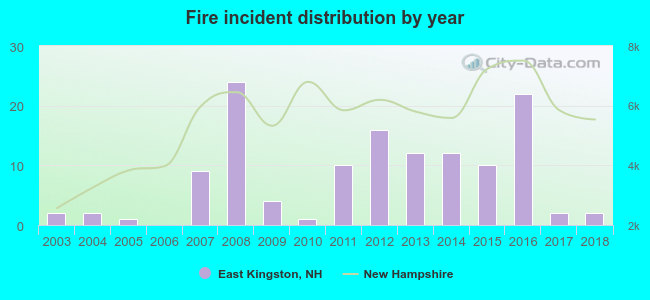 According to the data from the years 2003 - 2018 the average number of fires per year is 8. The highest number of fires - 24 took place in 2008, and the least - 0 in 2006. The data has a constant trend.
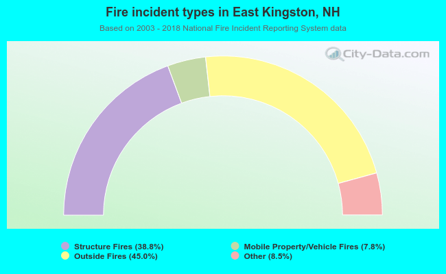 When looking into fire subcategories, the most reports belonged to: Outside Fires (45.0%), and Structure Fires (38.8%).
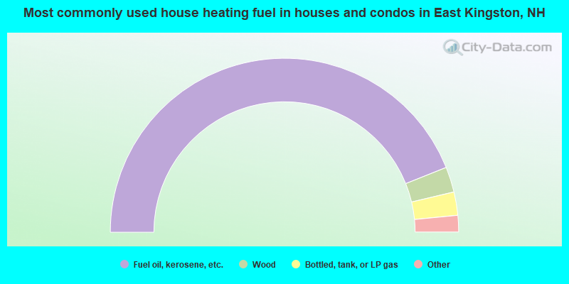
- 87.8%Fuel oil, kerosene, etc.
- 4.7%Wood
- 4.3%Bottled, tank, or LP gas
- 1.9%Electricity
- 1.2%Utility gas
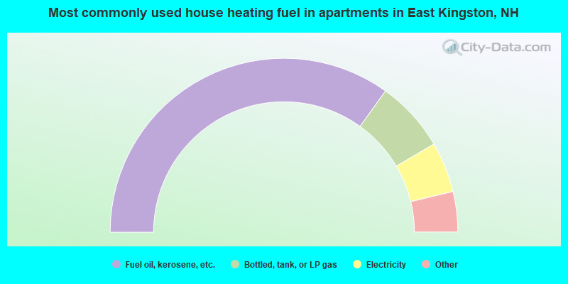
- 69.8%Fuel oil, kerosene, etc.
- 13.2%Bottled, tank, or LP gas
- 9.4%Electricity
- 3.8%Utility gas
- 3.8%Wood
East Kingston compared to New Hampshire state average:
- Unemployed percentage significantly below state average.
- Black race population percentage significantly below state average.
- Hispanic race population percentage significantly below state average.
- Foreign-born population percentage below state average.
- Renting percentage significantly below state average.
- Length of stay since moving in significantly above state average.
- Number of rooms per house significantly below state average.
- House age significantly below state average.

|
|
Total of 31 patent applications in 2008-2024.