Hampstead, New Hampshire
Submit your own pictures of this town and show them to the world
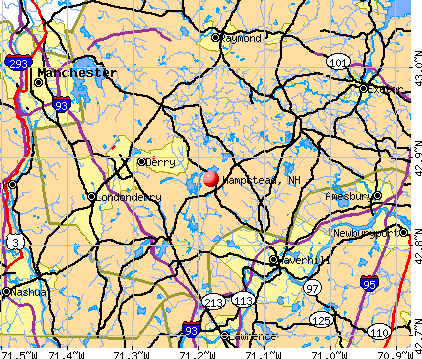
- OSM Map
- General Map
- Google Map
- MSN Map
Population change since 2000: +2.7%
 |
| Males: 4,220 | |
| Females: 4,303 |
| Median resident age: | 45.7 years |
| New Hampshire median age: | 43.9 years |
Zip codes: 03841.
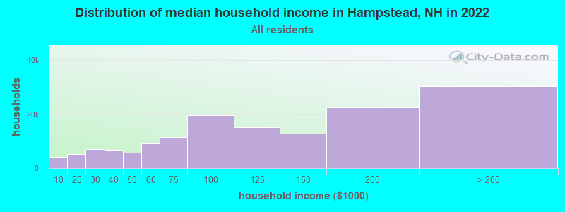
| Hampstead: | $126,626 |
| NH: | $89,992 |
Estimated per capita income in 2022: $64,086 (it was $29,195 in 2000)
Hampstead town income, earnings, and wages data
Estimated median house or condo value in 2022: $552,451 (it was $180,800 in 2000)
| Hampstead: | $552,451 |
| NH: | $384,700 |
Mean prices in 2022: all housing units: $614,227; detached houses: $665,470; townhouses or other attached units: $408,866; in 2-unit structures: $730,084; in 3-to-4-unit structures: over $1,000,000; in 5-or-more-unit structures: $329,099; mobile homes: $126,160
Detailed information about poverty and poor residents in Hampstead, NH


- 8,25896.9%White alone
- 841.0%Hispanic
- 800.9%Two or more races
- 680.8%Asian alone
- 200.2%Black alone
- 70.08%American Indian alone
- 50.06%Other race alone
- 10.01%Native Hawaiian and Other
Pacific Islander alone

Races in Hampstead detailed stats: ancestries, foreign born residents, place of birth
According to our research of New Hampshire and other state lists, there were 10 registered sex offenders living in Hampstead, New Hampshire as of April 30, 2024.
The ratio of all residents to sex offenders in Hampstead is 852 to 1.
The ratio of registered sex offenders to all residents in this city is lower than the state average.
Type |
2009 |
2010 |
2011 |
2012 |
2013 |
2014 |
2015 |
2016 |
2017 |
2018 |
2019 |
2020 |
2021 |
2022 |
|---|---|---|---|---|---|---|---|---|---|---|---|---|---|---|
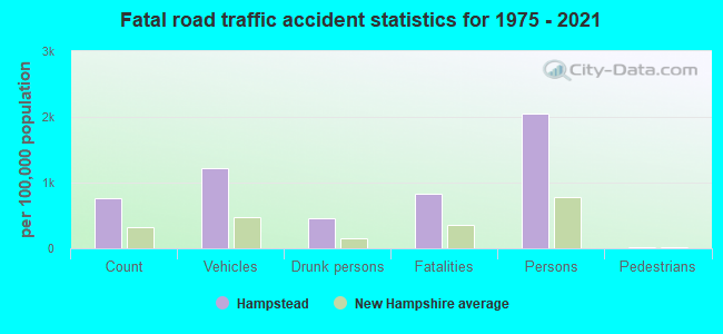
| Murders (per 100,000) | 0 (0.0) | 0 (0.0) | 0 (0.0) | 0 (0.0) | 0 (0.0) | 0 (0.0) | 0 (0.0) | 0 (0.0) | 0 (0.0) | 0 (0.0) | 0 (0.0) | 0 (0.0) | 0 (0.0) | 0 (0.0) |
| Rapes (per 100,000) | 1 (11.1) | 1 (11.7) | 0 (0.0) | 0 (0.0) | 1 (11.7) | 6 (69.9) | 1 (11.6) | 1 (11.6) | 2 (23.2) | 1 (11.5) | 3 (34.6) | 4 (46.2) | 3 (34.4) | 2 (22.1) |
| Robberies (per 100,000) | 1 (11.1) | 1 (11.7) | 3 (35.2) | 0 (0.0) | 0 (0.0) | 0 (0.0) | 0 (0.0) | 1 (11.6) | 0 (0.0) | 1 (11.5) | 0 (0.0) | 0 (0.0) | 0 (0.0) | 1 (11.0) |
| Assaults (per 100,000) | 1 (11.1) | 3 (35.2) | 4 (46.9) | 2 (23.3) | 5 (58.4) | 2 (23.3) | 1 (11.6) | 2 (23.3) | 8 (92.8) | 0 (0.0) | 4 (46.2) | 1 (11.6) | 4 (45.8) | 3 (33.1) |
| Burglaries (per 100,000) | 26 (288.1) | 26 (305.1) | 23 (269.5) | 35 (408.5) | 31 (361.8) | 10 (116.5) | 10 (116.2) | 10 (116.4) | 15 (173.9) | 5 (57.5) | 6 (69.3) | 3 (34.7) | 2 (22.9) | 1 (11.0) |
| Thefts (per 100,000) | 101 (1,119) | 63 (739.2) | 61 (714.8) | 72 (840.4) | 53 (618.6) | 33 (384.3) | 32 (371.8) | 47 (547.3) | 39 (452.2) | 38 (437.0) | 44 (508.0) | 33 (381.3) | 29 (332.1) | 22 (242.9) |
| Auto thefts (per 100,000) | 4 (44.3) | 3 (35.2) | 6 (70.3) | 12 (140.1) | 5 (58.4) | 7 (81.5) | 2 (23.2) | 2 (23.3) | 4 (46.4) | 4 (46.0) | 2 (23.1) | 4 (46.2) | 4 (45.8) | 4 (44.2) |
| Arson (per 100,000) | 0 (0.0) | 0 (0.0) | 0 (0.0) | 1 (11.7) | 0 (0.0) | 1 (11.6) | 0 (0.0) | 0 (0.0) | 0 (0.0) | 0 (0.0) | 0 (0.0) | 0 (0.0) | 0 (0.0) | 0 (0.0) |
| City-Data.com crime index | 82.9 | 73.7 | 73.0 | 78.1 | 75.7 | 90.6 | 36.5 | 49.4 | 71.1 | 37.8 | 64.0 | 60.7 | 55.2 | 41.6 |
The City-Data.com crime index weighs serious crimes and violent crimes more heavily. Higher means more crime, U.S. average is 246.1. It adjusts for the number of visitors and daily workers commuting into cities.
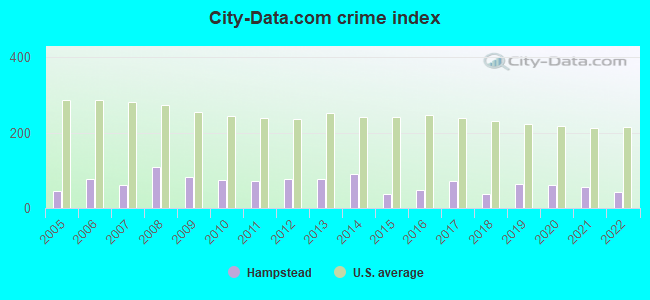
Crime rate in Hampstead detailed stats: murders, rapes, robberies, assaults, burglaries, thefts, arson
Full-time law enforcement employees in 2021, including police officers: 9 (9 officers - 9 male; 0 female).
| Officers per 1,000 residents here: | 1.03 |
| New Hampshire average: | 2.14 |
 Recent articles from our blog. Our writers, many of them Ph.D. graduates or candidates, create easy-to-read articles on a wide variety of topics.


 | Special Ed in Windham vs Hampstead (37 replies) |
| Picture Thread for NH (1997 replies) |
| Boston commuter looking into southern NH (42 replies) |
| Danville Hampstead area (0 replies) |
| In-Law apartment to Rent in Hampstead (1 reply) |
| Southern girl moving to NH (10 replies) |
Latest news from Hampstead, NH collected exclusively by city-data.com from local newspapers, TV, and radio stations
Ancestries: Irish (24.3%), Italian (15.7%), English (15.2%), French (11.4%), German (8.5%), French Canadian (8.0%).
Current Local Time: EST time zone
Incorporated in 1749
Elevation: 329 feet
Land area: 13.3 square miles.
Population density: 640 people per square mile (low).
243 residents are foreign born (1.6% Europe, 0.5% Asia, 0.4% Latin America, 0.4% North America).
| This town: | 2.9% |
| New Hampshire: | 4.4% |
| Hampstead town: | 2.0% ($3,625) |
| New Hampshire: | 2.3% ($2,946) |
Nearest city with pop. 50,000+: Haverhill, MA  (8.5 miles , pop. 58,969).
Nearest city with pop. 200,000+: Boston, MA (39.0 miles , pop. 589,141).
Nearest city with pop. 1,000,000+: Bronx, NY (197.9 miles , pop. 1,332,650).
Nearest cities:
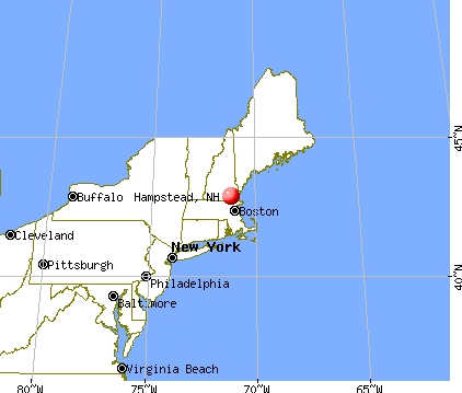
), Latitude: 42.88 N, Longitude: 71.17 W
Area code: 603

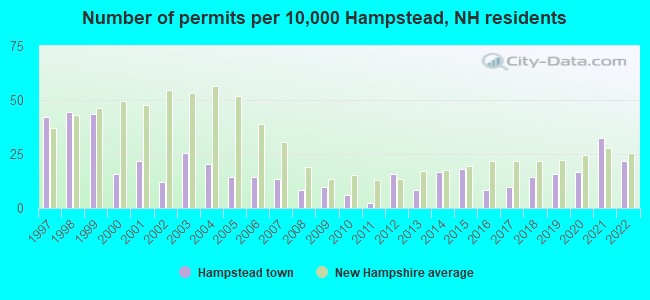
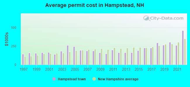
Single-family new house construction building permits:
- 2022: 18 buildings, average cost: $461,100
- 2021: 27 buildings, average cost: $261,900
- 2020: 14 buildings, average cost: $302,900
- 2019: 13 buildings, average cost: $265,600
- 2018: 12 buildings, average cost: $298,400
- 2017: 8 buildings, average cost: $227,500
- 2016: 7 buildings, average cost: $226,400
- 2015: 15 buildings, average cost: $189,900
- 2014: 14 buildings, average cost: $162,900
- 2013: 7 buildings, average cost: $164,300
- 2012: 13 buildings, average cost: $163,600
- 2011: 2 buildings, average cost: $200,000
- 2010: 5 buildings, average cost: $147,000
- 2009: 8 buildings, average cost: $164,600
- 2008: 7 buildings, average cost: $186,400
- 2007: 11 buildings, average cost: $187,700
- 2006: 12 buildings, average cost: $194,500
- 2005: 12 buildings, average cost: $246,700
- 2004: 17 buildings, average cost: $260,900
- 2003: 21 buildings, average cost: $183,700
- 2002: 10 buildings, average cost: $142,000
- 2001: 18 buildings, average cost: $169,100
- 2000: 13 buildings, average cost: $163,100
- 1999: 36 buildings, average cost: $158,200
- 1998: 37 buildings, average cost: $162,000
- 1997: 35 buildings, average cost: $146,100
| Here: | 2.9% |
| New Hampshire: | 2.5% |
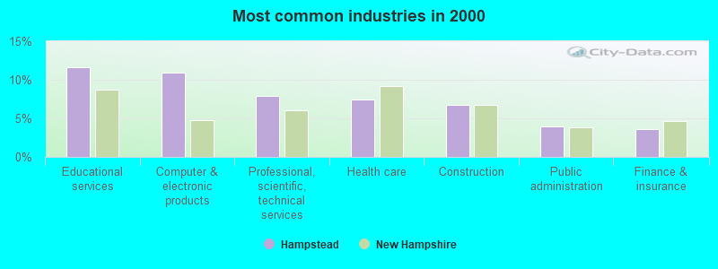
- Educational services (11.7%)
- Computer & electronic products (11.0%)
- Professional, scientific, technical services (8.0%)
- Health care (7.5%)
- Construction (6.7%)
- Public administration (3.9%)
- Finance & insurance (3.6%)
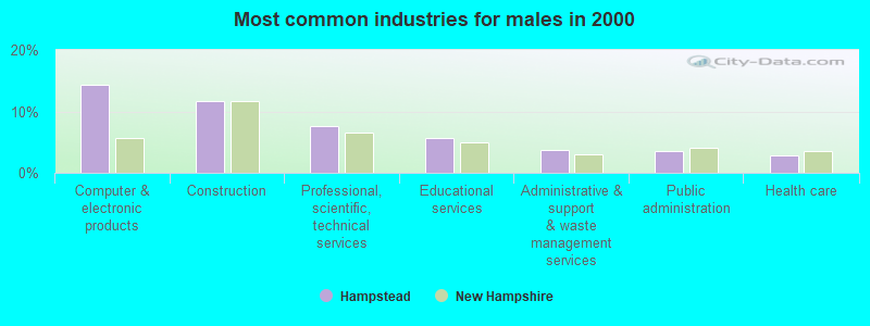
- Computer & electronic products (14.3%)
- Construction (11.8%)
- Professional, scientific, technical services (7.6%)
- Educational services (5.6%)
- Administrative & support & waste management services (3.6%)
- Public administration (3.5%)
- Health care (2.7%)
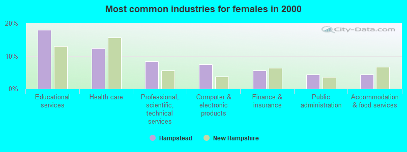
- Educational services (18.0%)
- Health care (12.5%)
- Professional, scientific, technical services (8.3%)
- Computer & electronic products (7.5%)
- Finance & insurance (5.5%)
- Public administration (4.4%)
- Accommodation & food services (4.4%)
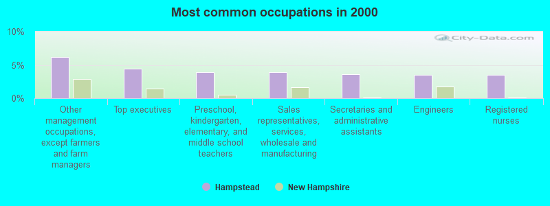
- Other management occupations, except farmers and farm managers (6.1%)
- Top executives (4.4%)
- Preschool, kindergarten, elementary, and middle school teachers (3.9%)
- Sales representatives, services, wholesale and manufacturing (3.9%)
- Secretaries and administrative assistants (3.6%)
- Engineers (3.5%)
- Registered nurses (3.5%)
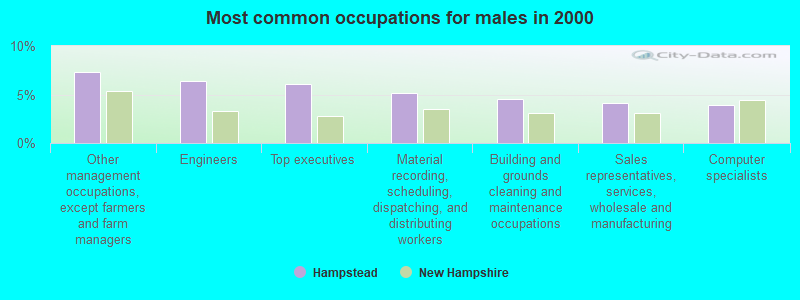
- Other management occupations, except farmers and farm managers (7.3%)
- Engineers (6.4%)
- Top executives (6.1%)
- Material recording, scheduling, dispatching, and distributing workers (5.1%)
- Building and grounds cleaning and maintenance occupations (4.5%)
- Sales representatives, services, wholesale and manufacturing (4.1%)
- Computer specialists (3.9%)
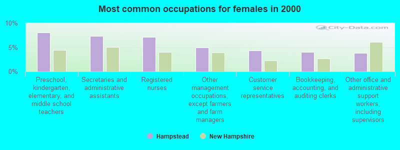
- Preschool, kindergarten, elementary, and middle school teachers (8.0%)
- Secretaries and administrative assistants (7.3%)
- Registered nurses (7.1%)
- Other management occupations, except farmers and farm managers (5.0%)
- Customer service representatives (4.3%)
- Bookkeeping, accounting, and auditing clerks (4.0%)
- Other office and administrative support workers, including supervisors (3.8%)
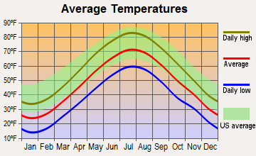
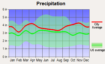
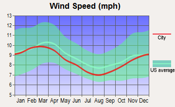
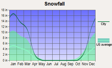
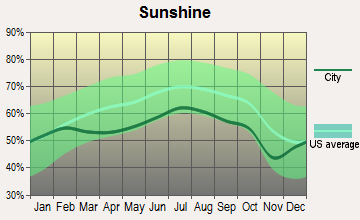
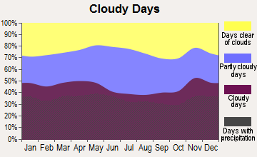
Average climate in Hampstead, New Hampshire
Based on data reported by over 4,000 weather stations

(lower is better)
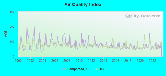
Air Quality Index (AQI) level in 2022 was 64.9. This is about average.
| City: | 64.9 |
| U.S.: | 72.6 |
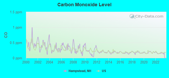
Carbon Monoxide (CO) [ppm] level in 2022 was 0.157. This is significantly better than average. Closest monitor was 10.6 miles away from the city center.
| City: | 0.157 |
| U.S.: | 0.251 |
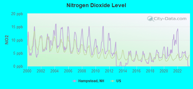
Nitrogen Dioxide (NO2) [ppb] level in 2022 was 5.21. This is about average. Closest monitor was 8.2 miles away from the city center.
| City: | 5.21 |
| U.S.: | 5.11 |
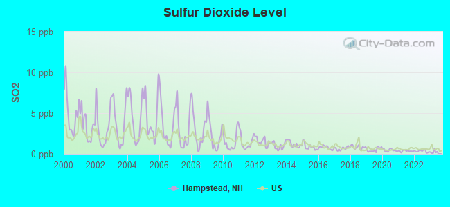
Sulfur Dioxide (SO2) [ppb] level in 2022 was 0.338. This is significantly better than average. Closest monitor was 8.7 miles away from the city center.
| City: | 0.338 |
| U.S.: | 1.515 |
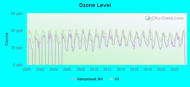
Ozone [ppb] level in 2022 was 28.7. This is about average. Closest monitor was 8.5 miles away from the city center.
| City: | 28.7 |
| U.S.: | 33.3 |
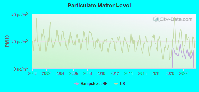
Particulate Matter (PM10) [µg/m3] level in 2022 was 10.6. This is significantly better than average. Closest monitor was 10.6 miles away from the city center.
| City: | 10.6 |
| U.S.: | 19.2 |
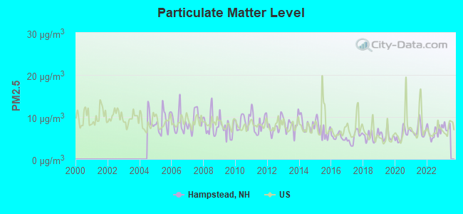
Particulate Matter (PM2.5) [µg/m3] level in 2022 was 6.40. This is better than average. Closest monitor was 8.5 miles away from the city center.
| City: | 6.40 |
| U.S.: | 8.11 |
Tornado activity:
Hampstead-area historical tornado activity is slightly above New Hampshire state average. It is 42% smaller than the overall U.S. average.
On 6/9/1953, a category F3 (max. wind speeds 158-206 mph) tornado 11.9 miles away from the Hampstead town center injured 5 people and caused between $5000 and $50,000 in damages.
On 9/29/1974, a category F3 tornado 18.2 miles away from the town center injured one person and caused between $50,000 and $500,000 in damages.
Earthquake activity:
Hampstead-area historical earthquake activity is significantly above New Hampshire state average. It is 72% smaller than the overall U.S. average.On 4/20/2002 at 10:50:47, a magnitude 5.3 (5.3 ML, Depth: 3.0 mi, Class: Moderate, Intensity: VI - VII) earthquake occurred 169.3 miles away from the city center
On 1/19/1982 at 00:14:42, a magnitude 4.7 (4.5 MB, 4.7 MD, 4.5 LG, Class: Light, Intensity: IV - V) earthquake occurred 47.8 miles away from the city center
On 10/7/1983 at 10:18:46, a magnitude 5.3 (5.1 MB, 5.3 LG, 5.1 ML) earthquake occurred 175.6 miles away from Hampstead center
On 10/16/2012 at 23:12:25, a magnitude 4.7 (4.7 ML, Depth: 10.0 mi) earthquake occurred 55.9 miles away from the city center
On 4/20/2002 at 10:50:47, a magnitude 5.2 (5.2 MB, 4.2 MS, 5.2 MW, 5.0 MW) earthquake occurred 168.9 miles away from the city center
On 8/22/1992 at 12:20:32, a magnitude 4.8 (4.8 MB, 3.8 MS, 4.7 LG, Depth: 6.2 mi) earthquake occurred 265.0 miles away from Hampstead center
Magnitude types: regional Lg-wave magnitude (LG), body-wave magnitude (MB), duration magnitude (MD), local magnitude (ML), surface-wave magnitude (MS), moment magnitude (MW)
Natural disasters:
The number of natural disasters in Rockingham County (26) is a lot greater than the US average (15).Major Disasters (Presidential) Declared: 17
Emergencies Declared: 9
Causes of natural disasters: Storms: 12, Floods: 9, Winter Storms: 5, Hurricanes: 4, Snowstorms: 4, Snows: 2, Winds: 2, Blizzard: 1, Snowfall: 1, Tornado: 1 (Note: some incidents may be assigned to more than one category).

Hospitals and medical centers in Hampstead:
Other hospitals and medical centers near Hampstead:
- LENOX NH INC (Nursing Home, about 6 miles away; HAVERHILL, MA)
- WARDE HEALTH CENTER (Nursing Home, about 7 miles away; WINDHAM, NH)
- AURORA SENIOR LIVING OF DERRY, LLC (Nursing Home, about 8 miles away; DERRY, NH)
- SALEMHAVEN (Nursing Home, about 8 miles away; SALEM, NH)
- KENOZA HILLCREST NURSING HOME (Nursing Home, about 8 miles away; HAVERHILL, MA)
- KENOZA MANOR CONV HOME (Nursing Home, about 8 miles away; HAVERHILL, MA)
- WINGATE AT HAVERHILL REHAB AND SKILLED NURSING RESID (Nursing Home, about 8 miles away; HAVERHILL, MA)
Heliports located in Hampstead:
Operable nuclear power plant near Hampstead:
- 17 miles: Seabrook in Seabrook, NH.
Colleges/universities with over 2000 students nearest to Hampstead:
- Northern Essex Community College (about 9 miles; Haverhill, MA; Full-time enrollment: 4,737)
- Merrimack College (about 16 miles; North Andover, MA; FT enrollment: 2,734)
- Mount Washington College (about 17 miles; Manchester, NH; FT enrollment: 2,187)
- University of Massachusetts-Lowell (about 18 miles; Lowell, MA; FT enrollment: 12,341)
- Southern New Hampshire University (about 18 miles; Manchester, NH; FT enrollment: 16,552)
- Saint Anselm College (about 19 miles; Manchester, NH; FT enrollment: 2,059)
- University of New Hampshire-Main Campus (about 22 miles; Durham, NH; FT enrollment: 15,243)
Public elementary/middle schools in Hampstead:
- HAMPSTEAD CENTRAL SCHOOL (Students: 536, Location: 21 EMERSON AVE., Grades: PK-4)
- HAMPSTEAD MIDDLE SCHOOL (Students: 521, Location: 28 SCHOOL ST., Grades: 5-8)
Private elementary/middle school in Hampstead:
- HAMPSTEAD ACADEMY (Students: 216, Location: 320 EAST RD, Grades: PK-8)
Points of interest:
Notable locations in Hampstead: Emersons Camping Area (A), Sunset Park Campground (B), Hampstead Fire Rescue East Hampstead Station (C), Hampstead Fire Rescue Central Station (D). Display/hide their locations on the map
Shopping Center: Shoppers Village Shopping Center (1). Display/hide its location on the map
Churches in Hampstead include: Saint Annes Church (A), Hampstead Congregational Church (B). Display/hide their locations on the map
Cemeteries: Soldiers Cemetery (1), Hadley Cemetery (2), Lakeview Cemetery (3), Old Cemetery (4), Pine Knoll Cemetery (5). Display/hide their locations on the map
Lakes and reservoirs: Hog Hill Pond (A), Wash Pond (B), Big Island Pond (C), Johnsons Pond (D), Wash Pond (E). Display/hide their locations on the map
Birthplace of: Ephraim Webster - Pioneer.
Drinking water stations with addresses in Hampstead and their reported violations in the past:
SANBORN SHORE ACRES (Population served: 370, Groundwater):Past monitoring violations:ROCKY RIVER RESORT (Population served: 100, Groundwater):
- 2 routine major monitoring violations
Past health violations:Past monitoring violations:
- MCL, Average - Between JAN-2011 and MAR-2011, Contaminant: Fluoride. Follow-up actions: St Public Notif requested (MAR-07-2011), St Violation/Reminder Notice (MAR-07-2011), St Public Notif received (MAY-03-2011), St Compliance achieved (OCT-20-2011)
- MCL, Average - Between OCT-2008 and DEC-2008, Contaminant: Fluoride. Follow-up actions: St Public Notif requested (JAN-23-2009), St Violation/Reminder Notice (JAN-23-2009), St Public Notif received (FEB-05-2009), St Compliance achieved (MAY-28-2009)
- MCL, Average - Between JUL-2008 and SEP-2008, Contaminant: Fluoride. Follow-up actions: St Public Notif requested (AUG-15-2008), St Violation/Reminder Notice (AUG-15-2008), St Public Notif received (SEP-16-2008), St Compliance achieved (MAY-28-2009)
- MCL, Average - Between APR-2008 and JUN-2008, Contaminant: Fluoride. Follow-up actions: St Public Notif requested (JUL-11-2008), St Violation/Reminder Notice (JUL-11-2008), St Public Notif received (AUG-05-2008), St Compliance achieved (MAY-28-2009)
- MCL, Average - Between JAN-2008 and MAR-2008, Contaminant: Fluoride. Follow-up actions: St Public Notif requested (MAR-17-2008), St Violation/Reminder Notice (MAR-17-2008), St Public Notif received (MAR-28-2008), St Compliance achieved (MAY-28-2009)
- MCL, Average - Between OCT-2007 and DEC-2007, Contaminant: Fluoride. Follow-up actions: St Public Notif requested (JAN-17-2008), St Violation/Reminder Notice (JAN-17-2008), St Public Notif received (JUL-03-2008), St Compliance achieved (MAY-28-2009)
- 9 other older health violations
- 25 regular monitoring violations
Drinking water stations with addresses in Hampstead that have no violations reported:
- SUNSET PARK CAMPGROUND (Population served: 125, Primary Water Source Type: Groundwater)
| This town: | 2.5 people |
| New Hampshire: | 2.5 people |
| This town: | 70.4% |
| Whole state: | 66.3% |
| This town: | 5.8% |
| Whole state: | 8.3% |
Likely homosexual households (counted as self-reported same-sex unmarried-partner households)
- Lesbian couples: 0.3% of all households
- Gay men: 0.3% of all households
| This town: | 3.8% |
| Whole state: | 6.5% |
| This town: | 1.7% |
| Whole state: | 2.8% |
3 people in other noninstitutional group quarters in 2000
Banks with branches in Hampstead (2011 data):
- People's United Bank: Hamstead-Villae Square Branch at 456 Route 111, branch established on 1892/01/01. Info updated 2012/02/16: Bank assets: $27,319.3 mil, Deposits: $20,835.4 mil, headquarters in Bridgeport, CT, positive income, Commercial Lending Specialization, 374 total offices
- Pentucket Bank: Hampstead Nh Branch at 201 Route 111, branch established on 2006/10/02. Info updated 2006/11/03: Bank assets: $642.8 mil, Deposits: $550.1 mil, headquarters in Haverhill, MA, positive income, Commercial Lending Specialization, 5 total offices
- TD Bank, National Association: Hampstead Branch at 220 Main Street, branch established on 1974/10/28. Info updated 2010/10/04: Bank assets: $188,912.6 mil, Deposits: $153,149.8 mil, headquarters in Wilmington, DE, positive income, 1314 total offices, Holding Company: Toronto-Dominion Bank, The
For population 15 years and over in Hampstead:
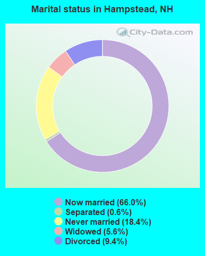
- Never married: 18.4%
- Now married: 66.0%
- Separated: 0.6%
- Widowed: 5.6%
- Divorced: 9.4%
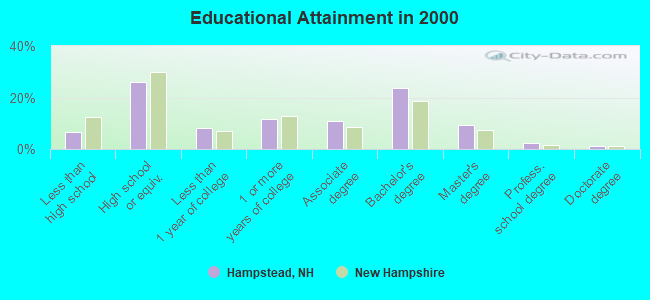
For population 25 years and over in Hampstead:
- High school or higher: 93.3%
- Bachelor's degree or higher: 36.3%
- Graduate or professional degree: 12.5%
- Unemployed: 2.3%
- Mean travel time to work (commute): 32.9 minutes
| Here: | 10.1 |
| New Hampshire average: | 10.9 |


Graphs represent county-level data. Detailed 2008 Election Results
Religion statistics for Hampstead, NH (based on Rockingham County data)


| Religion | Adherents | Congregations |
|---|---|---|
| Catholic | 84,697 | 24 |
| Mainline Protestant | 19,072 | 78 |
| Evangelical Protestant | 7,456 | 61 |
| Other | 3,490 | 20 |
| Orthodox | 200 | 1 |
| None | 180,308 | - |
Food Environment Statistics:
| This county: | 1.59 / 10,000 pop. |
| New Hampshire: | 2.14 / 10,000 pop. |
| This county: | 0.17 / 10,000 pop. |
| New Hampshire: | 0.15 / 10,000 pop. |
| Rockingham County: | 1.86 / 10,000 pop. |
| New Hampshire: | 1.78 / 10,000 pop. |
| This county: | 3.31 / 10,000 pop. |
| New Hampshire: | 4.02 / 10,000 pop. |
| Rockingham County: | 9.56 / 10,000 pop. |
| New Hampshire: | 9.70 / 10,000 pop. |
| This county: | 7.6% |
| New Hampshire: | 7.6% |
| This county: | 23.3% |
| New Hampshire: | 24.4% |
| Rockingham County: | 16.8% |
| New Hampshire: | 15.9% |
7.69% of this county's 2021 resident taxpayers lived in other counties in 2020 ($114,534 average adjusted gross income)
| Here: | 7.69% |
| New Hampshire average: | 7.66% |
0.01% of residents moved from foreign countries ($203 average AGI)
Rockingham County: 0.01% New Hampshire average: 0.01%
Top counties from which taxpayers relocated into this county between 2020 and 2021:
| from Essex County, MA | |
| from Hillsborough County, NH | |
| from Middlesex County, MA |
6.82% of this county's 2020 resident taxpayers moved to other counties in 2021 ($88,778 average adjusted gross income)
| Here: | 6.82% |
| New Hampshire average: | 6.80% |
0.01% of residents moved to foreign countries ($126 average AGI)
Rockingham County: 0.01% New Hampshire average: 0.01%
Top counties to which taxpayers relocated from this county between 2020 and 2021:
| to Hillsborough County, NH | |
| to Strafford County, NH | |
| to Essex County, MA |
Businesses in Hampstead, NH
- FedEx: 1
- U-Haul: 1
- UPS: 2
Strongest AM radio stations in Hampstead:
- WDER (1320 AM; 10 kW; DERRY, NH; Owner: BLOUNT COMMUNICATIONS, INC. OF NH)
- WRKO (680 AM; 50 kW; BOSTON, MA; Owner: ENTERCOM BOSTON LICENSE, LLC)
- WCEC (1110 AM; daytime; 5 kW; SALEM, NH; Owner: COSTA-EAGLE RADIO VENTURES LTD PARTNERSHIP)
- WEEI (850 AM; 50 kW; BOSTON, MA; Owner: ENTERCOM BOSTON LICENSE, LLC)
- WWZN (1510 AM; 50 kW; BOSTON, MA; Owner: ROSE CITY RADIO CORPORATION)
- WBZ (1030 AM; 50 kW; BOSTON, MA; Owner: INFINITY BROADCASTING OPERATIONS, INC.)
- WGIR (610 AM; 5 kW; MANCHESTER, NH; Owner: CAPSTAR TX LIMITED PARTNERSHIP)
- WKOX (1200 AM; 50 kW; FRAMINGHAM, MA; Owner: CAPSTAR TX LIMITED PARTNERSHIP)
- WBIX (1060 AM; 40 kW; NATICK, MA; Owner: LANGER BROADCASTING CORPORATION)
- WCRN (830 AM; 50 kW; WORCESTER, MA; Owner: CARTER BROADCASTING CORPORATION)
- WGIP (1540 AM; 5 kW; EXETER, NH; Owner: CAPSTAR TX LIMITED PARTNERSHIP)
- WFEA (1370 AM; 5 kW; MANCHESTER, NH; Owner: SAGA COMMUNICATIONS OF NEW ENGLAND, LLC)
- WCAP (980 AM; 5 kW; LOWELL, MA; Owner: NORTHEAST RADIO, INC.)
Strongest FM radio stations in Hampstead:
- WXRV (92.5 FM; HAVERHILL, MA; Owner: BEANPOT BROADCASTING CORP.)
- WKLB-FM (99.5 FM; LOWELL, MA; Owner: GREATER BOSTON RADIO, INC.)
- WGIR-FM (101.1 FM; MANCHESTER, NH; Owner: CAPSTAR TX LIMITED PARTNERSHIP)
- WQLL (96.5 FM; BEDFORD, NH; Owner: SAGA COMMUNICATIONS OF NEW ENGLAND, LLC)
- WLMW (90.7 FM; MANCHESTER, NH; Owner: KNOWLEDGE FOR LIFE)
- WZID (95.7 FM; MANCHESTER, NH; Owner: SAGA COMMUNICATIONS OF NEW ENGLAND, LLC)
- WHOB (106.3 FM; NASHUA, NH; Owner: TELE-MEDIA COMPANY OF NEW HAMPSHIRE, L.L.C.)
- W227AM (93.3 FM; ANDOVER, MA; Owner: GREATER BOSTON RADIO, INC.)
- WNEF (91.7 FM; NEWBURYPORT, MA; Owner: UNIVERSITY OF MASSACHUSETTS)
- WFEX (92.1 FM; PETERBOROUGH, NH; Owner: FNX BROADCASTING OF NEW HAMPSHIRE LLC)
- WSAK (102.1 FM; HAMPTON, NH; Owner: CITADEL BROADCASTING COMPANY)
- WXKS-FM (107.9 FM; MEDFORD, MA; Owner: AMFM RADIO LICENSES, L.L.C.)
- WMJX (106.7 FM; BOSTON, MA; Owner: GREATER BOSTON RADIO, INC.)
- WBMX (98.5 FM; BOSTON, MA; Owner: INFINITY RADIO OPERATIONS INC.)
- WSCY (106.9 FM; MOULTONBOROUGH, NH; Owner: NORTHEAST COMMUNICATIONS CORPORATION)
- WJMN (94.5 FM; BOSTON, MA; Owner: AMFM RADIO LICENSES, L.L.C.)
- WCRB (102.5 FM; WALTHAM, MA; Owner: CHARLES RIVER BROADCASTING WCRB LICE)
- WTKK (96.9 FM; BOSTON, MA; Owner: GREATER BOSTON RADIO, INC.)
- WROR-FM (105.7 FM; FRAMINGHAM, MA; Owner: GREATER BOSTON RADIO, INC.)
- WBOS (92.9 FM; BROOKLINE, MA; Owner: GREATER BOSTON RADIO, INC.)
TV broadcast stations around Hampstead:
- WFXZ-CA (Channel 24; BOSTON, MA; Owner: BOSTON BROADCASTING CORP.)
- WHDN-LP (Channel 26; BOSTON, MA; Owner: GUENTER MARKSTEINER)
- WNDS (Channel 50; DERRY, NH; Owner: CTV OF DERRY, INC)
- WCVB-TV (Channel 5; BOSTON, MA; Owner: WCVB HEARST-ARGYLE TV, INC.)
- WGBH-TV (Channel 2; BOSTON, MA; Owner: WGBH EDUCATIONAL FOUNDATION)
- WMEA-TV (Channel 26; BIDDEFORD, ME; Owner: MAINE PUBLIC BROADCASTING CORP.)
- WHDH-TV (Channel 7; BOSTON, MA; Owner: WHDH-TV)
- WENH-TV (Channel 11; DURHAM, NH; Owner: UNIVERSITY OF NEW HAMPSHIRE)
- WMFP (Channel 62; LAWRENCE, MA; Owner: WSAH LICENSE, INC.)
- WUTF (Channel 66; MARLBOROUGH, MA; Owner: TELEFUTURA BOSTON LLC)
- WBZ-TV (Channel 4; BOSTON, MA; Owner: VIACOM INC.)
- WGBX-TV (Channel 44; BOSTON, MA; Owner: WGBH EDUCATIONAL FOUNDATION)
- WSBK-TV (Channel 38; BOSTON, MA; Owner: VIACOM INC.)
- WLVI-TV (Channel 56; CAMBRIDGE, MA; Owner: WLVI, INC.)
- WFXT (Channel 25; BOSTON, MA; Owner: FOX TELEVISION STATIONS INC.)
- WBPX (Channel 68; BOSTON, MA; Owner: PAXSON BOSTON-68 LICENSE, INC.)
- WUNI (Channel 27; WORCESTER, MA; Owner: ENTRAVISION HOLDINGS, LLC)
- WTMU-LP (Channel 32; BOSTON, MA; Owner: ZGS BOSTON, INC.)
- WCEA-LP (Channel 58; BOSTON, MA; Owner: CHANNEL 19 TV CORPORATION)
- W40BO (Channel 40; BOSTON, MA; Owner: PAXSON COMMUNICATIONS LPTV, INC.)
- WPXG (Channel 21; CONCORD, NH; Owner: PAXSON BOSTON-68 LICENSE, INC.)
- W29AT (Channel 29; MANCHESTER, NH; Owner: CENTER BROADCASTING CORP. OF NEW HAMPSHIRE)
FCC Registered Broadcast Land Mobile Towers:
7- Fire Dept Main St (Lat: 42.842028 Lon: -71.179778), Call Sign: KRI740, Licensee ID: L00008549,
Assigned Frequencies: 31.9000 MHz, Grant Date: 08/08/2001, Expiration Date: 09/18/2011, Cancellation Date: 11/19/2003, Registrant: The State Of New Hampshire, Department Of Resources And Economic Development, 172 Pembroke Road, Concord, NH 03302-1856, Phone: (603) 271-2217, Fax: (603) 271-6488, Email:
- Emerson Ave (Lat: 42.883972 Lon: -71.161444), Call Sign: KGW733, Licensee ID: L00002006,
Assigned Frequencies: 155.460 MHz, Grant Date: 02/13/2003, Expiration Date: 02/11/2013, Cancellation Date: 04/13/2013, Registrant: County Of Rockingham, 101 North Rd, Bremtwppd, NH 03833, Phone: (603) 679-2225
- Hampstead Police Dept Emerson Ave (Lat: 42.883972 Lon: -71.161444), Call Sign: KVI696,
Assigned Frequencies: 155.475 MHz, 156.090 MHz, Grant Date: 04/27/2022, Expiration Date: 07/09/2032, Registrant: Nh Dept. Of Safety/Emergency Services And Communications, 33 Hazen Dr (Mailing), Concord, NH 03305, Phone: (603) 528-7541, Fax: (603) 271-6629, Email:
- Granite Village Pump Station (Lat: 42.900889 Lon: -71.175361), Type: Building, Structure height: 6.1 m, Overall height: 7.6 m, Call Sign: WQFK756,
Assigned Frequencies: 465.012 MHz, 451.412 MHz, Grant Date: 05/28/2016, Expiration Date: 08/07/2026, Certifier: Robert Levine, Registrant: Tcs Communications Corp, 85 Lafayette Rd, Salisbury, MA 01952, Phone: (978) 465-7932, Fax: (978) 462-8980, Email:
- Lat: 42.874528 Lon: -71.180056, Call Sign: WQKU585,
Assigned Frequencies: 467.212 MHz, Grant Date: 09/17/2009, Expiration Date: 09/17/2019, Cancellation Date: 11/23/2019, Certifier: Michael Hall, Registrant: Innovation Wireless, 11869 Teale Street, Culver City, CA 90230, Phone: (888) 559-5565, Fax: (310) 482-3480, Email:
- HAMPSTEAD MS, Lat: 42.880083 Lon: -71.177389, Call Sign: WRJB676,
Assigned Frequencies: 467.212 MHz, Grant Date: 08/01/2020, Expiration Date: 08/01/2030, Certifier: Jeffrey M Mackey, Registrant: Innovation Wireless, 11869 Teale St, Culver City, CA 90230, Phone: (888) 559-5565, Fax: (310) 482-3480, Email:
- Lat: 42.874528 Lon: -71.180056, Call Sign: WRTN668,
Assigned Frequencies: 467.212 MHz, Grant Date: 07/08/2022, Expiration Date: 07/08/2032, Certifier: Michael Hall, Registrant: Innovation Wireless, 11869 Teale Street, Culver City, CA 90230, Phone: (888) 559-5565, Fax: (310) 482-3480, Email:
FCC Registered Amateur Radio Licenses:
38 (See the full list of FCC Registered Amateur Radio Licenses in Hampstead)FAA Registered Aircraft:
5- Aircraft: TL ULTRALIGHT SRO STINGSPORT (Category: Land, Seats: 2, Weight: Up to 12,499 Pounds), Engine: ROTAX 912ULS SERIES (100 HP) (4 Cycle)
N-Number: 464N, N464N, N-464N, Serial Number: TLUSA149, Year manufactured: 2006, Airworthiness Date: 01/02/2007, Certificate Issue Date: 09/05/2012
Registrant (Individual): Richard A Jones, Po Box 589, Hampstead, NH 03841 - Aircraft: PIPER PA-22-108 (Category: Land, Seats: 2, Weight: Up to 12,499 Pounds, Speed: 94 mph), Engine: LYCOMING 0-235 SERIES (115 HP) (Reciprocating)
N-Number: 5819Z, N5819Z, N-5819Z, Serial Number: 22-9676, Year manufactured: 1963, Airworthiness Date: 08/06/1963, Certificate Issue Date: 03/31/2004
Registrant (Co-Owned): Anthony J Leocha, 60 Holiday Ln, Hampstead, NH 03841, Other Owners: Phyllis Leocha - Aircraft: CESSNA 150M (Category: Land, Seats: 2, Weight: Up to 12,499 Pounds, Speed: 81 mph), Engine: CONT MOTOR 0-200 SERIES (100 HP) (4 Cycle)
N-Number: 66755, N66755, N-66755, Serial Number: 15076253, Year manufactured: 1974, Airworthiness Date: 10/22/1974, Certificate Issue Date: 01/19/1982
Registrant (Individual): A Edward Jr Fischer, 62 Spring Brook Drive, Hampstead, NH 03841 - Aircraft: PIPER PA-20 (Category: Land, Seats: 4, Weight: Up to 12,499 Pounds, Speed: 94 mph), Engine: LYCOMING 0-290 SERIES (140 HP) (Reciprocating)
N-Number: 6923K, N6923K, N-6923K, Serial Number: 20-26, Year manufactured: 1950, Airworthiness Date: 08/21/1964, Certificate Issue Date: 06/22/2007
Registrant (Co-Owned): Anthony J Leocha, 60 Holiday Ln, Hampstead, NH 03841, Other Owners: Phyllis Leocha - Aircraft: PIPER PA-22-150 (Category: Land, Seats: 4, Weight: Up to 12,499 Pounds, Speed: 94 mph), Engine: LYCOMING 0-320 SERIES (180 HP) (Reciprocating)
N-Number: 7551D, N7551D, N-7551D, Serial Number: 22-5282, Year manufactured: 1957, Airworthiness Date: 05/24/1957, Certificate Issue Date: 09/22/1987
Registrant (Co-Owned): Anthony J Leocha, 18 Stage Road, Hampstead, NH 03841, Other Owners: Phyllis Leocha
2002 - 2018 National Fire Incident Reporting System (NFIRS) incidents
- Fire incident types reported to NFIRS in Hampstead, NH
- 16256.2%Structure Fires
- 8529.5%Outside Fires
- 2910.1%Mobile Property/Vehicle Fires
- 124.2%Other
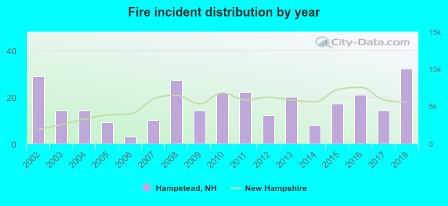 Based on the data from the years 2002 - 2018 the average number of fires per year is 17. The highest number of fire incidents - 32 took place in 2018, and the least - 3 in 2006. The data has a rising trend.
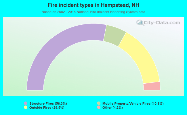 When looking into fire subcategories, the most reports belonged to: Structure Fires (56.2%), and Outside Fires (29.5%).
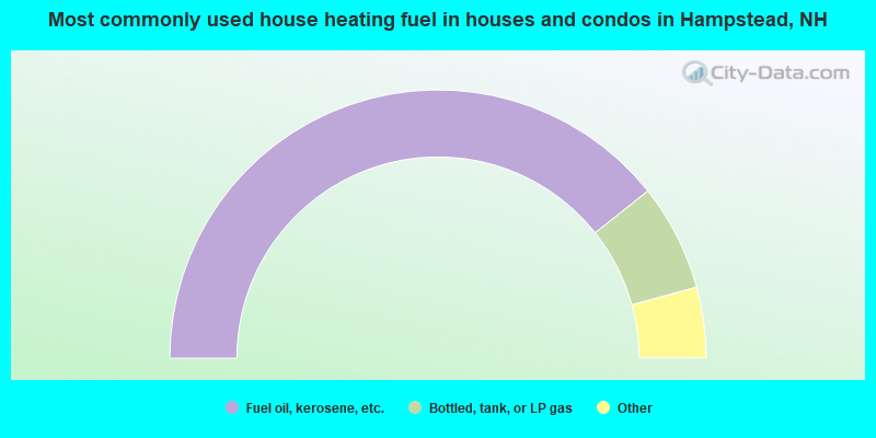
- 78.6%Fuel oil, kerosene, etc.
- 12.9%Bottled, tank, or LP gas
- 2.9%Electricity
- 1.9%Other fuel
- 1.7%Utility gas
- 1.3%Wood
- 0.4%No fuel used
- 0.3%Coal or coke
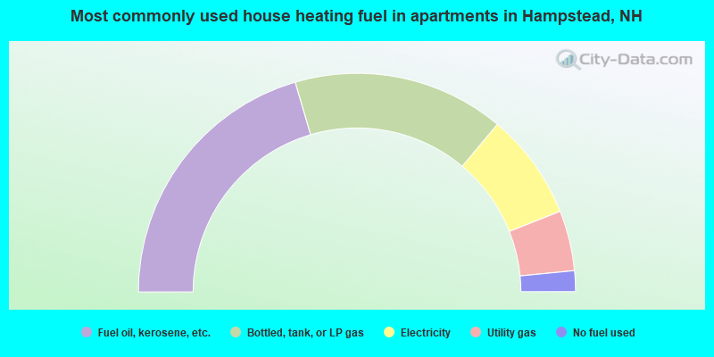
- 40.9%Fuel oil, kerosene, etc.
- 31.3%Bottled, tank, or LP gas
- 15.8%Electricity
- 8.9%Utility gas
- 3.1%No fuel used
Hampstead compared to New Hampshire state average:
- Unemployed percentage significantly below state average.
- Black race population percentage significantly below state average.
- Hispanic race population percentage significantly below state average.
- Foreign-born population percentage below state average.
- Renting percentage below state average.
- Length of stay since moving in significantly above state average.
- Number of rooms per house significantly below state average.
- House age significantly below state average.
Hampstead on our top lists:
- #10 on the list of "Top 101 cities with largest percentage of females in industries: data processing, libraries, and other information services (population 5,000+)"
- #12 on the list of "Top 101 cities with largest percentage of males in industries: computer and electronic products (population 5,000+)"
- #12 on the list of "Top 101 cities with largest percentage of females in industries: petroleum and petroleum products merchant wholesalers (population 5,000+)"
- #13 on the list of "Top 101 cities with largest percentage of males in occupations: financial managers (population 5,000+)"
- #20 on the list of "Top 101 cities with largest percentage of females in industries: computer and electronic products (population 5,000+)"
- #24 on the list of "Top 101 cities with largest percentage of males in industries: recyclable material merchant wholesalers (population 5,000+)"
- #25 on the list of "Top 101 cities with largest percentage of females in occupations: supervisors of transportation and material moving workers (population 5,000+)"
- #27 on the list of "Top 101 cities with largest percentage of females in occupations: top executives (population 5,000+)"
- #31 on the list of "Top 101 cities with largest percentage of males in industries: motor vehicles, parts and supplies merchant wholesalers (population 5,000+)"
- #36 on the list of "Top 101 cities with largest percentage of males in industries: u. s. postal service (population 5,000+)"
- #50 on the list of "Top 101 cities with the largest city-data.com crime index increase from 2002 to 2012 (population 5,000+)"
- #54 on the list of "Top 101 cities with largest percentage of females in occupations: life and physical scientists (population 5,000+)"
- #59 on the list of "Top 101 cities with largest percentage of males in occupations: media and communication equipment workers (population 5,000+)"
- #64 on the list of "Top 101 cities with largest percentage of females in occupations: registered nurses (population 5,000+)"
- #67 on the list of "Top 101 cities with largest percentage of males in industries: lumber and other construction materials merchant wholesalers (population 5,000+)"
- #68 on the list of "Top 101 cities with largest percentage of males in industries: hardware, plumbing and heating equipment, and supplies merchant wholesalers (population 5,000+)"
- #70 on the list of "Top 101 cities with largest percentage of males in industries: radio, tv, and computer stores (population 5,000+)"
- #88 on the list of "Top 101 cities with largest percentage of females in industries: fuel dealers (population 5,000+)"
- #91 on the list of "Top 101 cities with largest percentage of males in industries: vending machine operators (population 5,000+)"
- #9 on the list of "Top 101 counties with the largest decrease in the number of births per 1000 residents 2000-2006 to 2007-2013 (pop 50,000+)"
- #14 on the list of "Top 101 counties with the best general health status score of residents (1-5), 3 years of data"
- #16 on the list of "Top 101 counties with the lowest number of births per 1000 residents 2007-2013"
- #22 on the list of "Top 101 counties with the lowest Particulate Matter (PM10) Annual air pollution readings in 2012 (µg/m3)"
- #36 on the list of "Top 101 counties with the highest percentage of residents that visited a dentist within the past year"

|
|
Total of 182 patent applications in 2008-2024.