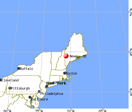
Newry, Maine
Submit your own pictures of this town and show them to the world
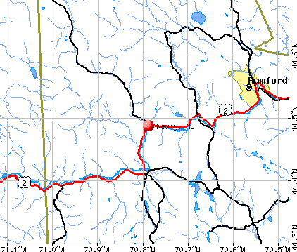
- OSM Map
- General Map
- Google Map
- MSN Map
Population change since 2000: -4.4%
 |
| Males: 175 | |
| Females: 154 |
| Median resident age: | 49.9 years |
| Maine median age: | 43.0 years |
Zip codes: 04261.
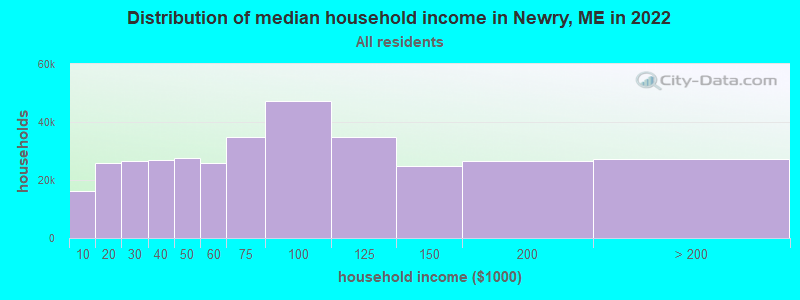
| Newry: | $70,651 |
| ME: | $69,543 |
Estimated per capita income in 2022: $41,547 (it was $21,982 in 2000)
Newry town income, earnings, and wages data
Estimated median house or condo value in 2022: $311,811 (it was $119,300 in 2000)
| Newry: | $311,811 |
| ME: | $290,600 |
Mean prices in 2022: all housing units: $258,607; detached houses: $254,021; townhouses or other attached units: $393,466; in 2-unit structures: $184,786; in 3-to-4-unit structures: $229,715; in 5-or-more-unit structures: $205,553; mobile homes: $333,480; occupied boats, rvs, vans, etc.: $32,243
Detailed information about poverty and poor residents in Newry, ME


- 31997.0%White alone
- 41.2%American Indian alone
- 30.9%Two or more races
- 30.9%Hispanic
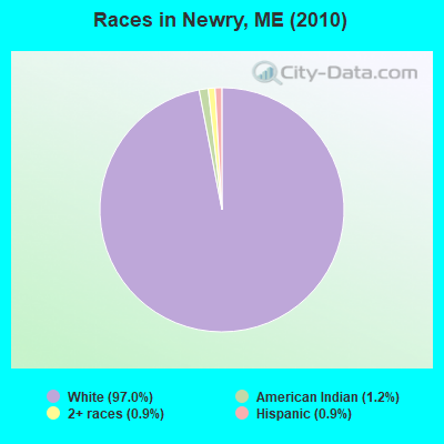
Races in Newry detailed stats: ancestries, foreign born residents, place of birth
 Recent articles from our blog. Our writers, many of them Ph.D. graduates or candidates, create easy-to-read articles on a wide variety of topics.


 | Small town Maine retirement (47 replies) |
| Oxford County Questions (2 replies) |
| Looking for Suggestions Please (10 replies) |
| Wights camps and cottages in Newry (4 replies) |
| I'm 1/2 way set to move to The Pinetree State... (10 replies) |
| Cost of Land in Aroostook County (6 replies) |
Latest news from Newry, ME collected exclusively by city-data.com from local newspapers, TV, and radio stations
Ancestries: English (27.9%), United States (19.5%), Irish (11.6%), French (11.0%), German (7.0%), Italian (6.1%).
Current Local Time: EST time zone
Incorporated on 06/15/1805
Elevation: 642 feet
Land area: 61.4 square miles.
Population density: 5.4 people per square mile (very low).
7 residents are foreign born (0.9% Europe, 0.6% Asia, 0.6% Oceania).
| This town: | 2.0% |
| Maine: | 2.9% |
| Newry town: | 0.8% ($908) |
| Maine: | 1.5% ($1,417) |
Nearest city with pop. 50,000+: Portland, ME  (64.4 miles , pop. 64,249).
Nearest city with pop. 200,000+: Boston, MA (151.4 miles , pop. 589,141).
Nearest city with pop. 1,000,000+: Bronx, NY (296.3 miles , pop. 1,332,650).
Nearest cities:
), ), Latitude: 44.50 N, Longitude: 70.84 W
Area code commonly used in this area: 207

Newry tourist attractions:
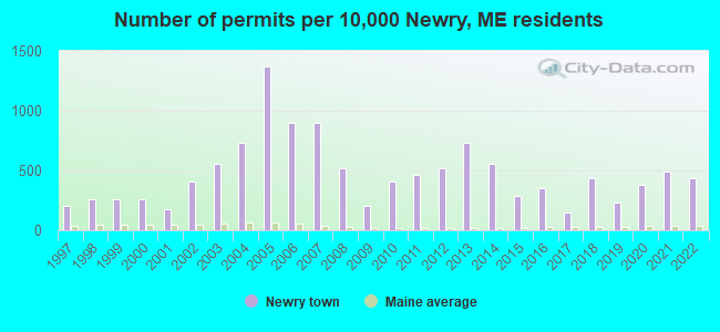
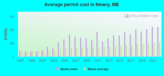
Single-family new house construction building permits:
- 2022: 15 buildings, average cost: $556,500
- 2021: 17 buildings, average cost: $562,600
- 2020: 13 buildings, average cost: $517,200
- 2019: 8 buildings, average cost: $466,000
- 2018: 15 buildings, average cost: $518,900
- 2017: 5 buildings, average cost: $423,000
- 2016: 12 buildings, average cost: $465,400
- 2015: 10 buildings, average cost: $400,100
- 2014: 19 buildings, average cost: $404,200
- 2013: 25 buildings, average cost: $344,800
- 2012: 18 buildings, average cost: $287,900
- 2011: 16 buildings, average cost: $471,100
- 2010: 14 buildings, average cost: $316,900
- 2009: 7 buildings, average cost: $340,700
- 2008: 18 buildings, average cost: $360,400
- 2007: 31 buildings, average cost: $379,400
- 2006: 31 buildings, average cost: $421,000
- 2005: 47 buildings, average cost: $335,100
- 2004: 25 buildings, average cost: $270,000
- 2003: 19 buildings, average cost: $173,700
- 2002: 14 buildings, average cost: $189,300
- 2001: 6 buildings, average cost: $121,400
- 2000: 9 buildings, average cost: $101,700
- 1999: 9 buildings, average cost: $101,700
- 1998: 9 buildings, average cost: $101,700
- 1997: 7 buildings, average cost: $114,300
| Here: | 2.2% |
| Maine: | 3.4% |
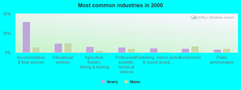
- Accommodation & food services (31.9%)
- Educational services (9.5%)
- Agriculture, forestry, fishing & hunting (6.2%)
- Professional, scientific, technical services (5.7%)
- Publishing, motion picture & sound recording industries (4.8%)
- Construction (4.3%)
- Public administration (3.3%)
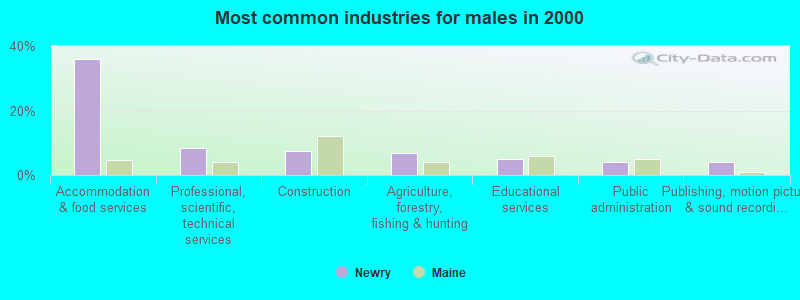
- Accommodation & food services (35.8%)
- Professional, scientific, technical services (8.3%)
- Construction (7.5%)
- Agriculture, forestry, fishing & hunting (6.7%)
- Educational services (5.0%)
- Public administration (4.2%)
- Publishing, motion picture & sound recording industries (4.2%)
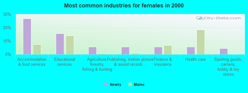
- Accommodation & food services (26.7%)
- Educational services (15.6%)
- Agriculture, forestry, fishing & hunting (5.6%)
- Publishing, motion picture & sound recording industries (5.6%)
- Finance & insurance (5.6%)
- Health care (5.6%)
- Sporting goods, camera, hobby & toy stores (4.4%)
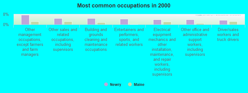
- Other management occupations, except farmers and farm managers (7.6%)
- Other sales and related occupations, including supervisors (4.8%)
- Building and grounds cleaning and maintenance occupations (4.8%)
- Entertainers and performers, sports, and related workers (4.3%)
- Electrical equipment mechanics and other installation, maintenance, and repair workers, including supervisors (3.8%)
- Other office and administrative support workers, including supervisors (3.8%)
- Driver/sales workers and truck drivers (3.3%)
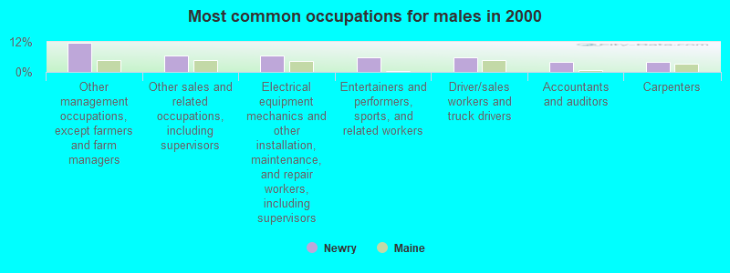
- Other management occupations, except farmers and farm managers (11.7%)
- Other sales and related occupations, including supervisors (6.7%)
- Electrical equipment mechanics and other installation, maintenance, and repair workers, including supervisors (6.7%)
- Entertainers and performers, sports, and related workers (5.8%)
- Driver/sales workers and truck drivers (5.8%)
- Accountants and auditors (4.2%)
- Carpenters (4.2%)
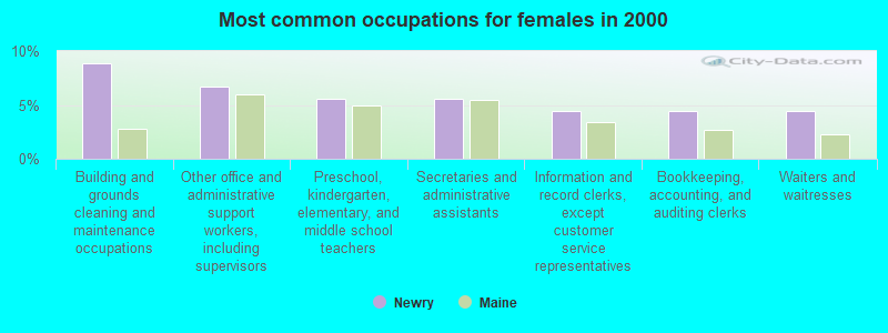
- Building and grounds cleaning and maintenance occupations (8.9%)
- Other office and administrative support workers, including supervisors (6.7%)
- Preschool, kindergarten, elementary, and middle school teachers (5.6%)
- Secretaries and administrative assistants (5.6%)
- Information and record clerks, except customer service representatives (4.4%)
- Bookkeeping, accounting, and auditing clerks (4.4%)
- Waiters and waitresses (4.4%)
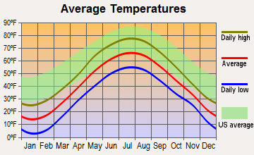
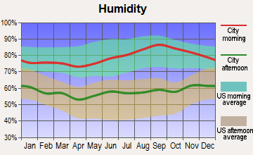
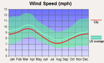
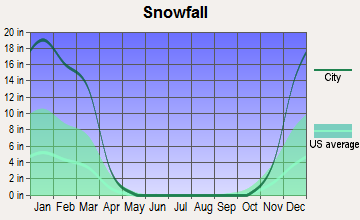
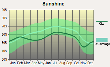
Average climate in Newry, Maine
Based on data reported by over 4,000 weather stations
(lower is better)
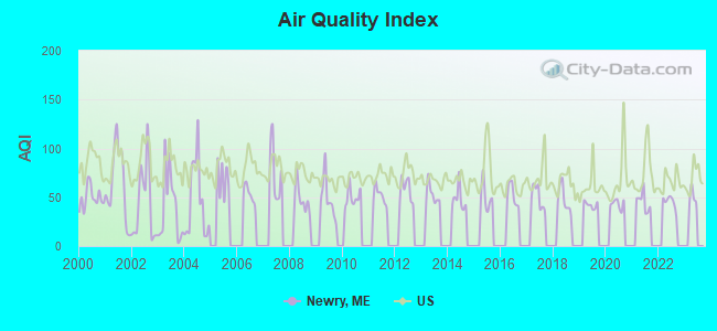
Air Quality Index (AQI) level in 2022 was 45.0. This is significantly better than average.
| City: | 45.0 |
| U.S.: | 72.6 |
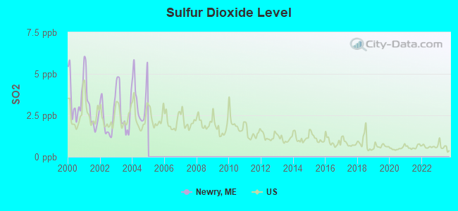
Sulfur Dioxide (SO2) [ppb] level in 2004 was 3.52. This is significantly worse than average. Closest monitor was 14.3 miles away from the city center.
| City: | 3.52 |
| U.S.: | 1.51 |
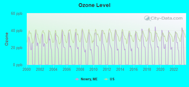
Ozone [ppb] level in 2022 was 27.7. This is better than average. Closest monitor was 16.5 miles away from the city center.
| City: | 27.7 |
| U.S.: | 33.3 |
Earthquake activity:
Newry-area historical earthquake activity is significantly above Maine state average. It is 75% smaller than the overall U.S. average.On 4/20/2002 at 10:50:47, a magnitude 5.3 (5.3 ML, Depth: 3.0 mi, Class: Moderate, Intensity: VI - VII) earthquake occurred 141.2 miles away from Newry center
On 4/20/2002 at 10:50:47, a magnitude 5.2 (5.2 MB, 4.2 MS, 5.2 MW, 5.0 MW) earthquake occurred 142.2 miles away from Newry center
On 10/7/1983 at 10:18:46, a magnitude 5.3 (5.1 MB, 5.3 LG, 5.1 ML) earthquake occurred 177.9 miles away from Newry center
On 10/16/2012 at 23:12:25, a magnitude 4.7 (4.7 ML, Depth: 10.0 mi, Class: Light, Intensity: IV - V) earthquake occurred 63.3 miles away from Newry center
On 1/19/1982 at 00:14:42, a magnitude 4.7 (4.5 MB, 4.7 MD, 4.5 LG) earthquake occurred 79.1 miles away from Newry center
On 8/21/1996 at 07:54:14, a magnitude 3.8 (3.8 LG, 3.6 LG, Depth: 6.2 mi, Class: Light, Intensity: II - III) earthquake occurred 33.8 miles away from the city center
Magnitude types: regional Lg-wave magnitude (LG), body-wave magnitude (MB), duration magnitude (MD), local magnitude (ML), surface-wave magnitude (MS), moment magnitude (MW)
Natural disasters:
The number of natural disasters in Oxford County (31) is a lot greater than the US average (15).Major Disasters (Presidential) Declared: 23
Emergencies Declared: 7
Causes of natural disasters: Floods: 19, Storms: 16, Snows: 7, Hurricanes: 3, Heavy Rains: 2, Blizzard: 1, Ice Storm: 1, Landslide: 1, Mudslide: 1, Snowfall: 1, Tropical Storm: 1, Wind: 1, Winter Storm: 1, Other: 2 (Note: some incidents may be assigned to more than one category).

Colleges/universities with over 2000 students nearest to Newry:
- University of Maine at Farmington (about 36 miles; Farmington, ME; Full-time enrollment: 2,036)
- Saint Joseph's College of Maine (about 50 miles; Standish, ME; FT enrollment: 2,010)
- University of Maine at Augusta (about 53 miles; Augusta, ME; FT enrollment: 3,204)
- University of Southern Maine (about 65 miles; Portland, ME; FT enrollment: 6,647)
- Southern Maine Community College (about 67 miles; South Portland, ME; FT enrollment: 4,666)
- Plymouth State University (about 67 miles; Plymouth, NH; FT enrollment: 4,838)
- University of New England (about 76 miles; Biddeford, ME; FT enrollment: 4,539)
Points of interest:
Notable locations in Newry: Sunday River Ski Area (A), Sunday River Cross Country Ski Center (B), Newry Fire Department - Sunday River Substation (C), Newry Fire Department (D). Display/hide their locations on the map
Cemeteries: Powers Cemetery (1), Sunday River Cemetery (2). Display/hide their locations on the map
Lake: Jims Pond (A). Display/hide its location on the map
Streams, rivers, and creeks: Wight Brook (A), Merrill Brook (B), Simons Brook (C), Eames Brook (D), Chase Hill Brook (E), Great Brook (F), Barkers Brook (G), Branch Brook (H). Display/hide their locations on the map
Park in Newry: Step Falls Preserve (1). Display/hide its location on the map
Drinking water stations with addresses in Newry and their reported violations in the past:
SUNDAY RIVER- ROADRUNNER SYSTEM (Population served: 978, Groundwater):Past monitoring violations:MATTERHORN SKI BAR (Population served: 750, Groundwater):
- 2 routine major monitoring violations
Past health violations:SUNDAY RIVER- JORDAN HOTEL (Population served: 374, Groundwater):Past monitoring violations:
- MCL, Monthly (TCR) - Between OCT-2007 and DEC-2007, Contaminant: Coliform. Follow-up actions: St Public Notif requested (NOV-16-2007), St Formal NOV issued (NOV-16-2007), St Public Notif received (NOV-16-2007), St Compliance achieved (DEC-19-2007)
- One routine major monitoring violation
- 2 regular monitoring violations
Past monitoring violations:SUNDAY RIVER- UPPER CISTERN SYSTEM (Population served: 300, Groundwater):
- 2 routine major monitoring violations
Past monitoring violations:SUNDAY RIVER- PEAK LODGE SYSTEM (Population served: 300, Groundwater):
- 2 routine major monitoring violations
Past monitoring violations:FALL LINE CONDOS @ SUNDAY RIVER (Population served: 256, Groundwater):
- One routine major monitoring violation
Past health violations:SOUTH RIDGE TOWNHOUSES (Population served: 180, Groundwater):Past monitoring violations:
- MCL, Acute (TCR) - In DEC-2008, Contaminant: Coliform. Follow-up actions: St Tech Assistance Visit (DEC-22-2008), St Compliance Meeting conducted (DEC-22-2008), St Boil Water Order (DEC-22-2008), St Formal NOV issued (DEC-22-2008), St Public Notif requested (DEC-22-2008), St Public Notif received (DEC-23-2008), St Intentional no-action (SEP-09-2011), St Compliance achieved (SEP-09-2011)
- MCL, Acute (TCR) - Between OCT-2008 and DEC-2008, Contaminant: Coliform. Follow-up actions: St Tech Assistance Visit (NOV-03-2008), St Compliance Meeting conducted (NOV-03-2008), St Boil Water Order (NOV-03-2008), St Formal NOV issued (NOV-03-2008), St Public Notif requested (NOV-03-2008), St Public Notif received (NOV-04-2008), St Intentional no-action (SEP-09-2011), St Compliance achieved (SEP-09-2011)
- One routine major monitoring violation
Past health violations:SUNDAY RIVER- NORTH PEAK I II III (Population served: 100, Groundwater):Past monitoring violations:
- MCL, Monthly (TCR) - In DEC-2012, Contaminant: Coliform. Follow-up actions: St Public Notif requested (DEC-17-2012), St Formal NOV issued (DEC-17-2012), St Compliance achieved (FEB-04-2013), St Public Notif received (FEB-21-2013)
- One routine major monitoring violation
- 3 regular monitoring violations
Past health violations:
- MCL, Monthly (TCR) - In AUG-2013, Contaminant: Coliform. Follow-up actions: St Public Notif requested (AUG-16-2013), St Formal NOV issued (AUG-16-2013), St Public Notif received (SEP-05-2013), St Compliance achieved (SEP-25-2013)
Drinking water stations with addresses in Newry that have no violations reported:
- SUNDAY RIVER- SUNRISE CONDO (Population served: 201, Primary Water Source Type: Groundwater)
- SUNDAY RIVER- CASCADES CONDO (Population served: 180, Primary Water Source Type: Groundwater)
- SUNDAY RIVER- MERRILL BROOK II (Population served: 30, Primary Water Source Type: Groundwater)
| This town: | 2.1 people |
| Maine: | 2.3 people |
| This town: | 59.2% |
| Whole state: | 62.9% |
| This town: | 9.6% |
| Whole state: | 9.4% |
Likely homosexual households (counted as self-reported same-sex unmarried-partner households)
- Lesbian couples: 1.3% of all households
- Gay men: 0.0% of all households
| This town: | 5.0% |
| Whole state: | 10.9% |
| This town: | 2.1% |
| Whole state: | 4.1% |
For population 15 years and over in Newry:
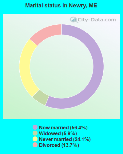
- Never married: 24.1%
- Now married: 56.4%
- Separated: 0.0%
- Widowed: 5.9%
- Divorced: 13.7%
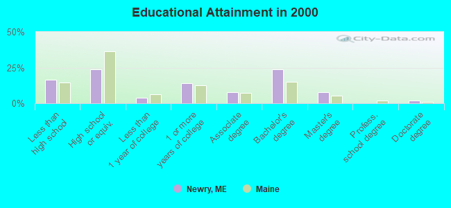
For population 25 years and over in Newry:
- High school or higher: 83.3%
- Bachelor's degree or higher: 33.3%
- Graduate or professional degree: 9.5%
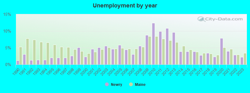
- Unemployed: 2.8%
- Mean travel time to work (commute): 21.8 minutes
| Here: | 11.2 |
| Maine average: | 11.2 |
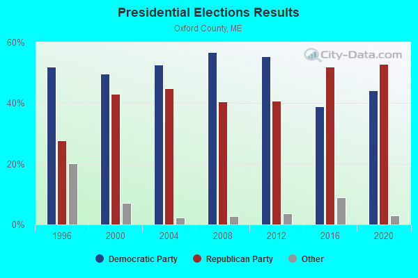
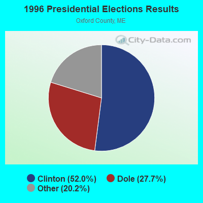
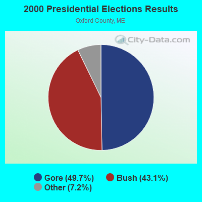
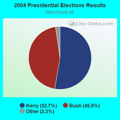


Graphs represent county-level data. Detailed 2008 Election Results
Religion statistics for Newry, ME (based on Oxford County data)
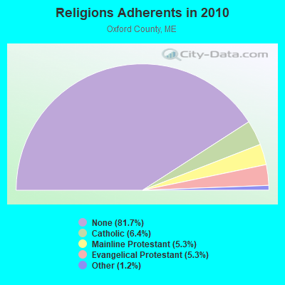
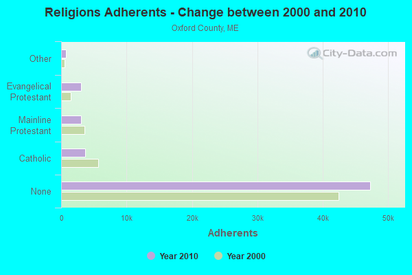
| Religion | Adherents | Congregations |
|---|---|---|
| Catholic | 3,708 | 7 |
| Mainline Protestant | 3,085 | 45 |
| Evangelical Protestant | 3,045 | 37 |
| Other | 719 | 14 |
| None | 47,276 | - |
Food Environment Statistics:
| This county: | 2.47 / 10,000 pop. |
| State: | 2.80 / 10,000 pop. |
| Here: | 0.35 / 10,000 pop. |
| State: | 0.14 / 10,000 pop. |
| Here: | 2.29 / 10,000 pop. |
| State: | 2.20 / 10,000 pop. |
| Oxford County: | 7.94 / 10,000 pop. |
| Maine: | 5.75 / 10,000 pop. |
| Oxford County: | 9.35 / 10,000 pop. |
| Maine: | 11.02 / 10,000 pop. |
| This county: | 7.6% |
| State: | 8.2% |
| Oxford County: | 25.6% |
| Maine: | 25.0% |
Businesses in Newry, ME
- Nike: 1
- Vans: 2
Strongest AM radio stations in Newry:
- WTME (780 AM; 10 kW; RUMFORD, ME; Owner: MOUNTAIN VALLEY BROADCASTING, INC.)
- WRKO (680 AM; 50 kW; BOSTON, MA; Owner: ENTERCOM BOSTON LICENSE, LLC)
- WMTW (870 AM; 10 kW; GORHAM, ME; Owner: RADIO PARTNERS OF MAINE, L.P.)
- WMOU (1230 AM; 1 kW; BERLIN, NH; Owner: JERICHO BROADCASTING COMPANY, L.L.C.)
- WCHP (760 AM; 35 kW; CHAMPLAIN, NY; Owner: CHAMPLAIN RADIO, INC.)
- WSKW (1160 AM; 10 kW; SKOWHEGAN, ME; Owner: MOUNTAIN WIRELESS, INCORPORATED)
- WEEI (850 AM; 50 kW; BOSTON, MA; Owner: ENTERCOM BOSTON LICENSE, LLC)
- WGAN (560 AM; 5 kW; PORTLAND, ME; Owner: SAGA COMMUNICATIONS OF NEW ENGLAND, LLC)
- WCRN (830 AM; 50 kW; WORCESTER, MA; Owner: CARTER BROADCASTING CORPORATION)
- WNNZ (640 AM; 50 kW; WESTFIELD, MA; Owner: CLEAR CHANNEL BROADCASTING LICENSES, INC.)
- WBZ (1030 AM; 50 kW; BOSTON, MA; Owner: INFINITY BROADCASTING OPERATIONS, INC.)
- WLAM (1470 AM; 5 kW; LEWISTON, ME; Owner: RADIO PARTNERS OF MAINE, L.P.)
- WKOX (1200 AM; 50 kW; FRAMINGHAM, MA; Owner: CAPSTAR TX LIMITED PARTNERSHIP)
Strongest FM radio stations in Newry:
- WLOB-FM (96.3 FM; RUMFORD, ME; Owner: ATLANTIC COAST RADIO, LLC)
- WTBM (100.7 FM; MEXICO, ME; Owner: MOUNTAIN VALLEY BROADCASTING, INC.)
- WPKQ (103.7 FM; NORTH CONWAY, NH; Owner: CITADEL BROADCASTING COMPANY)
- WHOM (94.9 FM; MT. WASHINGTON, NH; Owner: CITADEL BROADCASTING COMPANY)
- WTOS-FM (105.1 FM; SKOWHEGAN, ME; Owner: CAPSTAR TX LIMITED PARTNERSHIP)
- WMEA (90.1 FM; PORTLAND, ME; Owner: MAINE PUBLIC BROADCASTING CORPORATION)
- WVFM (105.7 FM; CAMPTON, NH; Owner: DEVON BROADCASTING COMPANY, INC.)
- WSCY (106.9 FM; MOULTONBOROUGH, NH; Owner: NORTHEAST COMMUNICATIONS CORPORATION)
- WGMT (97.7 FM; LYNDON, VT; Owner: VERMONT BROADCAST ASSOCIATES, INC.)
- WBLM (102.9 FM; PORTLAND, ME; Owner: CITADEL BROADCASTING COMPANY)
- WMTK (106.3 FM; LITTLETON, NH; Owner: VERMONT BROADCAST ASSOCIATES, INC.)
- WXXS (102.3 FM; LANCASTER, NH; Owner: BARRY P. LUNDERVILLE)
- WOXO-FM (92.7 FM; NORWAY, ME; Owner: TRI-COUNTY BROADCASTING, INC.)
- WEVC (107.1 FM; GORHAM, NH; Owner: NEW HAMPSHIRE PUBLIC RADIO, INCORPORATED)
TV broadcast stations around Newry:
- WGME-TV (Channel 13; PORTLAND, ME; Owner: WGME LICENSEE, LLC)
- WMTW-TV (Channel 8; POLAND SPRING, ME; Owner: WMTW BROADCAST GROUP, LLC)
- WCSH (Channel 6; PORTLAND, ME; Owner: PACIFIC AND SOUTHERN COMPANY, INC.)
- W04BS (Channel 4; BETHEL, ETC., ME; Owner: MAINE PUBLIC BROADCASTING CORPORATION)
- National Bridge Inventory (NBI) Statistics
- 7Number of bridges
- 43ft / 13.0mTotal length
- 211,474Total average daily traffic
- 10,570Total average daily truck traffic
- 15,215Total future (year 2034) average daily traffic
FCC Registered Cell Phone Towers:
1 (See the full list of FCC Registered Cell Phone Towers in Newry)FCC Registered Antenna Towers:
27 (See the full list of FCC Registered Antenna Towers)FCC Registered Broadcast Land Mobile Towers:
1- Top Barker Mtn (Lat: 44.457000 Lon: -70.867028), Call Sign: KWG963, Licensee ID: L00047522,
Assigned Frequencies: 463.300 MHz, 154.515 MHz, Grant Date: 10/12/2002, Expiration Date: 11/20/2012, Cancellation Date: 01/26/2013, Registrant: Sunday River Skiway Corp, Bethel, ME 04217
FCC Registered Amateur Radio Licenses:
2- Call Sign: KB1GIF, Licensee ID: L00328530, Grant Date: 02/22/2001, Expiration Date: 02/22/2011, Cancellation Date: 02/23/2013, Certifier: Jeffrey D Scribner, Registrant: Jeffrey D Scribner, Hc 61 Box 340 Rt 26, Newry, ME 04261
- Call Sign: KB1WDL, Licensee ID: L01665950, Grant Date: 08/05/2021, Expiration Date: 10/11/2031, Certifier: Edward E Baker, Registrant: Edward E Baker, Newry, ME 04261-0272
FAA Registered Aircraft:
1- Aircraft: CESSNA 172N (Category: Land, Seats: 4, Weight: Up to 12,499 Pounds, Speed: 105 mph), Engine: LYCOMING 0-320 SERIES (180 HP) (Reciprocating)
N-Number: 738MW, N738MW, N-738MW, Serial Number: 17270093, Year manufactured: 1977, Airworthiness Date: 12/20/1977, Certificate Issue Date: 07/28/2008
Registrant (Individual): Gary H Drown, Po Box 223, Newry, ME 04261
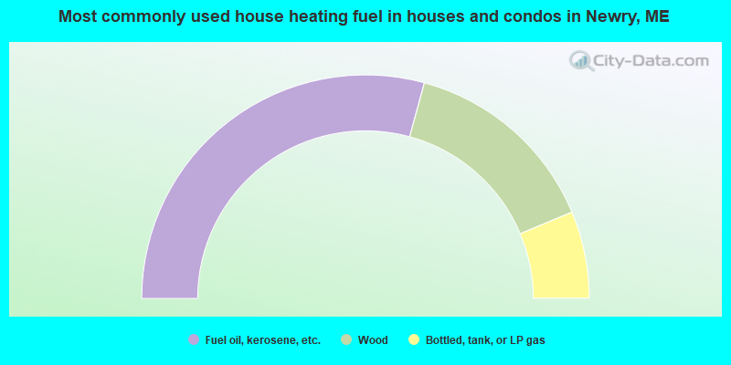
- 58.5%Fuel oil, kerosene, etc.
- 28.9%Wood
- 12.6%Bottled, tank, or LP gas
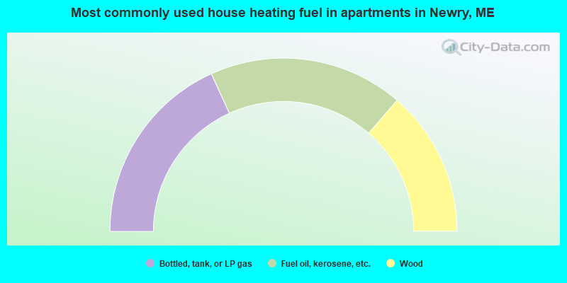
- 36.4%Bottled, tank, or LP gas
- 36.4%Fuel oil, kerosene, etc.
- 27.3%Wood
Newry compared to Maine state average:
- Unemployed percentage significantly below state average.
- Black race population percentage significantly below state average.
- Hispanic race population percentage below state average.
- Median age above state average.
- Foreign-born population percentage below state average.
- Renting percentage below state average.
- Length of stay since moving in significantly above state average.
- Number of rooms per house significantly below state average.
- House age significantly below state average.

|
Total of 2 patent applications in 2008-2024.