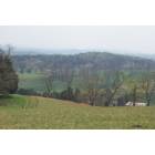
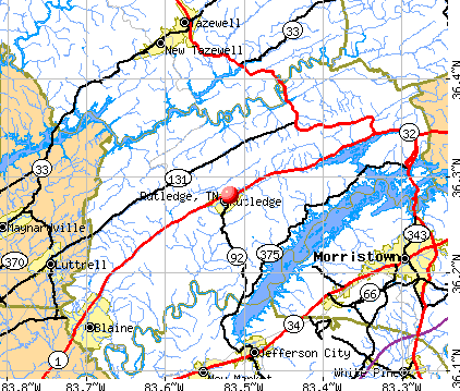
Rutledge, Tennessee
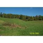
Rutledge: Buffalo Springs Area
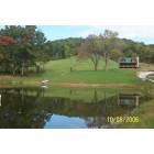
Rutledge: A Hill In Bean Station TN 37708
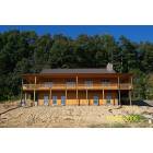
Rutledge: Cabin in The Meadow
Rutledge: 576 Holston Shores Rutledge TN 37861
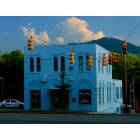
Rutledge: Police building in Rutledgee, Tenness
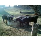
Rutledge: A typical scene in rural Rutledge...moo!
- add
your


Submit your own pictures of this town and show them to the world
- OSM Map
- General Map
- Google Map
- MSN Map
Population change since 2000: +12.0%
 |
| Males: 658 | |
| Females: 672 |
| Median resident age: | 45.4 years |
| Tennessee median age: | 39.2 years |
Zip codes: 37861.
| Rutledge: | $31,324 |
| TN: | $65,254 |
Estimated per capita income in 2022: $25,781 (it was $14,477 in 2000)
Rutledge town income, earnings, and wages data
Estimated median house or condo value in 2022: $160,499 (it was $66,200 in 2000)
| Rutledge: | $160,499 |
| TN: | $284,800 |
Mean prices in 2022: all housing units: $151,923; detached houses: $190,174; mobile homes: $66,943
Median gross rent in 2022: $577.
(17.0% for White Non-Hispanic residents, 100.0% for Black residents, 82.6% for Hispanic or Latino residents, 73.2% for two or more races residents)
Detailed information about poverty and poor residents in Rutledge, TN

Compare current foreclosures near Rutledge, TN:
| Photo | Address | Area | Beds / Baths | Price | Details |
|---|---|---|---|---|---|

|
#1
Lakeshore Dr
Rutledge, TN 37861
|
1,904 sq. feet
|
1 baths - beds |
show details | |

|
#2
W Hills Rd
Rutledge, TN 37861
|
960 sq. feet
|
1 baths - beds |
show details | |

|
#3
Shady Glen Ln
Rutledge, TN 37861
|
560 sq. feet
|
1 baths - beds |
show details | |

|
#4
Clinch View Apts # 201
Rutledge, TN 37861
|
- sq. feet
|
- baths - beds |
show details | |

|
#5
Highway 11w S
Rutledge, TN 37861
|
- sq. feet
|
- baths - beds |
show details | |

|
#6
Clint Williams Rd
Rutledge, TN 37861
|
728 sq. feet
|
- baths - beds |
show details | |

|
#7
Joppa School Rd
Rutledge, TN 37861
|
- sq. feet
|
- baths - beds |
show details | |

|
#8
Spoon Hollow Rd
Rutledge, TN 37861
|
- sq. feet
|
- baths - beds |
show details | |

|
#9
Rogers Dr
Rutledge, TN 37861
|
- sq. feet
|
- baths - beds |
show details | |

|
#10
Rosedale Ave
Morristown, TN 37813
|
792 sq. feet
|
1 baths 2 beds |
$165,000
|
show details |
| Photo | Address | Area | Beds / Baths | Price | Details |
|---|---|---|---|---|---|

|
#11
Highway 131
Washburn, TN 37888
|
1,400 sq. feet
|
2 baths 3 beds |
$325,000
|
show details |

|
#12
Patterson Town Rd
Blaine, TN 37709
|
1,026 sq. feet
|
1 baths - beds |
$24,900
|
show details |

|
#13
Cherrybrook Ln
Talbott, TN 37877
|
1,400 sq. feet
|
2 baths 3 beds |
show details | |

|
#14
Jesse Baker Ln
Jefferson City, TN 37760
|
- sq. feet
|
2 baths 4 beds |
show details | |

|
#15
Le Conte St
Morristown, TN 37814
|
2,049 sq. feet
|
2 baths 2 beds |
show details | |

|
#16
Brookline Ct
Jefferson City, TN 37760
|
1,316 sq. feet
|
3 baths - beds |
show details | |

|
#17
Guinn Dr
New Market, TN 37820
|
2,280 sq. feet
|
2 baths 3 beds |
show details | |

|
#18
Union Ave
Morristown, TN 37813
|
949 sq. feet
|
1 baths - beds |
show details | |

|
#19
Hinchey Hollow Rd
Jefferson City, TN 37760
|
1,536 sq. feet
|
2 baths - beds |
show details | |

|
#20
Barker Rd
New Tazewell, TN 37825
|
1,080 sq. feet
|
2 baths - beds |
show details |
| Photo | Address | Area | Beds / Baths | Price | Details |
|---|---|---|---|---|---|

|
#21
Sallings Rd
Luttrell, TN 37779
|
1,196 sq. feet
|
1 baths - beds |
show details | |

|
#22
Highway 61 E
Luttrell, TN 37779
|
1,280 sq. feet
|
2 baths - beds |
show details | |

|
#23
Highway 61 E
Luttrell, TN 37779
|
2,040 sq. feet
|
1 baths - beds |
show details | |

|
#24
Reese St
Morristown, TN 37814
|
2,064 sq. feet
|
2 baths - beds |
show details | |

|
#25
Ellis St
Bean Station, TN 37708
|
1,820 sq. feet
|
2 baths - beds |
show details | |

|
#26
Crown Cir
Morristown, TN 37814
|
1,343 sq. feet
|
1 baths - beds |
show details | |

|
#27
Keith Dr
Maynardville, TN 37807
|
2,528 sq. feet
|
2 baths - beds |
show details | |

|
#28
E 2nd North St
Morristown, TN 37814
|
1,275 sq. feet
|
1 baths - beds |
show details | |

|
#29
Spring Creek Dr
Morristown, TN 37814
|
2,480 sq. feet
|
2 baths - beds |
show details | |

|
#30
Lynn Dr
Maynardville, TN 37807
|
1,904 sq. feet
|
2 baths - beds |
show details |
| Photo | Address | Area | Beds / Baths | Price | Details |
|---|---|---|---|---|---|

|
#31
Lennie Ave
Morristown, TN 37813
|
1,152 sq. feet
|
1 baths - beds |
show details | |

|
#32
Danbury Dr
Morristown, TN 37813
|
2,111 sq. feet
|
2 baths - beds |
show details | |

|
#33
Cotter Rd
Jefferson City, TN 37760
|
1,508 sq. feet
|
2 baths - beds |
show details | |

|
#34
Hilltop Dr
Morristown, TN 37814
|
1,050 sq. feet
|
1 baths - beds |
show details | |

|
#35
Shelton Rd
New Market, TN 37820
|
1,296 sq. feet
|
2 baths - beds |
show details | |

|
#36
Nances Ferry Rd
New Market, TN 37820
|
1,107 sq. feet
|
1 baths - beds |
show details | |

|
#37
Carter Dr
Jefferson City, TN 37760
|
2,500 sq. feet
|
2 baths - beds |
show details | |

|
#38
Mallory Dr
New Tazewell, TN 37825
|
1,326 sq. feet
|
2 baths - beds |
show details | |

|
#39
Cedar Ln
Tazewell, TN 37879
|
1,596 sq. feet
|
2 baths - beds |
show details | |

|
#40
W 6th North St
Morristown, TN 37814
|
2,112 sq. feet
|
2 baths - beds |
show details |
| Photo | Address | Area | Beds / Baths | Price | Details |
|---|---|---|---|---|---|

|
#41
Clear Springs Rd
Mascot, TN 37806
|
1,000 sq. feet
|
- baths - beds |
show details | |

|
#42
Mill Wheel Rd
Morristown, TN 37814
|
1,175 sq. feet
|
1 baths - beds |
show details | |

|
#43
Whitaker St
Tazewell, TN 37879
|
1,008 sq. feet
|
1 baths - beds |
show details | |

|
#44
N Henry St
Morristown, TN 37814
|
1,080 sq. feet
|
2 baths - beds |
show details | |

|
#45
Kirkham Rd
Bean Station, TN 37708
|
1,092 sq. feet
|
1 baths - beds |
show details | |

|
#46
Whitaker St
Tazewell, TN 37879
|
1,537 sq. feet
|
1 baths - beds |
show details | |

|
#47
Madison St
Morristown, TN 37814
|
768 sq. feet
|
1 baths - beds |
show details | |

|
#48
Clancy Ave
Morristown, TN 37814
|
1,242 sq. feet
|
2 baths - beds |
show details | |

|
#49
Carriger St
Morristown, TN 37814
|
750 sq. feet
|
1 baths - beds |
show details | |

|
Check over 1 million property listings on Foreclosure.com!
|
browse all offers | |||


- 1,46492.8%White alone
- 493.1%Hispanic
- 241.5%Two or more races
- 191.2%Black alone
- 100.6%Asian alone
- 30.2%American Indian alone
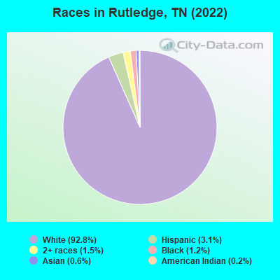
Races in Rutledge detailed stats: ancestries, foreign born residents, place of birth
According to our research of Tennessee and other state lists, there were 24 registered sex offenders living in Rutledge, Tennessee as of April 30, 2024.
The ratio of all residents to sex offenders in Rutledge is 57 to 1.
Type |
2009 |
2010 |
2011 |
2012 |
2013 |
2014 |
2015 |
2016 |
2017 |
2018 |
2019 |
2020 |
2021 |
2022 |
|---|---|---|---|---|---|---|---|---|---|---|---|---|---|---|
| Murders (per 100,000) | 0 (0.0) | 0 (0.0) | 0 (0.0) | 0 (0.0) | 0 (0.0) | 0 (0.0) | 0 (0.0) | 0 (0.0) | 0 (0.0) | 0 (0.0) | 0 (0.0) | 0 (0.0) | 0 (0.0) | 0 (0.0) |
| Rapes (per 100,000) | 1 (77.2) | 1 (89.1) | 0 (0.0) | 0 (0.0) | 2 (177.0) | 0 (0.0) | 0 (0.0) | 0 (0.0) | 0 (0.0) | 0 (0.0) | 0 (0.0) | 0 (0.0) | 1 (73.6) | 0 (0.0) |
| Robberies (per 100,000) | 0 (0.0) | 0 (0.0) | 0 (0.0) | 0 (0.0) | 1 (88.5) | 0 (0.0) | 0 (0.0) | 0 (0.0) | 0 (0.0) | 0 (0.0) | 0 (0.0) | 0 (0.0) | 0 (0.0) | 0 (0.0) |
| Assaults (per 100,000) | 2 (154.4) | 3 (267.4) | 1 (88.3) | 2 (175.7) | 2 (177.0) | 3 (264.3) | 1 (85.0) | 0 (0.0) | 2 (166.5) | 1 (73.6) | 0 (0.0) | 0 (0.0) | 1 (73.6) | 0 (0.0) |
| Burglaries (per 100,000) | 4 (308.9) | 9 (802.1) | 10 (883.4) | 9 (790.9) | 13 (1,150) | 4 (352.4) | 2 (170.1) | 4 (333.3) | 7 (582.8) | 8 (589.1) | 6 (443.8) | 6 (440.5) | 5 (368.2) | 3 (234.0) |
| Thefts (per 100,000) | 21 (1,622) | 34 (3,030) | 52 (4,594) | 34 (2,988) | 37 (3,274) | 21 (1,850) | 16 (1,361) | 21 (1,750) | 9 (749.4) | 13 (957.3) | 18 (1,331) | 25 (1,836) | 13 (957.3) | 5 (390.0) |
| Auto thefts (per 100,000) | 4 (308.9) | 2 (178.3) | 2 (176.7) | 3 (263.6) | 1 (88.5) | 2 (176.2) | 1 (85.0) | 0 (0.0) | 2 (166.5) | 3 (220.9) | 1 (74.0) | 2 (146.8) | 2 (147.3) | 2 (156.0) |
| Arson (per 100,000) | 0 (0.0) | 0 (0.0) | 0 (0.0) | 0 (0.0) | 0 (0.0) | 0 (0.0) | 0 (0.0) | 0 (0.0) | 0 (0.0) | 0 (0.0) | 0 (0.0) | 0 (0.0) | 0 (0.0) | 0 (0.0) |
| City-Data.com crime index | 203.9 | 316.4 | 277.4 | 231.1 | 422.1 | 165.6 | 90.1 | 93.3 | 117.4 | 111.9 | 90.2 | 116.0 | 149.5 | 44.5 |
The City-Data.com crime index weighs serious crimes and violent crimes more heavily. Higher means more crime, U.S. average is 246.1. It adjusts for the number of visitors and daily workers commuting into cities.
Crime rate in Rutledge detailed stats: murders, rapes, robberies, assaults, burglaries, thefts, arson
Full-time law enforcement employees in 2021, including police officers: 3 (3 officers - 3 male; 0 female).
| Officers per 1,000 residents here: | 2.21 |
| Tennessee average: | 2.57 |
 Recent articles from our blog. Our writers, many of them Ph.D. graduates or candidates, create easy-to-read articles on a wide variety of topics.


 | Nashville Development Thread (1192 replies) |
| 11 Most Picturesque Towns in Tennessee (23 replies) |
| Need Help Narrowing Down Towns in Tennessee (25 replies) |
| Can you tell me about Morristown, Bean Station, etc? (3 replies) |
| Moving in Oct for a job in Knoxville (1 reply) |
| Another Post Asking for Location Info! (6 replies) |
Latest news from Rutledge, TN collected exclusively by city-data.com from local newspapers, TV, and radio stations
Ancestries: American (41.6%), English (14.1%), Irish (11.9%), Belgian (3.4%), German (2.6%), Scottish (2.6%).
Current Local Time: EST time zone
Incorporated in 1797
Elevation: 1015 feet
Land area: 4.69 square miles.
Population density: 284 people per square mile (very low).
67 residents are foreign born (2.4% Latin America, 0.6% Asia, 0.6% North America, 0.5% Europe).
| This town: | 4.2% |
| Tennessee: | 5.4% |
Median real estate property taxes paid for housing units with mortgages in 2022: $546 (0.3%)
Median real estate property taxes paid for housing units with no mortgage in 2022: $506 (0.4%)
Nearest city with pop. 50,000+: Knoxville, TN  (31.8 miles , pop. 173,890).
Nearest city with pop. 200,000+: Fayette, KY (132.5 miles , pop. 260,512).
Nearest city with pop. 1,000,000+: Chicago, IL (444.7 miles , pop. 2,896,016).
Nearest cities:
), ), ), ), Latitude: 36.28 N, Longitude: 83.52 W
Area code: 865

Single-family new house construction building permits:
- 2014: 14 buildings, average cost: $171,200
- 2013: 17 buildings, average cost: $182,500
| Here: | 3.2% |
| Tennessee: | 3.0% |
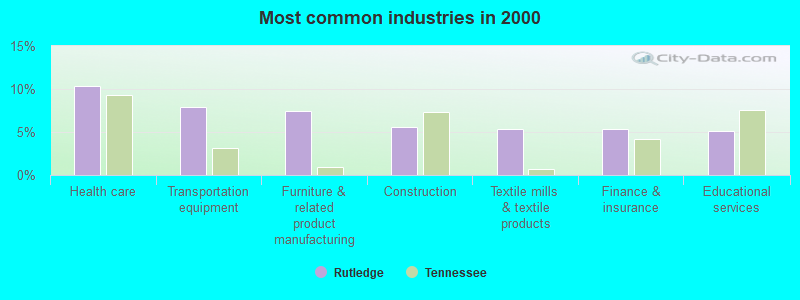
- Health care (10.4%)
- Transportation equipment (7.9%)
- Furniture & related product manufacturing (7.4%)
- Construction (5.5%)
- Textile mills & textile products (5.3%)
- Finance & insurance (5.3%)
- Educational services (5.1%)
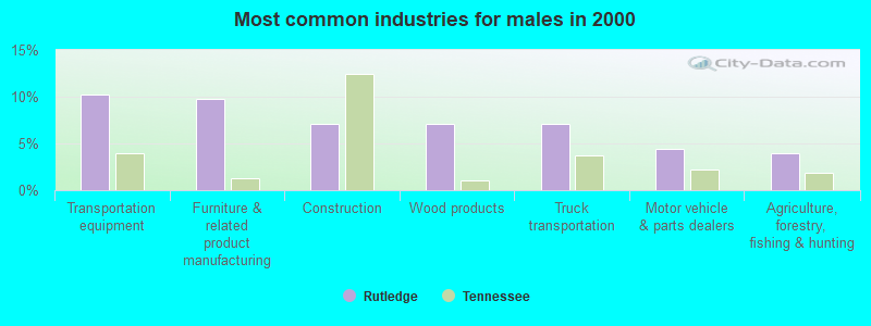
- Transportation equipment (10.2%)
- Furniture & related product manufacturing (9.8%)
- Construction (7.1%)
- Wood products (7.1%)
- Truck transportation (7.1%)
- Motor vehicle & parts dealers (4.4%)
- Agriculture, forestry, fishing & hunting (4.0%)
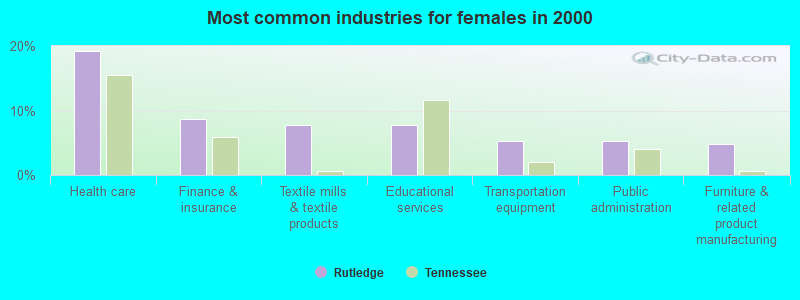
- Health care (19.2%)
- Finance & insurance (8.7%)
- Textile mills & textile products (7.7%)
- Educational services (7.7%)
- Transportation equipment (5.3%)
- Public administration (5.3%)
- Furniture & related product manufacturing (4.8%)
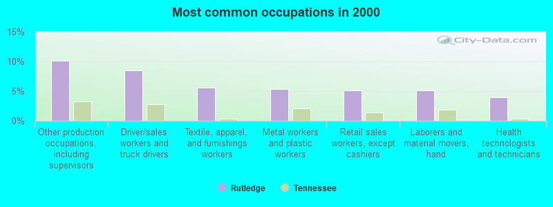
- Other production occupations, including supervisors (10.2%)
- Driver/sales workers and truck drivers (8.5%)
- Textile, apparel, and furnishings workers (5.5%)
- Metal workers and plastic workers (5.3%)
- Retail sales workers, except cashiers (5.1%)
- Laborers and material movers, hand (5.1%)
- Health technologists and technicians (3.9%)
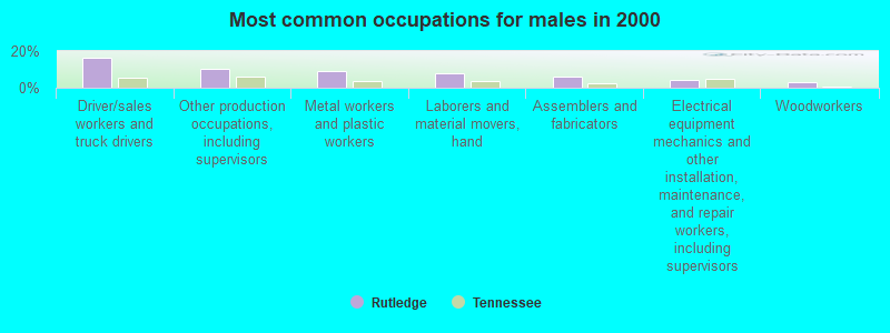
- Driver/sales workers and truck drivers (16.4%)
- Other production occupations, including supervisors (10.2%)
- Metal workers and plastic workers (9.3%)
- Laborers and material movers, hand (8.0%)
- Assemblers and fabricators (6.2%)
- Electrical equipment mechanics and other installation, maintenance, and repair workers, including supervisors (4.0%)
- Woodworkers (3.1%)
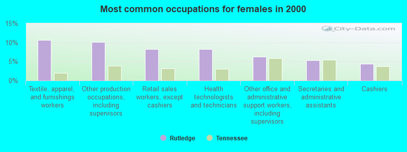
- Textile, apparel, and furnishings workers (10.6%)
- Other production occupations, including supervisors (10.1%)
- Retail sales workers, except cashiers (8.2%)
- Health technologists and technicians (8.2%)
- Other office and administrative support workers, including supervisors (6.2%)
- Secretaries and administrative assistants (5.3%)
- Cashiers (4.3%)
Average climate in Rutledge, Tennessee
Based on data reported by over 4,000 weather stations


|
|


(lower is better)

Air Quality Index (AQI) level in 2023 was 59.3. This is better than average.
| City: | 59.3 |
| U.S.: | 72.6 |
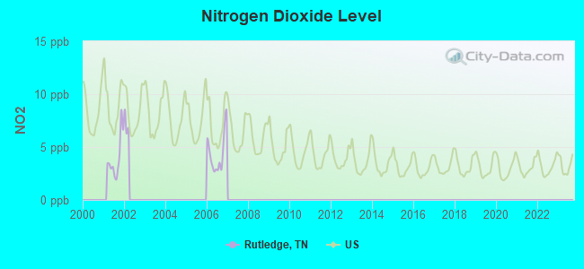
Nitrogen Dioxide (NO2) [ppb] level in 2006 was 4.41. This is about average. Closest monitor was 15.2 miles away from the city center.
| City: | 4.41 |
| U.S.: | 5.11 |
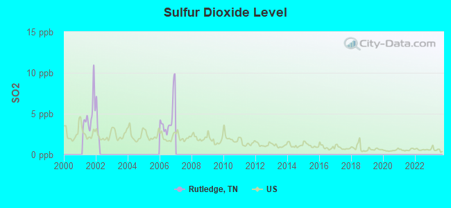
Sulfur Dioxide (SO2) [ppb] level in 2006 was 4.50. This is significantly worse than average. Closest monitor was 15.2 miles away from the city center.
| City: | 4.50 |
| U.S.: | 1.51 |
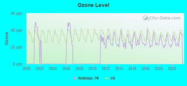
Ozone [ppb] level in 2023 was 32.0. This is about average. Closest monitor was 8.8 miles away from the city center.
| City: | 32.0 |
| U.S.: | 33.3 |
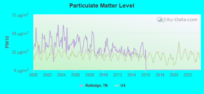
Particulate Matter (PM10) [µg/m3] level in 2015 was 26.0. This is worse than average. Closest monitor was 11.3 miles away from the city center.
| City: | 26.0 |
| U.S.: | 19.2 |
Tornado activity:
Rutledge-area historical tornado activity is significantly below Tennessee state average. It is 52% smaller than the overall U.S. average.
On 5/9/1988, a category F3 (max. wind speeds 158-206 mph) tornado 23.3 miles away from the Rutledge town center killed one person and injured 15 people and caused between $5,000,000 and $50,000,000 in damages.
On 2/21/1993, a category F3 tornado 28.1 miles away from the town center injured 3 people and caused between $500,000 and $5,000,000 in damages.
Earthquake activity:
Rutledge-area historical earthquake activity is significantly above Tennessee state average. It is 62% greater than the overall U.S. average.On 7/27/1980 at 18:52:21, a magnitude 5.2 (5.1 MB, 4.7 MS, 5.0 UK, 5.2 UK, Class: Moderate, Intensity: VI - VII) earthquake occurred 135.2 miles away from Rutledge center
On 11/30/1973 at 07:48:41, a magnitude 4.7 (4.7 MB, 4.6 ML, Class: Light, Intensity: IV - V) earthquake occurred 41.5 miles away from Rutledge center
On 8/9/2020 at 12:07:37, a magnitude 5.1 (5.1 MW, Depth: 4.7 mi) earthquake occurred 135.7 miles away from the city center
On 8/23/2011 at 17:51:04, a magnitude 5.8 (5.8 MW, Depth: 3.7 mi) earthquake occurred 327.9 miles away from the city center
On 4/29/2003 at 08:59:39, a magnitude 4.9 (4.4 MB, 4.6 MW, 4.9 LG) earthquake occurred 171.5 miles away from Rutledge center
On 8/2/1974 at 08:52:09, a magnitude 4.9 (4.3 MB, 4.9 LG) earthquake occurred 176.5 miles away from the city center
Magnitude types: regional Lg-wave magnitude (LG), body-wave magnitude (MB), local magnitude (ML), surface-wave magnitude (MS), moment magnitude (MW)
Natural disasters:
The number of natural disasters in Grainger County (14) is near the US average (15).Major Disasters (Presidential) Declared: 9
Emergencies Declared: 2
Causes of natural disasters: Floods: 9, Storms: 7, Tornadoes: 3, Heavy Rains: 2, Winter Storms: 2, Fire: 1, Flash Flood: 1, Hurricane: 1, Landslide: 1, Mudslide: 1, Snowfall: 1, Wind: 1, Other: 1 (Note: some incidents may be assigned to more than one category).

Hospitals and medical centers in Rutledge:
- RIDGEVIEW TERRACE CONV NURSING CTR (RTE 2 COFFEY LANE)
- RIDGEVIEW TERRACE OF LIFE CARE (PO BOX 26 COFFEY LANE)
Other hospitals and medical centers near Rutledge:
- LIFE CARE CENTER OF JEFFERSON CITY (Nursing Home, about 12 miles away; JEFFERSON CITY, TN)
- LIFE CARE CENTER OF MORRISTOWN (Nursing Home, about 12 miles away; MORRISTOWN, TN)
- CLAIBORNE HOME HEALTH CARE (Home Health Center, about 12 miles away; TAZEWELL, TN)
- JEFFERSON CITY HEALTH AND REHAB CENTER (Nursing Home, about 12 miles away; JEFFERSON CITY, TN)
- MORRISTOWN DIALYSIS CENTER (Dialysis Facility, about 13 miles away; MORRISTOWN, TN)
- APPALACHIAN DIALYSIS (Dialysis Facility, about 13 miles away; NEW TAZEWELL, TN)
- AMEDISYS HOME HEALTH OF TENNESSEE (Home Health Center, about 13 miles away; TAZEWELL, TN)
Colleges/universities with over 2000 students nearest to Rutledge:
- Walters State Community College (about 15 miles; Morristown, TN; Full-time enrollment: 4,359)
- Lincoln Memorial University (about 23 miles; Harrogate, TN; FT enrollment: 3,706)
- The University of Tennessee-Knoxville (about 33 miles; Knoxville, TN; FT enrollment: 25,483)
- Tusculum College (about 43 miles; Greeneville, TN; FT enrollment: 2,070)
- Pellissippi State Community College (about 43 miles; Knoxville, TN; FT enrollment: 7,271)
- University of the Cumberlands (about 48 miles; Williamsburg, KY; FT enrollment: 3,585)
- Southeast Kentucky Community and Technical College (about 56 miles; Cumberland, KY; FT enrollment: 2,196)
Public high schools in Rutledge:
Public elementary/middle schools in Rutledge:
- JOPPA ELEMENTARY (Students: 654, Location: 4745 RUTLEDGE PK, Grades: PK-6)
- RUTLEDGE MIDDLE SCHOOL (Students: 422, Location: 140 PIONEER DR, Grades: 7-8)
- RUTLEDGE ELEMENTARY SCHOOL (Students: 206, Location: 7480 RUTLEDGE PK, Grades: 2-6)
- RUTLEDGE PRIMARY (Location: 470 WATER ST, Grades: PK-1)
Points of interest:
Notable locations in Rutledge: Grainger County Rescue Squad (A), Rutledge Volunteer Fire Department (B). Display/hide their locations on the map
Churches in Rutledge include: Rutledge Presbyterian Church (A), Rutledge Methodist Church (B), Blue Spring Church (C). Display/hide their locations on the map
Cemeteries: Rutledge Cemetery (1), Blue Springs Cemetery (2). Display/hide their locations on the map
Park in Rutledge: Rutledge Recreational Park (1). Display/hide its location on the map
Birthplace of: Robert Taylor Jones - Politician.
Drinking water stations with addresses in Rutledge and their reported violations in the past:
RUTLEDGE WATER SYSTEM (Population served: 1,955, Purch surface water):Past monitoring violations:HOPPER'S BLUFF SUBDIVISION (Population served: 59, Groundwater):
- Monitoring, Routine (IDSE) - Between JAN-2009 and MAR-2009, Contaminant: Total Haloacetic Acids (HAA5). Follow-up actions: St Compliance achieved (FEB-23-2009), St Public Notif requested (APR-28-2009), St Violation/Reminder Notice (APR-28-2009), St Public Notif received (JUN-15-2010)
- Monitoring, Routine (IDSE) - Between JAN-2009 and MAR-2009, Contaminant: TTHM. Follow-up actions: St Compliance achieved (FEB-23-2009), St Public Notif requested (APR-28-2009), St Violation/Reminder Notice (APR-28-2009), St Public Notif received (JUN-15-2010)
Past monitoring violations:GILMORE DOCK OPERATIONS LLC (Population served: 50, Groundwater):
- Monitoring and Reporting (DBP) - Between APR-2012 and JUN-2012, Contaminant: Chlorine. Follow-up actions: St Public Notif requested (JUN-01-2012), St Violation/Reminder Notice (JUN-01-2012), St Public Notif received (JUN-08-2012), St Compliance achieved (SEP-30-2012)
- 2 routine major monitoring violations
Past monitoring violations:HONEY CREEK SUBDIVISION (Population served: 45, Groundwater):
- One routine major monitoring violation
- 2 regular monitoring violations
Past monitoring violations:BOGGS SUBDIVISION (Population served: 45, Groundwater):
- One regular monitoring violation
Past monitoring violations:
- One regular monitoring violation
Drinking water stations with addresses in Rutledge that have no violations reported:
- GREENLEE OF MAY SPRINGS (Population served: 500, Primary Water Source Type: Groundwater)
- GREENLEE CG, RV & MARINE, LLC (Population served: 200, Primary Water Source Type: Groundwater)
| This town: | 2.2 people |
| Tennessee: | 2.5 people |
| This town: | 58.4% |
| Whole state: | 67.3% |
| This town: | 5.5% |
| Whole state: | 5.8% |
Likely homosexual households (counted as self-reported same-sex unmarried-partner households)
- Lesbian couples: 0.0% of all households
- Gay men: 0.4% of all households
127 people in nursing homes in 2000
27 people in local jails and other confinement facilities (including police lockups) in 2000
Banks with branches in Rutledge (2011 data):
- Citizens Bank and Trust Company of Grainger County: Citizens Bank And Trust Company Of G at 8335 Rutledge Pike, branch established on 1919/11/01; Cherokee Branch at 6680 Hwy 92, branch established on 2000/04/17. Info updated 2010/06/14: Bank assets: $181.4 mil, Deposits: $148.7 mil, local headquarters, positive income, 5 total offices, Holding Company: Citizens Of Grainger County Corporation
For population 15 years and over in Rutledge:
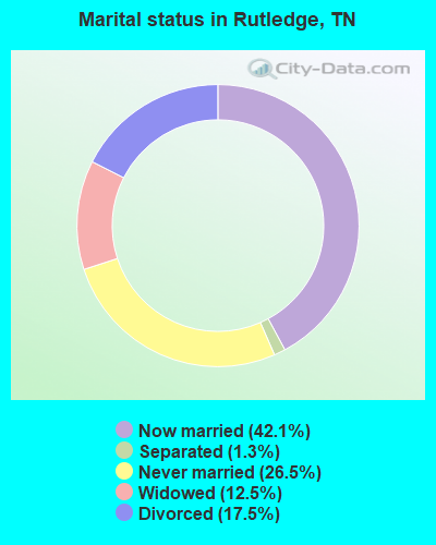
- Never married: 26.5%
- Now married: 42.1%
- Separated: 1.3%
- Widowed: 12.5%
- Divorced: 17.5%
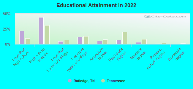
For population 25 years and over in Rutledge:
- High school or higher: 75.3%
- Bachelor's degree or higher: 11.2%
- Graduate or professional degree: 4.5%
- Unemployed: 5.5%
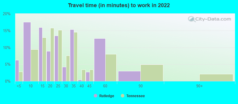
- Mean travel time to work (commute): 27.6 minutes
| Here: | 11.5 |
| Tennessee average: | 11.4 |
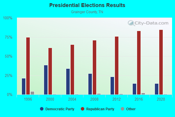
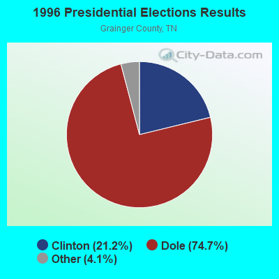
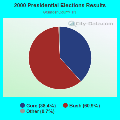
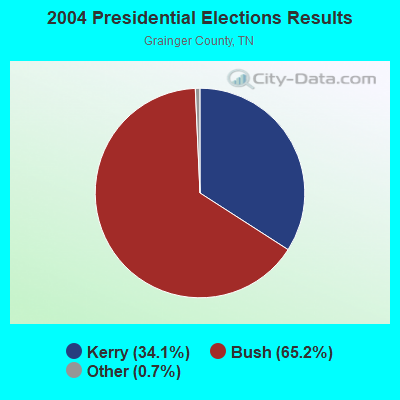
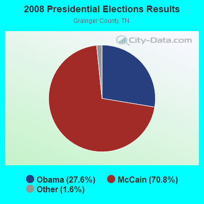
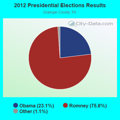

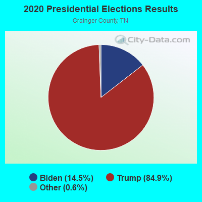
Graphs represent county-level data. Detailed 2008 Election Results
Religion statistics for Rutledge, TN (based on Grainger County data)
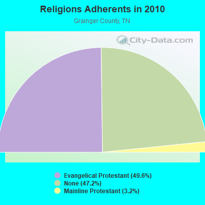
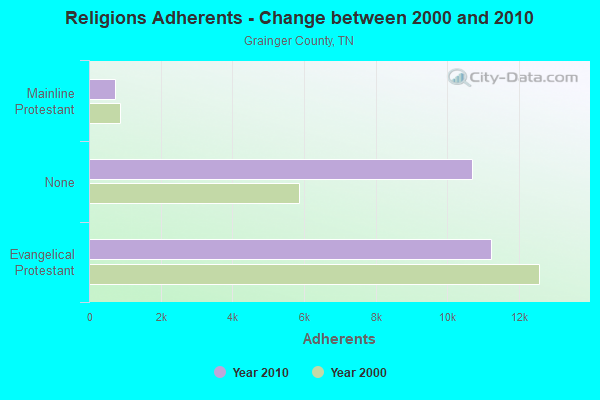
| Religion | Adherents | Congregations |
|---|---|---|
| Evangelical Protestant | 11,233 | 48 |
| Mainline Protestant | 728 | 10 |
| Other | 5 | 1 |
| Catholic | - | 1 |
| None | 10,691 | - |
Food Environment Statistics:
| Grainger County: | 2.22 / 10,000 pop. |
| Tennessee: | 1.99 / 10,000 pop. |
| Grainger County: | 5.77 / 10,000 pop. |
| State: | 5.16 / 10,000 pop. |
| Grainger County: | 1.78 / 10,000 pop. |
| State: | 6.56 / 10,000 pop. |
| Grainger County: | 11.5% |
| Tennessee: | 11.4% |
| This county: | 28.4% |
| Tennessee: | 30.2% |
| Grainger County: | 15.0% |
| Tennessee: | 13.5% |
Health and Nutrition:
| This city: | 46.2% |
| Tennessee: | 49.3% |
| This city: | 41.2% |
| Tennessee: | 46.1% |
| Rutledge: | 28.3 |
| State: | 28.8 |
| Here: | 19.5% |
| Tennessee: | 21.0% |
| Here: | 12.5% |
| State: | 10.5% |
| Here: | 6.7 |
| Tennessee: | 6.8 |
| This city: | 27.7% |
| Tennessee: | 33.9% |
| Rutledge: | 51.6% |
| State: | 55.9% |
| Here: | 82.7% |
| State: | 79.1% |
More about Health and Nutrition of Rutledge, TN Residents
| Local government employment and payroll (March 2022) | |||||
| Function | Full-time employees | Monthly full-time payroll | Average yearly full-time wage | Part-time employees | Monthly part-time payroll |
|---|---|---|---|---|---|
| Police Protection - Officers | 5 | $41,282 | $99,077 | 0 | $0 |
| Sewerage | 2 | $8,430 | $50,580 | 0 | $0 |
| Water Supply | 1 | $5,506 | $66,072 | 0 | $0 |
| Streets and Highways | 1 | $4,388 | $52,656 | 1 | $1,775 |
| Other Government Administration | 1 | $5,855 | $70,260 | 0 | $0 |
| Financial Administration | 1 | $6,145 | $73,740 | 0 | $0 |
| Totals for Government | 11 | $71,606 | $78,116 | 1 | $1,775 |
Rutledge government finances - Expenditure in 2017 (per resident):
- Current Operations - Police Protection: $263,000 ($197.74)
Financial Administration: $142,000 ($106.77)
Regular Highways: $70,000 ($52.63)
Judicial and Legal Services: $11,000 ($8.27)
General Public Buildings: $10,000 ($7.52)
- General - Interest on Debt: $36,000 ($27.07)
Rutledge government finances - Revenue in 2017 (per resident):
- Local Intergovernmental - General Local Government Support: $199,000 ($149.62)
Other: $10,000 ($7.52)
- Miscellaneous - Fines and Forfeits: $17,000 ($12.78)
Rents: $2,000 ($1.50)
Interest Earnings: $2,000 ($1.50)
- State Intergovernmental - General Local Government Support: $123,000 ($92.48)
Highways: $39,000 ($29.32)
- Tax - Public Utilities Sales: $29,000 ($21.80)
Alcoholic Beverage Sales: $1,000 ($0.75)
Rutledge government finances - Debt in 2017 (per resident):
- Long Term Debt - Beginning Outstanding - Unspecified Public Purpose: $891,000 ($669.92)
Outstanding Unspecified Public Purpose: $842,000 ($633.08)
Retired Unspecified Public Purpose: $49,000 ($36.84)
Rutledge government finances - Cash and Securities in 2017 (per resident):
- Other Funds - Cash and Securities: $427,000 ($321.05)
| Businesses in Rutledge, TN | ||||
| Name | Count | Name | Count | |
|---|---|---|---|---|
| Chevrolet | 1 | Hardee's | 1 | |
| Ford | 1 | Subway | 1 | |
| H&R Block | 1 | |||
Strongest AM radio stations in Rutledge:
- WKVL (850 AM; daytime; 50 kW; KNOXVILLE, TN; Owner: HORNE RADIO, LLC)
- WCRK (1150 AM; 5 kW; MORRISTOWN, TN; Owner: RADIO ACQUISITION CORP.)
- WMTN (1300 AM; 5 kW; MORRISTOWN, TN)
- WNOX (990 AM; 10 kW; KNOXVILLE, TN)
- WVLZ (1180 AM; daytime; 10 kW; KNOXVILLE, TN; Owner: KIRKLAND WIRELESS BROADCASTERS, INC.)
- WRJZ (620 AM; 5 kW; KNOXVILLE, TN; Owner: TENNESSEE MEDIA ASSOCIATES, INC)
- WQBB (1040 AM; daytime; 10 kW; POWELL, TN; Owner: JOURNAL BROADCAST CORPORATION)
- WFGW (1010 AM; 50 kW; BLACK MOUNTAIN, NC; Owner: BLUE RIDGE BROADCASTING CORP.)
- WSEV (930 AM; 5 kW; SEVIERVILLE, TN; Owner: EAST TENNESSEE RADIO GROUP, L.P.)
- WMIK (560 AM; 2 kW; MIDDLESBORO, KY; Owner: GATEWAY BROADCASTING, INC.)
- WLFJ (660 AM; daytime; 50 kW; GREENVILLE, SC; Owner: CLEAR CHANNEL BROADCASTING LICENSES, INC.)
- WLIK (1270 AM; 5 kW; NEWPORT, TN; Owner: WLIK, INC)
- WMEN (760 AM; daytime; 2 kW; KNOXVILLE, TN; Owner: THOMAS MOFFIT JR.)
Strongest FM radio stations in Rutledge:
- WIMZ-FM (103.5 FM; KNOXVILLE, TN; Owner: SOUTH CENTRAL COMM., CORP.)
- WCTU (105.9 FM; TAZEWELL, TN; Owner: STAIR COMPANY, INC)
- WMXK (94.1 FM; MORRISTOWN, TN; Owner: HORNE RADIO, LLC)
- WBGQ (100.7 FM; BULLS GAP, TN; Owner: CHEROKEE BROADCASTING)
- WJDT (106.5 FM; ROGERSVILLE, TN; Owner: C & S BROADCASTING)
- WIVK-FM (107.7 FM; KNOXVILLE, TN; Owner: CITADEL BROADCASTING COMPANY)
- WWST (102.1 FM; SEVIERVILLE, TN; Owner: JOURNAL BROADCAST CORPORATION)
- WEZG (99.3 FM; JEFFERSON CITY, TN; Owner: EAST TENNESSEE RADIO GROUP, L.P.)
- WOKI-FM (100.3 FM; OAK RIDGE, TN; Owner: OAK RIDGE FM, INC.)
- WMIK-FM (92.7 FM; MIDDLESBORO, KY; Owner: GATEWAY BROADCASTING, INC.)
- WUOT (91.9 FM; KNOXVILLE, TN; Owner: UNIVERSITY OF TENNESSEE)
- WDVX (89.9 FM; CLINTON, TN; Owner: CUMBERLAND COMMUNITIES COMMUNI CORP.)
- WJXB-FM (97.5 FM; KNOXVILLE, TN; Owner: SOUTH CENTRAL COMMUNICATIONS CORP.)
- WNPC-FM (92.9 FM; NEWPORT, TN; Owner: HARRIS BROADCASTING INC DBA WNPC INC)
- WTFM (98.5 FM; KINGSPORT, TN; Owner: HOLSTON VALLEY BROADCASTING CORP.)
- WYLV (89.1 FM; ALCOA, TN; Owner: FOOTHILLS BROADCASTING, INC.)
- WRMX-FM (106.7 FM; NORRIS, TN; Owner: SOUTH CENTRAL COMMUNICATIONS CORPORATION)
- W237AR (95.3 FM; HAZELWOOD, ETC., NC; Owner: WESTERN NORTH CAROLINA PUBLIC RADIO)
- WMIT (106.9 FM; BLACK MOUNTAIN, NC; Owner: BLUE RIDGE BROADCASTING CORPORATION)
- WAXM (93.5 FM; BIG STONE GAP, VA; Owner: VALLEY BROADCASTING, INC.)
TV broadcast stations around Rutledge:
- WVLR (Channel 48; TAZEWELL, TN; Owner: VOLUNTEER CHRISTIAN TELEVISION, INC.)
- WKOP-TV (Channel 15; KNOXVILLE, TN; Owner: EAST TENNESSEE PUBLIC COMMUNICATIONS CORP.)
- WBIR-TV (Channel 10; KNOXVILLE, TN; Owner: GANNETT PACIFIC CORPORATION)
- WVLT-TV (Channel 8; KNOXVILLE, TN; Owner: WVLT LICENSEE CORP.)
- WATE-TV (Channel 6; KNOXVILLE, TN; Owner: WATE, G.P.)
- WTNZ (Channel 43; KNOXVILLE, TN; Owner: RAYCOM AMERICA, INC.)
- WEEE-LP (Channel 32; KNOXVILLE, TN; Owner: TIGER EYE BROADCASTING CORPORATION)
- WEZK-LP (Channel 28; KNOXVILLE, TN; Owner: SOUTH CENTRAL COMMUNICATIONS CORP.)
- WDTT-LP (Channel 38; LENOIR CITY, TN; Owner: WORD OF GOD FELLOWSHIP, INC.)
- W61DG (Channel 61; MORRISTOWN, TN; Owner: TRINITY BROADCASTING NETWORK)
- Rutledge, Tennessee
- Fatal accident count22
- Vehicles involved in fatal accidents30
- Fatal accidents involving drunk persons:8
- Fatalities26
- Persons involved in fatal accidents46
- Pedestrians involved in fatal accidents0
- Tennessee average
- Fatal accident count15814
- Vehicles involved in fatal accidents23831
- Fatal accidents involving drunk persons6125
- Fatalities17554
- Persons involved in fatal accidents38799
- Pedestrians involved in fatal accidents1273
- National Bridge Inventory (NBI) Statistics
- 23Number of bridges
- 92ft / 28.5mTotal length
- $3,617,000Total costs
- 53,110Total average daily traffic
- 3,297Total average daily truck traffic
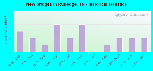
- New bridges - historical statistics
- 31920-1929
- 21930-1939
- 11940-1949
- 41950-1959
- 21960-1969
- 41970-1979
- 11990-1999
- 22000-2009
- 22010-2019
- 22020-2022
FCC Registered Cell Phone Towers:
1 (See the full list of FCC Registered Cell Phone Towers in Rutledge)FCC Registered Antenna Towers:
55 (See the full list of FCC Registered Antenna Towers)FCC Registered Broadcast Land Mobile Towers:
5- 270 Justice Center Drive (Lat: 36.283889 Lon: -83.510000), Type: Gtower, Structure height: 30 m, Overall height: 37 m, Call Sign: WPRH893,
Assigned Frequencies: 155.295 MHz, 155.205 MHz, 155.340 MHz, Grant Date: 07/11/2015, Expiration Date: 09/27/2025, Certifier: Randy Holt, Registrant: Metro Communications LLC, 1210 Elm Street, Knoxville, TN 37921, Phone: (865) 546-0311, Fax: (865) 546-8666, Email:
- Lat: 36.283889 Lon: -83.515833, Structure height: 0 m, Call Sign: WPXQ690,
Assigned Frequencies: 461.412 MHz, 461.387 MHz, 461.487 MHz, 461.662 MHz, 461.587 MHz, Grant Date: 03/02/2013, Expiration Date: 05/21/2023, Cancellation Date: 07/22/2023, Certifier: Terry Acuff, Registrant: Metro Communications LLC, 1210 Elm Street, Knoxville, TN 37921, Phone: (865) 546-0311, Fax: (865) 546-8666, Email:
- Justice Center Dr (Lat: 36.284417 Lon: -83.510028), Type: Building, Structure height: 6 m, Overall height: 8 m, Call Sign: WQFV485,
Assigned Frequencies: 460.062 MHz, Grant Date: 08/12/2016, Expiration Date: 10/13/2026, Certifier: Randy Holt, Registrant: Metro Communications LLC, 1210 Elm Street, Knoxville, TN 37921, Phone: (865) 546-0311, Fax: (865) 546-8666, Email:
- W HILLS WATER TANK, 224 West Hills Road (Lat: 36.281222 Lon: -83.547222), Type: Tank, Structure height: 2.4 m, Overall height: 9.1 m, Call Sign: WQGX261, Licensee ID: L01248150,
Assigned Frequencies: 154.463 MHz, Grant Date: 03/16/2017, Expiration Date: 05/11/2027, Certifier: Jeff Moyers, Registrant: Rutledge, Town Of, 8028 Rutledge Pike, Rutledge, TN 37861, Phone: (865) 828-4513, Fax: (865) 828-8493
- WEST TANK, Tank @ End Of W Hills Rd (Lat: 36.275639 Lon: -83.548139), Type: Pipe, Structure height: 6.1 m, Call Sign: WQTY624,
Assigned Frequencies: 173.203 MHz, Grant Date: 05/07/2014, Expiration Date: 05/07/2024, Certifier: Jeff W Moyers, Registrant: Dexter Fortson Associates, Inc, 5511 Powder Plant Ln, Bessemer, AL 35022, Phone: (205) 432-2700, Fax: (205) 491-4751
FCC Registered Microwave Towers:
5- RUTLEDGE, 2.8 Miles West Of (Lat: 36.276111 Lon: -83.563889), Type: Ltower, Structure height: 54.9 m, Overall height: 59.4 m, Call Sign: WQPL474,
Assigned Frequencies: 6197.24 MHz, 6256.54 MHz, Grant Date: 05/17/2022, Expiration Date: 06/20/2032, Cancellation Date: 03/09/2023, Certifier: Gregory M Romano, Registrant: Verizon, 5055 Northpointe Pkwy, Alpharetta, GA 30022, Phone: (770) 797-1070, Email:
- COMBS KNOB, Route 1 Box 155-1a (Lat: 36.186639 Lon: -83.508500), Type: Ltower, Structure height: 91.4 m, Overall height: 93.9 m, Call Sign: WQTC629,
Assigned Frequencies: 11225.0 MHz, 11265.0 MHz, 11305.0 MHz, 11345.0 MHz, Grant Date: 12/05/2023, Expiration Date: 01/07/2034, Certifier: John E Monday, Registrant: At&t Services, Inc., 208 S Akard St, 20f, Dallas, TX 75202, Phone: (855) 699-7073, Email:
- 9KX0051A, Rt 1 Box 63 (#29004) (Lat: 36.238472 Lon: -83.523722), Type: Ltower, Structure height: 91.7 m, Overall height: 94.2 m, Call Sign: WQWB528,
Assigned Frequencies: 11325.0 MHz, 11405.0 MHz, 11325.0 MHz, 11405.0 MHz, 11325.0 MHz, 11405.0 MHz, 11325.0 MHz, 11405.0 MHz, 11325.0 MHz, 11405.0 MHz... (+20 more), Grant Date: 07/09/2015, Expiration Date: 07/09/2025, Certifier: David Werblow, Registrant: T-Mobile Usa, Inc., 12920 Se 38th Street, Bellevue, WA 98006, Phone: (425) 383-8401, Fax: (425) 383-4040, Email:
- 9KX0046A, West Hills Road (Lat: 36.275278 Lon: -83.548056), Type: Ltower, Structure height: 88.4 m, Call Sign: WQWC888,
Assigned Frequencies: 10855.0 MHz, 10855.0 MHz, 10855.0 MHz, 10855.0 MHz, 10855.0 MHz, 10855.0 MHz, 10855.0 MHz, 10855.0 MHz, 10995.0 MHz, 11075.0 MHz... (+20 more), Grant Date: 07/21/2015, Expiration Date: 07/21/2025, Certifier: David Werblow, Registrant: T-Mobile Usa, Inc., 12920 Se 38th Street, Bellevue, WA 98006, Phone: (425) 383-8401, Fax: (425) 383-4040, Email:
- 9KX0047A, Rt. 2, Box 345 (Robbins Rd) (Lat: 36.315056 Lon: -83.446028), Type: Ltower, Structure height: 85.6 m, Call Sign: WQWC947,
Assigned Frequencies: 11245.0 MHz, 11325.0 MHz, 11245.0 MHz, 11325.0 MHz, 11245.0 MHz, 11325.0 MHz, 11245.0 MHz, 11325.0 MHz, 11245.0 MHz, 11325.0 MHz... (+20 more), Grant Date: 07/21/2015, Expiration Date: 07/21/2025, Certifier: David Werblow, Registrant: T-Mobile Usa, Inc., 12920 Se 38th Street, Bellevue, WA 98006, Phone: (425) 383-8401, Fax: (425) 383-4040, Email:
FCC Registered Amateur Radio Licenses:
57 (See the full list of FCC Registered Amateur Radio Licenses in Rutledge)FAA Registered Aircraft Manufacturers and Dealers:
1 (See the full list of FAA Registered Manufacturers and Dealers in Rutledge)FAA Registered Aircraft:
10 (See the full list of FAA Registered Aircraft)2002 - 2018 National Fire Incident Reporting System (NFIRS) incidents
- Fire incident types reported to NFIRS in Rutledge, TN
- 13844.4%Outside Fires
- 12239.2%Structure Fires
- 4414.1%Mobile Property/Vehicle Fires
- 72.3%Other
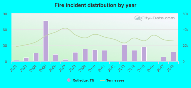 Based on the data from the years 2002 - 2018 the average number of fire incidents per year is 18. The highest number of reported fire incidents - 77 took place in 2005, and the least - 0 in 2012. The data has a growing trend.
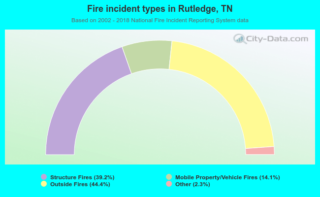 When looking into fire subcategories, the most reports belonged to: Outside Fires (44.4%), and Structure Fires (39.2%).
| Most common first names in Rutledge, TN among deceased individuals | ||
| Name | Count | Lived (average) |
|---|---|---|
| James | 97 | 72.1 years |
| Mary | 57 | 77.3 years |
| John | 56 | 76.0 years |
| William | 52 | 74.7 years |
| George | 37 | 72.8 years |
| Robert | 36 | 70.1 years |
| Edith | 20 | 79.9 years |
| Helen | 19 | 78.4 years |
| Edna | 17 | 80.8 years |
| Joseph | 16 | 73.9 years |
| Most common last names in Rutledge, TN among deceased individuals | ||
| Last name | Count | Lived (average) |
|---|---|---|
| Morgan | 64 | 74.4 years |
| Roach | 58 | 79.8 years |
| Hodge | 43 | 76.6 years |
| Cameron | 40 | 74.1 years |
| Dalton | 40 | 76.6 years |
| Williams | 39 | 76.1 years |
| Jones | 35 | 75.7 years |
| Collins | 32 | 73.2 years |
| Greenlee | 30 | 77.1 years |
| Hixon | 29 | 72.8 years |
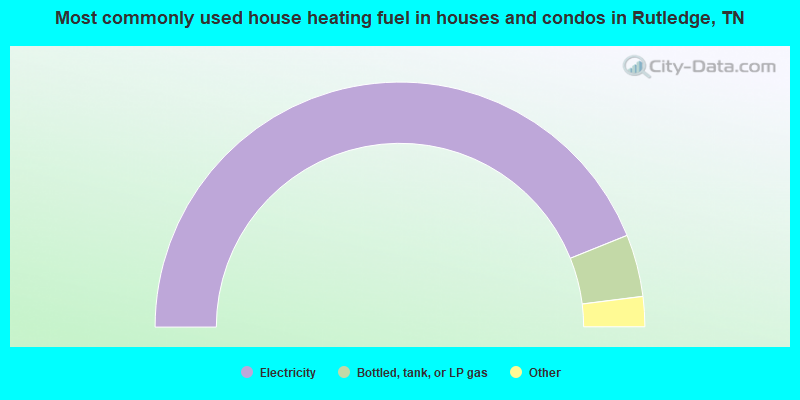
- 88.0%Electricity
- 8.2%Bottled, tank, or LP gas
- 2.7%Utility gas
- 1.0%Wood
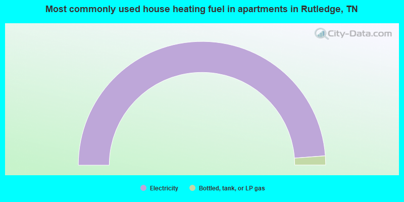
- 97.6%Electricity
- 2.4%Bottled, tank, or LP gas
Rutledge compared to Tennessee state average:
- Median household income below state average.
- Median house value below state average.
- Unemployed percentage below state average.
- Black race population percentage significantly below state average.
- Median age above state average.
- Length of stay since moving in significantly above state average.
- Number of rooms per house below state average.
- Institutionalized population percentage significantly above state average.
- Number of college students below state average.
- Percentage of population with a bachelor's degree or higher below state average.
Rutledge on our top lists:
- #58 on the list of "Top 101 cities with the largest percentage of people in nursing homes (population 1,000+)"
- #25 on the list of "Top 101 counties with the lowest total withdrawal of fresh water for public supply"
- #79 on the list of "Top 101 counties with the lowest ground withdrawal of fresh water for public supply"

|
Total of 2 patent applications in 2008-2024.