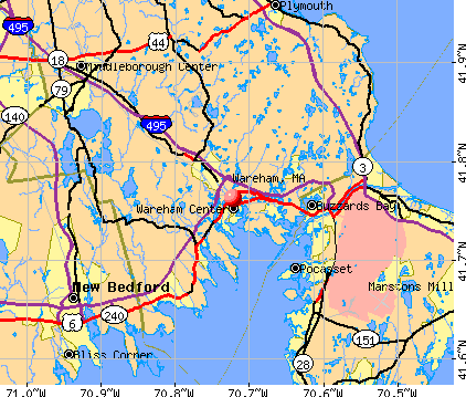
Wareham, Massachusetts
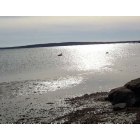
Wareham: little harbor Beach

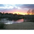
Wareham: The Weweantic River 7th ave beach
Wareham: Shangri La
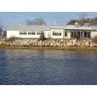
Wareham: Wareham River narrows Resraunt
- add
your


Submit your own pictures of this town and show them to the world
- OSM Map
- General Map
- Google Map
- MSN Map
Population change since 2000: +7.3%
 |
| Males: 10,498 | |
| Females: 11,324 |
| Median resident age: | 44.4 years |
| Massachusetts median age: | 39.2 years |
Zip codes: 02571.
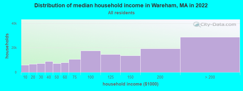
| Wareham: | $74,988 |
| MA: | $94,488 |
Estimated per capita income in 2022: $46,566 (it was $21,312 in 2000)
Wareham town income, earnings, and wages data
Estimated median house or condo value in 2022: $363,743 (it was $116,800 in 2000)
| Wareham: | $363,743 |
| MA: | $534,700 |
Mean prices in 2022: all housing units: $585,203; detached houses: $620,100; townhouses or other attached units: $487,972; in 2-unit structures: $464,355; in 3-to-4-unit structures: $429,583; in 5-or-more-unit structures: $438,441; mobile homes: $207,706; occupied boats, rvs, vans, etc.: $17,153
Detailed information about poverty and poor residents in Wareham, MA


Compare current foreclosures near Wareham, MA:
| Photo | Address | Area | Beds / Baths | Price | Details |
|---|---|---|---|---|---|

|
#1
Main St
Wareham, MA 02571
|
1,389 sq. feet
|
1 baths 3 beds |
show details | |

|
#2
Daniel Rd
Wareham, MA 02571
|
1,316 sq. feet
|
1 baths 3 beds |
show details | |

|
#3
7th Ave
Wareham, MA 02571
|
1,175 sq. feet
|
1 baths 3 beds |
show details | |

|
#4
Tarpaulin Way
Wareham, MA 02571
|
1,306 sq. feet
|
2 baths 3 beds |
show details | |

|
#5
14th Ave
Wareham, MA 02571
|
936 sq. feet
|
1 baths 2 beds |
show details | |

|
#6
Minot Ave
Wareham, MA 02571
|
960 sq. feet
|
1 baths 3 beds |
show details | |

|
#7
Forest Way
Wareham, MA 02571
|
2,969 sq. feet
|
2 baths 4 beds |
show details | |

|
#8
Cranberry Hwy
Wareham, MA 02571
|
979 sq. feet
|
1 baths 3 beds |
show details | |

|
#9
Burgee Ln
Wareham, MA 02571
|
1,466 sq. feet
|
2 baths 3 beds |
show details | |

|
#10
Main St
Wareham, MA 02571
|
2,324 sq. feet
|
1 baths 4 beds |
show details |
| Photo | Address | Area | Beds / Baths | Price | Details |
|---|---|---|---|---|---|

|
#11
Terry Ln E
Wareham, MA 02571
|
1,412 sq. feet
|
1 baths 3 beds |
show details | |

|
#12
Swifts Beach Rd
Wareham, MA 02571
|
1,180 sq. feet
|
1 baths 3 beds |
show details | |

|
#13
Parkwood Dr
Wareham, MA 02571
|
- sq. feet
|
- baths - beds |
show details | |

|
#14
Wankinquoah Ave
Wareham, MA 02571
|
- sq. feet
|
- baths - beds |
show details | |

|
#15
Cleveland Way
Wareham, MA 02571
|
- sq. feet
|
- baths - beds |
show details | |

|
#16
Swifts Beach Rd
Wareham, MA 02571
|
- sq. feet
|
- baths - beds |
show details | |

|
#17
Old Beaver Dam Rd
Wareham, MA 02571
|
- sq. feet
|
- baths - beds |
show details | |

|
#18
Parkwood Dr
Wareham, MA 02571
|
- sq. feet
|
- baths - beds |
show details | |

|
#19
W Falmouth Hwy
Falmouth, MA 02540
|
1,224 sq. feet
|
2 baths 4 beds |
$695,000
|
show details |

|
#20
Peckham St
New Bedford, MA 02746
|
3,089 sq. feet
|
3 baths 9 beds |
show details |
| Photo | Address | Area | Beds / Baths | Price | Details |
|---|---|---|---|---|---|

|
#21
Braley Rd
East Freetown, MA 02717
|
819 sq. feet
|
1 baths 2 beds |
show details | |

|
#22
Holly Cir # 16a
Buzzards Bay, MA 02532
|
1,451 sq. feet
|
2 baths 3 beds |
show details | |

|
#23
Tananger Rd
Plymouth, MA 02360
|
1,836 sq. feet
|
3 baths 3 beds |
show details | |

|
#24
Ivy Ln
Lakeville, MA 02347
|
496 sq. feet
|
1 baths 1 beds |
show details | |

|
#25
N Main St
Middleboro, MA 02346
|
1,898 sq. feet
|
2 baths 4 beds |
show details | |

|
#26
Bridge St
Fairhaven, MA 02719
|
1,644 sq. feet
|
3 baths 3 beds |
show details | |

|
#27
Orchard Rd
Mashpee, MA 02649
|
1,488 sq. feet
|
2 baths 4 beds |
show details | |

|
#28
-75 Fairhaven Road
Mattapoisett, MA 02739
|
1,200 sq. feet
|
1 baths 3 beds |
show details | |

|
#29
Chickadee Ln
Plymouth, MA 02360
|
1,008 sq. feet
|
1 baths 2 beds |
show details | |

|
#30
State Rd
Plymouth, MA 02360
|
1,836 sq. feet
|
2 baths 2 beds |
show details |
| Photo | Address | Area | Beds / Baths | Price | Details |
|---|---|---|---|---|---|

|
#31
Erin Ct
New Bedford, MA 02745
|
1,814 sq. feet
|
2 baths 3 beds |
show details | |

|
#32
Mill St
New Bedford, MA 02740
|
1,542 sq. feet
|
1 baths 3 beds |
show details | |

|
#33
Dartmouth St
New Bedford, MA 02740
|
2,724 sq. feet
|
3 baths 5 beds |
show details | |

|
#34
Homestead Ave
Acushnet, MA 02743
|
936 sq. feet
|
1 baths 3 beds |
show details | |

|
#35
Saint John St
South Dartmouth, MA 02748
|
1,182 sq. feet
|
2 baths 3 beds |
show details | |

|
#36
Knowlton Ln
Marstons Mills, MA 02648
|
1,888 sq. feet
|
2 baths 3 beds |
show details | |

|
#37
Holly Tree Ln
New Bedford, MA 02745
|
1,025 sq. feet
|
2 baths 3 beds |
show details | |

|
#38
Hedge St
Fairhaven, MA 02719
|
878 sq. feet
|
1 baths 2 beds |
show details | |

|
#39
Alfred St
New Bedford, MA 02745
|
2,016 sq. feet
|
2 baths 5 beds |
show details | |

|
#40
Court St # 1
Plymouth, MA 02360
|
2,542 sq. feet
|
3 baths 5 beds |
show details |
| Photo | Address | Area | Beds / Baths | Price | Details |
|---|---|---|---|---|---|

|
#41
Sunset Strip
Mashpee, MA 02649
|
1,428 sq. feet
|
1 baths 2 beds |
show details | |

|
#42
Main St
Fairhaven, MA 02719
|
2,412 sq. feet
|
2 baths 4 beds |
show details | |

|
#43
Jarry St
New Bedford, MA 02745
|
840 sq. feet
|
1 baths 2 beds |
show details | |

|
#44
Lark St
New Bedford, MA 02745
|
1,274 sq. feet
|
1 baths 3 beds |
show details | |

|
#45
Main St
Mashpee, MA 02649
|
1,430 sq. feet
|
2 baths 3 beds |
show details | |

|
#46
Winterville Rd
New Bedford, MA 02740
|
993 sq. feet
|
1 baths 3 beds |
show details | |

|
#47
Wilbur Ave
North Dartmouth, MA 02747
|
1,218 sq. feet
|
1 baths 3 beds |
show details | |

|
#48
Wapping Rd
Kingston, MA 02364
|
1,904 sq. feet
|
2 baths 3 beds |
show details | |

|
#49
Spring St
Plympton, MA 02367
|
1,700 sq. feet
|
1 baths 4 beds |
show details | |

|
Check over 1 million property listings on Foreclosure.com!
|
browse all offers | |||

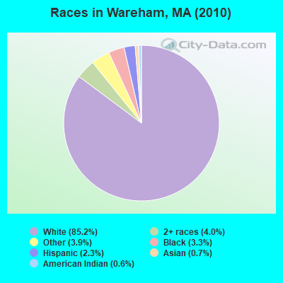
- 18,59485.2%White alone
- 8714.0%Two or more races
- 8503.9%Other race alone
- 7283.3%Black alone
- 5022.3%Hispanic
- 1470.7%Asian alone
- 1250.6%American Indian alone
- 50.02%Native Hawaiian and Other
Pacific Islander alone
Races in Wareham detailed stats: ancestries, foreign born residents, place of birth
According to our research of Massachusetts and other state lists, there were 22 registered sex offenders living in Wareham, Massachusetts as of April 26, 2024.
The ratio of all residents to sex offenders in Wareham is 992 to 1.
Type |
2009 |
2010 |
2011 |
2012 |
2013 |
2014 |
2015 |
2016 |
2017 |
2018 |
2019 |
2020 |
2021 |
2022 |
|---|---|---|---|---|---|---|---|---|---|---|---|---|---|---|
| Murders (per 100,000) | 1 (4.7) | 0 (0.0) | 2 (9.1) | 1 (4.5) | 0 (0.0) | 0 (0.0) | 0 (0.0) | 0 (0.0) | 0 (0.0) | 0 (0.0) | 1 (4.4) | 1 (4.2) | 0 (0.0) | 1 (4.1) |
| Rapes (per 100,000) | 12 (56.0) | 7 (32.1) | 4 (18.2) | 15 (67.8) | 20 (88.6) | 13 (57.6) | 10 (44.2) | 11 (49.1) | 9 (39.6) | 17 (74.7) | 23 (101.8) | 13 (55.0) | 11 (45.9) | 12 (49.2) |
| Robberies (per 100,000) | 30 (140.0) | 21 (96.2) | 13 (59.2) | 26 (117.5) | 21 (93.1) | 12 (53.1) | 13 (57.4) | 15 (66.9) | 6 (26.4) | 15 (65.9) | 9 (39.8) | 3 (12.7) | 3 (12.5) | 8 (32.8) |
| Assaults (per 100,000) | 103 (480.6) | 138 (632.4) | 111 (505.6) | 112 (506.0) | 122 (540.6) | 93 (411.8) | 88 (388.7) | 97 (432.6) | 114 (501.3) | 128 (562.7) | 128 (566.6) | 72 (304.8) | 60 (250.5) | 55 (225.5) |
| Burglaries (per 100,000) | 212 (989.2) | 174 (797.4) | 264 (1,202) | 281 (1,269) | 222 (983.7) | 172 (761.6) | 113 (499.1) | 90 (401.4) | 75 (329.8) | 57 (250.6) | 51 (225.7) | 49 (207.5) | 32 (133.6) | 35 (143.5) |
| Thefts (per 100,000) | 432 (2,016) | 514 (2,355) | 551 (2,510) | 647 (2,923) | 554 (2,455) | 484 (2,143) | 366 (1,617) | 329 (1,467) | 326 (1,433) | 299 (1,314) | 251 (1,111) | 166 (702.8) | 166 (692.9) | 189 (774.9) |
| Auto thefts (per 100,000) | 37 (172.6) | 40 (183.3) | 29 (132.1) | 22 (99.4) | 30 (132.9) | 28 (124.0) | 26 (114.8) | 26 (116.0) | 24 (105.5) | 28 (123.1) | 20 (88.5) | 16 (67.7) | 27 (112.7) | 19 (77.9) |
| Arson (per 100,000) | 4 (18.7) | 6 (27.5) | 8 (36.4) | 7 (31.6) | 12 (53.2) | 4 (17.7) | 7 (30.9) | 4 (17.8) | 2 (8.8) | 2 (8.8) | 0 (0.0) | 1 (4.2) | 2 (8.3) | 0 (0.0) |
| City-Data.com crime index | 355.9 | 345.7 | 346.8 | 413.4 | 384.6 | 293.3 | 239.1 | 241.9 | 228.7 | 272.1 | 282.9 | 165.3 | 136.7 | 149.8 |
The City-Data.com crime index weighs serious crimes and violent crimes more heavily. Higher means more crime, U.S. average is 246.1. It adjusts for the number of visitors and daily workers commuting into cities.
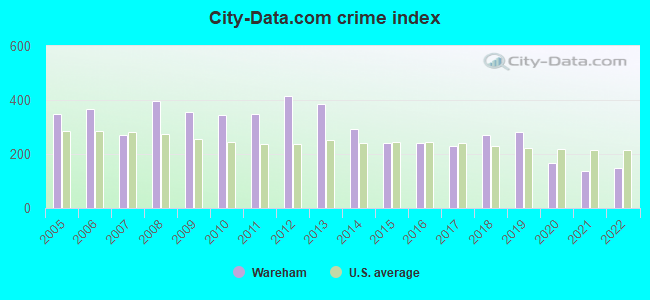
Crime rate in Wareham detailed stats: murders, rapes, robberies, assaults, burglaries, thefts, arson
Full-time law enforcement employees in 2021, including police officers: 55 (45 officers - 42 male; 3 female).
| Officers per 1,000 residents here: | 1.88 |
| Massachusetts average: | 2.53 |
 Recent articles from our blog. Our writers, many of them Ph.D. graduates or candidates, create easy-to-read articles on a wide variety of topics.


 | "Migrants" living in hotels in MA---What is the endgame or is there one at all? (986 replies) |
| Big MA Ancestry Data Thread by Town (31 replies) |
| Coronavirus in Massachusetts (18047 replies) |
| Best coastal town in Mass for young retirees (106 replies) |
| Retirement in MA? (81 replies) |
| The different parts of Wareham (16 replies) |
Latest news from Wareham, MA collected exclusively by city-data.com from local newspapers, TV, and radio stations
Ancestries: Irish (22.4%), English (16.0%), Italian (12.5%), Portuguese (9.0%), French (8.6%), Subsaharan African (7.7%).
Current Local Time: EST time zone
Incorporated in 1739
Elevation: 20 feet
Land area: 35.8 square miles.
Population density: 610 people per square mile (low).
707 residents are foreign born (1.8% Europe, 0.7% Africa, 0.6% North America).
| This town: | 3.5% |
| Massachusetts: | 12.2% |
| Wareham town: | 1.4% ($1,647) |
| Massachusetts: | 1.3% ($2,336) |
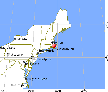
Nearest city with pop. 50,000+: New Bedford, MA  (14.8 miles , pop. 93,768).
Nearest city with pop. 200,000+: Boston, MA (43.9 miles , pop. 589,141).
Nearest city with pop. 1,000,000+: Bronx, NY (177.2 miles , pop. 1,332,650).
Nearest cities:
), ), ), Latitude: 41.76 N, Longitude: 70.69 W
Area code: 508

Wareham tourist attractions:
Wareham, Massachusetts accommodation & food services, waste management - Economy and Business Data
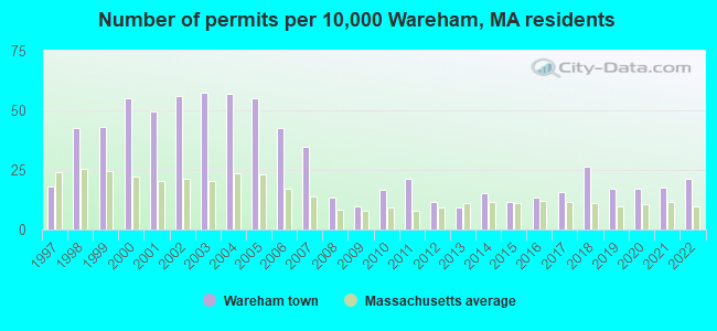
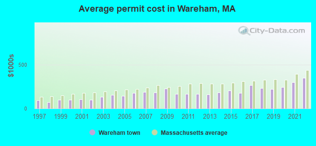
Single-family new house construction building permits:
- 2022: 43 buildings, average cost: $346,700
- 2021: 36 buildings, average cost: $297,600
- 2020: 35 buildings, average cost: $244,700
- 2019: 35 buildings, average cost: $219,200
- 2018: 54 buildings, average cost: $231,600
- 2017: 32 buildings, average cost: $263,800
- 2016: 27 buildings, average cost: $178,300
- 2015: 24 buildings, average cost: $201,500
- 2014: 31 buildings, average cost: $181,800
- 2013: 19 buildings, average cost: $157,600
- 2012: 24 buildings, average cost: $167,400
- 2011: 43 buildings, average cost: $164,900
- 2010: 34 buildings, average cost: $165,300
- 2009: 20 buildings, average cost: $225,000
- 2008: 27 buildings, average cost: $181,200
- 2007: 71 buildings, average cost: $187,200
- 2006: 87 buildings, average cost: $179,100
- 2005: 112 buildings, average cost: $144,500
- 2004: 116 buildings, average cost: $155,200
- 2003: 117 buildings, average cost: $134,800
- 2002: 114 buildings, average cost: $100,300
- 2001: 101 buildings, average cost: $105,000
- 2000: 112 buildings, average cost: $99,500
- 1999: 88 buildings, average cost: $99,100
- 1998: 87 buildings, average cost: $71,800
- 1997: 37 buildings, average cost: $92,900
| Here: | 3.9% |
| Massachusetts: | 3.5% |
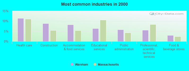
- Health care (11.4%)
- Construction (8.8%)
- Accommodation & food services (8.3%)
- Educational services (6.4%)
- Public administration (5.8%)
- Professional, scientific, technical services (5.6%)
- Food & beverage stores (3.1%)
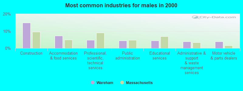
- Construction (14.9%)
- Accommodation & food services (7.3%)
- Professional, scientific, technical services (4.7%)
- Public administration (4.5%)
- Educational services (4.5%)
- Administrative & support & waste management services (4.0%)
- Motor vehicle & parts dealers (3.9%)
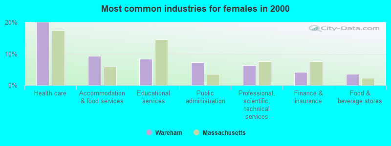
- Health care (19.9%)
- Accommodation & food services (9.3%)
- Educational services (8.4%)
- Public administration (7.2%)
- Professional, scientific, technical services (6.4%)
- Finance & insurance (4.2%)
- Food & beverage stores (3.5%)
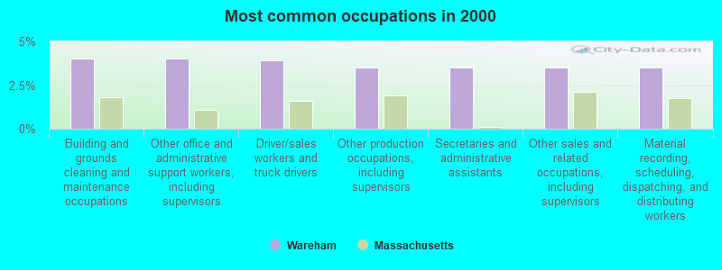
- Building and grounds cleaning and maintenance occupations (4.0%)
- Other office and administrative support workers, including supervisors (4.0%)
- Driver/sales workers and truck drivers (3.9%)
- Other production occupations, including supervisors (3.5%)
- Secretaries and administrative assistants (3.5%)
- Other sales and related occupations, including supervisors (3.5%)
- Material recording, scheduling, dispatching, and distributing workers (3.5%)
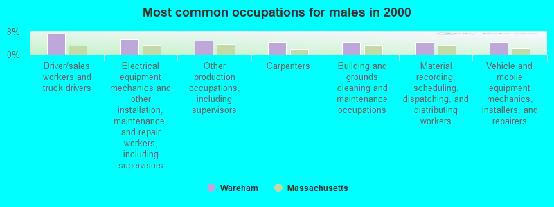
- Driver/sales workers and truck drivers (7.2%)
- Electrical equipment mechanics and other installation, maintenance, and repair workers, including supervisors (5.2%)
- Other production occupations, including supervisors (5.0%)
- Carpenters (4.4%)
- Building and grounds cleaning and maintenance occupations (4.4%)
- Material recording, scheduling, dispatching, and distributing workers (4.3%)
- Vehicle and mobile equipment mechanics, installers, and repairers (4.3%)
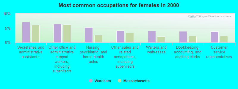
- Secretaries and administrative assistants (7.1%)
- Other office and administrative support workers, including supervisors (6.3%)
- Nursing, psychiatric, and home health aides (5.3%)
- Other sales and related occupations, including supervisors (4.1%)
- Waiters and waitresses (4.1%)
- Bookkeeping, accounting, and auditing clerks (3.9%)
- Customer service representatives (3.8%)
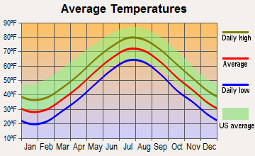
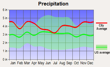
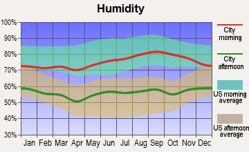
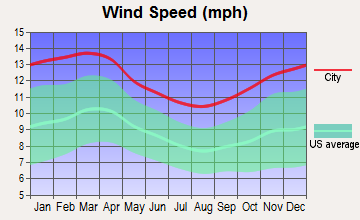
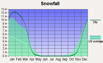
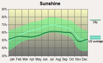
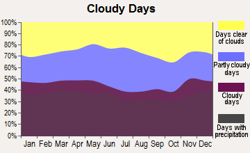
Average climate in Wareham, Massachusetts
Based on data reported by over 4,000 weather stations
(lower is better)
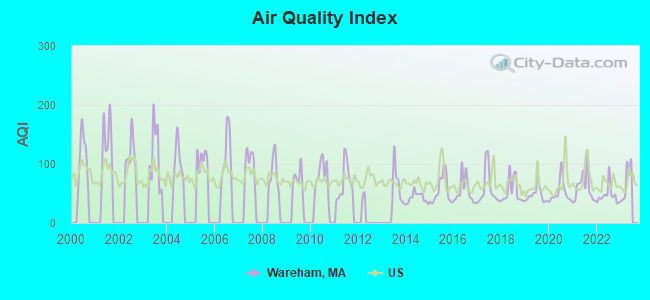
Air Quality Index (AQI) level in 2022 was 46.8. This is significantly better than average.
| City: | 46.8 |
| U.S.: | 72.6 |
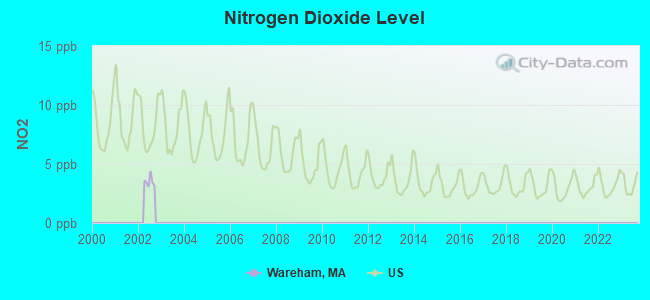
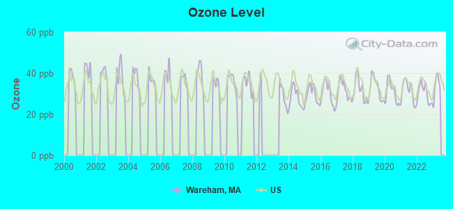
Ozone [ppb] level in 2022 was 30.2. This is about average. Closest monitor was 13.3 miles away from the city center.
| City: | 30.2 |
| U.S.: | 33.3 |
Tornado activity:
Wareham-area historical tornado activity is significantly below Massachusetts state average. It is 75% smaller than the overall U.S. average.
On 6/9/1953, a category F3 (max. wind speeds 158-206 mph) tornado 33.1 miles away from the Wareham town center injured 17 people and caused between $500,000 and $5,000,000 in damages.
On 6/9/1953, a category F4 (max. wind speeds 207-260 mph) tornado 56.8 miles away from the town center killed 90 people and injured 1228 people and caused between $50,000,000 and $500,000,000 in damages.
Earthquake activity:
Wareham-area historical earthquake activity is significantly above Massachusetts state average. It is 76% smaller than the overall U.S. average.On 10/7/1983 at 10:18:46, a magnitude 5.3 (5.1 MB, 5.3 LG, 5.1 ML, Class: Moderate, Intensity: VI - VII) earthquake occurred 239.4 miles away from Wareham center
On 4/20/2002 at 10:50:47, a magnitude 5.3 (5.3 ML, Depth: 3.0 mi) earthquake occurred 243.5 miles away from Wareham center
On 10/16/2012 at 23:12:25, a magnitude 4.7 (4.7 ML, Depth: 10.0 mi, Class: Light, Intensity: IV - V) earthquake occurred 127.0 miles away from the city center
On 1/19/1982 at 00:14:42, a magnitude 4.7 (4.5 MB, 4.7 MD, 4.5 LG) earthquake occurred 128.9 miles away from the city center
On 4/20/2002 at 10:50:47, a magnitude 5.2 (5.2 MB, 4.2 MS, 5.2 MW, 5.0 MW) earthquake occurred 242.8 miles away from the city center
On 8/22/1992 at 12:20:32, a magnitude 4.8 (4.8 MB, 3.8 MS, 4.7 LG, Depth: 6.2 mi) earthquake occurred 184.6 miles away from the city center
Magnitude types: regional Lg-wave magnitude (LG), body-wave magnitude (MB), duration magnitude (MD), local magnitude (ML), surface-wave magnitude (MS), moment magnitude (MW)
Natural disasters:
The number of natural disasters in Plymouth County (26) is a lot greater than the US average (15).Major Disasters (Presidential) Declared: 17
Emergencies Declared: 9
Causes of natural disasters: Floods: 11, Storms: 9, Hurricanes: 7, Snows: 3, Snowstorms: 3, Blizzards: 2, Winter Storms: 2, Heavy Rain: 1, Snowfall: 1, Tropical Storm: 1, Wind: 1 (Note: some incidents may be assigned to more than one category).
Hospitals and medical centers in Wareham:
- HOSPICE SERVICES OF MASSACHUSETTS (577 MAIN STREET)
- LIGHTHOUSE HOSPICE ASSOCIATION, INC (166 MAIN STREET, P O BOX 448)
- KINDRED TRANSITIONAL CARE AND REHABILITA-FORESTVIEW (50 INDIAN NECK ROAD)
- ROLAND THATCHER NURSING HOME (MAIN ST)
- TCU-TOBEY HOSPITAL (43 HIGH STREET)
- TREMONT HEALTH CARE CENTER (605 MAIN STREET)
Airports and heliports located in Wareham:
See details about Airports and heliports located in Wareham, MAOperable nuclear power plant near Wareham:
- 14 miles: Pilgrim in Plymouth, MA.
Colleges/universities with over 2000 students nearest to Wareham:
- Cape Cod Community College (about 19 miles; West Barnstable, MA; Full-time enrollment: 2,491)
- University of Massachusetts-Dartmouth (about 19 miles; North Dartmouth, MA; FT enrollment: 7,545)
- Bridgewater State University (about 22 miles; Bridgewater, MA; FT enrollment: 9,802)
- Bristol Community College (about 23 miles; Fall River, MA; FT enrollment: 5,707)
- Massasoit Community College (about 27 miles; Brockton, MA; FT enrollment: 5,442)
- Stonehill College (about 29 miles; Easton, MA; FT enrollment: 2,563)
- Roger Williams University (about 31 miles; Bristol, RI; FT enrollment: 4,375)
Library in Wareham:
- WAREHAM FREE LIBRARY (Operating income: $661,301; Location: 59 MARION ROAD; 96,223 books; 523 e-books; 4,727 audio materials; 3,818 video materials; 5 local licensed databases; 34 state licensed databases; 1 other licensed databases; 122 print serial subscriptions; 2 electronic serial subscriptions)
User-submitted facts and corrections:
- Tobey Hospital is a full service hospital, located on High Street in Wareham Center. They are part of Southcoast facilities serving Southeastern Massachusetts.
Points of interest:
Notable locations in Wareham: Cranberry Plaza (A), Little Harbor Golf Course (B), Onset Town Wharf (C), Point Independence Yacht Club (D), Wareham Country Club (E), Wareham Emergency Medical Services (F), Wareham Fire Department Station 2 (G), Wareham Fire Department Station 4 (H), Wareham Fire Department Station 3 (I), Onset Fire Station 2 (J), Wareham Fire Department Station 1 Headquarters (K), Onset Fire Department Station 1 Headquarters (L), John William Decas School Library Media Center (M), Kendrick House Museum (N), Stillman Library (O), Wareham Town Hall (P), Fearing Tavern (Q). Display/hide their locations on the map
Shopping Center: Cranberry Plaza Shopping Center (1). Display/hide its location on the map
Churches in Wareham include: Wesley United Methodist Church (A), Tabernacle of Praise Church (B), South Shore Community Church (C), Saint Patricks Church (D), Hebron Tabernacle Church (E), First Congregational Church (F), Feed My Lambs Fellowship Church (G), Church of the Nazarene (H), Church of the Good Shepherd (I). Display/hide their locations on the map
Cemeteries: Centre Cemetery (1), Saint Patricks Cemetery (2), Long Neck Cemetery (3), Agawam Cemetery (4). Display/hide their locations on the map
Lakes, reservoirs, and swamps: Mosquito Pond (A), Dicks Pond (B), Cedar Ponds (C), Cedar Pond (D), Bartlett Pond (E), Black Jonny Pond (F), Popes Pond (G), Beaver Dam Pond (H). Display/hide their locations on the map
Streams, rivers, and creeks: Rose Brook (A), Red Brook (B), Agawam River (C), Stony Run (D), Maple Springs Brook (E), Gibbs Brook (F), Wankinco River (G), Cohackett Brook (H), Beaverdam Creek (I). Display/hide their locations on the map
Beaches: Little Harbor Beach (A), Indian Mound Beach (B), Parkwood Beach (C), Minot Forest Beach (D). Display/hide their locations on the map
Tourist attraction: Captain John Kendrick Maritme Museum Curator's OFC (102 Main Street) (1). Display/hide its approximate location on the map
Hotels: Briarwood Beach Motel (Route 6) (1), Bridge View Hotel (4 South Water) (2), Silver Lake Motel (3026 Cranbrry Highway Rou) (3). Display/hide their approximate locations on the map
Court: Massachusetts Commonwealth - Trial Court- Superior Court Dept- Wareham District C (2200 Cranberry Highway) (1). Display/hide its approximate location on the map
Birthplace of: Geena Davis - (born 1956), actress, Pebbles (radio personality) - Radio personality, Samuel T. Wellman - Businessman, Skipp Sudduth - Film actor, Stephen Cooper - 2005 NFL player (San Diego Chargers, born: Jun 19, 1979), Brandon Westgate - Skateboarder.
Drinking water stations with addresses in Wareham and their reported violations in the past:
WAREHAM FIRE DISTRICT (Population served: 20,283, Groundwater):Past health violations:
- MCL, Monthly (TCR) - In OCT-2011, Contaminant: Coliform. Follow-up actions: St AO (w/o penalty) issued (JAN-31-2012), St Compliance achieved (JAN-31-2012)
- MCL, Acute (TCR) - In SEP-2009, Contaminant: Coliform. Follow-up actions: St AO (w/o penalty) issued (NOV-30-2009)
- MCL, Monthly (TCR) - In SEP-2009, Contaminant: Coliform. Follow-up actions: St AO (w/o penalty) issued (NOV-30-2009)
- MCL, Monthly (TCR) - In JAN-2009, Contaminant: Coliform. Follow-up actions: St AO (w/o penalty) issued (JUN-09-2009), St Compliance achieved (JUN-09-2009)
- MCL, Monthly (TCR) - In AUG-2008, Contaminant: Coliform. Follow-up actions: St AO (w/o penalty) issued (AUG-22-2008)
- MCL, Acute (TCR) - In AUG-2008, Contaminant: Coliform. Follow-up actions: St AO (w/o penalty) issued (AUG-22-2008)
- 3 other older health violations
| This town: | 2.4 people |
| Massachusetts: | 2.5 people |
| This town: | 63.5% |
| Whole state: | 63.0% |
| This town: | 8.7% |
| Whole state: | 7.0% |
Likely homosexual households (counted as self-reported same-sex unmarried-partner households)
- Lesbian couples: 0.6% of all households
- Gay men: 0.3% of all households
| This town: | 10.7% |
| Whole state: | 9.3% |
| This town: | 3.9% |
| Whole state: | 4.4% |
People in group quarters in Wareham in 2010:
- 170 people in nursing facilities/skilled-nursing facilities
- 40 people in group homes intended for adults
- 10 people in group homes for juveniles (non-correctional)
- 7 people in residential treatment centers for adults
- 3 people in other noninstitutional facilities
People in group quarters in Wareham in 2000:
- 255 people in nursing homes
- 15 people in homes for the mentally retarded
- 14 people in homes for the mentally ill
- 7 people in religious group quarters
- 6 people in other noninstitutional group quarters
Banks with branches in Wareham (2011 data):
- TD Bank, National Association: Wareham Drive-In Branch at 242 Main Street, branch established on 1972/05/22; Wareham Branch at 237 Main Street, branch established on 1833/01/01. Info updated 2010/10/04: Bank assets: $188,912.6 mil, Deposits: $153,149.8 mil, headquarters in Wilmington, DE, positive income, 1314 total offices, Holding Company: Toronto-Dominion Bank, The
- Rockland Trust Company: Wareham Plaza Branch at 2995 Cranberry Highway, branch established on 1973/04/09. Info updated 2009/05/20: Bank assets: $4,974.4 mil, Deposits: $3,903.9 mil, headquarters in Rockland, MA, positive income, Commercial Lending Specialization, 67 total offices, Holding Company: Independent Bank Corp.
- Mayflower Co-operative Bank: Wareham Branch at 2420 Cranberry Highway, branch established on 1982/07/01. Info updated 2007/02/23: Bank assets: $248.0 mil, Deposits: $222.9 mil, headquarters in Middleboro, MA, positive income, Mortgage Lending Specialization, 8 total offices, Holding Company: Mayflower Bancorp, Inc
- Sovereign Bank, National Association: Wareham Branch at 261 Main Street, branch established on 1982/05/01. Info updated 2012/01/31: Bank assets: $78,146.9 mil, Deposits: $48,042.9 mil, headquarters in Wilmington, DE, positive income, Commercial Lending Specialization, 718 total offices, Holding Company: Banco Santander, S.A.
- Eastern Bank: Wareham Branch at 226 Main Street, branch established on 1847/03/12. Info updated 2011/03/30: Bank assets: $7,812.9 mil, Deposits: $6,295.8 mil, headquarters in Boston, MA, positive income, Commercial Lending Specialization, 94 total offices, Holding Company: Eastern Bank Corporation
For population 15 years and over in Wareham:
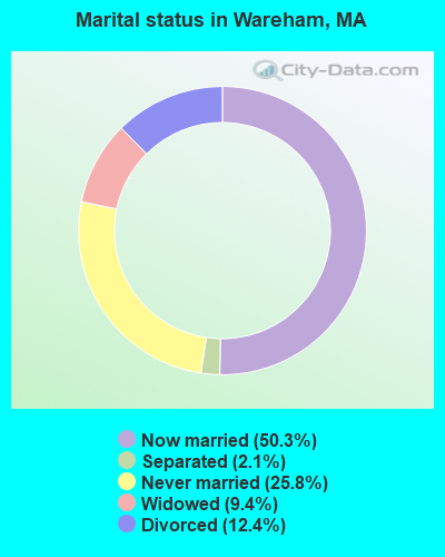
- Never married: 25.8%
- Now married: 50.3%
- Separated: 2.1%
- Widowed: 9.4%
- Divorced: 12.4%
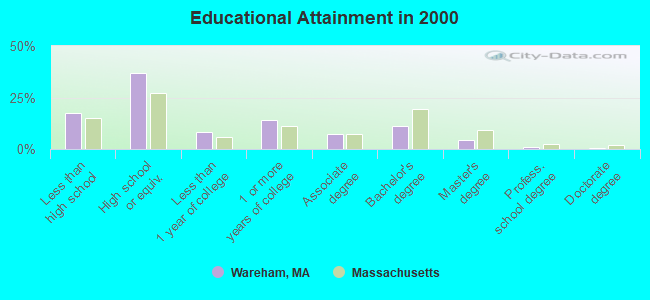
For population 25 years and over in Wareham:
- High school or higher: 82.5%
- Bachelor's degree or higher: 16.3%
- Graduate or professional degree: 5.4%
- Unemployed: 5.4%
- Mean travel time to work (commute): 30.5 minutes
| Here: | 10.3 |
| Massachusetts average: | 13.1 |


Graphs represent county-level data. Detailed 2008 Election Results
Religion statistics for Wareham, MA (based on Plymouth County data)


| Religion | Adherents | Congregations |
|---|---|---|
| Catholic | 165,985 | 35 |
| Mainline Protestant | 23,724 | 91 |
| Evangelical Protestant | 13,159 | 96 |
| Other | 6,129 | 43 |
| Orthodox | 1,140 | 3 |
| Black Protestant | 611 | 5 |
| None | 284,171 | - |
Food Environment Statistics:
| Plymouth County: | 1.74 / 10,000 pop. |
| Massachusetts: | 1.98 / 10,000 pop. |
| This county: | 0.04 / 10,000 pop. |
| Massachusetts: | 0.05 / 10,000 pop. |
| This county: | 2.84 / 10,000 pop. |
| State: | 2.22 / 10,000 pop. |
| This county: | 2.20 / 10,000 pop. |
| Massachusetts: | 1.77 / 10,000 pop. |
| Plymouth County: | 7.37 / 10,000 pop. |
| Massachusetts: | 8.76 / 10,000 pop. |
| This county: | 7.9% |
| State: | 8.1% |
| Plymouth County: | 21.7% |
| State: | 22.5% |
| Here: | 16.3% |
| State: | 16.5% |
5.54% of this county's 2020 resident taxpayers moved to other counties in 2021 ($85,482 average adjusted gross income)
| Here: | 5.54% |
| Massachusetts average: | 7.18% |
0.01% of residents moved to foreign countries ($80 average AGI)
Plymouth County: 0.01% Massachusetts average: 0.02%
Top counties to which taxpayers relocated from this county between 2020 and 2021:
| to Bristol County, MA | |
| to Norfolk County, MA | |
| to Suffolk County, MA |
| Businesses in Wareham, MA | ||||
| Name | Count | Name | Count | |
|---|---|---|---|---|
| AT&T | 1 | Old Navy | 1 | |
| Ann Taylor | 1 | Payless | 1 | |
| Bath & Body Works | 1 | Penske | 1 | |
| CVS | 2 | Qdoba Mexican Grill | 1 | |
| Curves | 1 | Red Robin | 1 | |
| Decora Cabinetry | 2 | Rite Aid | 1 | |
| DressBarn | 1 | Rue21 | 1 | |
| Dressbarn | 1 | Shaw's | 1 | |
| Dunkin Donuts | 4 | Sprint Nextel | 1 | |
| Famous Footwear | 1 | Staples | 1 | |
| FedEx | 2 | Starbucks | 1 | |
| Ford | 1 | T-Mobile | 1 | |
| GNC | 1 | T.J.Maxx | 1 | |
| GameStop | 1 | Target | 1 | |
| H&R Block | 1 | U-Haul | 1 | |
| JCPenney | 1 | UPS | 3 | |
| Justice | 1 | Vans | 1 | |
| Lowe's | 1 | Verizon Wireless | 2 | |
| MasterBrand Cabinets | 2 | YMCA | 1 | |
| Nike | 3 | |||
Strongest AM radio stations in Wareham:
- WBZ (1030 AM; 50 kW; BOSTON, MA; Owner: INFINITY BROADCASTING OPERATIONS, INC.)
- WEEI (850 AM; 50 kW; BOSTON, MA; Owner: ENTERCOM BOSTON LICENSE, LLC)
- WRKO (680 AM; 50 kW; BOSTON, MA; Owner: ENTERCOM BOSTON LICENSE, LLC)
- WALE (990 AM; 50 kW; GREENVILLE, RI; Owner: NORTH AMERICAN BROADCASTING CO., INC.)
- WBSM (1420 AM; 5 kW; NEW BEDFORD, MA; Owner: CITADEL BROADCASTING COMPANY)
- WPLM (1390 AM; 5 kW; PLYMOUTH, MA; Owner: PLYMOUTH ROCK BROADCASTING CO., INC.)
- WKOX (1200 AM; 50 kW; FRAMINGHAM, MA; Owner: CAPSTAR TX LIMITED PARTNERSHIP)
- WBIX (1060 AM; 40 kW; NATICK, MA; Owner: LANGER BROADCASTING CORPORATION)
- WWZN (1510 AM; 50 kW; BOSTON, MA; Owner: ROSE CITY RADIO CORPORATION)
- WCRN (830 AM; 50 kW; WORCESTER, MA; Owner: CARTER BROADCASTING CORPORATION)
- WAMG (890 AM; 25 kW; DEDHAM, MA; Owner: MEGA COMMUNICATIONS OF DEDHAM LICENSEE, LLC)
- WRCA (1330 AM; 25 kW; WALTHAM, MA; Owner: WRCA LICENSE, LLC)
- WPRO (630 AM; 5 kW; PROVIDENCE, RI; Owner: CITADEL BROADCASTING COMPANY)
Strongest FM radio stations in Wareham:
- WJFD-FM (97.3 FM; NEW BEDFORD, MA; Owner: EDMUND DINIS, TRUSTEE)
- WCTK (98.1 FM; NEW BEDFORD, MA; Owner: HALL COMMUNICATIONS, INC.)
- WCIB (101.9 FM; FALMOUTH, MA; Owner: QANTUM OF CAPE COD LICENSE COMPANY, LLC)
- WPLM-FM (99.1 FM; PLYMOUTH, MA; Owner: PLYMOUTH ROCK BROADCASTING CO., INC.)
- WTWV (101.1 FM; MASHPEE, MA; Owner: BOCH BROADCASTING, L.P.)
- WFHN (107.1 FM; FAIRHAVEN, MA; Owner: CITADEL BROADCASTING COMPANY)
- WFPB-FM (91.9 FM; FALMOUTH, MA; Owner: UNIVERSITY OF MASSACHUSETTS)
- WPXC (102.9 FM; HYANNIS, MA; Owner: QANTUM OF CAPE COD LICENSE COMPANY, LLC)
- WWBB (101.5 FM; PROVIDENCE, RI; Owner: CLEAR CHANNEL BROADCASTING LICENSES, INC.)
- WQRC (99.9 FM; BARNSTABLE, MA; Owner: SANDAB COMMUNICATION LTD. PNR/SHP II)
- WXKS-FM (107.9 FM; MEDFORD, MA; Owner: AMFM RADIO LICENSES, L.L.C.)
- WMJX (106.7 FM; BOSTON, MA; Owner: GREATER BOSTON RADIO, INC.)
- WBMX (98.5 FM; BOSTON, MA; Owner: INFINITY RADIO OPERATIONS INC.)
- WBOS (92.9 FM; BROOKLINE, MA; Owner: GREATER BOSTON RADIO, INC.)
- WJMN (94.5 FM; BOSTON, MA; Owner: AMFM RADIO LICENSES, L.L.C.)
- WCRB (102.5 FM; WALTHAM, MA; Owner: CHARLES RIVER BROADCASTING WCRB LICE)
- WTKK (96.9 FM; BOSTON, MA; Owner: GREATER BOSTON RADIO, INC.)
- WROR-FM (105.7 FM; FRAMINGHAM, MA; Owner: GREATER BOSTON RADIO, INC.)
- WATD-FM (95.9 FM; MARSHFIELD, MA; Owner: MARSHFIELD BROADCASTING CO., INC.)
- WSNE-FM (93.3 FM; TAUNTON, MA; Owner: CAPSTAR TX LIMITED PARTNERSHIP)
TV broadcast stations around Wareham:
- WLWC (Channel 28; NEW BEDFORD, MA; Owner: C-28 FCC LICENSEE SUBSIDIARY, LLC)
- WWDP (Channel 46; NORWELL, MA; Owner: NORWELL TELEVISION, LLC)
- WLNE-TV (Channel 6; NEW BEDFORD, MA; Owner: FREEDOM BROADCASTING OF SOUTHERN NEW ENGLAND, INC.)
- WCVB-TV (Channel 5; BOSTON, MA; Owner: WCVB HEARST-ARGYLE TV, INC.)
- WGBH-TV (Channel 2; BOSTON, MA; Owner: WGBH EDUCATIONAL FOUNDATION)
- WPRI-TV (Channel 12; PROVIDENCE, RI; Owner: TVL BROADCASTING OF RHODE ISLAND, LLC)
- WNAC-TV (Channel 64; PROVIDENCE, RI; Owner: WNAC, LLC)
- WDPX (Channel 58; VINEYARD HAVEN, MA; Owner: PAXSON BOSTON-68 LICENSE, INC.)
- WJAR (Channel 10; PROVIDENCE, RI; Owner: OUTLET BROADCASTING, INC.)
- WMFP (Channel 62; LAWRENCE, MA; Owner: WSAH LICENSE, INC.)
- WSBK-TV (Channel 38; BOSTON, MA; Owner: VIACOM INC.)
- WLVI-TV (Channel 56; CAMBRIDGE, MA; Owner: WLVI, INC.)
- WSBE-TV (Channel 36; PROVIDENCE, RI; Owner: RHODE ISLAND PUBLIC TELECOM. AUTHORITY)
- WBZ-TV (Channel 4; BOSTON, MA; Owner: VIACOM INC.)
- WGBX-TV (Channel 44; BOSTON, MA; Owner: WGBH EDUCATIONAL FOUNDATION)
- WFXT (Channel 25; BOSTON, MA; Owner: FOX TELEVISION STATIONS INC.)
- WMPX-LP (Channel 67; DENNIS, MA; Owner: PAXSON BOSTON-68 LICENSE, INC.)
- National Bridge Inventory (NBI) Statistics
- 54Number of bridges
- 469ft / 143mTotal length
- $101,452,000Total costs
- 858,575Total average daily traffic
- 27,612Total average daily truck traffic
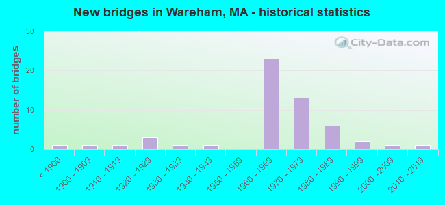
- New bridges - historical statistics
- 1Before 1900
- 11900-1909
- 11910-1919
- 31920-1929
- 11930-1939
- 11940-1949
- 231960-1969
- 131970-1979
- 61980-1989
- 21990-1999
- 12000-2009
- 12010-2019
FCC Registered Cell Phone Towers:
1 (See the full list of FCC Registered Cell Phone Towers in Wareham)FCC Registered Antenna Towers:
18 (See the full list of FCC Registered Antenna Towers)FCC Registered Private Land Mobile Towers:
3 (See the full list of FCC Registered Private Land Mobile Towers in Wareham, MA)FCC Registered Broadcast Land Mobile Towers:
17 (See the full list of FCC Registered Broadcast Land Mobile Towers)FCC Registered Microwave Towers:
6 (See the full list of FCC Registered Microwave Towers in this town)FCC Registered Paging Towers:
5 (See the full list of FCC Registered Paging Towers)FCC Registered Maritime Coast & Aviation Ground Towers:
2 (See the full list of FCC Registered Maritime Coast & Aviation Ground Towers)FCC Registered Amateur Radio Licenses:
53 (See the full list of FCC Registered Amateur Radio Licenses in Wareham)FAA Registered Aircraft:
3- Aircraft: PIPER PA-28-151 (Category: Land, Seats: 4, Weight: Up to 12,499 Pounds, Speed: 80 mph), Engine: LYCOMING 0-320 SERIES (180 HP) (Reciprocating)
N-Number: 6993J, N6993J, N-6993J, Serial Number: 28-7615423, Year manufactured: 1976, Certificate Issue Date: 03/09/1996
Registrant (Individual): Maureen A Cannon, 215 Charge Pond Rd, Wareham, MA 02571 - Aircraft: SCRIVNER GARY SKY STAR KITFOX IV (Category: Land, Seats: 2, Weight: Up to 12,499 Pounds), Engine: ROTAX 912ULS2 (100 HP) (Reciprocating)
N-Number: 7076N, N7076N, N-7076N, Serial Number: 1770, Year manufactured: 2013, Airworthiness Date: 05/18/2013, Certificate Issue Date: 02/14/2013
Registrant (Individual): Markham R Scott, 16 Indian Neck Rd, Wareham, MA 02571 - Aircraft: ROSEN JACK RV9A (Category: Land, Seats: 2, Weight: Up to 12,499 Pounds), Engine: AMA/EXPR UNKNOWN ENG (4 Cycle)
N-Number: 99552, N99552, N-99552, Serial Number: 91471, Year manufactured: 2008, Airworthiness Date: 04/09/2008, Certificate Issue Date: 06/17/2008
Registrant (Individual): Jack Rosen, 2 Irene Ave, Wareham, MA 02571
2002 - 2018 National Fire Incident Reporting System (NFIRS) incidents
- Fire incident types reported to NFIRS in Wareham, MA
- 67841.2%Structure Fires
- 60536.8%Outside Fires
- 28517.3%Mobile Property/Vehicle Fires
- 764.6%Other
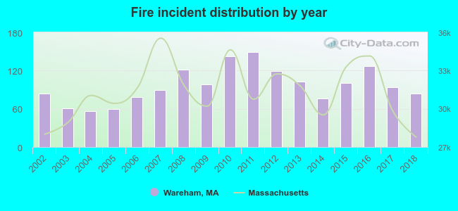 According to the data from the years 2002 - 2018 the average number of fire incidents per year is 97. The highest number of reported fire incidents - 149 took place in 2011, and the least - 56 in 2004. The data has a constant trend.
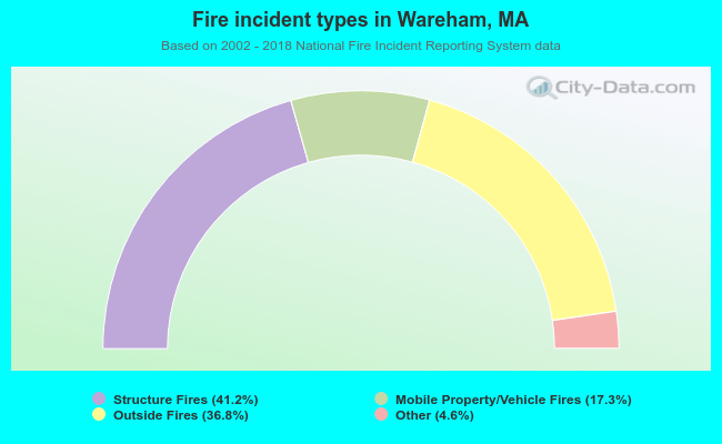 When looking into fire subcategories, the most reports belonged to: Structure Fires (41.2%), and Outside Fires (36.8%).
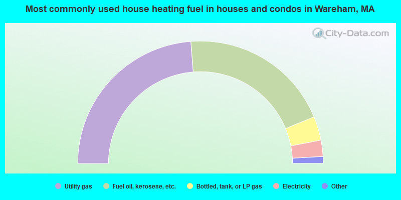
- 47.5%Utility gas
- 40.1%Fuel oil, kerosene, etc.
- 6.3%Bottled, tank, or LP gas
- 4.3%Electricity
- 1.5%Wood
- 0.3%Other fuel
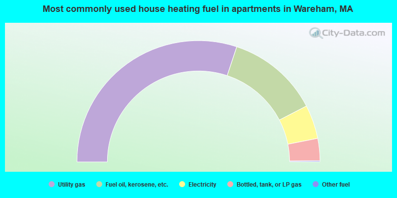
- 60.2%Utility gas
- 24.6%Fuel oil, kerosene, etc.
- 9.0%Electricity
- 5.9%Bottled, tank, or LP gas
- 0.3%Other fuel
Wareham compared to Massachusetts state average:
- Unemployed percentage below state average.
- Black race population percentage below state average.
- Hispanic race population percentage significantly below state average.
- Median age above state average.
- Foreign-born population percentage significantly below state average.
- Renting percentage below state average.
- Length of stay since moving in significantly above state average.
- Number of rooms per house significantly below state average.
- House age significantly below state average.
- Number of college students below state average.
- Percentage of population with a bachelor's degree or higher below state average.
Wareham on our top lists:
- #25 on the list of "Top 101 cities with largest percentage of males in occupations: counselors, social workers, and other community and social service specialists (population 5,000+)"
- #38 on the list of "Top 101 cities with largest percentage of females in occupations: air transportation workers (population 5,000+)"
- #48 on the list of "Top 101 cities with largest percentage of males in occupations: bus drivers (population 5,000+)"
- #60 on the list of "Top 101 cities with largest percentage of males in occupations: cooks and food preparation workers (population 5,000+)"
- #63 on the list of "Top 101 cities with largest percentage of females in industries: printing and related support activities (population 5,000+)"
- #65 on the list of "Top 101 cities with largest percentage of females in occupations: judges, magistrates, and other judicial workers (population 5,000+)"
- #69 on the list of "Top 101 cities with largest percentage of females in occupations: nursing, psychiatric, and home health aides (population 5,000+)"
- #81 on the list of "Top 101 cities with largest percentage of females in industries: petroleum and coal products (population 5,000+)"
- #84 on the list of "Top 101 cities with largest percentage of males in industries: water transportation (population 5,000+)"
- #88 on the list of "Top 101 cities with largest percentage of males in industries: motor vehicle and parts dealers (population 5,000+)"
- #18 on the list of "Top 101 counties with the highest percentage of residents that visited a dentist within the past year"
- #24 on the list of "Top 101 counties with the highest percentage of residents that smoked 100+ cigarettes in their lives"
- #35 on the list of "Top 101 counties with the largest decrease in the number of births per 1000 residents 2000-2006 to 2007-2013 (pop 50,000+)"
- #39 on the list of "Top 101 counties with the lowest percentage of residents that keep firearms around their homes"
- #39 on the list of "Top 101 counties with the lowest number of infant deaths per 1000 residents 2007-2013 (pop. 50,000+)"

|
|
Total of 25 patent applications in 2008-2024.