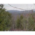
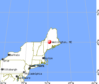
Wellington, Maine
Submit your own pictures of this town and show them to the world
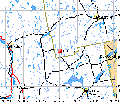
- OSM Map
- General Map
- Google Map
- MSN Map
Population change since 2000: +0.8%
 |
| Males: 130 | |
| Females: 130 |
| Median resident age: | 50.3 years |
| Maine median age: | 43.0 years |
Zip codes: 04942.
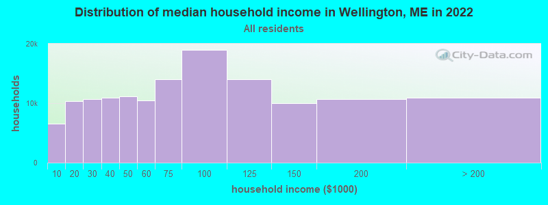
| Wellington: | $31,920 |
| ME: | $69,543 |
Estimated per capita income in 2022: $26,576 (it was $11,216 in 2000)
Wellington town income, earnings, and wages data
Estimated median house or condo value in 2022: $154,479 (it was $59,400 in 2000)
| Wellington: | $154,479 |
| ME: | $290,600 |
Mean prices in 2022: all housing units: $203,844; detached houses: $217,964; townhouses or other attached units: $250,113; in 2-unit structures: $253,343; in 3-to-4-unit structures: $283,591; in 5-or-more-unit structures: $146,783; mobile homes: $82,683
Detailed information about poverty and poor residents in Wellington, ME


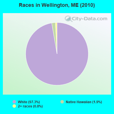
- 25397.3%White alone
- 51.9%Native Hawaiian and Other
Pacific Islander alone - 20.8%Two or more races
Races in Wellington detailed stats: ancestries, foreign born residents, place of birth
 Recent articles from our blog. Our writers, many of them Ph.D. graduates or candidates, create easy-to-read articles on a wide variety of topics.


 | My experience in Maine (99 replies) |
| Wellington, Maine codes & town office (2 replies) |
| still truckin', 60's hippies moving to Maine (93 replies) |
| The Weather..... (505 replies) |
| small town life is what we love. . .please give me some help (41 replies) |
| Deep Thoughts (1103 replies) |
Latest news from Wellington, ME collected exclusively by city-data.com from local newspapers, TV, and radio stations
Ancestries: French (29.1%), Irish (21.3%), English (20.9%), German (9.7%), Polish (5.4%), Lithuanian (4.3%).
Current Local Time: EST time zone
Incorporated on 02/23/1828
Elevation: 571 feet
Land area: 39.9 square miles.
Population density: 6.5 people per square mile (very low).
5 residents are foreign born
| This town: | 1.9% |
| Maine: | 2.9% |
| Wellington town: | 1.0% ($567) |
| Maine: | 1.5% ($1,417) |
Nearest city with pop. 50,000+: Portland, ME  (103.7 miles , pop. 64,249).
Nearest city with pop. 200,000+: Boston, MA (205.3 miles , pop. 589,141).
Nearest city with pop. 1,000,000+: Bronx, NY (364.8 miles , pop. 1,332,650).
Nearest cities:
), ), ), Latitude: 45.08 N, Longitude: 69.57 W
Area code commonly used in this area: 207

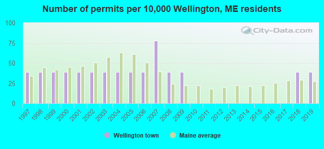
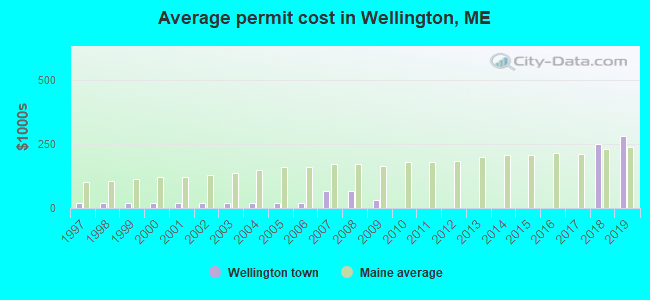
Single-family new house construction building permits:
- 2019: 1 building, cost: $282,200
- 2018: 1 building, cost: $249,800
- 2009: 1 building, cost: $30,000
- 2008: 1 building, cost: $67,500
- 2007: 2 buildings, average cost: $67,500
- 2006: 1 building, cost: $18,000
- 2005: 1 building, cost: $18,000
- 2004: 1 building, cost: $18,000
- 2003: 1 building, cost: $18,000
- 2002: 1 building, cost: $18,000
- 2001: 1 building, cost: $18,000
- 2000: 1 building, cost: $18,000
- 1999: 1 building, cost: $18,000
- 1998: 1 building, cost: $18,000
- 1997: 1 building, cost: $18,000
| Here: | 6.4% |
| Maine: | 3.4% |
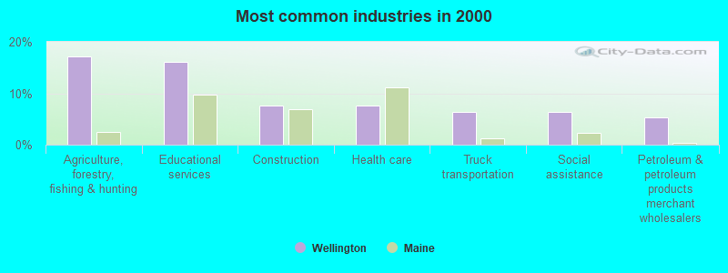
- Agriculture, forestry, fishing & hunting (17.2%)
- Educational services (16.1%)
- Construction (7.5%)
- Health care (7.5%)
- Truck transportation (6.5%)
- Social assistance (6.5%)
- Petroleum & petroleum products merchant wholesalers (5.4%)
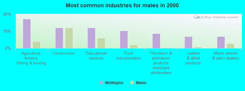
- Agriculture, forestry, fishing & hunting (17.2%)
- Construction (12.1%)
- Educational services (12.1%)
- Truck transportation (10.3%)
- Petroleum & petroleum products merchant wholesalers (8.6%)
- Leather & allied products (6.9%)
- Motor vehicle & parts dealers (6.9%)
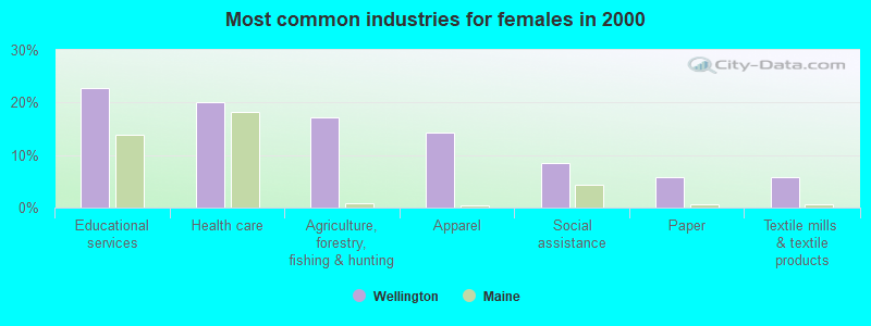
- Educational services (22.9%)
- Health care (20.0%)
- Agriculture, forestry, fishing & hunting (17.1%)
- Apparel (14.3%)
- Social assistance (8.6%)
- Paper (5.7%)
- Textile mills & textile products (5.7%)
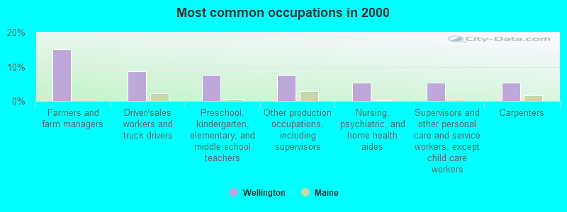
- Farmers and farm managers (15.1%)
- Driver/sales workers and truck drivers (8.6%)
- Preschool, kindergarten, elementary, and middle school teachers (7.5%)
- Other production occupations, including supervisors (7.5%)
- Nursing, psychiatric, and home health aides (5.4%)
- Supervisors and other personal care and service workers, except child care workers (5.4%)
- Carpenters (5.4%)
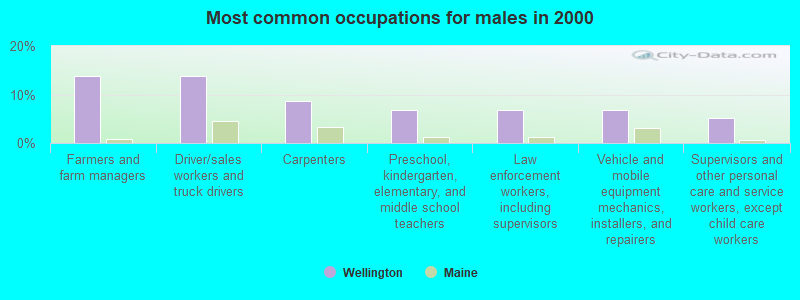
- Farmers and farm managers (13.8%)
- Driver/sales workers and truck drivers (13.8%)
- Carpenters (8.6%)
- Preschool, kindergarten, elementary, and middle school teachers (6.9%)
- Law enforcement workers, including supervisors (6.9%)
- Vehicle and mobile equipment mechanics, installers, and repairers (6.9%)
- Supervisors and other personal care and service workers, except child care workers (5.2%)
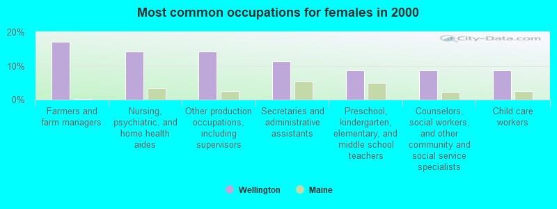
- Farmers and farm managers (17.1%)
- Nursing, psychiatric, and home health aides (14.3%)
- Other production occupations, including supervisors (14.3%)
- Secretaries and administrative assistants (11.4%)
- Preschool, kindergarten, elementary, and middle school teachers (8.6%)
- Counselors, social workers, and other community and social service specialists (8.6%)
- Child care workers (8.6%)
Average climate in Wellington, Maine
Based on data reported by over 4,000 weather stations


Earthquake activity:
Wellington-area historical earthquake activity is significantly above Maine state average. It is 80% smaller than the overall U.S. average.On 4/20/2002 at 10:50:47, a magnitude 5.3 (5.3 ML, Depth: 3.0 mi, Class: Moderate, Intensity: VI - VII) earthquake occurred 206.4 miles away from Wellington center
On 4/20/2002 at 10:50:47, a magnitude 5.2 (5.2 MB, 4.2 MS, 5.2 MW, 5.0 MW) earthquake occurred 207.8 miles away from Wellington center
On 10/16/2012 at 23:12:25, a magnitude 4.7 (4.7 ML, Depth: 10.0 mi, Class: Light, Intensity: IV - V) earthquake occurred 115.7 miles away from Wellington center
On 10/7/1983 at 10:18:46, a magnitude 5.3 (5.1 MB, 5.3 LG, 5.1 ML) earthquake occurred 247.9 miles away from the city center
On 1/19/1982 at 00:14:42, a magnitude 4.7 (4.5 MB, 4.7 MD, 4.5 LG) earthquake occurred 148.4 miles away from Wellington center
On 2/26/1999 at 03:38:43, a magnitude 3.8 (3.8 LG, Depth: 2.0 mi, Class: Light, Intensity: II - III) earthquake occurred 41.5 miles away from the city center
Magnitude types: regional Lg-wave magnitude (LG), body-wave magnitude (MB), duration magnitude (MD), local magnitude (ML), surface-wave magnitude (MS), moment magnitude (MW)
Natural disasters:
The number of natural disasters in Piscataquis County (22) is greater than the US average (15).Major Disasters (Presidential) Declared: 15
Emergencies Declared: 6
Causes of natural disasters: Floods: 13, Storms: 12, Snows: 7, Heavy Rains: 2, Blizzard: 1, Ice Storm: 1, Landslide: 1, Snowfall: 1, Wind: 1, Winter Storm: 1, Other: 2 (Note: some incidents may be assigned to more than one category).
Colleges/universities with over 2000 students nearest to Wellington:
- University of Maine at Farmington (about 41 miles; Farmington, ME; Full-time enrollment: 2,036)
- Husson University (about 42 miles; Bangor, ME; FT enrollment: 2,421)
- University of Maine (about 46 miles; Orono, ME; FT enrollment: 8,931)
- University of Maine at Augusta (about 53 miles; Augusta, ME; FT enrollment: 3,204)
- Saint Joseph's College of Maine (about 98 miles; Standish, ME; FT enrollment: 2,010)
- University of Southern Maine (about 104 miles; Portland, ME; FT enrollment: 6,647)
- Southern Maine Community College (about 105 miles; South Portland, ME; FT enrollment: 4,666)
Points of interest:
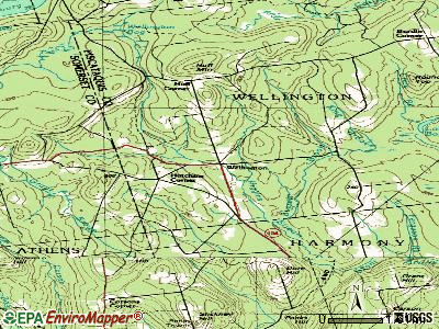
Notable location: Wellington Fire Department (A). Display/hide its location on the map
Cemeteries: Taylor Cemetery (1), Small Philbrick Cemetery (2), Hutchins Corner Cemetery (3), Burdins Cemetery (4). Display/hide their locations on the map
Lakes and swamps: Long Bog (A), Round Bog (B), Ham Bog (C), Woodman Bog (D), Little Woodman Bog (E), Lowell Bog (F), Wellington Bog (G), Whitehouse Bog (H). Display/hide their locations on the map
Streams, rivers, and creeks: King Brook (A), Craig Brook (B), Cook Brook (C), Meadow Brook (D). Display/hide their locations on the map
| This town: | 2.1 people |
| Maine: | 2.3 people |
| This town: | 66.1% |
| Whole state: | 62.9% |
| This town: | 6.5% |
| Whole state: | 9.4% |
No gay or lesbian households reported
| This town: | 16.9% |
| Whole state: | 10.9% |
| This town: | 5.0% |
| Whole state: | 4.1% |
For population 15 years and over in Wellington:
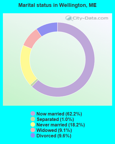
- Never married: 18.2%
- Now married: 62.2%
- Separated: 1.0%
- Widowed: 9.1%
- Divorced: 9.6%
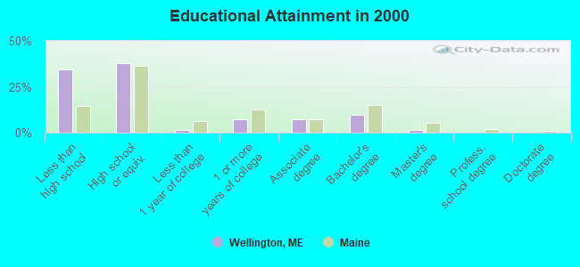
For population 25 years and over in Wellington:
- High school or higher: 65.6%
- Bachelor's degree or higher: 11.1%
- Graduate or professional degree: 1.6%
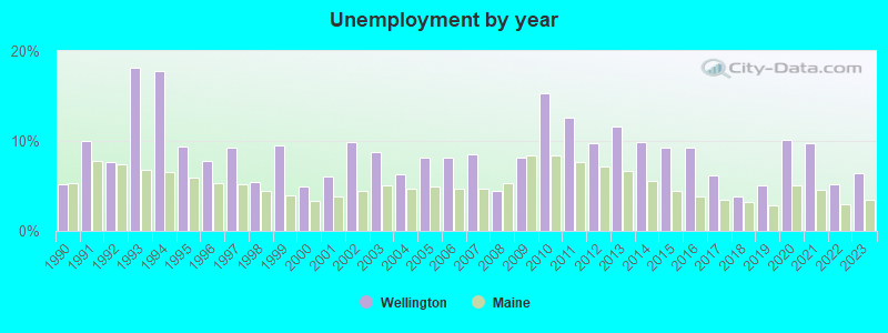
- Unemployed: 5.1%
- Mean travel time to work (commute): 29.3 minutes
| Here: | 12.2 |
| Maine average: | 11.2 |
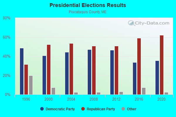
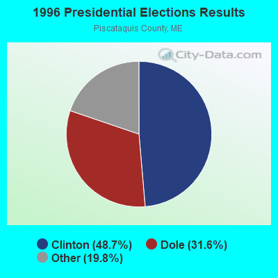
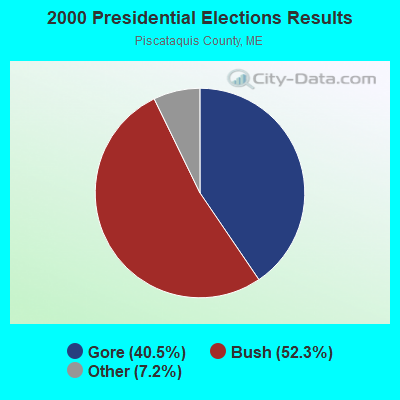
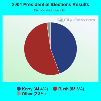
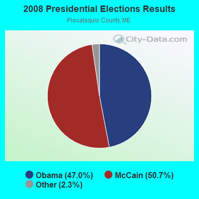
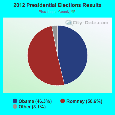
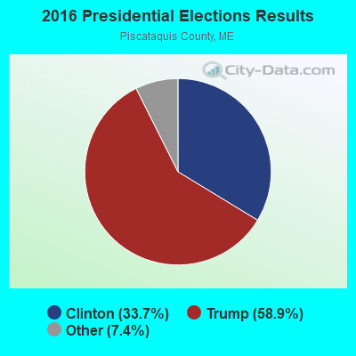
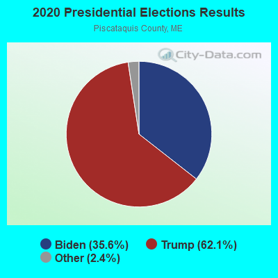
Graphs represent county-level data. Detailed 2008 Election Results
Religion statistics for Wellington, ME (based on Piscataquis County data)
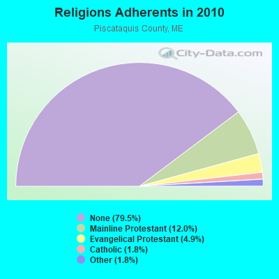
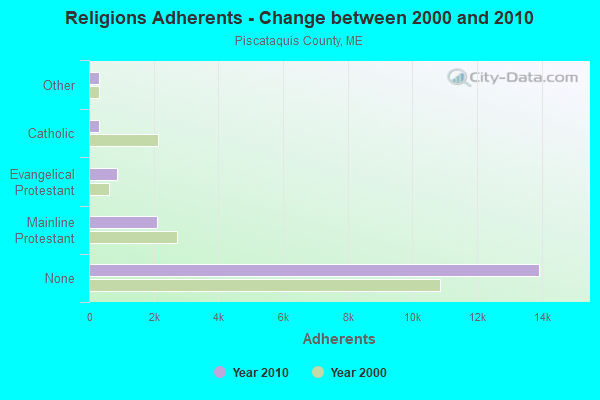
| Religion | Adherents | Congregations |
|---|---|---|
| Mainline Protestant | 2,108 | 13 |
| Evangelical Protestant | 855 | 13 |
| Catholic | 320 | 3 |
| Other | 318 | 5 |
| None | 13,934 | - |
Food Environment Statistics:
| Piscataquis County: | 5.24 / 10,000 pop. |
| Maine: | 2.80 / 10,000 pop. |
| Piscataquis County: | 4.08 / 10,000 pop. |
| Maine: | 2.20 / 10,000 pop. |
| Piscataquis County: | 8.74 / 10,000 pop. |
| Maine: | 5.75 / 10,000 pop. |
| This county: | 10.49 / 10,000 pop. |
| Maine: | 11.02 / 10,000 pop. |
| Piscataquis County: | 8.4% |
| Maine: | 8.2% |
| Here: | 27.5% |
| Maine: | 25.0% |
Strongest AM radio stations in Wellington:
- WSKW (1160 AM; 10 kW; SKOWHEGAN, ME; Owner: MOUNTAIN WIRELESS, INCORPORATED)
- WZON (620 AM; 5 kW; BANGOR, ME; Owner: THE ZONE CORPORATION)
- WTME (780 AM; 10 kW; RUMFORD, ME; Owner: MOUNTAIN VALLEY BROADCASTING, INC.)
- WABI (910 AM; 5 kW; BANGOR, ME; Owner: CLEAR CHANNEL BROADCASTING LICENSES, INC.)
- WRKO (680 AM; 50 kW; BOSTON, MA; Owner: ENTERCOM BOSTON LICENSE, LLC)
- WEEI (850 AM; 50 kW; BOSTON, MA; Owner: ENTERCOM BOSTON LICENSE, LLC)
- WCHP (760 AM; 35 kW; CHAMPLAIN, NY; Owner: CHAMPLAIN RADIO, INC.)
- WBZ (1030 AM; 50 kW; BOSTON, MA; Owner: INFINITY BROADCASTING OPERATIONS, INC.)
- WFAU (1280 AM; 5 kW; GARDINER, ME; Owner: CAPSTAR TX LIMITED PARTNERSHIP)
- WNNZ (640 AM; 50 kW; WESTFIELD, MA; Owner: CLEAR CHANNEL BROADCASTING LICENSES, INC.)
- WCRN (830 AM; 50 kW; WORCESTER, MA; Owner: CARTER BROADCASTING CORPORATION)
- WMTW (870 AM; 10 kW; GORHAM, ME; Owner: RADIO PARTNERS OF MAINE, L.P.)
- WKOX (1200 AM; 50 kW; FRAMINGHAM, MA; Owner: CAPSTAR TX LIMITED PARTNERSHIP)
Strongest FM radio stations in Wellington:
- WQCB (106.5 FM; BREWER, ME; Owner: CUMULUS LICENSING CORP.)
- WTOS-FM (105.1 FM; SKOWHEGAN, ME; Owner: CAPSTAR TX LIMITED PARTNERSHIP)
- WGUY (102.1 FM; DEXTER, ME; Owner: CONCORD MEDIA GROUP, INC.)
- WWBX (97.1 FM; BANGOR, ME; Owner: CLEAR CHANNEL BROADCASTING LICENSES, INC.)
- WHQO (107.9 FM; SKOWHEGAN, ME; Owner: MOUNTAIN WIRELESS, INC.)
- WVOM (103.9 FM; HOWLAND, ME; Owner: CLEAR CHANNEL BROADCASTING LICENSES, INC.)
- WDME-FM (103.1 FM; DOVER-FOXCROFT, ME; Owner: THE ZONE CORPORATION)
- WJCX (99.5 FM; PITTSFIELD, ME; Owner: CSN INTERNATIONAL)
- WCTB (93.5 FM; FAIRFIELD, ME; Owner: MOUNTAIN WIRELESS, INC.)
Wellington fatal accident list:
Jul 23, 1997 06:44 PM, 154, Vehicles: 1, Persons: 2, Pedestrians: 1, Fatalities: 1
Dec 9, 1994 04:45 PM, Huffcorner, Vehicles: 1, Persons: 2, Pedestrians: 1, Fatalities: 1
- National Bridge Inventory (NBI) Statistics
- 3Number of bridges
- 10ft / 3.1mTotal length
- 441Total average daily traffic
- 20Total average daily truck traffic
- 706Total future (year 2036) average daily traffic
FCC Registered Broadcast Land Mobile Towers:
1- WELLINGTON FS, Huff Corner Road (Lat: 45.041167 Lon: -69.591444), Type: Tower, Structure height: 9.1 m, Call Sign: WQMN773,
Assigned Frequencies: 465.200 MHz, Grant Date: 10/06/2020, Expiration Date: 10/06/2030, Certifier: Dave Roberts, Registrant: New Wave Licensing Services Inc., 818 Taneytown Rd, Gettysburg, PA 17325, Phone: (717) 334-0910, Email:
FCC Registered Amateur Radio Licenses:
7- Call Sign: KA1DYN, Licensee ID: L01310818, Grant Date: 01/08/2016, Expiration Date: 03/05/2026, Certifier: Mary E Ward, Registrant: Mary E Ward, 5 Huff Corner Road, Wellington, ME 04942-8709
- Call Sign: N1UVK, Licensee ID: L00996149, Grant Date: 02/10/2015, Expiration Date: 04/14/2025, Certifier: James K Karanis, Registrant: James K Karanis, 10 Reed Road, Wellington, ME 04942
- Call Sign: KB1VAV, Licensee ID: L01607448, Grant Date: 09/28/2020, Expiration Date: 12/10/2030, Certifier: Bryant R Garrett, Registrant: Bryant R Garrett, 27 Zion Rd, Wellington, ME 04942
- Call Sign: KL3UX, Licensee ID: L01842790, Grant Date: 11/16/2023, Expiration Date: 02/13/2034, Certifier: Michael W Briggs, Registrant: Michael W Briggs, 55 Huff Corner Rd, Wellington, ME 04942
- Call Sign: KL3VA, Licensee ID: L01844929, Grant Date: 11/28/2023, Expiration Date: 02/24/2034, Certifier: Angela M Briggs, Registrant: Angela M Briggs, 55 Huff Corner Rd, Wellington, ME 04942
- Call Sign: KC1EZT, Licensee ID: L02000837, Grant Date: 02/08/2016, Expiration Date: 02/08/2026, Certifier: David S Fairbanks, Registrant: David S Fairbanks, 84 Parkman Rd, Wellington, ME 04942
- Call Sign: KC1QNI, Licensee ID: L02531362, Grant Date: 02/28/2022, Expiration Date: 02/28/2032, Certifier: Kevin P Jones, Registrant: Kevin P Jones, 77 Huff Corner Rd, Wellington, ME 04942-8710
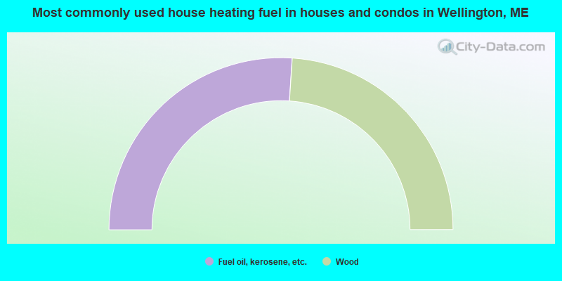
- 52.1%Fuel oil, kerosene, etc.
- 47.9%Wood
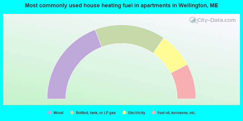
- 38.5%Wood
- 30.8%Bottled, tank, or LP gas
- 15.4%Electricity
- 15.4%Fuel oil, kerosene, etc.
Wellington compared to Maine state average:
- Median household income below state average.
- Median house value below state average.
- Unemployed percentage below state average.
- Black race population percentage significantly below state average.
- Hispanic race population percentage significantly below state average.
- Median age above state average.
- Foreign-born population percentage below state average.
- Renting percentage significantly below state average.
- Length of stay since moving in significantly above state average.
- Number of rooms per house significantly below state average.
- House age significantly below state average.
- Percentage of population with a bachelor's degree or higher significantly below state average.