


About the Garmin nüLink!™ 1695

Imagine you're traveling in an unfamiliar area and you suddenly remember you need to fill a prescription. With most portable navigators, you'd have to wade through several menu screens to locate a pharmacy. Garmin's nüLink! 1695 portable navigator offers local real-time search results that help you find what you're looking for — just type "pharmacy" into the search field and it'll show you results for your location. The nüLink! 1695 also offers built-in Bluetooth® connectivity, a big 5" screen, and Garmin's trademark user-friendly guidance.
Get more with Garmin nüLink! Services
With your 1-year free trial subscription to nüLink! Services (a $60 value), you can access Google™ Local Search results for just about any type of destination in your area, from gas stations and hospitals to tobacco shops, vegan coffeehouses, party supply stores, and other off-the-beaten-path locations. You'll get instant results for your search, whether it's for "the best barbecue in Memphis" or "veterinary clinic." Once you've found a spot, just hit "Go" and you'll be routed there straightaway. nüLink! Services are available in most areas of the U.S. and Puerto Rico, including parts of Alaska and Hawaii.
Real-time traffic updates
The nüLink! Services give you real-time traffic updates on congestion along your route. You can also see area fuel prices, weather reports, movie and local events listings, or even check flight times at the nearby airport. With premium content available for an additional cost, you can add advanced weather reports (including radar and severe alerts) and safety camera warnings. You can send a location from your office computer, smartphone, or other Internet-enabled device to the nüLink! 1695 for further reference once you hit the road.
Intelligent guidance
Garmin's myTrends™ feature works with your favorite destinations to predict when you'll arrive at a location without having to enter a route. Over time, the nüLink! 1695 learns your driving habits, tracking when you'll be heading to the office, the softball field, or another preferred spot. The trafficTrends™ feature monitors traffic flow along your most-traveled paths; it'll pick a better route and predict your arrival time based on the time and day of the week.
Garmin's route planning capabilities let you save 10 routes, specify via points, and preview simulated turns onscreen. The navigator also sorts multiple stopping points in the same trip so you take the most efficient route when you're running errands. It can also display posted speed limits along highways and interstates.
Ideal for any kind of trip
You'll have access to detailed maps of Canada, Puerto Rico, and the entire U.S. on the 5" touchscreen, with text-to-speech voice prompts that announce actual street names leading the way. Lane guidance puts you in the right spot for upcoming turns, and you'll find photo-realistic views of many complicated intersections for added reliability. Garmin's ecoRoute™ feature saves you gas and money by calculating the most fuel-efficient route.
Extras for the road
Bluetooth connectivity allows you to make and receive hands-free calls with your compatible phone. The navigator also includes a built-in digital picture viewer that lets you enjoy all the photos on your personal microSD™ memory cards. You can also purchase SD cards from Garmin with travel guides and coupons to aid you on your journeys.
Product highlights:
- portable GPS navigator
- suction-cup windshield mount
- JPEG picture viewer
- car power adapter and built-in rechargeable battery with 3 hours of life
Navigation features:
- 5" (480 x 272 pixels) display with touchscreen control
- local search powered by Google (unlimited points of interest)
- 6 million points of interest (allows custom points of interest)
- includes nüLink! receiver with free 1-year subscription to nüLink! Services included (additional subscription required after trial period)
- preloaded with maps for Canada, Puerto Rico, and the entire United States
- voice prompts announce road names over the built-in speaker
- lane guidance with junction view
- myTrends and trafficTrends automatically predict arrival times depending on time and day of week
- ecoRoute calculates a more fuel-efficient route
- built-in travel kit including world clock, currency and measurement converters, calculator, and more
- security feature allows you to disable most functions with a user-entered password
- multi-destination routing: route optimization
- transport modes: auto, pedestrian
Expandability:
- microSD card slot
Other features and specs:
- Bluetooth technology: conduct hands-free calls with your compatible cell phone
- dimensions: 5-9/16"W x 3-1/2"H x 13/16"D
- weight: 8.2 oz.
- warranty: 1 year
- MFR # 010-00912-00
What's in the box:
Garmin nüLink! 1695 owner's manual
- Portable GPS navigation receiver
- Suction-cup mounting bracket
- Mounting cradle
- Cigarette lighter adapter with attached 68" cable
- 19.5" USB cable (has Type A USB connector on one end and a Mini-B USB Ver.2.0 connector on the other end)
- Quick Start manual (English)
- Quick Start Manual (Spanish)
- Important Safety and Product Information
- Accessory Guide
- Free dash disk offer
Customer reviews for Garmin nüLink!™ 1695
Loading...
Loading reviews...
Average review:
4.0 out of 5 starsThanks for submitting your review
Customer photos


This review was collected as part of a promotion
Pros:
Cons:

More details on the Garmin nüLink!™ 1695

Features & specs
| Features | ||
|---|---|---|
| Maps | Updates optional | |
| Map Coverage | USA (50), CA, PR, MX | |
| Points of Interest | 6,000,000 | |
| Multiple Destination Routing | Yes | |
| Screen Size | 5" | |
| Bluetooth Capable | Phone | |
| Text To Speech | Yes | |
| Voice Control | No | |
| Traffic Information | nüLink (NAVTEQ) | |
| Dynamic Content Services | Garmin nüLink | |
| Removable Memory Type | microSD card | |
| Battery Life | 3 Hours | |
| Warranty | ||
| Parts Warranty | 1 Year | |
| Labor Warranty | 1 Year | |
Product Research
Navigation Features
Traffic Information
Picture Viewer
Built-in Bluetooth
Mounting Options
Power Requirements
Computer Requirements
Navigation Features
GPS Receiver: The Garmin nüLink 1695 is equipped with a high-sensitivity WAAS-enabled GPS receiver with HotFix which enables faster GPS performance. It must acquire a GPS (Global Positioning System) satellite signal in order to navigate. If you are indoors, near tall buildings or trees, or in a parking garage, the nüLink 1695 cannot acquire satellites. Go outside to an area free from tall obstructions to use the nüLink 1695.
Built-in GPS Antenna: The unit has a built-in antenna in its top panel. In order to obtain an optimal signal, the unit must have a clear, unobstructed view of the sky. It the unit is mounted in a vehicle with a coated windshield or an in-screen heating system, there may be difficulty in obtaining a good signal.
Pre-loaded NAVTEQ Maps: The Garmin nüLink 1695 comes pre-programmed with NAVTEQ's City Navigator North America NT 2011 maps. Detailed road maps of the entire United States, Canada, Puerto Rico, the U.S. Virgin Islands and Mexico are included. Over 500,000 additional miles of road coverage and nearly 6,000,000 Points of Interest (POIs) such as hotels, restaurants, gas stations, attractions, and ATMs are included to help you find the destination you desire.
Note: You can purchase additional MapSource map data from Garmin and load the maps to the nüLink 1695's internal memory or inserted microSD card (via USB connection).
nuMaps Updates: If you register the nüLink 1695 online within 60 days of acquiring satellites and driving with the unit, you may be eligible for a free map update, if available. Additional maps can be purchased for the Garmin nüLink device at any time.
Note: For a one-time payment (150NULIFE, sold separately), you can receive up to four map update each year for the life of the unit.
Touchscreen Display: The unit features a bright, 5.0" (diagonal) WQVGA color TFT LCD with touchscreen controls. The display has a resolution of 480 x 272 pixels, with an aspect ratio of 16:9 and 64,000 colors. The screen has a manual brightness adjustment. You can select one of three color modes for the display screen:
- Daytime: Has a lighter, brighter background.
- Nighttime: Has a black background, easier to see at night.
- Auto: Display automatically switches between daytime and nighttime at sunrise and sunset.
Note: The screen will automatically shut off if the device in inactive for the selected length of time.
Information Pages: The information provided by the nüLink 1695 is found on various display screens called pages. The pages give you the following information:
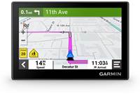
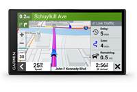
- Map:
- Indicates real-time moving map illustrating your current position and intended route
- Shows map scale and geographic details such as lakes, rivers, highways and towns
- Allows you to zoom, pan, and point using the touch screen controls
- When you are following a route, your arrival time is displayed in the lower left corner, your current speed is shown in the lower right corner. The posted speed limit for most major roads is displayed near the lower right corner as well.
- When you are simply driving while viewing the Map page (not following a route), your speed is shown in the lower right corner (along with the road's speed limit), the direction you are driving is shown in the lower left corner
- Trip Information:
- Shows current compass heading while moving
- Indicates current speed, maximum speed, arrival time, distance and time to next turn
- Calculates driving time, stopped time and total time
- Displays overall distance traveled (odometer) and distance to your final destination
- Current Route:
- Displays a list of turn-by-turn instructions for your entire route as well as arrival information
- Shows direction of each turn and distance
- Next Turn:
- Shows the next turn on the map and the distance and time left before you reach the turn
Navigation Map: The Garmin nüLink 1695 displays a real-time moving map illustrating your current position and intended route. It will show map scale and geographic details such as lakes, rivers, highways and towns. Your route is marked with a magenta line. A checkered flag marks your destination. As you travel the nüLink 1695 guides to your destination with arrows on the map and directions at the top of the screen. During your calculated route, your arrival time is displayed in the lower left corner, your current speed is shown in the lower right corner. The posted speed limit for most major roads is displayed near the lower right corner as well. The unit allows you to zoom, pan, and point using the touchscreen during navigation. You can select one of three map orientation displays:
- 2D Track Up: Two-dimensional map that constantly displays the route from bottom to top of the screen.
- 2D North Up: Two-dimensional map that constantly displays North at the top of the screen.
- 3D Track Up: Three-dimensional map that constantly displays the route from bottom to top of the screen.
Text-to-Speech Audible Directions: In addition to the visual map, you get voice-prompted, turn-by-turn directions that speak street names to your destination; allowing you to keep your eyes more comfortably on the road. The nüLink 1695 offers male and female voices of various languages. You can also download custom voices from the "Garmin Garage" website.
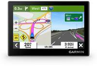
Lane Assist with Junction View: Lane assist with junction view guides you to the correct lane for an approaching turn or exit, making unfamiliar intersections and exits easy to navigate. It realistically displays road signs and junctions on your route along with arrows that indicate the proper lane for navigation. As you navigate your route, the unit will provide detailed diagrams of the proper lane to travel when maneuvering a complex interchange. The Junction View page will display what the actual approaching junction looks like, and arrows indicating the lane in which you should be driving.
Where Am I?: The "Where Am I?" feature gives you instant access to important information in case of an emergency. When you select "Where Am I?" from the menu, you get the coordinates (including elevation) of your current position, plus the nearest address and intersections. There are also buttons to help you locate the nearest hospitals, police stations, gas stations, and roadside assistance. You can also save the location for future reference.
Where To?: During navigation, you can search for places by pressing "Menu", then "Where To?" You can select an Address, Go Home, Points of Interest (6,000,000), Recently Found (up to 50), Favorites (up to 1,000), Parking (saves last parking spot), Extras (custom POIs), Intersections, Cities, Browse Map, and Coordinates (latitude/longitude). You can also access Spell Name for direct entry of your new destination, or browse the map. You can search for locations near your present location (default), or select a different city, your current route, or your destination.
| Destination Search | Description |
|---|---|
| Browse Map | Search for a destination by scrolling the map display |
| Go Home | Store and easily recall your home address |
| Address | Enter a specific address; state, city, street number, street |
| Cities | Search For a city (central location) |
| Intersections | Search for the intersection of two roads |
| POIs | Search for points of interest (POIs) by name or category; search near your current location, in a specific city, along your current route, or near your destination |
| Parking | Find parking-lots and parking garages near you; the device also saves your parking spot when your remove the device from the mount so you can find your vehicle easier when you return |
| Trip Planner | You can use Trip Planner to create and save a trip with multiple destinations |
| Favorites | Store up to 1,000 of your favorite locations |
| Recently Found | Stores the last 50 places found |
| Coordinates | Enter geographic coordinates (latitude & longitude) |
| Extras | Add extra information via a microSD card; custom points of interest, Garmin Travel Guide, Safety Camera information, TourGuide, Language Guide, and SaversGuide available on Garmin's website |
Keyboard Options: The nüLink 1695 gives you two options for keyboard layouts. When you are entering an address or other data, you can choose between a standard QWERTY keyboard layout or an ABCDE alphabetical layout.
Transportation Modes: The Garmin nüLink 1695 offers several transportation modes for navigation methods. It can be used in any of two transportation modes: automotive and pedestrian. Routing is calculated differently based on your mode.
Vehicle Icons: The default on-screen icon representing your vehicle is a blue sports car. In the menu, you can select a blue 4WD pickup truck, a blue compact car, a blue 3D arrow, a pair of boots, a large bird, or a rolling beach ball. You can also download other vehicle icons from the "Garmin Garage" website.
Route Preferences: When calculating a route, you can select the following preferences: faster time, shorter distance, less fuel, Off road, or Prompted. The Prompted mode calculates the Faster Time, Shorter Distance, and Less Fuel routes and allows you to view them all on the map prior to selecting the route.
Avoidances: You can program the unit to avoid certain things that may be undesirable on your route. Examples of things that can be avoided include U-Turns, Highways, Toll Roads, Carpool Lanes, Unpaved Roads, and Ferries.
Waypoints: You can manually mark and name any map position as a waypoint for later recall. Up to 1000 waypoints can be saved into memory.
Custom Routes: The nüLink 1695 allows you to create custom routes for errands, deliveries, or sales calls, and automatically sort the destinations in the most efficient order. You can save up to 100 routes, specify via points, and preview simulated turns on the unit's display. In addition, a trip log provides an electronic breadcrumb trail of up to 10,000 points, so you can see where you've traveled on the map.
Custom Points of Interest: The nüLink 1695 will accept custom points of interest (POI) databases, available from various companies on the Internet. Some custom POI databases contain alert information for points such as safety cameras and school zones, and the unit can notify you as you approach one of these points. To download custom POIs, you will need the Garmin POI Loader software, available on Garmin's website.
ecoRoute: The ecoRoute feature calculates your vehicle's fuel economy, carbon footprint, and the fuel price of navigating to a destination. It also offers tools for improving fuel efficiency. Through ecoRoute's Fuel report and Mileage Report, you can track fuel usage and gas mileage during each trip. There is also a driving challenge to help you maximize your fuel economy by scoring your driving habits.
Auto Reroute: If you deviate from the original route, the nüLink 1695 recalculates the route and provides new directions.
Detour: If a road ahead is closed or congested with traffic, you can take a detour using the nüLink 1695. The nüLink 1695 attempts to find an alternate route that avoids the current road or the next road on your turn list, and then returns to your original route. If the route you are currently navigating is the only reasonable option, the nüLink 1695 might not calculate a detour.
Indoor Use: When indoors, you can activate the built-in simulator and practice using the unit. This turns off the GPS receiver so it's not searching for satellites.
Trip Planner: You can use the Trip Planner to create and save a trip with multiple destinations. The Trip Planner allows you to set a departure time and trip duration.
Tools: The nüLink 1695 offers several tools you can use as you travel:
- World Clock: The world clock allows you to display the current time for four locations throughout the world. You can also display a map of the world showing which portions are in daylight and which are in darkness.
- Currency Converter: This feature allows you to update the currency rates manually so you are always using the most current information.
- Unit Converter: You can convert area, distance, speed, temperature, volume, and weight.
- Calculator: The calculator allows you to perform simple arithmetic.
Security Settings: The Garmin nüLink 1695 offers two security settings.
- Garmin Lock: This anti-theft feature disables the unit from performing any functions until you type in a specific 4-digit PIN or take the unit to a predetermined location.
- Safe Mode: With the Safe Mode turned on, functions that require significant operator attention are disabled so they don't become a distraction while riding.
Traffic Information
Garmin nüLink! Services: You can get accurate real-time information about the area you're traveling in delivered directly to your nüLink 1695 via a built-in wireless module. For a limited time, the nüLink 1695 comes with a 1-year trial subscription. Garmin nüLink! Services include the following applications:
- Google Local Search: Access up-to-date information for the local area using the power of Internet-enabled local search and navigate directly from the search results.
- Gas Prices: Garmin nüLink! services show you where you can find the best prices for any grade of fuel in your area.
- Weather: Tap the weather icon and receive current and 5-day forecasts for major cities around the world.
- Local Events: Find out what's going on in town by searching for concerts, theater performances, sports, and art, and navigate to the venue.
- Flight Status: Get quick access to flight departure/arrival times and gate information from airports around the world with the closest major airports displayed first.
- White Pages: Find addresses by name or phone number using the White Pages application. After the address is found, you can immediately navigate to the location.
- Real-time Traffic: You can receive current traffic data for your route so your nüLink 1695 can automatically optimize a route for the shortest time.
- Ciao!: Keep up with what your friends are doing. Ciao! integrates multiple third-party location-centric social network applications, such as GyPSii, with more networks to be added in the future.
- Movie Times: Use Garmin nüLink! services to find an area movie theater, along with titles and showtimes.
- Send to GPS: Build a list of destinations online and send them wirelessly to your nüLink 1695.
- Money Converter: Convert up-to-date currency evaluations, plus measurements, distances, speed, and temperatures.
- myGarmin: When updates are available, you'll receive alerts via Garmin nüLink!, so you can download them automatically.
nuRoute Technology: The nüLink 1695 features Garmin's nuRoute Technology with trafficTrends and myTrends.
- trafficTrends: When the trafficTrends features is enabled, the GPS device uses historic traffic information to calculate more-efficient routes. Different routes may be calculated based on traffic trends for the day of the week or based on the time of day. The historic traffic information used by trafficTrend is uploaded to the Garmin nüLink 1695 when you connect the device to your computer and go to the "myGarmin" website.
- myTrends: When you enabled myTrends, estimated travel times and traffic information for your frequent destinations appear in the navigation bar at the op of the map. To activate myTrends information, you must add your frequent destinations to your Favorite. After you have completed routes to your frequent destinations on multiple occasions, myTrends information appears in the navigation bar.
Picture Viewer
microSD Memory Slot: The nüLink 1695 has a microSD memory slot for additional map data from optional microSD memory cards. The unit can also display JPEG photo images from a microSD memory card.
Picture Viewer: The nüLink 1695 can display photo images (JPEG files). The image files must be stored on an optional microSD memory card or transferred to the internal memory.
Photo Navigation: You can navigate to photos that included location information, called geotags. The Panoramio (www.panoramio.com) website provides photographs that include location information called geotags. These photos can be downloaded into the nüLink 1695 or microSD memory card, and the unit can route you to the location.
Built-in Bluetooth
Bluetooth Communication: Many Bluetooth-capable cellular phones are compatible with the nüLink 1695 allowing you to use the GPS device as a hands-free car kit. The nüLink 1695 has both a microphone and speaker, so no additional equipment is necessary to integrate your Bluetooth phone. Available options will vary by phone, however, generally these apply:
- accept or ignore incoming calls on the touch screen
- dial your home number
- enter a number manually
- call a POI (Point Of Interest)
- dial a number in your phone book
- call a recently dialed number
- dial a recent caller
- send or receive text messages
Bluetooth Compatibility: Visit http://my.garmin.com/bluetooth/phones.faces for a complete list of Bluetooth compatible mobile phones.
Mounting Options
Mounting: The unit should be securely installed when used in a vehicle. The unit comes with a mounting bracket that includes a suction cup. The suction cup can be used to mount the unit to the windshield. Once the nüLink 1695 is mounted, it can be adjusted on the ball-and-socket bracket for best visibility. The unit must be installed where it has a relatively unobstructed view of the sky.
Optional Pro.Fit G3 Vehicle Specific Mounts: The Garmin nüLink GPS units are directly compatible with the optional Pro.Fit G3 series of Vehicle Specific Mounts (VSMs). The G3 Series mounts have a ball-and-socket mechanism that perfectly fits the nüLink mounting cradles, giving you a custom mount designed for your vehicle. Please check the Crutchfield vehicle selector to see if a G3 Series VSM is available for your vehicle. If the original or Legend series Pro.Fit VSM is the only available option for your vehicle, the Garmin nüLink adapter (042TT39) can be purchased and attached to the VSM.
Power Requirements
Power Source: The Garmin nüLink 1695 operates on your vehicle's battery using the included 12-volt cigarette lighter power adapter, the built-in Lithium-Ion battery, or household current using an optional AC adapter (sold separately). The integrated Lithium-Ion battery provides up to 3 hours of use after a 4-hour charge.
Note: Stored data, such as waypoints or unit settings, are not lost when the unit is disconnected from a power source.
Battery Charging: The integrated Lithium-Ion battery can be charged using the included 12-volt cigarette lighter power adapter in your vehicle, plugging the supplied USB cable into your computer, or connecting the optional AC power adapter (sold separately).
Sleep Mode: You can use the Sleep Mode to conserve battery power when the device is not in use. Sleep Mode uses very little power, and a battery charge can last for weeks.
Computer Requirements
Internal Memory: The nüLink 1695 comes with an internal memory for storage of supplemental maps and photos. When the unit is connected to your computer, the nüLink 1695 is recognized as a USB Mass Storage device.
Interface Capability: This unit is connected to a PC via the supplied USB cable for software and navigation updates. This interface allows you to download additional map and software information to the unit's flash memory or inserted microSD card.
Note: The unit's USB port is USB 2.0 Full Speed compatible.
Computer Compatibility: The nüLink 1695 is compatible with Windows XP or newer and Mac OS X 10.4 or later.
Note: The nüLink 1695 is not compatible with Windows 95, Windows 98, Windows Me, or Windows NT. It is also not compatible with Mac OS 10.3 and earlier. This is a common limitation of most USB mass storage devices.
Loading...
Loading accessories...
Customer Q&A
Loading...
Loading articles...

Excellent unit, with Local Google search option make this GPS unique. Love it
JuliuszT from Charlotte, NC