

Seattle weather: Rainy, gusty and cloudy on Christmas Day
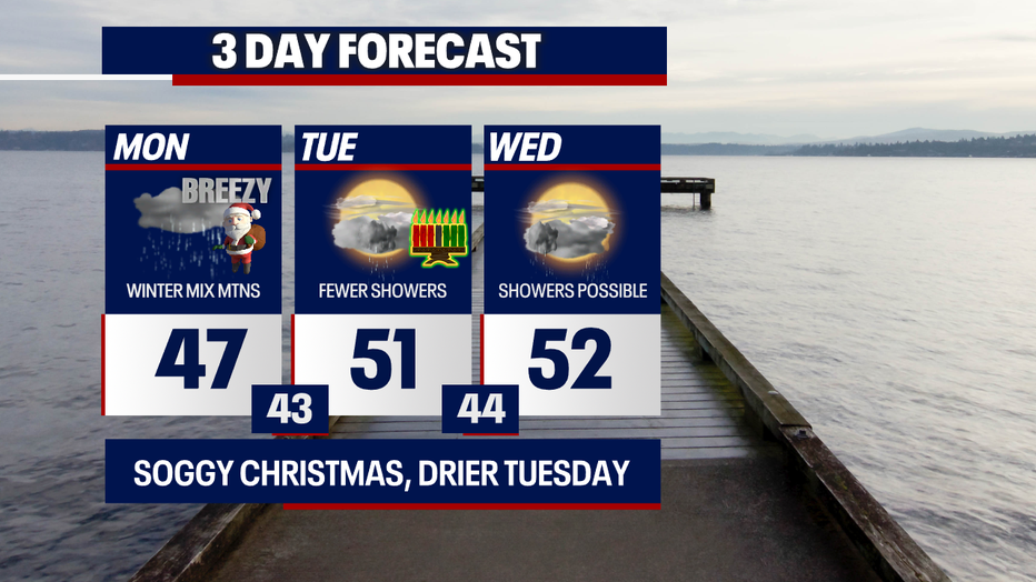
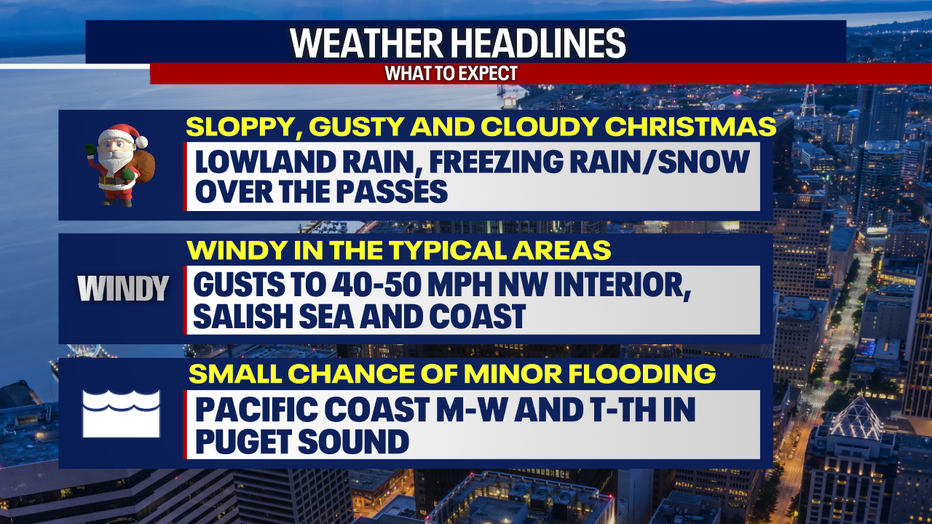
If you love rainy, cloudy weather, you'll thoroughly enjoy our cozy forecast for Christmas. For those hoping for sunnier skies, you'll be treated to blue skies briefly tomorrow :)
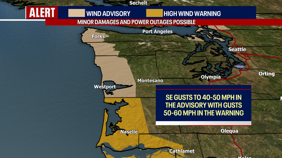
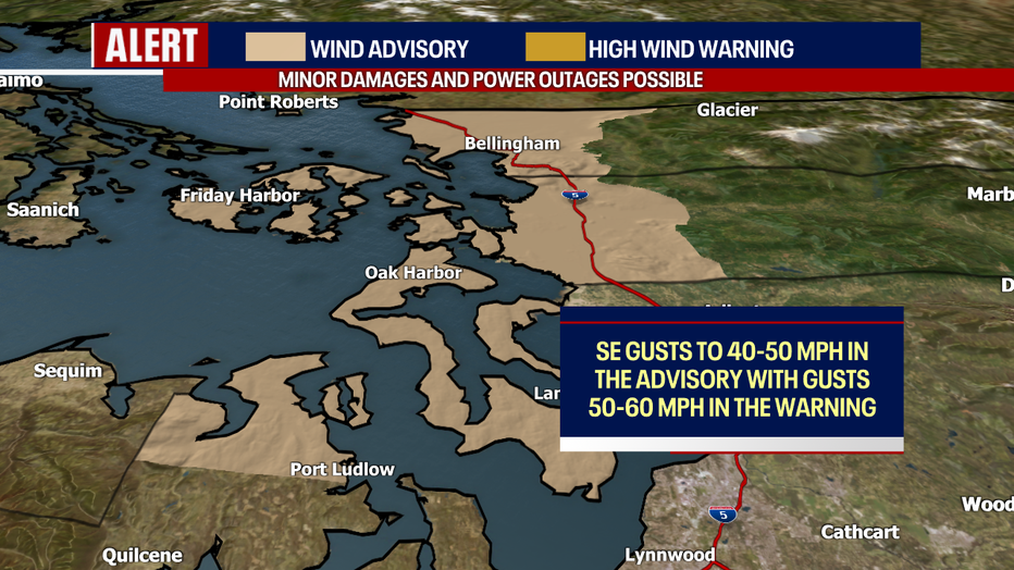
For the highest populated areas in Western Washington (including Snohomish, King and Pierce Counties), today will be remembered as gray, wet and breezy – nothing too out of the ordinary for this time of year. However, for communities in the North Sound, Salish Sea and coast, strong winds are in the forecast. In the areas highlighted in official wind alerts below, there could be minor damages and power outages today.
In the Wind Advisory, gusts to 40-50 mph are possible. For the South Washington Coast, gusts between 50-60 mph could be more impactful. The warning lasts from 6 tonight to 1 a.m. Tuesday. The advisory runs from 10 a.m. today to 4 a.m. Tuesday. Secure any outdoor Christmas decor and charge your phones in case an outage happens (I hope not!).
At times the next few days, it could be gusty for the Cascade "gap" communities (e.g. Monroe, North Bend, Enumclaw and Eatonville). Those towns could experience moderate gusts in the 20-30+ mph range at times today through Wednesday. At the current moment, these winds aren't strong enough to warrant any official wind alerts. We'll let you know if anything changes! The winds won't be constant, but it's worth monitoring. Elsewhere in Puget Sound, gusts could reach 25-30 mph on Christmas.
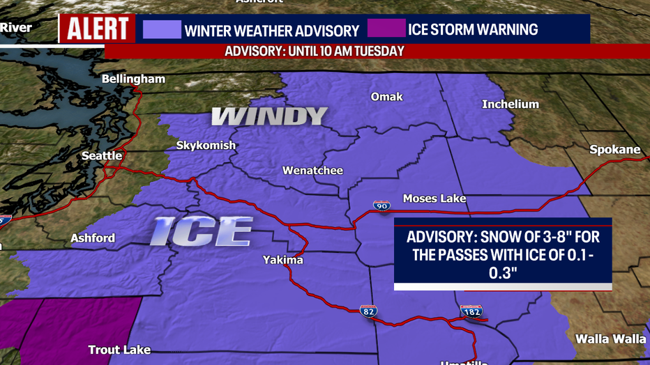
Over the passes today, there might be a dangerous mix of freezing rain and snow. If you're hoping to travel over the passes, make sure your car is completely prepared for winter driving and check WSDOT conditions before heading out on the road. I'd advise you to be ready to adjust your travel plans if conditions are looking too treacherous. There's another chance for light freezing rain Tuesday evening over the passes. Stay tuned for further updates.
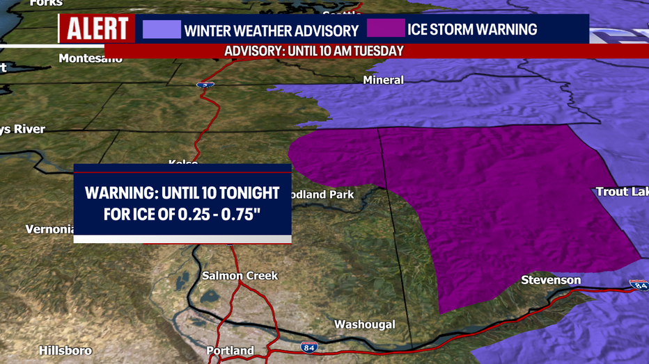
There's a Winter Weather Advisory in effect in the purple on the map below. In the light purple, the advisory for the Cascades is in effect until 10 a.m. Tuesday. Even though freezing rain amounts will be fairly light for Stevens, Snoqualmie and White Passes, even a light layer can be incredibly threatening to drivers' safety.
There's also an Ice Storm Warning until 10 p.m. for the South Cascades. Significant icing is possible. Ice accumulations of one quarter to three quarters of an inch are expected. Highest ice accumulations will likely occur between 1500 and 2500 feet. Power outages and tree damage are likely due to the ice. Travel could be very difficult.
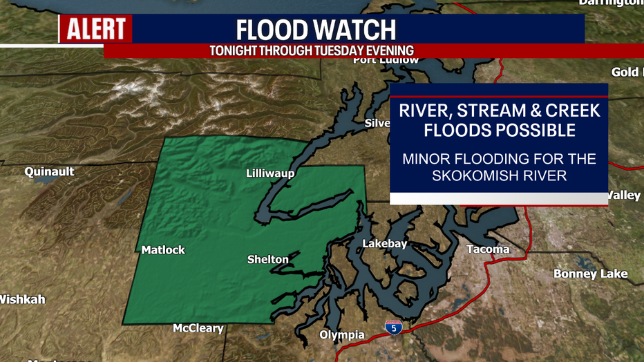
As heavy rain impacts the Olympic Peninsula and the coast, there might be localized street flooding today where downpours develop over areas with poor drainage. While some river levels could be rising, we're only anticipating minor flooding for the Skokomish River in Mason County. For this reason, there's a Flood Watch in effect.
King Tides (super high tides) are expected this week around Western Washington. If you're looking for more information about these, head to this website: https://oceanservice.noaa.gov/facts/kingtide.html
Usually, King Tides on its own wouldn't produce flooding; however, when there's lower-than-average atmospheric pressure and wind, it can create flooding issues. Minor tidal flooding is possible for the Washington Pacific Coast Monday through Wednesday. In Puget Sound, there might be minor tidal flooding Tuesday through Thursday. We're not expecting the flooding to be anywhere near severe as what some communities experienced late last December, but stay tuned for the latest forecast.
For the South Washington Coast, several additional alerts are in effect at times today and tomorrow morning. For the Beach Hazards Statement in effect, sneaker waves are possible. For the Coastal Flood Advisory posted, tidal overflow flooding is expected. For the High Surf Advisory posted, large waves, sneaker waves and hazardous surf conditions are in the forecast. Breakers could be up to 20 feet. For more information, head here: https://www.weather.gov/sew/
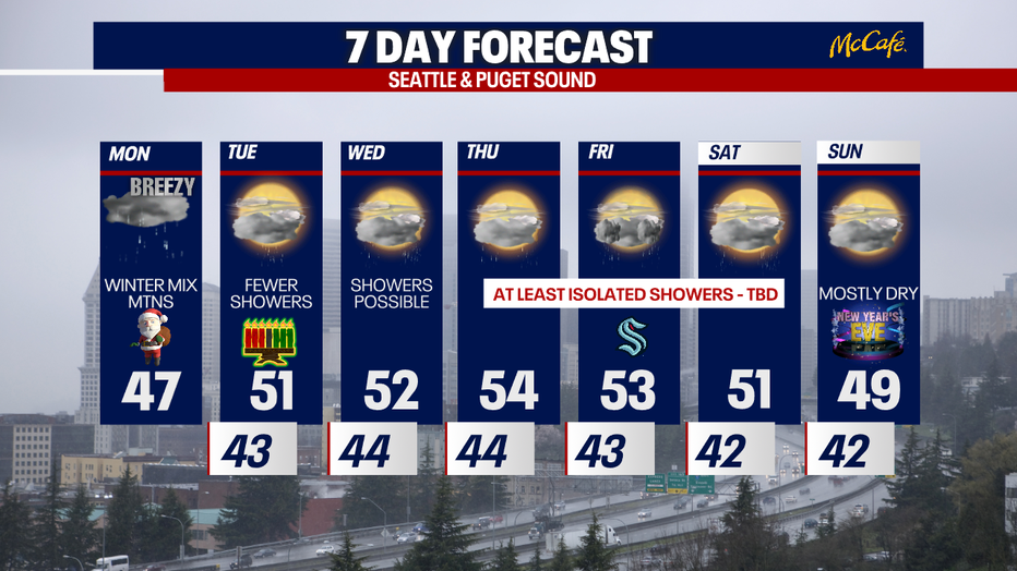
A few showers could linger into Tuesday, but tomorrow should offer at least several hours of sunshine before the clouds return tomorrow afternoon. There's another chance for light freezing rain over the passes Tuesday night.
Scattered showers continue on Wednesday.
Thursday through Saturday, there's still uncertainty about how rainy (or not) it could be around Western Washington. The forecast models we look at to analyze the weather are a bit split on what to expect. However, it seems like New Year's Eve could be mostly dry which is great :)
Thanks so much for choosing FOX 13. We're thankful for you! Have a very merry Christmas.
Take care,
Meteorologist Abby Acone
Follow me on X @abbyacone, Instagram @abbyaconewx, TikTok @abbyaconetv and Facebook (Meteorologist Abby Acone)