
So… What is a Watershed, anyway?
Watersheds are defined by higher peaks and elevation in the landscape, and by the movement of water among landscapes.
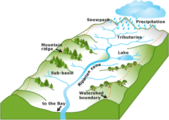
Watershed diagram
When precipitation falls to the ground, it is the area of land that absorbs the water into the ground (groundwater) and also “sheds” or drains the water to lower elevation through rivers and streams (surface water).
Watersheds describe how units of land are connected by water flow.
Headwater watersheds are the most upstream watersheds that transform precipitation (rain, snow, sleet, anything that falls from the sky) into streamflow which eventually connect to larger bodies of water such as rivers, lakes, reservoirs, catchments, wetlands and, eventually, the ocean.
Headwater watersheds are often forested (or once were prior to agricultural expansion). As water naturally travels through the headwater watersheds to the flood plains and valleys, it erodes the surface it is traveling on, taking with it large amounts of sediment, metals, and other compounds that it comes into contact with.
A useful excerpt from the USDA handbook on stream restoration:
““ Watersheds are nested within one another, with larger watersheds composed of many smaller tributary watersheds, and these smaller tributaries drained by even smaller intermittent channels, ephemeral channels and rills. Watersheds are comprised of a mosaic of soil types, geomorphic features, vegetation, and land uses. If a watershed is divided into uplands and stream corridors, the uplands comprise most of its area (in most basins). Upland features control the quantity and timing of water and materials that make their way to the stream corridor. The environmental conditions of the stream corridor (such as water quantity and quality, riparian function, and fish habitat) are, therefore, linked to the entire watershed, and these linkages go both ways. For example, animals living primarily in upland habitat frequently rely on stream corridors for movement, food, cover, and water. Although stream project designers may have little or no control over how a watershed is managed, their plans and designs still should consider the past, present, and future status of watershed land use and historical watershed conditions.”
The Lake Helena Watershed is located in Lewis and Clark (68%) and Jefferson (32%) counties, within the Upper Missouri River Water Basin, encompassing 402,000 acres. Within the Lake Helena Watershed are the Silver, Tenmile and Prickly Pear Creek sub-watersheds.
The headwaters of these streams lie within the mountainous, forested lands of the Helena National Forest along the Continental Divide and the Elkhorn Mountains to the south.
All streams and connected groundwater systems within the watershed eventually make their way into Lake Helena and then the Missouri River, passing through the Helena Valley on their way. Lake Helena formed after the construction of the Hauser Dam, which flooded the wetland area where Silver, Tenmile, and Prickly Pear Creeks converged.
The Lake Helena Watershed is a large and geologically complex area. Both natural and man-made environmental impacts vary across the watershed. These impacts vary depending on the geology, vegetative structure and climate (natural impacts), as well as the intensity and complexity of both historic and current land use practices (man-made impacts).
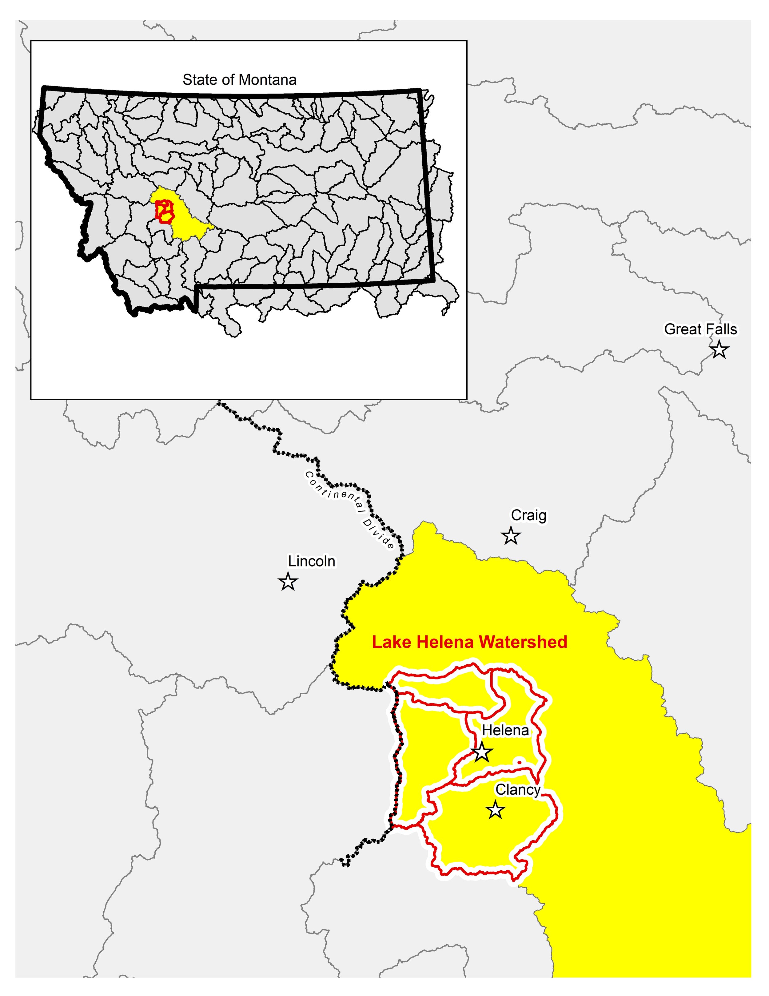
Lake Helena Watershed (HUC 12) nestled within the Upper Missouri Sub-Basin (HUC 8: 10030101)