

Land Use and Social Dynamics in Early 19th Century Bova, Calabria
Department of Sociology and Anthropology, Institute for Core Studies, St John’s University, Queens, NY 11439, USA
Land 2022, 11(10), 1832; https://doi.org/10.3390/land11101832
Submission received: 15 September 2022
/
Revised: 3 October 2022
/
Accepted: 8 October 2022
/
Published: 18 October 2022
(This article belongs to the Special Issue Land Use in Archaeology)
Abstract
:While interest in land use in the prehistoric periods in Italy has received attention, that cannot be said of the Post-Medieval period. The general view is that all activities and objects from the last 300–500 years or so are so indecipherable from their contemporary counterparts and that there is no need to study them. There is, in fact, very little Post-Medieval archaeological work done in the south of Italy, which is the focus of this paper. The landscape of southern Calabria has changed radically over the centuries. The distribution of dense macchia forests was diminished in the late 18th and 19th centuries for building railroads and ships, and more recently, arson has been used as social or political revenge. The removal of the macchia led to erosional landscapes and the loss of archaeological footprints. This paper explores agricultural practices and forest exploitation in the early 19th and 20th centuries by the citizens of Bova to better understand the social and economic dynamics that continue to influence the lives of people living in the community. It utilizes cadastral records, archival documents from the early 1800–1900s, and spatial analysis to better understand the potential economic and social dynamics in this community. Consideration is also given to how social status and power, represented by Church-owned vs. lay citizen-owned properties, was reflected in local land use. The overall paucity of archaeological materials from this period across the landscape supports and complicates the overall picture while also supporting an interpretation of a very local and insular community poorly integrated into the greater Italian economy of the day.
Keywords:
land use; archaeology; economic botany; Napoleonic period; social dynamics; Calabria; GIS; spatial analysis1. Introduction
Historical archaeological research in southern Calabria is still a relatively new area of study. For local citizens and scholars, the continuation of many agricultural and social patterns over the last two centuries has led to a lack of appreciation for historical studies of this period and, in particular, for archaeological work. There is a scarcity of archaeological and empirical data about the use of the land, the crops grown, or the relationships of the upland communities to the greater economic systems of the time, particularly in the early 19th century. While historians have looked at the social institutions connected to land tenure and political changes in this period, archaeologists have not attempted to bring together the archival and artifactual data in the same manner here as they have in other areas [1,2,3,4,5]. During the period of Napoleonic Rule (1807–1816), a brief period of French colonial influence in an otherwise Spanish colonial context (first Spanish Bourbonic period 1734–1806, death of Murat 1815 (French rule), return to Bourbonic rule until 1859; 1860 unification), the hill town of Bova (Calabria, Italy) was situated in an environment of abundant natural resources, long-standing ties to religious infrastructure, and a citizenry with multiple professions. Despite this, recent research has shown that the community was not fully integrated into the larger regional economic system of the Kingdom of Naples, other areas of the Italian peninsula, or the larger Mediterranean world. The years between the great Reggio earthquake of 1783 and the arrival of the French were marked by multiple depredations, both natural and economic, with famine, disease, and riots. These came in waves or clusters, as did revolutions and changes in political regimes. This paper investigates how this landscape of natural and political uncertainty affected the economic strategies and social relations among its citizens through evidence left in the archaeological record and considers the impact of those events on more contemporary practices.
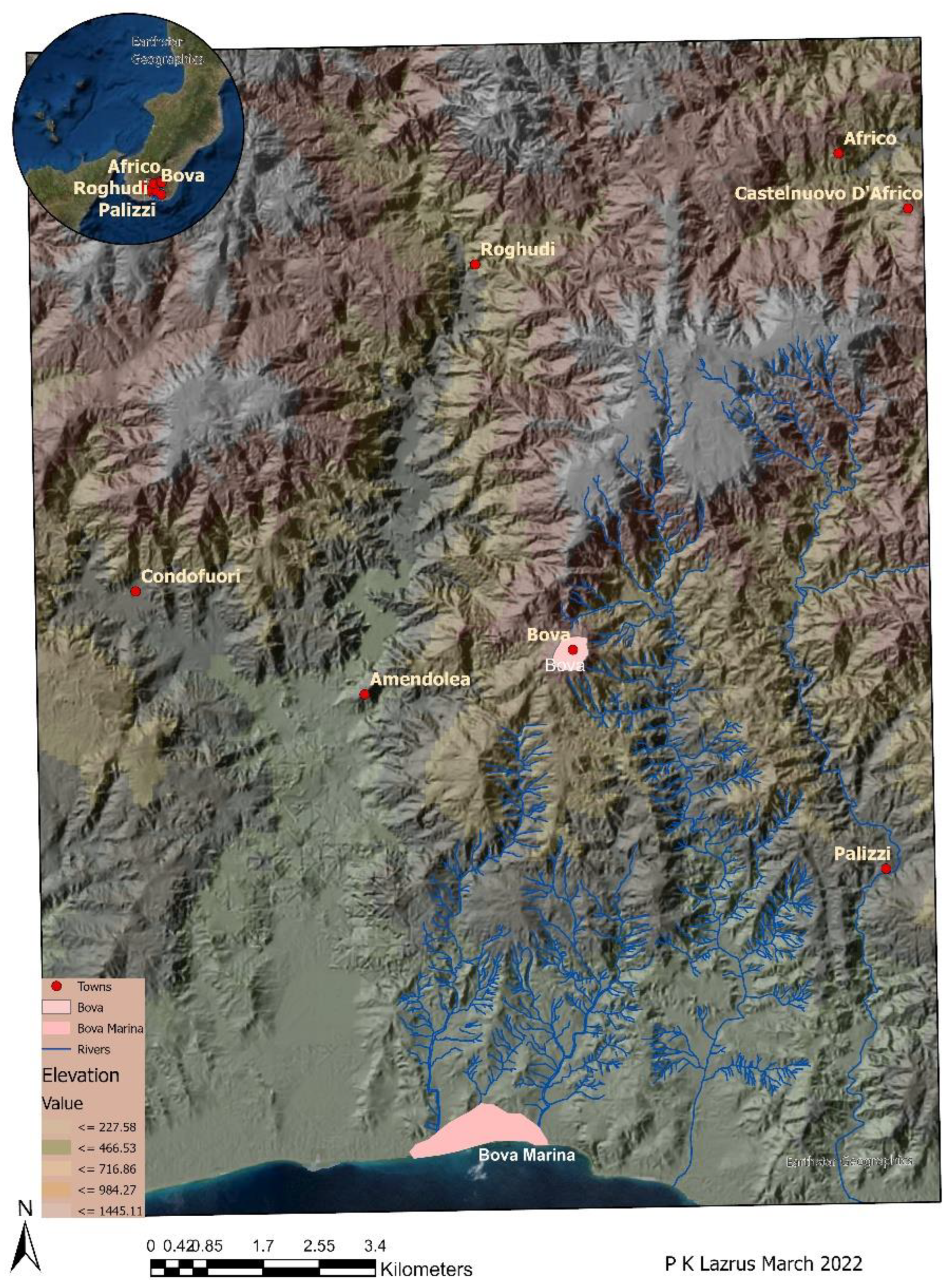
Bova is located in the southern foothills of the Aspromonte, the mountainous southern tip of the Italian peninsula in the region then called Calabria Ultra. Difficult to reach over land and without a deep harbor, Bova was situated on the margins of the Kingdom of Naples; it was a small but rather stubborn and independent community [6].
The town sits on a hilltop at 915 masl overlooking a series of ridges and valleys that extend southwards to the sea and across inland plateaus to the north that stretch deeper into the heart of the Aspromonte (Figure 1). The town, once the feudal property of the archbishop of Reggio, and a bishopric in its own right, was a small but important community in an area poorly integrated into the larger economy because of the lack of investment by the government in Naples with larger political issues on its mind, and the community’s own desire to be left alone by those same forces [6]. This tension led to a small-scale, localized focus on landholdings without the implementation of intensive strategies to increase production. It is arguable that similar sentiments influence economic and political choices even in our contemporary context.
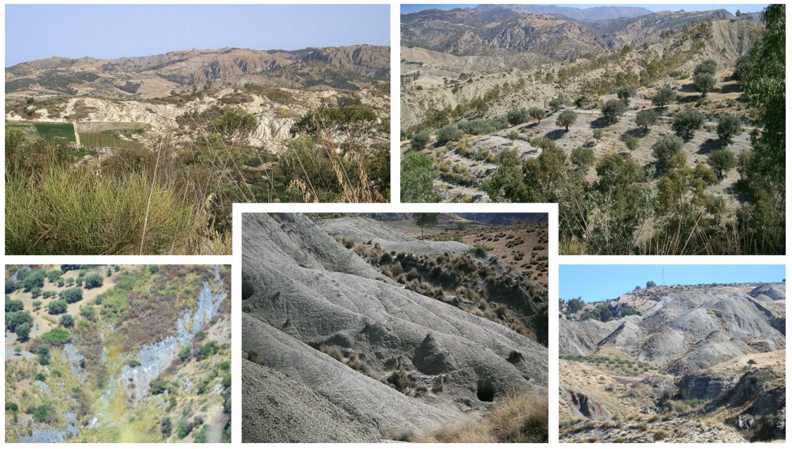
The vegetation we see today is reduced in extent and biodiversity compared to that described in traveller’s texts from the 1500–1800s, maps, and archival data on the management of forests as late as the early 20th century [7,8,9,10,11,12,13,14,15]. All describe an environment with thick macchia or forests with a wide variety of trees, both deciduous and evergreen. The contemporary landscape contains remnants of these forests but is generally a landscape of newly planted fields or hills that have been denuded down to the clay horizons. In the higher elevations to the NE of town, reforestation projects have replanted tracts with single species of pine. Many of these emerging badlands areas were covered with century-old trees and brimming with diverse resources [4,16,17,18,19,20,21] that are no longer available. While there are some scholars who question this image of a vastly altered landscape, documentary records for this area support the claim that this was once a more verdant landscape than the one we are familiar with today [15,16,17]. It is in the context of this resource-rich, politically, and seismically unstable environment that we must evaluate the economic and social situation of the inhabitants (Figure 2).
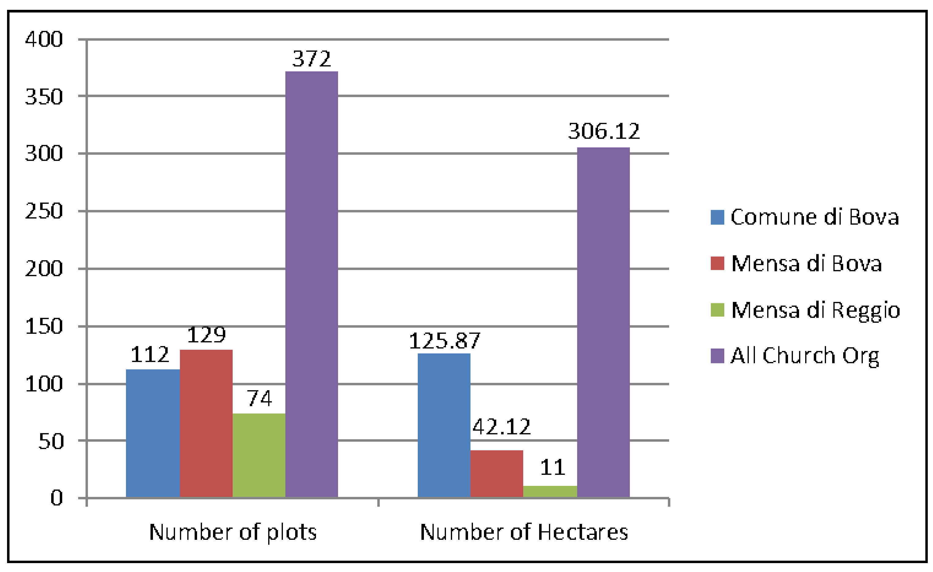
Unlike other areas of southern Italy, both within Calabria, in Puglia or Sicily, there are no large estates (or at least none with contiguous expanses of property) owned by landed gentry within this community. The largest tracts of land owned by a single individual are just over half a hectare, while the Church has tracts as large as three hectares, with the most extensive plots identified as sterile/uncultivatable [22]. Before 1783, the Church was the feudal landholder, but after the calamity of the earthquake, Church lands and goods were expropriated, and the funds were used to create the Cassa Sacra. The purpose was to finance rebuilding, but in practice, little was paid for, and apparently, much of the land was reacquired by the former owners in this area. The largest plots held by the municipality of Bova were also identified as sterile [22] (see Supplemental Files Table S1 for individual tax data, Table S2 for organizations that were taxed, Table S3 for agricultural artifacts).
To investigate how the land was used differently in the past than it is currently, data from the cadastre of 1807 were entered into a database, and then, where possible, named localities were matched to maps of different scales and then plotted in Arcgis. The underlying function was to provide general information on what the landscape could support, what areas were dedicated to specific crops, and how that might differ from what we observe today. The results were analysed to identify connections between owners of potentially different economic classes (identified in the cadastre as part of an individual’s name and possibly through artifactual remains found in the landscape) as a proxy for understanding which citizens had access to potentially favorable areas and as a guide to better interpreting the artifact distributions from our archaeological field surveys. Of course, in this local economy, organic materials were extremely common and would, of course, leave little trace in the landscape even while appearing in the archival documents. The results of this spatial analysis provide insight into the land use practices in this area in the early 1800s and provide a greater understanding of how the land was used then compared to the present day.
An examination of who grew which crops and where those plots were located tells us something about land use but also about access to different terrains [23]. This was a dispersed system of landholding where citizens privileged the ownership of many small plots in various zones (with differing elevation, drainage, sun exposure, and access to trails). Many citizens owned some land or structures, but the Church and the municipality were the major landowners, along with a few doctors and lawyers. Attempts to widen access to land ownership were not particularly successful in this area. The result left the Church and its dependents in possession of more of the land than one might otherwise presume, given the earlier Jacobin push for change in the period preceding Napoleonic rule. It might also be seen as a tangible reflection of the failure of all the movements for change in the period on either side of Napoleonic rule [7] (pp. 92–95), [24] (pp. 26–33). Even among the rising middle class, there were few who were benefiting from the new opportunities for ownership, and these relationships played out across the landscape in terms of where land was owned and what kinds of crops were grown.
Archaeological and archival records can be useful complementary resources, but each is incomplete in some fashion, and thus, challenges continue in our capacity to fully understand how the landscape was used over the last two hundred and twenty years and how it has changed. This work makes some headway in understanding these changes.
2. Materials and Methods
Archival data, primarily from the early 1800s, GIS modeling, and archaeological field surveys have been used here to evaluate the economic impact of crop location on economic and social status. The documents available vary in depth and detail but include tax records from 1742 (Catasti Onciari), 1807–1808 (Catasto Murattiano), and 1822 (Stato di Sezione), as well as a wide variety of legal documents, personal papers, and maps now kept in the state archives of Reggio Calabria and Naples and the Instituto Geografico Militare (IGM) in Florence [22,25,26]. In terms of this analysis, the focus is mostly on the Catasto Murattiano, which reflects a snapshot of the situation during the Napoleonic period, although the document was never formally validated before the Bourbons returned to power. While this document captures data from a particular moment in the early 1800s, it is useful for understanding land use because it is the first document in the region to list individuals and what they grew by locality.
The Catasto Murattiano was the first attempt by the Kingdom of Naples under the rule of Gioacchino Murat to catalog all that was now in his possession. Each municipality was required to list all the citizens by name (which also usually included profession), where they were from, if not from the town of Bova, and where they held property (either land, crops, or structures). Each entry was tied to a locality and the extent of terrain, its quality noted, and a calculation of the taxes owed listed. This information was entered into an Access database and then extracted for spatial analysis.
The data were mapped (in part) against artifacts collected from a field survey conducted by the Bova Marina Archaeological Project (BMAP) between 1998 and 2014. Mapping the cadastral data proved particularly challenging as there are no extant maps that include property boundaries for Bova until 1932—a fact bemoaned by Napoleonic ministers in 1806 [7] (p. 181), and the earliest IGM (then called the Instituto Topografico Militare) map focusing on the area at 1:50,000 is from 1870, nine years after unification [27]. It is this map on which many later 20th-century maps are based, but neither this nor the later maps contain many of the place names identified by citizens as localities where they held property. Of interest, however, is the statement on the 1870 map that no regular maps were available for the period prior and that that map was made in a hurry to have a proper working document of the area [27].
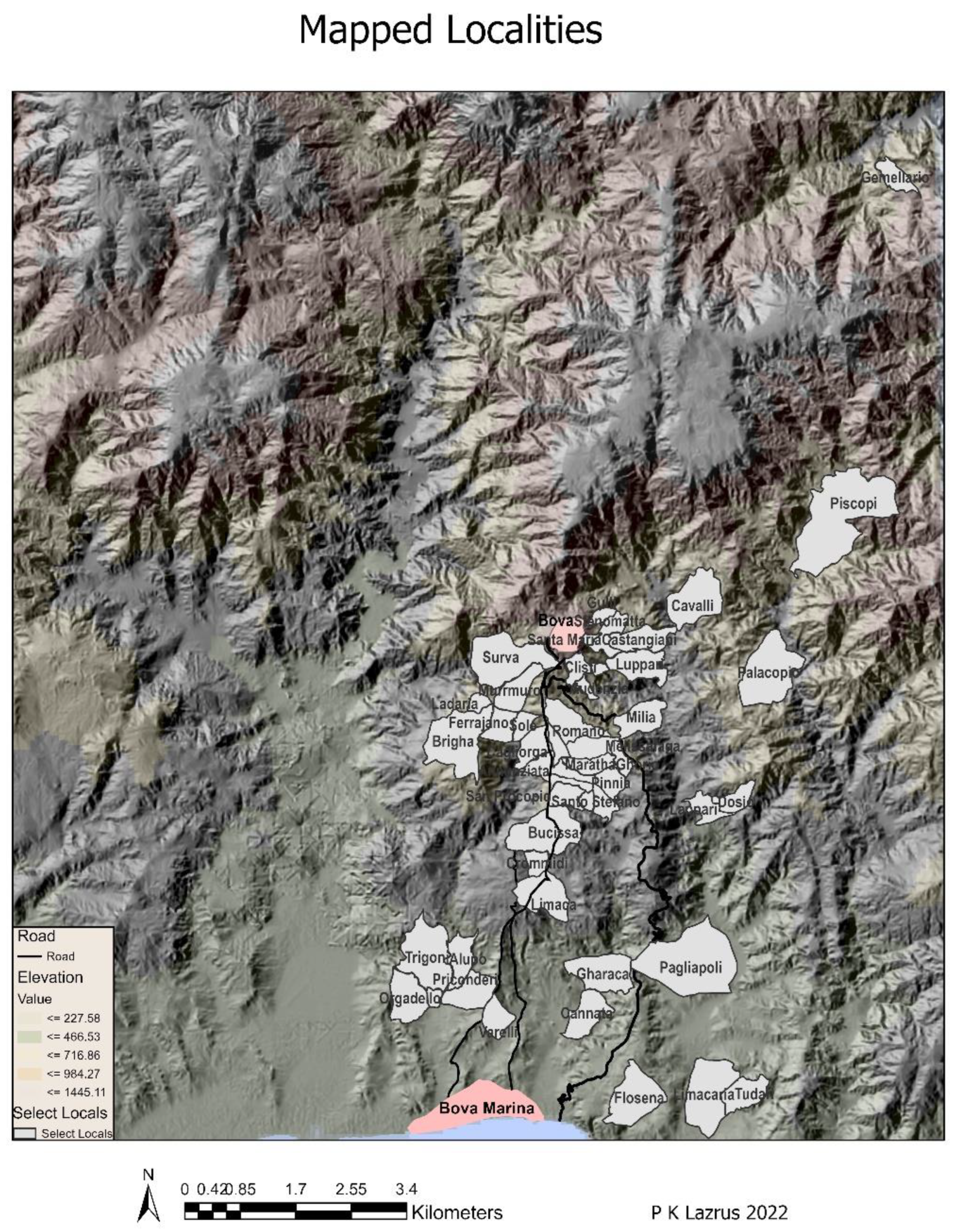
To perform the spatial analysis, all localities listed in the cadastre were entered into an Access database and then checked against maps of diverse scales (1:50,000–1:10,000) dating from 1870 to the contemporary period. It was possible to identify with some degree of confidence 40 localities which were then digitized as polygons in Arcgis (Figure 3). The individual property boundaries from 1932 were used as guidance to clarify the potential locality boundaries in earlier periods where there was consistency in local names. While not ideal, this at least allowed for the mapping of sample areas with attributes for owner, crops, or structures. Diverse spellings of locality names and multiple names for the same spots presented further challenges, a situation that continues when interviewing current residents of the area for topographic information. A final challenge emerged in terms of more precise information about where individual plots were located within a given locality. We know who owned the plots, how big they were, and what was grown on them but not where precisely they were located within a particular locality.
Field survey and excavation have been an integral part of the BMAP project since its inception in 1998. Initially, the focus was directed exclusively on the prehistoric periods, but it was soon expanded to encompass the Classical periods and subsequent history, both Medieval and Post-Medieval, although the latter is represented only by field survey. In the earliest years of the survey, we were not as practiced in identifying features such as threshing floors, nor were we always consistent in the attention to and collection of Post-Medieval materials. That said, where possible, this information is integrated into the work presented here.
For the Medieval and Post-Medieval materials, this means that there was not a coordinated or systematic collection of artifacts or signaling of structures related to this period. As a result, while analysis is still ongoing, the correlation between field and archival data is not as tight as desired.
3. Results
3.1. Topography and Resources
The general erosional nature of the landscape posed the initial challenge in identifying indicators of land use from the period under consideration. Pluciennik et al. conducted one of the few historical archaeological studies in the south of Italy, focusing on 18th and 20th-century rural Sicily. They note that in their research area, post-WWII damage made landscapes harder to read with loss of background scatter [28]. Bova Marina was bombed during the second world war, and RAF photos of the Bova/Bova Marina area taken during WWII show many denuded slopes that would potentially contribute to the removal or dispersal of smaller artifacts. This erosion clearly complicates efforts to clarify land use in this period through archaeological field surveys.
Pluciennik et al. also noted in their work that most people lived in villages and towns and traveled as far as 15 km to and from their fields [28]. That pattern is also true here in the Bovese. The farthest linear distance from the town of Bova is to the village of Africo, and that is nine km, as measured with GIS linear distance tools. The actual distance is longer because of the hilly nature of the landscape. For example, the linear mapped distance from Bova to Bova Marina is 7.14 km, but the state road that connects the two towns is 14 km. The cadastral records indicate that most citizens of the area lived in the town of Bova, and those who did not were most likely to live in the dependent villages of Casalnuovo di Africo or Roghudi (Table 1).
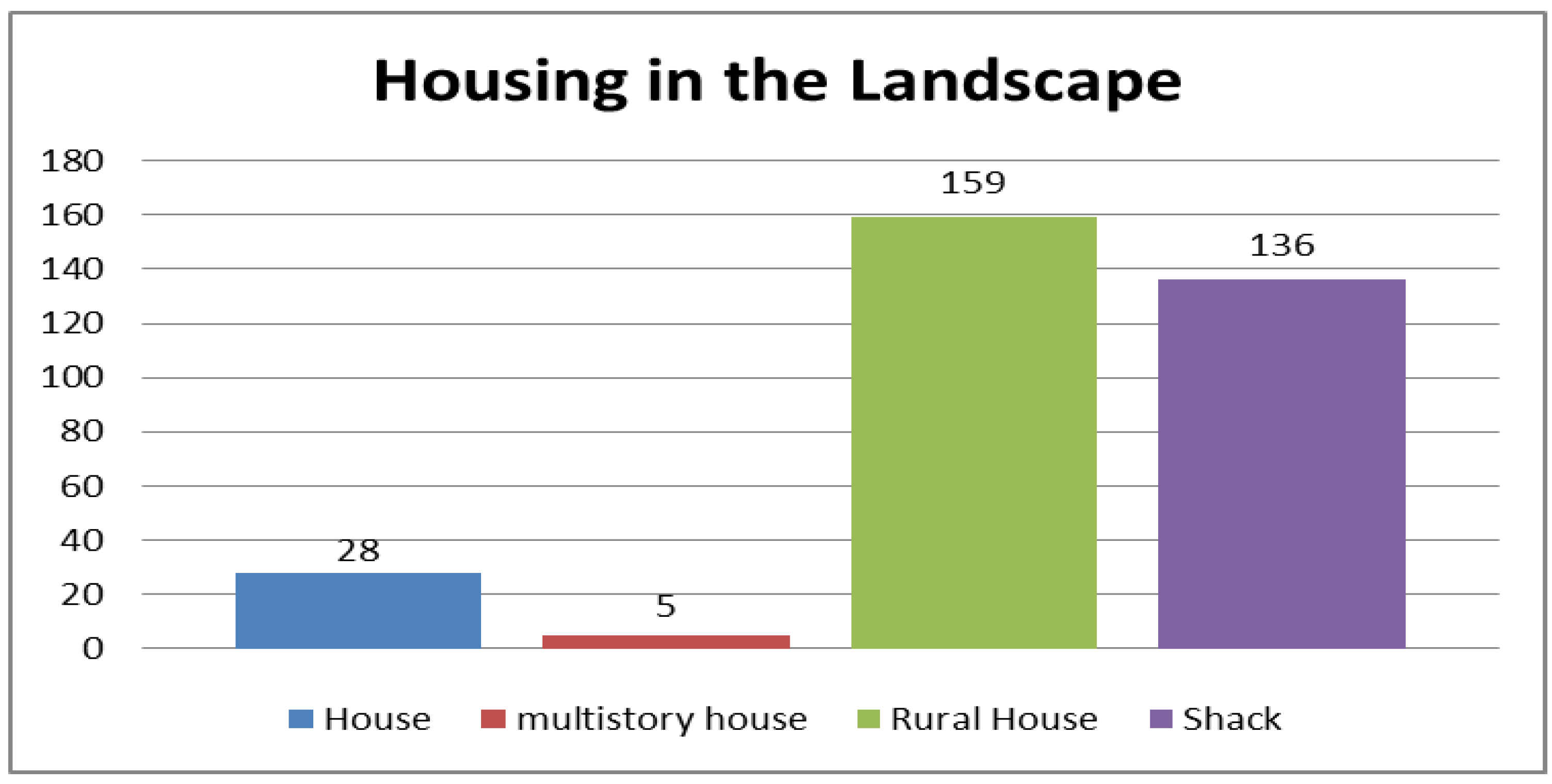
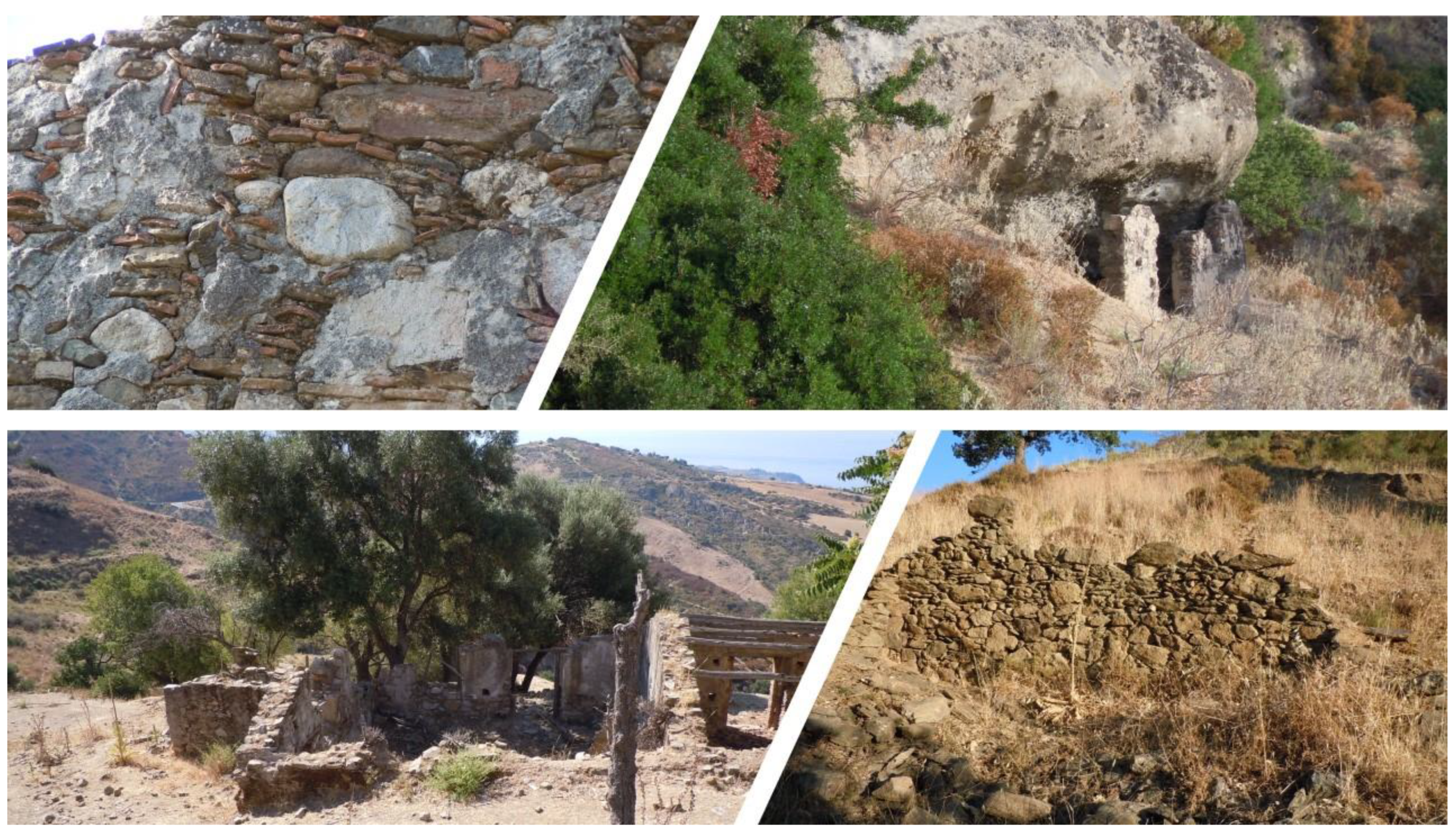
In the early 1800s, few citizens lived independently, isolated in the countryside. Some folks may have slept out in their fields during the week in animal shelters, rural homes, or rock shelters. We have found examples of all these buildings during surveys even if we do not have the dates for them [20,21,29] (Figure 4 and Figure 5). Many of these buildings have remained in use over generations going through phases of abandonment and restoration but remaining in an extended family’s possession. This, too, is a complicating factor. If a building from the seventeen or eighteen hundreds is abandoned and reduced to its shell or foundation but has not been excavated, then it is more difficult to build a chronology of field shelters. Because it is easy for current residents to say a structure is not old, it will then not receive the archaeological attention needed or the permissions to excavate it.
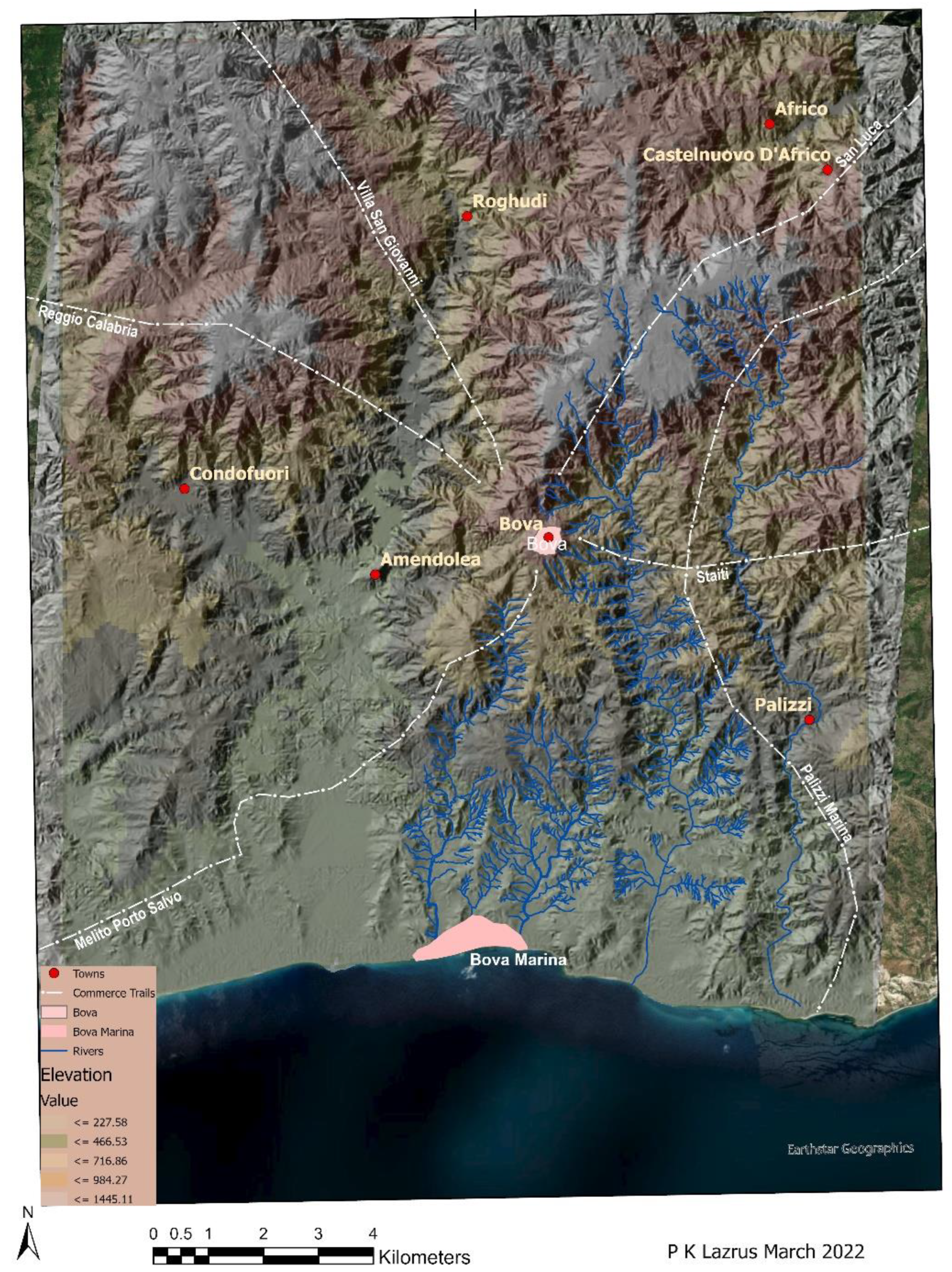
Bova’s harbor was not deep, but the beach was used to pull up shallow draft fishing boats and for travel up and down the coast to neighboring communities, as is still the case. The largest port nearby would have been Melito Porto Salvo, and a map of commercial trails from 1871 indicates that the only track from Bova to the local coast connects these two communities (Figure 6) [30,31].
Only one citizen is listed professionally as a sailor, but many people could have owned small boats kept on the beach, although there was no town on the coast until after unification. The community of Bova Marina was not established until a decade after that. The lack of a deep harbor might not have been a negative for 19th-century Bovans, as unloading large boats in deep water and using tenders to shuttle goods to shore is a long-standing tradition in many places, including Naples, as demonstrated in paintings and illustrations on ceramic tiles from the period. Fishing and shipping appear to be subsistence activities here, especially in the earlier years when there was no permanent community on the coast.
Commodities were transported from Bova by mule inland across the lower reaches of the Aspromonte. These internal routes connect Bova to communities such as Reggio, Staiti, Calanna, San Luca, or Pedavoli from where the goods could continue to other coastal areas at a time either before the railroad or while it was being constructed [32,33].
These were the main commercial connectors well into the early period of train travel in the early 20th century. The hilly and mountainous terrain, broken up by seasonal streams, both large and small, made for difficult travel conditions to and from landholdings as well as to/from markets both near and far. Systems of foot and goat paths supplemented the single main tracks between the town and the coast [23,24,34]. Complicating matters was the Napoleonic directive to blockade goods destined for British markets and the requirement that silk thread and olive oil (which was used to make soap in France) transit through Naples [7]. This, of course, influenced what people would have grown and how integrated they were into the larger economic systems of the day.
3.2. Land Use
Despite the confiscation and sale of Church lands after the great quake of 1783, archival and cadastral records demonstrate that institutions (the Church and municipality) and a few individuals held more land than the rest of the citizenry, although it is only possible to map a sample of the holdings at this time (Table 2). We do know, however, that these groups held many plots across a greater number of localities and that the dispersion of holdings across the landscape was the preferred risk management choice. Today, where farmers have consolidated their holdings, the risks from road constructions, floods, landslides, drought, or pests threaten many individuals despite their more extensive holdings.
There seems to be little economic interaction with the larger sphere represented by Reggio, Naples, or Sicily in terms of contracts for goods shipped out from Bova in the notarial records or diaries or in terms of items such as ceramics from regional factories. Neither have we found much evidence for personal items during our surveys (or excavations that focused on earlier prehistoric and historic periods). Even the Church, the wealthiest landholder, is not represented in terms of potential artifacts that one would otherwise expect to see in the landscape. Considering that aside from the churches in town, there were saving associations (essentially pawn operations), seminaries, and other related structures, we found no explicitly ecclesiastical remains (whether pieces of reliquaries, sacred objects, or liturgical adornments) among the items we have identified.
The one exception to a tangible reflection of economic growth was perhaps the establishment of the town of Bova Marina itself, founded in 1870 by Bishop D’Andrea of Bova as a community for struggling fishermen [30]. The town would only become officially separated from Bova in 1908, but it soon flourished with the opening of the railroad and is now the larger of the two municipalities.
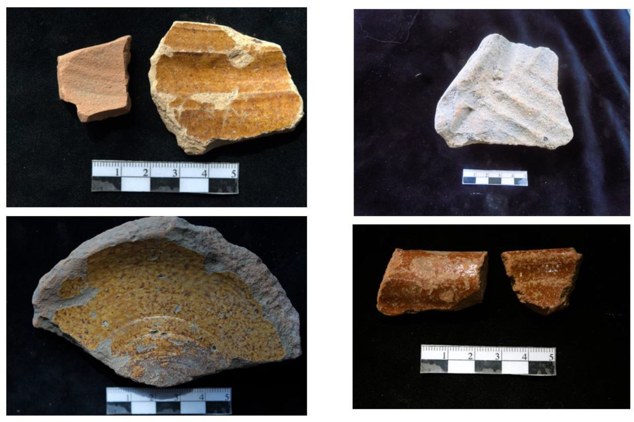
Marriage contracts and other notarial documents spell out items that were exchanged between families and include items such as linens, bedsteads, and copper pots, but we do not find references to many imported items. The only place these objects appear is in the documents regarding items that are used as collateral for loans through the Monti di Pegni [35,36]. Those documents do mention rings and copper pots, blankets, and the like, providing a window into what was valuable to citizens. Unfortunately, many of those items are organic in nature and will not leave an archaeological trace on the landscape. Most of the ceramic finds represent locally made common cooking ware and water jars also found in comparable work in Sicily [28] (p. 114) (Figure 7).
The only maps available prior to that of 1870, mentioned previously, consist of small colored sketches inserted into legal disputes over property ownership/damages, and they do not provide indications of specific crop species even when arguing that someone has not properly tended, harvested, or turned over what was due. For example, the reference might say grapes, but whether wine or table or the species, there is no way to know. Other personal legal documents, such as those involving inheritance or gifts, occasionally mention items that might remain in the archaeological record. That said, items like hand-carved wooden bodice stays (a traditional gift from groom to bride), cheese stamps or textiles, bedsteads, and storage chests, would not be preserved except by families that might still have heirlooms and yet they would have been items of real value to the owners.
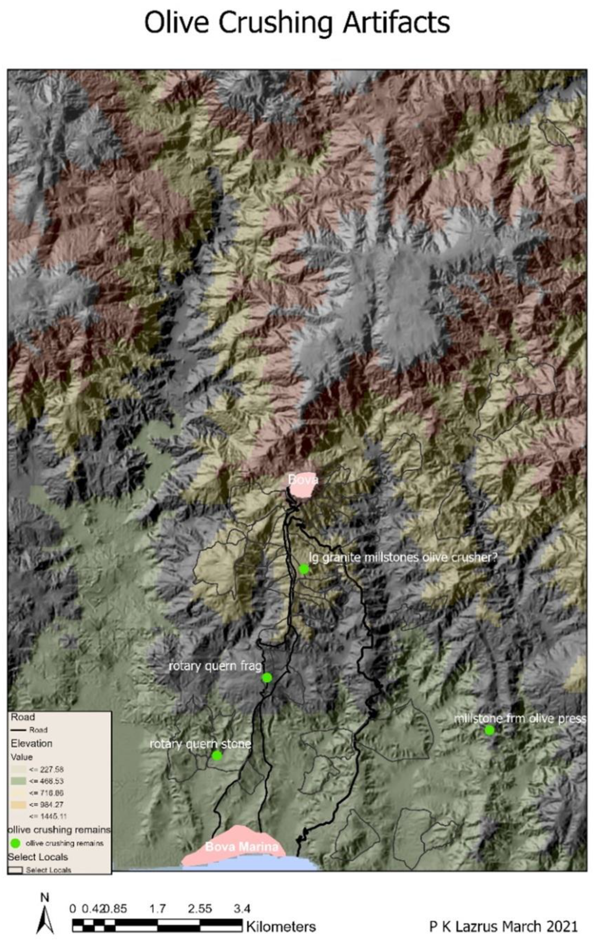
Calabria Ultra’s major exports were textiles, olive oil, and silk thread. Until 1815, silk thread was heavily taxed by the government in Naples, which discouraged newer, more efficient methods of spinning the thread [7], which by law had to be shipped from Naples. As these are organic commodities and, except for oil, might not be shipped or stored in ceramic wares, traces in the archaeological record are harder to find. One would expect to find spindle whorls, shuttles, or spinning wheels, but these are generally made of wood and are often kept in families for continued use or left in the attic. We have records of apparatus for squeezing water from silk threads but not of silk manufacture from this period because it was the thread that the French wanted for their own fabric makers. What we do have, is the record of how many mulberry trees were taxed to different citizens or how much land was planted with olives. The oil could easily have been conveyed in what we consider water jugs, but since we only have fragments (often rims, body shards, and handles), it is hard to assess what these common jugs held. We do, however, have documentary evidence for three oil presses, and there are quite a few to be found in local collections, even if they lack origins. Olives are among the crops taxed, and we have identified some artifacts as being utilized for olive crushing (Figure 8 and Figure 9).
The colonial government in Naples apparently did not think this area was worth investing in despite its rich resources, and the citizens appear to have accepted this disinterest, not having protested it or made claims for better services or treatment. We have located several oil presses during our surveys, but again, we have no precise dates for them; thus, it is difficult to make matches with the documentary records from the early 1800s. A report for administrators in Paris on conditions in the Kingdom of Naples from this region noted that the people lived off very little except in the capital (Naples), and Swindburn in 1783 records that people had a hard time growing enough to eat [37].
With regard to the Napoleonic tax records of 1807 and the Bourbon records of 1822, we can see differences in how the land and its produce were evaluated for tax purposes. The great Napoleonic reform transformed the existing Bourbon 1742 Castasto Onciario, which utilized a head tax to a proportional land tax (Figure 10, Figure 11 and Figure 12). This was meant to equalize taxes and was a challenge for the new colonial power as there were no property surveys at this point in the region [7]. It was the new administration’s thought that this change in taxes would move the kingdom from an agglomeration of individuals and turn them ‘into a people’ [7] (p. 175). The Catasto Murattiano represented a preliminary attempt to assess a new empire’s resources, even though it was quickly superseded in 1822 by the restored Bourbon government’s Stato di Sezione. In the first instance, the state was now asking each citizen (by town) to list what they owned and where. Each individual taxpayer listed the crops grown in hectares (or portions thereof) and land type (in terms of perceived productivity). When things swung back to Spanish control, the restored regime did not return to the old head tax system, rather, they applied French reforms as part of wide-ranging new legislation meant to simplify the system [26,38] (pp. 91–93). There is a shift to greater systemization of terms for crops. For example, in the Catasto Murattiano, individuals might list a plot as containing almonds and fruits, another as nuts and fruits, or a plot as sterile, and another as of inferior quality. In the Stato di Sezione, there were set categories.
The boundaries of each of the eight sections (neighborhoods) were labeled A–H, with H referring to the town proper. The letter and boundaries are described at the head of each section’s submissions. They use natural landmarks to define the boundaries of each area (for example: go up and across the ridge and down the valley of X, etc.). At the end, there was a summation of that section’s contribution, and each category of crop or land type was clearly listed. All categories did not necessarily appear in each section, but the terminology remained consistent [26]. This gives us some insight into their perception of the land quality and use and is especially important for understanding the laborscapes and taskscapes.
Some understanding of land use can be extracted from the terms people used to denote what they were growing. Many of the plots that were planted were mixed/intercropped. This is evident in various descriptions of what is being grown. Semina di mezzo, the category utilized in the Catasto Murattiano, for example, refers to grain sown between fruit trees, grapes, or olives. Crops are identified by general type, not by species planted. Many plots are listed as containing nuts/fruits, nuts/grapes, etc. There are seven categories for grains, of which two refer to plots where grain is intercropped with either mulberries or other fruit trees [25,26]. Presumably, rye was grown in the upper elevations, but it is not specifically identified. “Semina di marina” is possibly a reference to barley [25] and was widely grown. Grain grown in enclosed plots (chiuse) was listed separately, and it is of interest as it is directly tied to the attempts at greater privatization of the land [7,38]. There were no other walled fields.
Within the municipality, 299 fields were designated chiuse across 100 different localities. The average size was about 0.488 hectares, but four clergy members had chiuse of more than one hectare, and among the rest of the population, 35 people did. Three had two-hectare plots. Among those three, the owners included lawyers and farmers, the latter perhaps in a tenant relationship but still having to pay the taxes. Our three wealthiest citizens own 25.47 hectares of chiuse between them, or about 35% of the hectares owned by non-clergy. Only Giovanni Battista Panaghia owns a chiuse of just over two hectares. The wealthy Signora Lantana from Reggio also owned two chiuse, one of which is just over a hectare in size.
The Stato di Sezione also had a separate category for grain on an irrigable plot, one for chestnut and oak groves, and one specifically for oaks that were intended for pasture [26]. The church owned many more hectares of barley than other grain (Table 3), the reverse being true for the municipality and the wealthiest group of individuals based on entries in the 1807 cadastre [25]. Of particular interest with regard to both cadastres is the fact that although sheep, pigs, goats, and cows would have been important to the local economy, they are not listed at all, although pasture is. Oaks that were also used for grazing were listed. These represent one of the few explicit references to pastoral activities in the two cadastres from the 1800s examined to date. It is likely that the free form of the Castato Murratiano, while a headache for tax officials in Naples, is an accurate reflection of how the local inhabitants categorized their surroundings and activities.
4. Discussion—The Social Landscape
According to data from the Catasto Murattiano, Bova’s social landscape was a community of artisans, professionals, farmers, day laborers, and clergy. Most individuals list themselves as managers of farms, farm workers, or day laborers. This latter group could work as farm hands or shepherds for others, and they constitute 343 entries. There are 486 additional people without professional identifications who are most likely also day laborers of some kind [25]. This interpretation supports reports from 1863 stating that most peasants were day laborers working other people’s land unless they worked their own, even though they paid taxes on the produce that they grew on the land they worked, whether or not they owned it or directly reaped its benefits [15]. This type of tenant relationship continued in the San Pasquale Valley into the contemporary period, as recent work has shown [38,39].
The way this region and its people have been viewed over the centuries influences our understanding of the region and its development. For imperial governments and their successors, this area has often been seen as forbidding, distant, and underdeveloped. For travelers from the 15th–19th centuries, it represented a landscape of severe contrasts. Most travelers noted the extreme poverty of the inhabitants but lauded the dense and lush vegetation that they wrote made it a ‘paradise’ [8,9,14]. Today many of the same attitudes toward citizens in this area still exist, and questions about how the land is cared for or how resources are extracted remain in tension between Italian citizens living in the north or in the south. We continue to see that citizens in Bova and Bova Marina make economic choices in terms of where and what to plant and what to produce for the market in ways that seem opaque to those living outside the area.
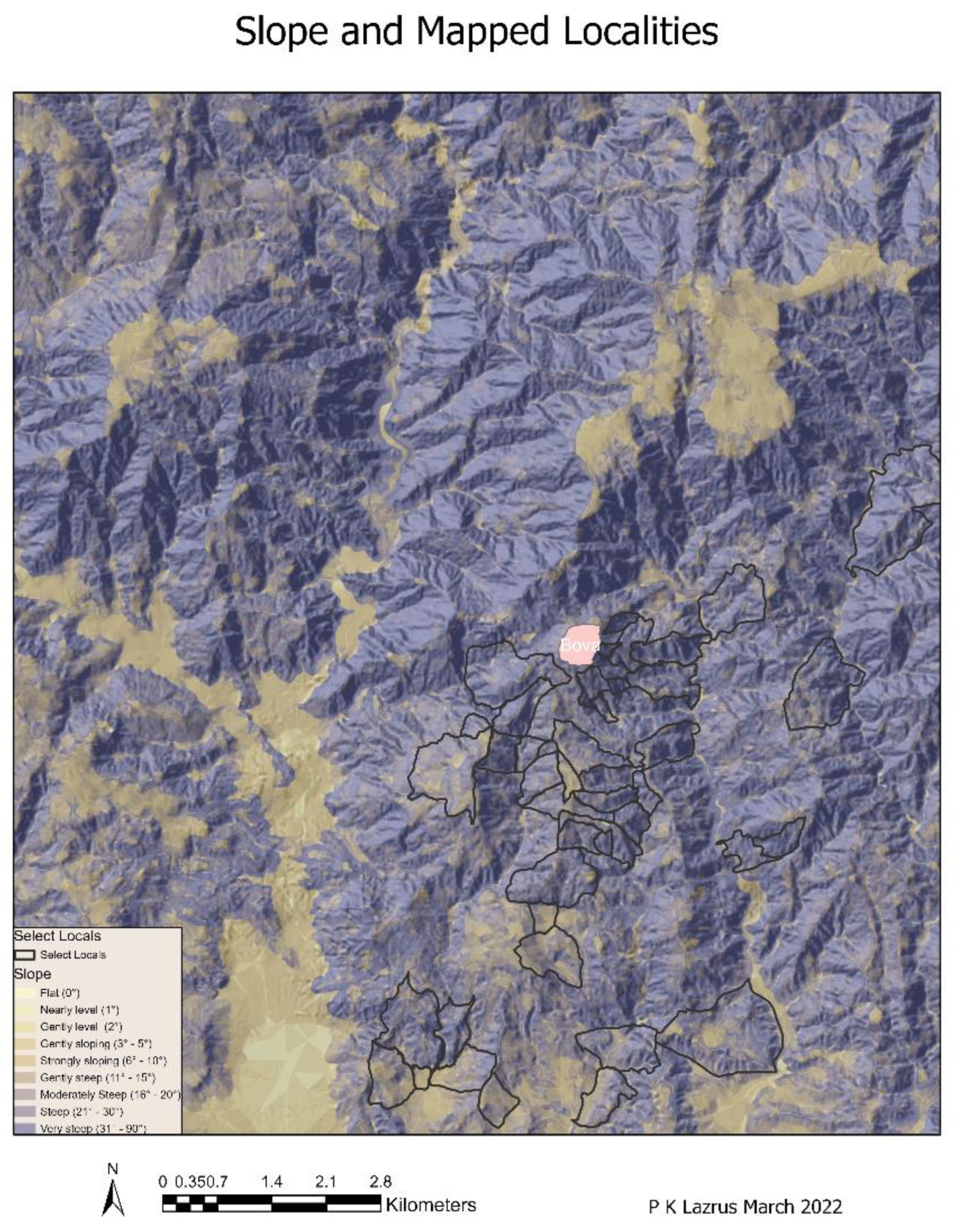
The hoe was the primary tool for agriculture [40]. Everyone was said to know how to use one, although the plow, owned by the town or people of substance, would have been reserved for those with large plots of land [15] (pp. 92, 37, 310) [40]. Plows were likely to be prohibitively expensive to use and thus not affordable for most individuals. The expense lay in the cost of keeping oxen, something that was not within reach of most citizens. Of course, it was possible for the wealthy to rent their oxen out, or even for people with a single ox to pool resources; however, the former was still likely out of the reach of many Bovans. That said, most plots were small, often on slopes of five-eight degrees, but there are some plots on slopes ranging from nine to sixteen degrees. There are fewer plots that we can map on flat areas. Most require travel over uneven terrain (Figure 13).
While mules could also have been used, most of them were pressed into service as pack animals taking produce and goods from Bova to other towns via mountain trails. Several organizations ranging from seminaries and ecclesiastical canteens to the municipality of Bova itself and the Church (both as an organization and as individuals), were also property owners and were the ones most likely to have had both the money and need for the plow as they owned by far the largest parcels of land. This is of interest given that Church property had been confiscated for the Cassa Sacra after the quake of 1783 and was used to pay Kingdom debts. In addition, many churches and church organizations were looted during the political unrest between 1792 and 1806 [7]. This, in addition to intense erosion, might also explain why we have found few church-related materials or what might be termed luxury items. On the other hand, the fact that so much land is held by the Church writ large, it would appear that individual clergy or the internal organizations likely had the money to buy back land that was expropriated.
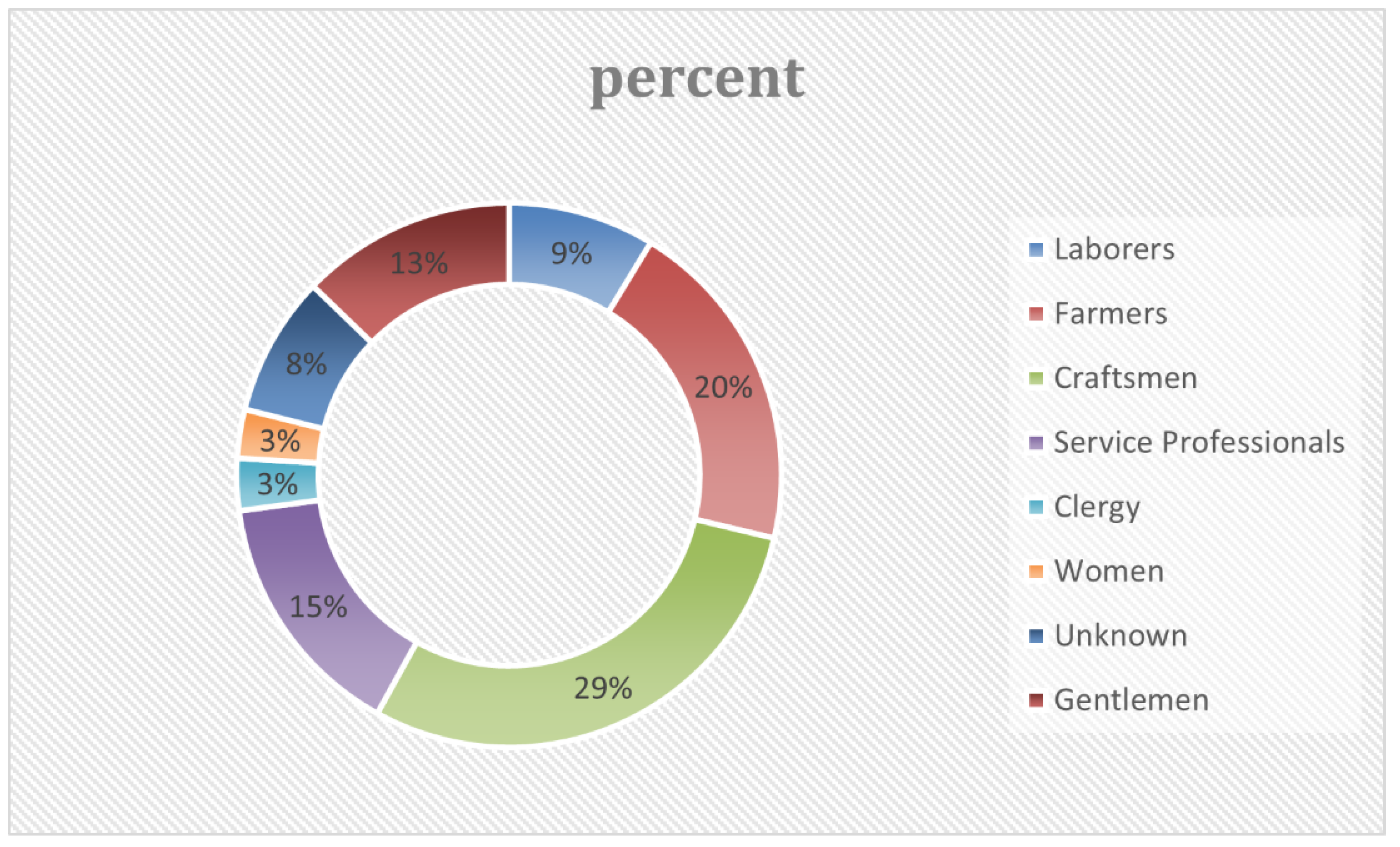
Aside from the above-mentioned groups, there are approximately 47 separate occupations identifiable from the cadastre. These include various categories of church personnel (canon, deacon, priest, archbishop, etc.) that form a sub-group. Women are listed without a profession, although widow is an identifier (Table 4). Of all professions, lawyers and notaries seem to be overrepresented for such a relatively small community, but based on available records, these men were kept quite busy handling a variety of real estate transactions and disputes, and of course, they can write, whereas many citizens were not able to.
Four types of property reflect ‘industrial’ infrastructure in the cadastre: mills, olive presses, a warehouse, and silk rollers. The latter is of interest as the manufacture of silk was mostly confined to towns such as Catania and exported via Naples in other periods. It represents a product of potentially high economic return, especially in the preceding periods, and yet at this time, only silk tread was of commercial interest. There are three machines for extracting water from the silk listed, two of which were likely located in town. One of these presses is jointly owned by a group of four investors, but the others are owned by individuals or organizations.
The presses seem to represent a process that has been ‘outsourced’ to Bova, or they could be local concerns that worked with silk and other local materials. Mulberries are among the trees owned and taxed within the municipality. There are a total of 229.18 hectares grown across 69 plots owned by a total of 40 different individuals, the municipality, and the canteens of both Bova and Reggio. The largest ownership of mulberries was by an individual who owned 15 hectares divided among plots in three different localities. This gentleman, together with three other individuals, were joint owners of one of the presses. Overall, this infrastructure remained in the hands of just a few people and as mentioned earlier, has left few archaeological traces. Together these plots would likely have supplied silkworms to the local pressing plants (which might also have been used for the local production of fabric woven from the fibers of the broom plant, Spartium junceum, a specialty in this area). The mulberries would also have provided fruit and wood for the local economy. Where it is possible to identify the mill localities, they are to be found in upland hilly or mountainous areas, and several mills have been identified in our field survey.
Interestingly, no threshing floors were listed for tax purposes, although we have identified some in our field survey (Figure 14). Eight individuals and the ecclesiastical canteens of Bova and Reggio own all the ‘industrial’ infrastructure between them, indicating clearly that social and economic power was not distributed among many more individuals at this time than it had been prior to the laws imposed in 1783 [36] (pp. 63, 39).
None of the attempts to provide land ownership to the middle and lower classes by the Napoleonic regime met with much success. Two of the mills owned by the Reggian canteen are located in the Vallone di Casalnuovo, while the one belonging to the Bovan canteen is located in Palacopio to the northeast of town along the Palacopio stream. On the other hand, six threshing floors have been identified so far by our project’s survey team, in addition to fragments of querns and two oil press stones that may coincide with two of the six presses listed in the cadastre.
Today, grain is little grown in the region. In the 1807 cadastre, the church claimed 808 hectares of barley and 185 of wheat, while the municipality grew 139 of the former and 152 of the latter (Figure 15). Individuals owned much smaller quantities. During the early 1800s, we have references to at least 400 hectares planted in grains. Individual Bovans collectively planted 235.12 hectares of wheat and 24.87 of barley. According to the Catasto Murattiano, the number of hectares planted in the 1800s with trees in general (fruit, nut, oak, chestnut, etc.) supports the idea that there was more deep soil available throughout the region (at least 243 hectares assigned to these categories). There are also references to the ‘forests or forested areas to the north-northeast of Bova that include beeches [8] (pp. 469–474). Only remnant areas currently remain. We have references to beech forests in the 1742 cadastre and later as well in legal documents, and as Spampinato et al. discuss, place names that refer to plants are indicators of past landscapes [4,25].
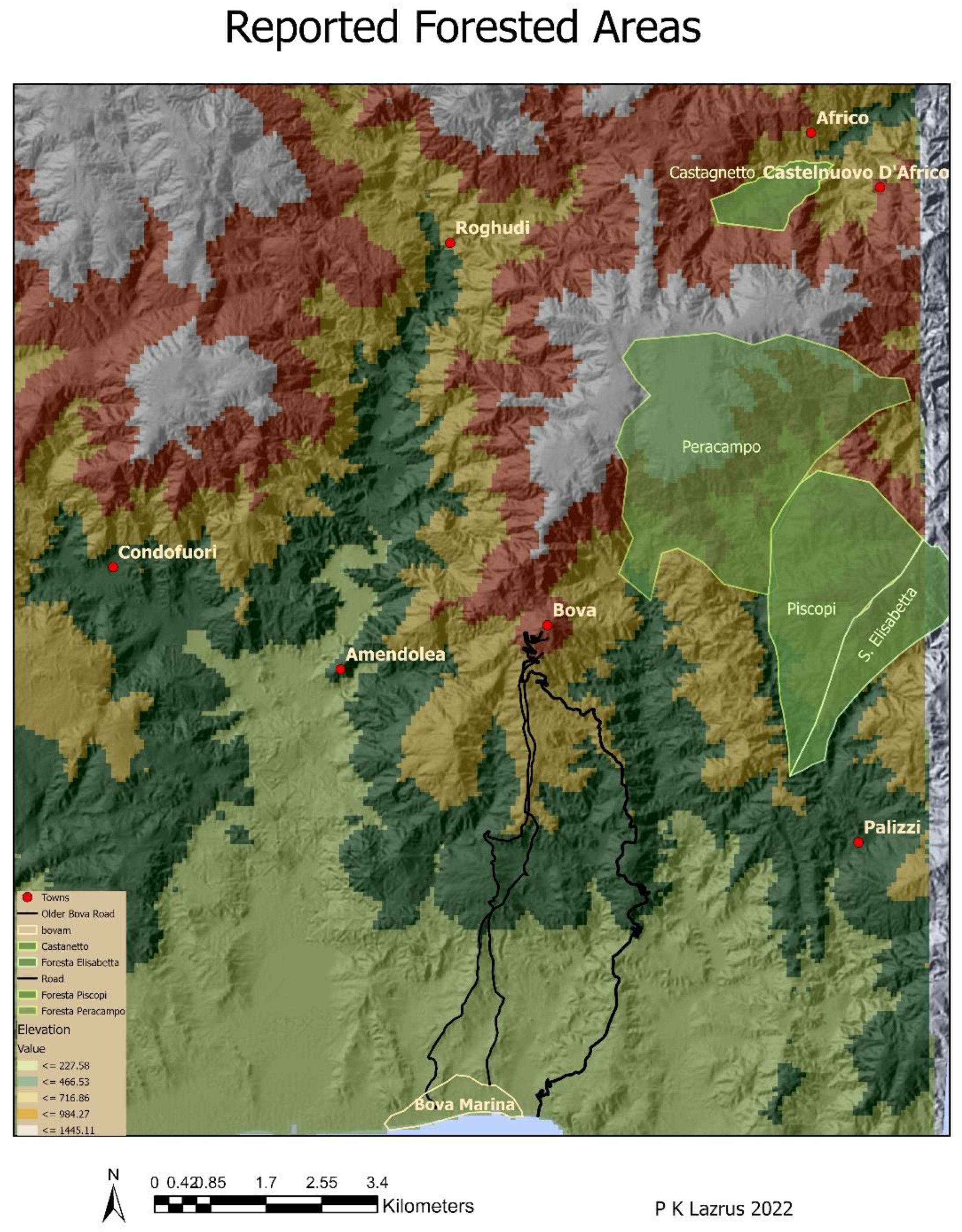
This work benefits from their study through the identification of locality names that reference particular plants, including Brigha and Vrica (tamarix), Grappida’ (wild pear), Ropie (oak), Mili, Agrillei and Amillei (ash), Castaneta (chestnut) and we can add to that list Cannata (cane) and Ambelli (vineyards) [4]. Today, one is hard-pressed to find ash and tamarix in most of the area. In general, the forests were almost exclusively lands that were owned by the Church or later by the municipality of Bova or its dependent, Africo. There are numerous legal documents in the form of claims and suits for non-payment or misuse of lands for grazing from the first quarter of the 19th century, although some of this is directed from the municipality of Bova to its subdivision Africo for non-payment of pasture, or other rights in the mountain forests [18,19] so this was clearly an integral part of the local economy. The legal discussions in the form of notarial papers detail the accusations of non-payment of rental fees or taxes, or suits to collect payments or trespassing in the forests, and they continue right up through the early 1900s [11,12,19,27,41,42,43]. These forested areas are located primarily to the north and northeast of town towards the current border with the municipality of Palizzi and include a variety of trees (Figure 16). Oaks and chestnuts were also listed in plots belonging to individual landholders who were taxed for the arboreal products or use of the land itself (Figure 15, Figure 16, Figure 17 and Figure 18). The trees listed in this manner in the two cadastres from the 1800s examined here are chestnuts, oaks, mulberries, figs, or fruit and nut trees.
The municipality is growing their trees at roughly 450 masl on undulating terrain with slopes up to 45 degrees in places, while Signore Nesci has his plot in the San Pasquale Valley, on terrain that rises to 100 m on slopes of no more than 16 degrees. Most of the forested areas are located to the east/southeast of Bova on slopes predominantly between 9 and 16 degrees at elevations between 500 and 800 masl, and the same is generally true for those forested areas to the north beyond the Bova plateau, although there, elevations rise to 1400+ masl.
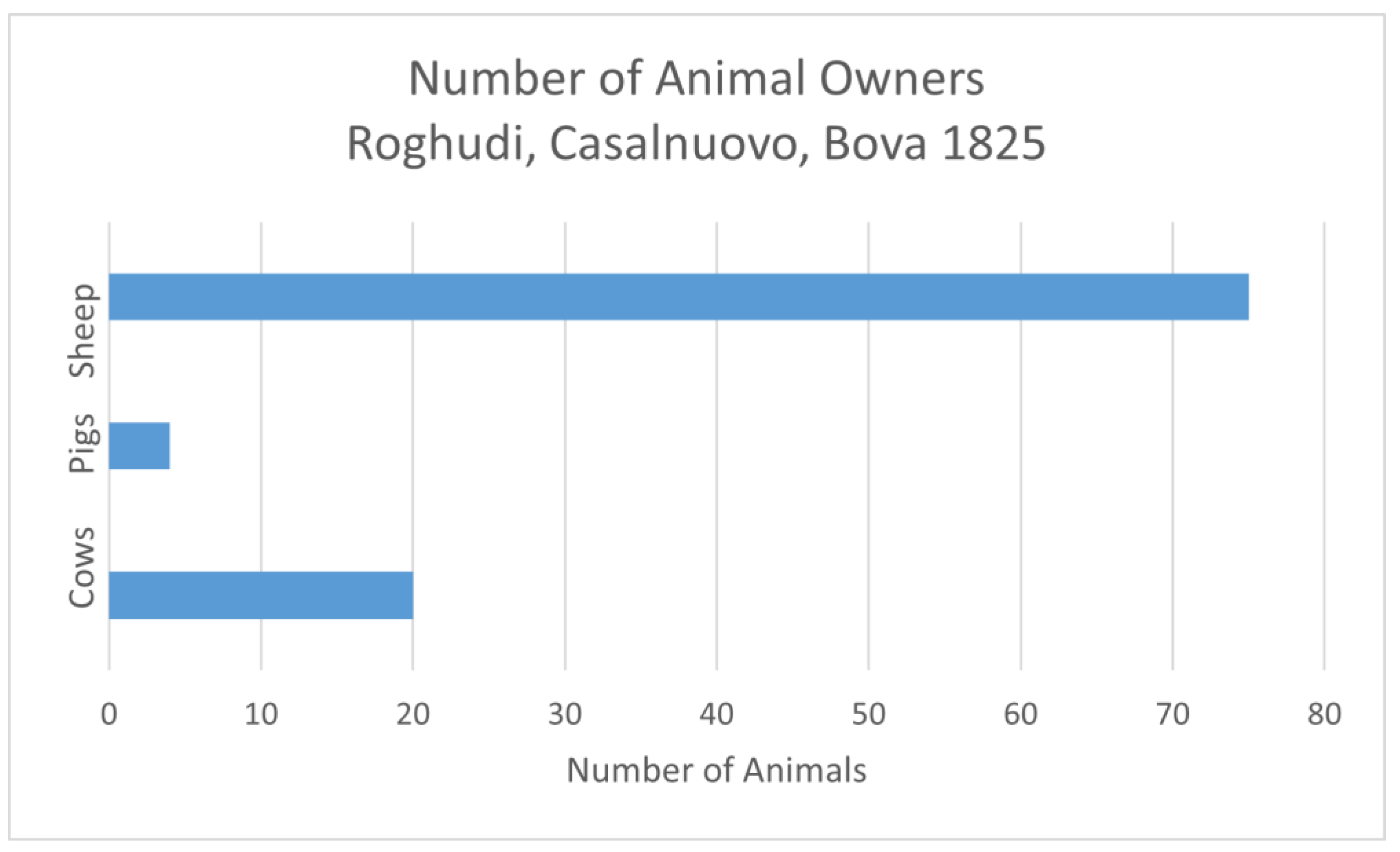
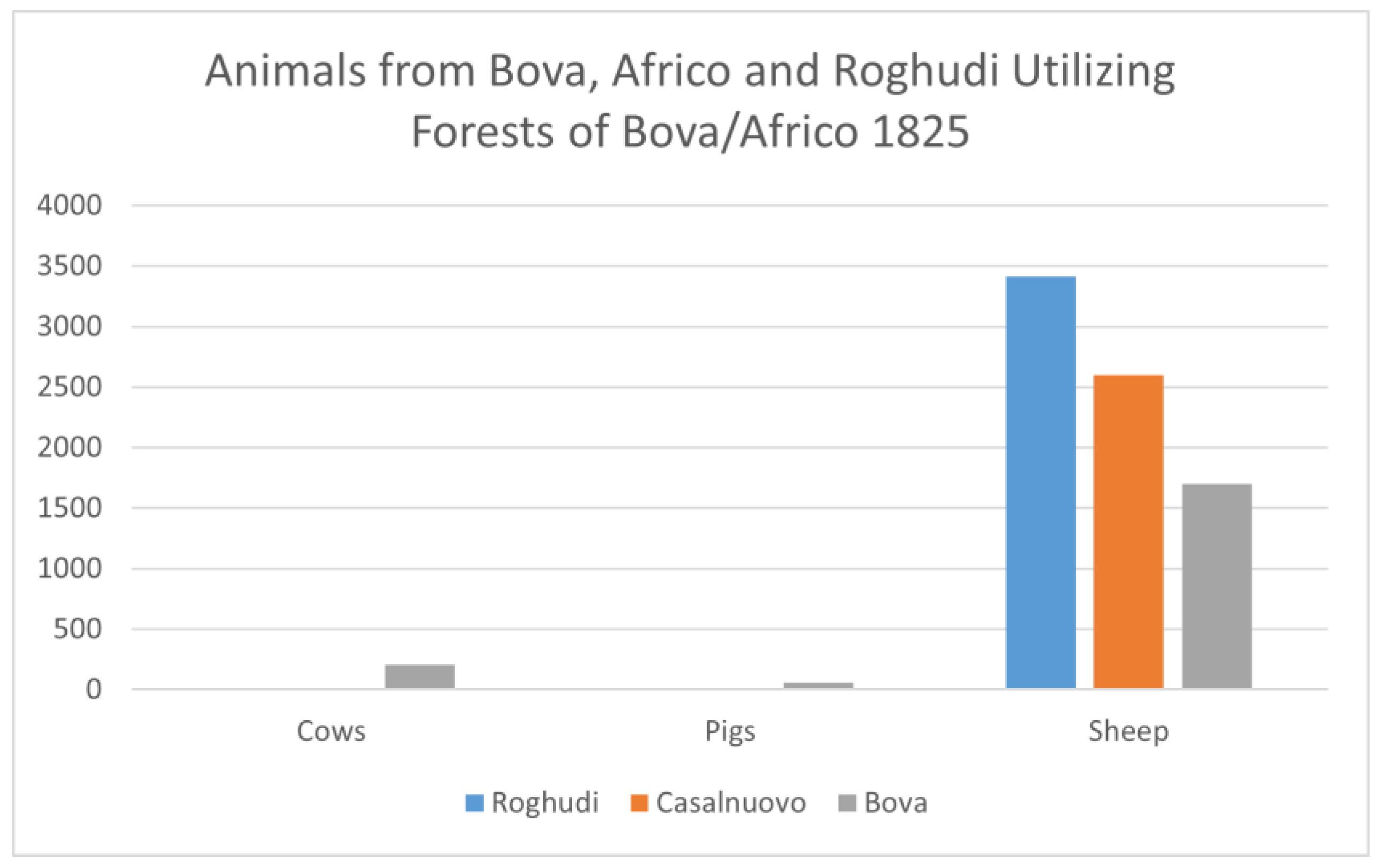
Moving from place to place along the coast or from the coast inland was costly and time-consuming, as can be noted in the remittances paid by the Ministero delle Finanze’s technical offices even as late as May and October of 1913. There were also comments by travelers from the 1500s through the early 1900s [8,9,14] (p. 31, 42, 43) elaborating on their difficulties. It is apparent as well from the records that those inland locations are frequently utilized. Lack of fresh water, the potential for flooding from the fiumara, and the fear of malaria may also have made the lowlands less appealing. One of the sticking points in the legal papers documenting the contentious split of the municipality of Bova into Bova and Bova Marina in 1908 was the claim by those who lobbied for Bova Marina that the division line gave all the control and access to fresh water to Bova (a rather specious claim since they all knew the sources were in the uplands) [42,43]. Pastureland was taxed, as noted earlier, but in neither the Catasto Murattiano nor the Stato di Sezione that followed in 1822 were animals listed for tax purposes [23,27]. They do appear in separate records from 1826/7 and 1832, among others [18,19]. Three main categories are listed in the extract of taxes for those pasturing animals in the mountains in 1825, cows, sheep/goats, and pigs [19]. In that listing, 52 owners kept a total of 267 oxen (at eight grane each), 5710 sheep and goats (one grana apiece), and 163 pigs (at 2.5 grane each) in the mountain pastures (Figure 19 and Figure 20).
Not everyone owned animals in each category, and the majority of ox holders held 2–4 animals; sheep and goat owners ranged from individuals who owned as few as 30 to as many as 340, and pig owners owned 10 or fewer animals [19]. It also is clear from the documents that oak, chestnut, and mixed beech forests were often used for pasture. We have evidence of competition for the use of these resources in the writings of Taruffi et al., who, in 1908, mention that chestnuts usually covered the steep sides of slopes, but in the period they were writing trees of 100s of years old were being cut down to supply factories producing tannin [43] (pp. 565–566).
5. Conclusions
Social & Economic Implications of Local Taskscapes
The 19th-century landscape was far richer and more varied than one might imagine based solely on an examination of the remains from our field survey. The land was able to support vegetation that it apparently can no longer accommodate in many places today. The sheer biodiversity in the uplands has certainly seen the most dramatic change, and while many of the plants listed are now rare in this area, they do still exist in the higher elevations of the Aspromonte, especially to the NW of town, and they are also a feature of the mountains of the Sila in what was once Calabria Superior. The abundant forests with holm oak and beech that covered the slopes in the higher elevations between Bova and Africo and east and south of Bova are, for the most part, gone. Twenty years after feudalism was officially abolished in Calabria, the division of land ownership was distributed among a marginally greater number of people than was the case earlier, and yet the Church remained an important political player. Whether Bova was far enough out of the political sphere of Reggio and Naples that the Church gave up none, or few of its lands, or potentially, the clergy were wealthy enough to buy it back is unclear. The citizenry as a whole was still resisting imperial controls in a subtle but persistent fashion. This seems to have been a conscious choice.
As noted in the opening section, only one person with the means to purchase the lands put up at auction took advantage of that opportunity [3] (pp. 10, 31–35, 39, 109–110). Giovanni Battista Panaghia, a lawyer, purchased five small pieces of land for 475 ducats in the first round of auctions in 1779. There are no further records of purchases from the community. This perhaps reflects their negative assessment of the overall effort to invest in these lands versus potential return from the market, a reflection of the lack of cash to purchase land, or a sign that it was never really up for sale. Certainly, there are indications of economic stress evident in the types of artifacts recovered. The goal of private property ownership for a larger group of citizens remained elusive for many years to come, as evidenced in the ongoing research in the San Pasquale Valley and can perhaps be seen as well in our survey work in the upper Aspromonte near Gambarie [38,39,44].
Among non-ecclesiastical individuals in the community, a physical doctor and two lawyers appear to be the dominant landowners and political movers. These gentlemen have properties in a wide range of locations and are those most likely to own property in conjunction with one another or with farmers who are likely to be their tenants. Wealth and status appear to offer the opportunity not for larger extents of property but rather for more parcels dispersed in slightly varied ecological conditions.
The range of crops grown, the combinations that people planted, and the relatively small plot sizes indicate a cropping system that reduces risk. The practice of having multiple owners in any given territory and no guarantee that one’s plots be contiguous also contributes to further mitigation of potential risk. That said, cadastral records from 1932 appear to show a shift in this practice at that moment, with people consolidating holdings whenever possible to have them closer together. Perhaps increased mobility from cars that could handle the dirt tracks, in addition to access to the railroad in Bova Marina, contributed to this shift. Oaks, chestnuts, beeches, figs, and mulberries, now rare, were once more prevalent in all directions from town and at nearly all elevations. Judging from areas that are more heavily vegetated today, the steep hills that retain trees also retain soil and are quite verdant. On the other hand, bergamot production, now very lucrative, did not begin to expand in the lowlands until the later 1800 and early 1900s. There are areas near Bova Marina today that are replacing vineyards and olive groves with bergamot.
After examining a variety of records that extend beyond the Napoleonic era while pursuing on-the-ground research, it is apparent that we need to re-adjust our image of the Bovan landscape and thus reconsider how people were utilizing this territory in the Post-Medieval period. During the 20 years that the Bova Marina Archaeological Project has been active in this area, it has become clear that this is a resilient landscape. It is one of constant change, reflecting not only how people exploit the landscape but also how they conceive of it.
The overwhelming simplicity of goods (cookware and water jars) points to economic circumstances also noted in Sicily [30]. Most of the land use that I have been able to map indicates that the majority of people owned land in the 430–640 masl range, but it is clear from the records, even if we cannot always map it, that there are many who held land in the area 1 to 4 km (as the crow flies) from town to the north and in the lowlands to the south in the 1–350 masl range, that is 5 to 8 km (as above) from town.
One conclusion we can draw from archival and spatial data is that there is less economic disparity than might be expected because although some institutions are better off, most members of society are surviving very simply. Because nearly all citizens hold multiple plots in diverse parts of the municipal territory, they are all apparently acting to mitigate risks related to environmental/topographic factors over the convenience of place or transport of goods. They are also thus able to help one another when there are crops that do not succeed in one area or another by pooling, sharing, or otherwise communally assisting one another. This is still the case.
No one is investing in the agricultural enterprise writ large in this community at this time. This is also apparent from the preference for payments in kind rather than cash. This choice kept one below the tax threshold but also did not allow for investment and growth. Fear of recurrent disasters, and natural or political upheavals with their concomitant shifts in demands, left a rather tight margin of error and made people wary of the new. On some level, more investment might have mitigated some of these effects, but perhaps here, the level of investment needed was just that much beyond reach and so being on the edge and of a generally conservative nature, it was easier to stay marginal than to risk expansion.
The market for goods appears very local, and connections to regional or international markets are limited or non-existent during the period under examination. Certainly, in this period, the French blockade of trade with the English and the shipping requirements inhibiting trade, as discussed previously, would have been major considerations to land improvement strategies. The commodities of the greatest value for commerce, textiles, and oil, are perishable but not necessarily oil presses or jars. It is possible that some of the plain containers we identify as water jars were, in fact, used to transport oil, but since we mostly have rims and handles, it is not clear what was kept in them. The raw silk thread could have been transported in baskets or cloth bags and thus would leave little archaeological trace.
Even those who were better off as a class were not that much richer than their neighbors, and this appears to be supported by the relative lack of luxury goods within our Post-Medieval assemblage. Considering the sale of Church property and goods over a period of 15 years or so, there is a surprising paucity of prestige artifacts from this period. This provides some archaeological support for the records that all (or nearly) this land was sold off for the Cassa Sacra, and yet the Church remained the most powerful and wealthy entity in the community. The Church (and its personnel) may have owned the most property overall, and perhaps land that was easier to tend because, as mentioned above, they repurchased it., but those plots are not always closer to the active roads of the day (Bova Marina was not a destination at the time) nor to facilities such as mills or olive/wine presses.
In conversations with current residents regarding their choices in terms of agricultural production, it has become clear that there are echoes of earlier practices that continue into the contemporary period. Some vineyard owners and those with olives groves have been choosing not to harvest the crops or only to bottle enough for family use because the modern requirements for taxes and shipping leave them with little or no profit. As a result, rather than lose money or gain very little, they have chosen to leave the crops in the field or to harvest and process the fruit for family use. The economics do not add up, just as they did not 200 years ago. There is still much work to be done to tease out the more subtle differences among the inhabitants in the early 1800s, including trying to understand the subtle benefits of locations within the preferred zones and beyond the ease of getting to and from town where most people lived. Extracting these more subtle aspects of who owned what and where is the next challenge.
Supplementary Materials
The following supporting information can be downloaded at https://www.mdpi.com/article/10.3390/land11101832/s1. Table S1: Individual tax data; Table S2: Organizational tax data; Table S3: Agricultural artifacts.
Funding
This project was developed out of a paper given at the Political Logic of Mediterranean Landscapes Conference, Rome, Italy, in 2018. That paper, Spatial distribution of crops and the social dynamics of an early 19th community. The conference was funded with an internal grant to its organizers through the University of Notre Dame in Indiana, USA.
Data Availability Statement
Archaeological data for this project that was collected through fieldwork is not my property to publish at this time. All archival data referenced here came either from Archivo di Stato in Reggio Calabria. http://archiviodistatoreggiocalabria.beniculturali.it/; Maps held by the Instituto Geographico Militare Italiano in Florence Https://IGMI.org, or at the Archivo di Stato in Naples https://www.archiviodistatonapoli.it and can be consulted by visit/appointment. Data that was extracted from the Catasto Murratiano is available in Supplementary Materials Tables S1 and S2.
Acknowledgments
I would like to thank John Robb, Lin Foxhall, David Yoon, Meredith Chesson, and Isaac Ullah for the opportunity to work at Bova and for their support of my research there. Their financial travel support has been invaluable, as well as our many discussions regarding our collective work in the area. Thanks are also due to David for sharing some of the applicable survey data, and to Hamish Forbes for many useful conversations about rural life both in the field and elsewhere. Special thanks to Isaac Ullah, Meredith Chesson, and Kostalena Michiklaki for many fruitful conversations and technical insights. In addition, thanks must be tendered to my colleagues at the Soprintendeza Archaeologica di Reggio, the Archivio di Stato di Reggio, the Archivio di Stato di Napoli, the Biblioteca Nazionale di Napoli, and the Biblioteca Nazionale Braidense di Milano for assistance finding and deciphering archival materials. Without their assistance, none of this would be possible.
Conflicts of Interest
The author declares no conflict of interest.
References
- Zarinebaf, F.; Bennet, J.; Davis, J.L.; Gorogianni, E.; Harlan, D.K.; Kiel, M.; MacKay, P.A.; Wallrodt, J.; Wolpert, A.D. A Historical and Economic Geography of Ottoman Greece. Hesperia Suppl. 2005, 34, i-328. [Google Scholar]
- Barker, G. A Mediterranean Valley: Landscape Archaeology and Annales History in the Biferno Valley; Leicester University Press: London, UK; New York, NY, USA, 1995; ISBN 0-7185-1906-X. [Google Scholar]
- Placanica, A. Alle Origini Dell’egemonia Borghese in Calabria: La Privatizzazione Delle Terre Ecclesiastiche (1784–1815); Societa Editrice Meridionale: Salerno, Italy; Catanzaro Societa Editrice Meridionale: Calabria, Italy, 1979; ISBN L20000. [Google Scholar]
- Spampinato, G.; Crisarà, R.; Cameriere, P.; Cano-Ortiz, A.; Musarella, C.M. Analysis of the Forest Landscape and Its Transformations through Phytotoponyms: A Case Study in Calabria (Southern Italy). Land 2022, 11, 518. [Google Scholar] [CrossRef]
- Gaimster, D. An Embarrassment of Riches? Post-Medieval Archaeology in Northern and Central Europe. In International Handbook of Historical Archaeology; Majewski, T., Gaimster, D., Eds.; Springer: New York, NY, USA, 2009; pp. 525–547. [Google Scholar]
- Lazrus, P.K. Reacting to the Powers That Be: Investigations of a Calabrian, Post-Medieval Community. Int. J. Hist. Archaeol. 2014, 18, 65–99. [Google Scholar] [CrossRef] [Green Version]
- Davis, J.A. Naples and Napoleon: Southern Italy and the European Revolutions (1780–1860); Oxford University Press: Oxford, NY, USA, 2006. [Google Scholar]
- Marafioti, G. Opera Del R P Fra Girolamo Marafioti Di Polistina Delle Croniche, Et Antichita Di Calabria, Secondo le Citta, Habitationi, Luoghi, Monti, Fiumi, e Fonti di Quella, co L’historie di Tutti gli Huomini Illustri Calabresi, Quali in Diuerse Scienze, & Arti Fiorirno, col Catologo de gli Beati, e Santi; Nella Stamperia dello Stigliola a Porta Regale: Napoli, Italy, 1595; Volume 557, p. 1. [Google Scholar]
- Saint-Non, J.C.R. Voyage Pittoresque, ou, Description des Royaumes de Naples et de Sicile. // A Paris De l’Imprimerie de Clousier, 1781–1786; De l’Imprimerie de Clousier: Paris, France, 1781. [Google Scholar]
- Galanti, G.M. Calabria 1792: Diarii, Relazioni e Lettere di un Visitatore Generale; Elea Press: Salerno, Italy, 1806; p. 588. [Google Scholar]
- Comune di Bova. Usupazione del Fondo Montagna; Archivo di Stato di Reggio Calabria: Busta, Italy, 1819. [Google Scholar]
- Comune di Bova. Affitto Delle Foreste Comunali. Archivo di Reggio Calabria; Archivo di Stato di Reggio Calabria: Busta, Italy, 1821. [Google Scholar]
- Caldora, U. Calabria Napoleonica (1806–1815); Napoli. F. Fiorentino: Napoli, Italy, 1960; p. 482. [Google Scholar]
- Lear, E. Diario di un Viaggio a Piedi. Reggio Calabria e la sua Provincia (24 Luglio–5 Settembre 1847); Laruffa Editore: Reggio Calabria, Italy, 2003. [Google Scholar]
- Pasquale, G.A. Relazione Sullo Stato Fisico-Economico Agrario Della Prima Calabria Ulteriore; Tipolgrafia R. Albergo d’Poveri: Napoli, Italy, 1863. [Google Scholar]
- Galasso, G. Economia e Societa Nella Calabria del Cinquecento; L’Arte tip: Napoli, Italy, 1967; p. 480. [Google Scholar]
- Gambi, L. Calabria; Unione Tipografico-Editrice Torinese: Torino, Italy, 1965; p. 564. [Google Scholar]
- Tassa tra gli usari del fondo Montagna; Archivio di Stato Reggio Calabria: Busta, Italy, 1832.
- Fitto di Beni Communale; Archivio di Stato Reggio Calabria: Busta, Italy, 1842.
- Foxhall, L. Bova Marina Archaeological Project, Preliminary Report 2006 Season; University of Leicester: Leicester, UK, 2006; Available online: http://www.arch.cam.ac.uk/~jer39/BMAP/reports/BMAP%202006%20report.pdf (accessed on 30 August 2022).
- Bova Marina Archaeological Project. 2011. Available online: http://www.arch.cam.ac.uk/~jer39/BMAP/Reports.html (accessed on 8 October 2012).
- Catasto Murattiano; Archivo di Stato di Reggio Calabria: Busta, Italy, 1807.
- Snead, J.E.; Erickson, C.L.; Darling, J.A. Landscapes of Movement: Trails, Paths, and Roads in Anthropological Perspective; University of Pennsylvania Museum of Archaeology and Anthropology: Philadelphia, PA, USA, 2009. [Google Scholar]
- Di Scala, S.M. Italy: From Revolution to Republic: 1700 to the Present; Westview Press: Boulder, CO, USA, 1995. [Google Scholar]
- Reggio Camera della Sommaria, Catasti Onciari, Prima Calabria Ulteriore, Bova; Napoli Archivo di Stato-Onciario: Busta, Italy, 1742.
- Stato di Sezione. Contribuzione Fondari. Processo Verbale Della Divisione del Territorio di Bova in Otto Sezione; Archivo di Stato di Reggio Calabria: Busta, Italy, 1822. [Google Scholar]
- Maps, Foglio 148 Spartivento, Foglio 138 Staiti; Instituto Geographico Militare: Florence, Italy, 1870.
- Pluciennik, M.; Mientjes, A.; Giannitrapani, E. Archaeologies of Aspiration: Historical Archaeology in Rural Central Sicily. Int. J. Hist. Archaeol. 2004, 8, 27–65. [Google Scholar] [CrossRef]
- Ciaccio, C. La Casa Rurale nella Calabria; Manzi, E., Ruggiero, V., Eds.; Leo S. Olschki: Firenze, Italy, 1987; pp. 427–446. [Google Scholar]
- Caridi, G. L’invenzione Della Marina. Il Processo di Urbanizzazione a valle di Bova (1742–1908); Citta del Sole Edizioni s.a.s.: Reggio Calabria, Italy, 2013. [Google Scholar]
- Itineraria Tavoloa XXIII F 26, Inventario 198; Instituto Geografico Militare: Firenze, Italy, 1871.
- Gibson, E. The Archaeology of Movement in a Mediterranean Landscape. J. Mediterr. Archaeol. 2007, 20, 61–87. [Google Scholar] [CrossRef]
- Caridi, G. La Calabria nella storia del Mezzogiorno Secoli XI-XIX Testi e Documenti; Citta del Sole Edizioni s.a.s.: Reggio Calabria, Italy, 2013. [Google Scholar]
- Misafari, E. Storia Sociale della Calabria; Jaca Book: Milano, Italy, 1973. [Google Scholar]
- Ferrante, N. Il Monte-dei-Pegni-Pawning Activities in the Archdiocese of Bova. Historica 1993, 46, 80–84. [Google Scholar]
- Fusco, I. The Spread of Technology through Commercial Networks in the Nineteenth Century: Foreign Merchant-entrepreneurs and Calabrian Sericulture amid Changes and Conflicts. Hist. Rev./La Rev. Hist. 2010, 7, 253–275. [Google Scholar] [CrossRef] [Green Version]
- Swindburne, H. Travels in the Two Sicilies; P. Elmsly: Dublin, Ireland, 1783. [Google Scholar]
- Chesson, M.S.; Ullah, I.I.T.; Iiriti, G.; Forbes, H.; Lazrus, P.K.; Ames, N.; Garcia, Y.; Benchekroun, S.; Robb, J.; Wolff, N.P.S.; et al. Engaged Archaeology in San Pasquale Valley; Archaeology as Intellectual Service: Calabria, Italy, 2019; Volume 15, pp. 422–443. [Google Scholar] [CrossRef]
- Chesson, M.S.; Ullah, I.I.T.; Ames, N.; Benchekroun, S.; Forbes, H.; Garcia, Y.; Iiriti, G.; Lazrus, P.K.; Robb, J.; Squillaci, M.O.; et al. Laborscapes and Archaeologies of Sustainability: Early Globalization and Commercial Farming in the San Pasquale Valley, Calabria, Italy from AD 1800–2018. J. Mediterr. Archaeol. 2019, 32, 32–62. [Google Scholar] [CrossRef]
- Caldora, U. Storia e Cultura del Mezzogiorno: Studi in Memoria di Umberto Caldora; Cosenza Lerici: Lerici, Italy, 1978; p. 655. [Google Scholar]
- Prodotti Della Montagna Indivisa Bova-Africo-Roghudi; Archivo di Stato di Reggio Calabria: Busta, Italy, 1826.
- Costificazione di Bova Superiore e Bova Marina in Comune Autonomi; Prefetto R.C.; 273 Inv 24/1 # 26 Municip di Bova # 1993; Archivo di Stato di Reggio Calabria: Busta, Italy, 1907.
- Taruffi, D.; Nobile, L.D.; Lodi, C. La Questione Agraria e L’Emigrazione in Calabria; Presso G. Barbera: Firenze, Italy, 1908. [Google Scholar]
- Robb, J.; Chesson, M.S.; Forbes, H.; Foxhall, L.; Foxhall-Forbes, H.; Lazrus, P.K.; Michelaki, K.; Chiodo, A.P.; Yoon, D. The Twentieth Century Invention of Ancient Mountains: The Archaeology of Highland Aspromonte. Int. J. Hist. Archaeol. 2020, 25, 14–44. Available online: http://link.springer.com/10.1007/s10761-020-00543-x (accessed on 13 May 2020). [CrossRef]
Figure 1.
Town of Bova and communities under its authority in the Napoleonic Period.

Figure 2.
Images taken by the author of the contemporary Bovan landscape.

Figure 3.
Mapped localities.

Figure 4.
House Type Distribution extracted from 1897 Cadastre.

Figure 5.
Examples of rural structures. Photos taken by author.

Figure 6.
Commercial trails digitized from the original map of 1871 [31].
Figure 6.
Commercial trails digitized from the original map of 1871 [31].

Figure 7.
A selection of Post-Medieval artifacts from the BMAP surveys.

Figure 8.
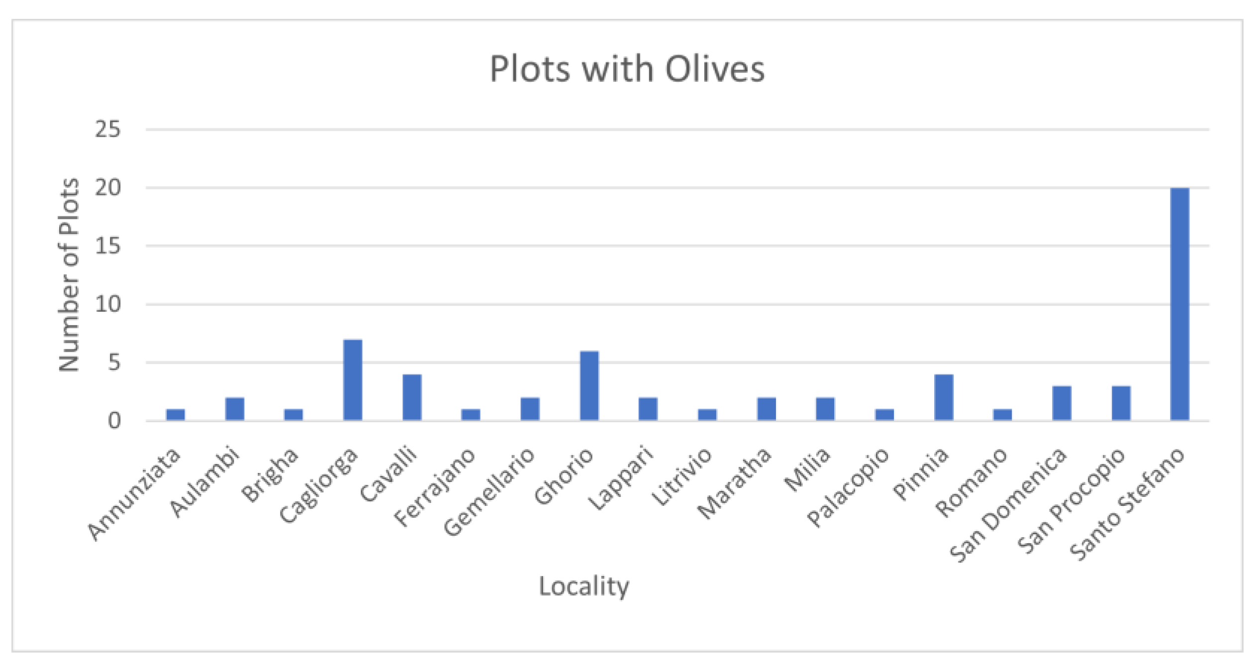
Olive distribution in mapped localities, extracted from 1807 Cadaster.

Figure 9.
Location of artifacts related to processing olives, extracted from 1807 Cadastre.

Figure 10.
Hectares taxed by percentage of population group, extracted from 1807 Cadastre.

Figure 11.
Land owned by organizations extracted from the 1807 cadaster.

Figure 12.
Amount of taxed property owned by people of diverse professions, extracted from 1807 Cadaster.
Figure 12.
Amount of taxed property owned by people of diverse professions, extracted from 1807 Cadaster.

Figure 13.
Slope and mapped localities.

Figure 14.
Evidence of threshing floors from survey.

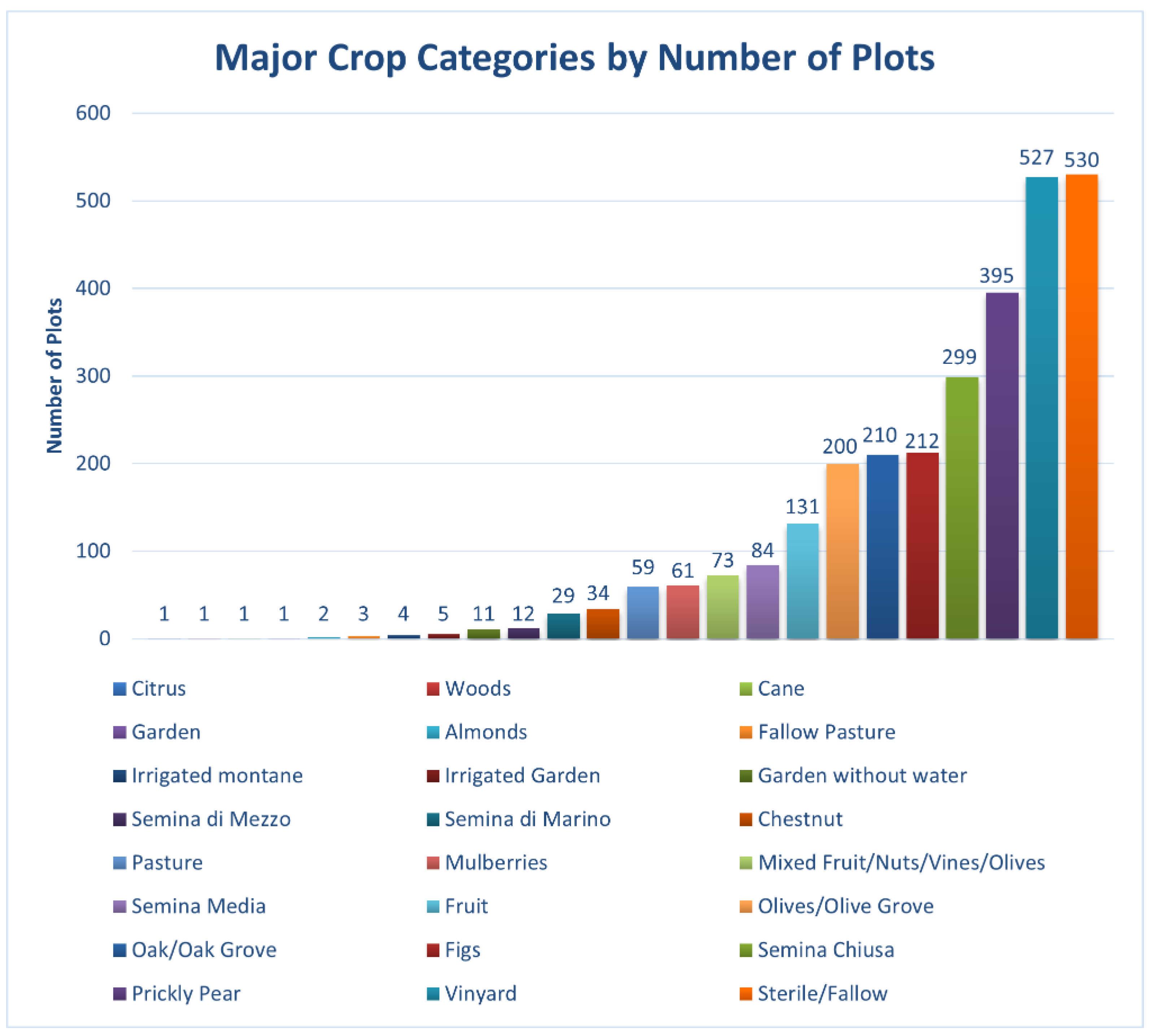
Figure 15.
Major plant categories and number of cadastral entries, extracted from 1807 Cadaster.

Figure 16.
Forested areas.

Figure 17.
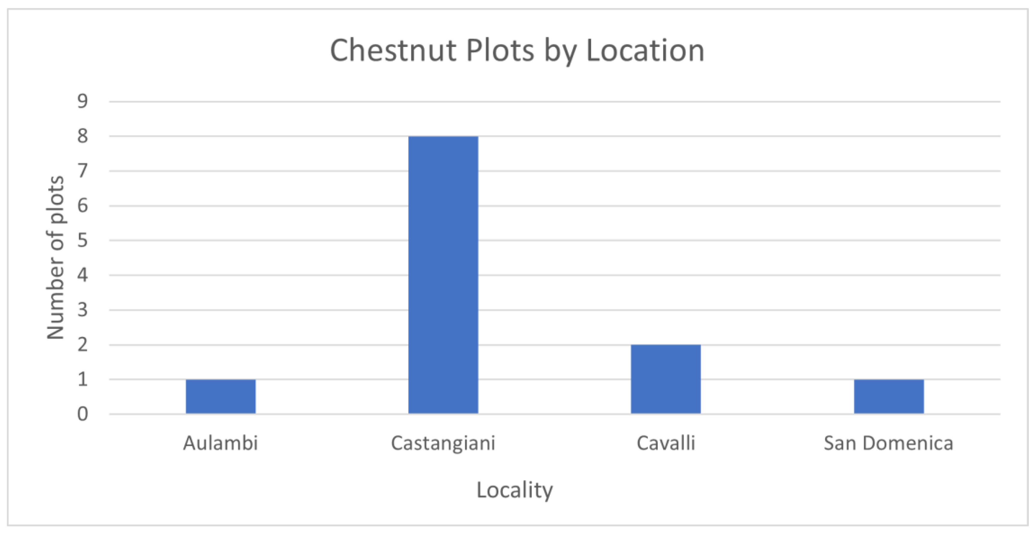
Distribution of chestnuts plot across mapped localities, extracted from 1807 Cadastre.

Figure 18.
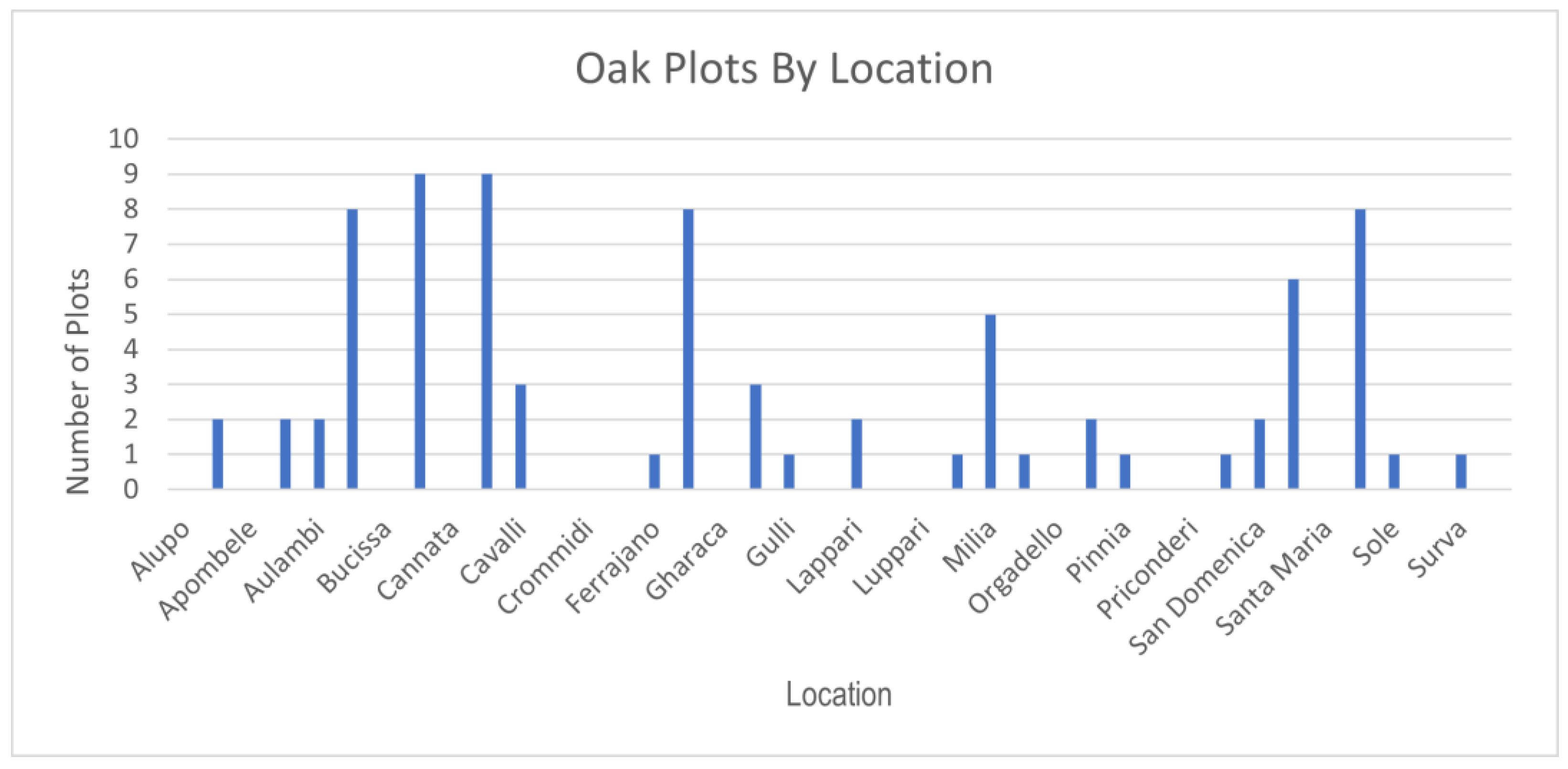
Distribution of oak plots across mapped localities, extracted from 1807 Cadastre.

Figure 19.
Animal ownership.

Figure 20.
Animals in forested areas.


Table 1.
Community of residence for citizens listed as paying taxes in Bova in the Cadastre of 1807.
Table 1.
Community of residence for citizens listed as paying taxes in Bova in the Cadastre of 1807.
| Town | # of Citizens |
|---|---|
| Africo | 3 |
| Amendolea | 3 |
| Bagaladi | 4 |
| Bova | 459 |
| Casalnuovo di Africo | 1 |
| Condofuri | 1 |
| Grotteria | 1 |
| Napoli | 1 |
| Palizzi | 1 |
| Reggio | 6 |
| Reggio in Bova | 2 |
| Roghudi | 2 |
| Unknown | 391 |
Table 2.
General land ownership in hectares, extracted from 1807 Cadastre.
| Owner | Total Hectares | Average Plot Size |
|---|---|---|
| Church (as organization) | 1243.24 | 3.42 |
| Municipality | 363.902 | 1.23 |
| Church (Individuals) | 514.53 | 2.81 |
| All Non Ecclesiastical Citizens | 1101.79 | 0.40 |
| All Non-Professional citizens | 637.33 | 0.36 |
| Three Largest Landholders | 135.59 | 0.56 |
Table 3.
Crop Distribution—major players per the 1807 Cadastre.
| Owner | Figs | Fruits | Grain | Barley | Mulberries | Vines | Olives | Oaks | Pricky Pear | Grazing | Sterile | Chestnuts | Irrigated Land | Citrus |
|---|---|---|---|---|---|---|---|---|---|---|---|---|---|---|
| Mesiano Giovanni Domenico | 1.63 | 0.13 | 19.71 | 0.73 | 0.94 | 0.72 | 1.00 | 1.81 | 0.01 | 0.30 | 14.25 | 0 | ||
| Nesci Domenico | 1.30 | 2.32 | 12.58 | 0.93 | 3.93 | 0.29 | 0.84 | 4.38 | 0.78 | 6.66 | 13.27 | 0 | ||
| Panagia Giovanni Battista | 4.48 | 0.78 | 10.58 | 1.19 | 0.69 | 1.83 | 1.38 | 6.02 | 2.39 | 1.50 | 11.75 | 0.52 | 1.11 | 0 |
| Church (as Organization) | 0.91 | 0.45 | 152.93 | 139.89 | 0.48 | 0.73 | 3.42 | 3.98 | 158.19 | 779.73 | 3.89 | 0.57 | 0.24 |
Table 4.
List of professions extracted from cadastre of 1807.
| Profession | Profession Cont |
|---|---|
| Abbate | Magnifico |
| Archiprete | Magnifico Civile |
| Archivescovo di Reggio | Massaro |
| Bracciante | Molinaro |
| Canonico | Mulettiere/Molettiero |
| Canonico Tesoriale | Notaio |
| Cieco | Ortolano |
| Diacono | Parroco |
| Falegname | Pecorajo |
| Forese | Sacerdote |
| Macellaro | Signora |
| Maestro | Signore |
| Maestro Barbiere | Signore Alfiere Invalido |
| Maestro Bardajo | Signore Canonico |
| Maestro Calzoliao | Signore Dottore di Legge |
| Master Fabricatore | Signore Dottore Fiscio |
| Maestro Galegname | Signore Giudice |
| Maestro Ferrano | Signore Giudice a Contratto |
| Maestro Muratore | Signore Notaio |
| Maestro Sartore | Signore Speciale di Medicina |
| Maestro Tegolaro | Signore Speciale Manuale |
| Maestro Tessitore | Signore Tenente di Marina |
| Maestro Vasaro | Unknown |
Publisher’s Note: MDPI stays neutral with regard to jurisdictional claims in published maps and institutional affiliations. |
© 2022 by the author. Licensee MDPI, Basel, Switzerland. This article is an open access article distributed under the terms and conditions of the Creative Commons Attribution (CC BY) license (https://creativecommons.org/licenses/by/4.0/).
Share and Cite
MDPI and ACS Style
Lazrus, P.K. Land Use and Social Dynamics in Early 19th Century Bova, Calabria. Land 2022, 11, 1832. https://doi.org/10.3390/land11101832
AMA Style
Lazrus PK. Land Use and Social Dynamics in Early 19th Century Bova, Calabria. Land. 2022; 11(10):1832. https://doi.org/10.3390/land11101832
Chicago/Turabian StyleLazrus, Paula Kay. 2022. "Land Use and Social Dynamics in Early 19th Century Bova, Calabria" Land 11, no. 10: 1832. https://doi.org/10.3390/land11101832
Note that from the first issue of 2016, this journal uses article numbers instead of page numbers. See further details here.