Article

Knowledge of the Sky among Indigenous Peoples of the South American Lowlands—First Archaeoastronomical Analyses of Orientations at Mounds in Uruguay

by
Camila Gianotti
1,
A. César González-García
2,*,
Nicolás Gazzán
3,
Cristina Cancela-Cereijo
4 and
Moira Sotelo
4
1
Laboratorio de Arqueología del Paisaje y Patrimonio, Departamento de Sistemas Agrarios y Paisajes Culturales, Centro Universitario Regional del Este, Universidad de la República, Rocha 27000, Uruguay
2
Instituto de Ciencias del Patrimonio, INCIPIT, Consejo Superior de Investigaciones Científicas (CSIC), 15707 Santiago de Compostela, Spain
3
Laboratorio de Arqueología del Paisaje y Patrimonio del Uruguay, Centro Universitario Regional del Este, Universidad de la República, Rocha 27000, Uruguay
4
Laboratorio de Arqueología del Paisaje y Patrimonio del Uruguay, Facultad de Humanidades y Ciencias de la Educación, Universidad de la República, Montevideo 11200, Uruguay
*
Author to whom correspondence should be addressed.
Land 2023, 12(4), 805; https://doi.org/10.3390/land12040805
Submission received: 21 February 2023 / Revised: 28 March 2023 / Accepted: 31 March 2023 / Published: 2 April 2023

Abstract

:
We analyzed, from a cultural astronomy perspective, the relationship between the orientations of five mound sites and different astronomical events in the lowland region of Uruguay. We found significant relationships between the orientations of the mounds and the Southern Cross/Milky Way and the full Moon during the winter solstice ca. 3000 years BP. These relationships, meanings and senses to different native peoples of South America were explored from the literature of travelers’ and naturalists’ chronicles, alongside the ethnohistorical, ethnographic and archaeological literature. In particular, we highlighted the link among those peoples of the area of the Southern Cross/ Milky Way with a mythical Ñandú (Rhea americana). Such an interpretation has allowed us to raise the possibility that we are being faced with the integration of knowledge of the sky in the form of the social construction of inhabited space and the configuration of the landscape.

1. Introduction

1.1. Cosmovisions, Sky knowledge and Landscape Archaeology

The sky has played and continues to play an important role in the construction of reality in most societies, particularly in oral societies and specifically in South America [1,2,3,4]. Several societies organize their cosmos in planes inhabited by diverse entities, the sky being one of them [5]. The practical character of this knowledge about the sky is frequently materialized in daily life. On the one hand, we find that practices, architectural forms as well as the organization of inhabited spaces recurrently include references to the sky [6,7]. On the other hand, the time and temporalities of daily behaviors and rituals are often defined or conditioned by the position and movement of the heavenly bodies [8].
In the Americas, studies on archaeoastronomy and cultural astronomy abound regarding the peoples of Mesoamerica, the Caribbean, the Andean area and the southwest of the United States [9,10,11,12,13,14,15], and for the last 20 years, there has been a growing body of work focusing on the South American lowlands [2,3,5,16,17]. Furthermore, South American groups have deployed complex interethnic networks which connect the knowledge, people, goods and ideas not only within the Lowlands but also within the Highlands [3].
The knowledge and role played by some asterisms, planets, stars and constellations such as the Milky Way, the Pleiades or the Southern Cross, among others, appears in several chronicles of travelers, Jesuit priests and naturalists between the 17th and 19th centuries for groups from Patagonia, the Pampas, the Chaco, the Atlantic coastal region, Amazonia and the Caribbean [18,19,20,21,22,23,24,25,26]. They describe the importance for those people of knowing and classifying the passing of time during the day and night, during an annual cycle as well as for the celebration of rituals and ceremonies [18,19,20,27,28,29].
Ethnoastronomical studies were developed in the Chaco area with groups of the Guaycurúes linguistic stock, such as the Moqoit (hunter-gatherers until the arrival of the Europeans) and Tobas [2], or in the Amazon area among Tupi-guaraní or Tukano groups, among others [29]. All of them have highlighted the role of the sky in the indigenous cosmovision, how it defines the representation and characterizations of time and space, and how it conditions a large part of their religious practices and beliefs [2,30].
Among the Moqoit, the Milky Way, the Sun and Moon, the Magellan clouds and the stars are used for orientation and temporal positioning within an annual cycle [5]. Several studies recognize the importance of the sky in human spatiality and in the configuration of territories [31,32,33,34,35]. However, there are few archaeoastronomical studies that analyze how this knowledge of the sky has manifested itself in the spatial organization of settlements and territories in the South American lowlands in the past.
Given the growing loss of this knowledge, archaeoastronomy and cultural astronomy constitute first-order disciplines to address the material evidence of past and present societies. Calendars, cycles of celestial objects and architectural orientations and their relationship to the sky have been extensively studied in different South American regions, but with special attention to the Andean societies [9,36,37,38,39,40].
The construction of the city of Caral (Supe Valley) in Peru demonstrates a well-developed spatial and astronomical awareness and how this materialized in the organization of the city space and architecture [41]. Other archaeoastronomical approaches have allowed us to grasp how South American peoples incorporated and even modified their environment, incorporating the heavens. One example that has epitomized such a landscape construction is the case of Chankillo in Peru [42], where the people that inhabited this area on the central coast of Peru modified the landscape by building 13 towers that defined a skyline, which might have helped them to identify particularly important moments in their daily life. At the Villa de Leiva site (Colombia), the orientation of 25 columns was related to the midpoint between major solstices, known as the spatial equinox [40]. Additionally, in Catamarca (Argentina), in the late settlement of Rincón Chico in the Yocavil valley, several constructions located in this ravine were aligned, possibly to mark and observe the sunset during the December solstice [43] (p. 68). In this sense, one of the few works we can mention of an archaeoastronomical study on the South American Lowlands is that on the orientation of the Moxos Lagoons in Bolivia, where their orientation was linked with the appearance and setting of the Southern Cross [44].
It is thus clear that the location and orientation of built ensembles need to be understood in the context of their landscape. In fact, the “landscape”, as a social construction, has been shaped by social action [45,46], which has two main aspects. On the one hand, there is a tangible dimension where social action modifies through time, consciously or not, the elements in that space. The second pertains to the conceptual sphere and how a particular space is seen and understood according to a particular mindset [47]. Landscape, therefore, is not a passive support for human action; it is a construct, a territorialized assemblage of knowledge, places and complex relations [48,49]. In this scheme, archaeoastronomy appears a key element in understanding such social constructions of space and of ancient landscapes, which is the field of work of landscape archaeology [50]. Thus, combining the study of archaeological landscapes with archaeoastronomy and cultural astronomy enables approaches to human spatiality, from its materiality and layers of meaning, in terms of particular landscape configurations and the interrelationships that constitute it. In particular, there is a need to integrate these approaches and develop landscape archaeology that can objectify the knowledge of the sky and how these are key to holistically analyzing specific architectures and spatial arrangements and relating them to conceptions/representations of time.
Different processes of the permanent transformation of the environment and social construction of landscapes, with different scales and intensities, have characterized the dynamics of human occupation in the South American lowlands during the second half of the Holocene [51,52,53]. During this period, the construction of different types of earthen architectures (monumental mounds, earthworks, geometric ditches enclosures, among others) reflected a series of changes that showed the consolidation of community modes of organization, social complexity, a demographic increase and the demarcation of distinct ethnic territories, in ecologically distant and culturally diverse regions [54,55,56,57,58,59,60]. A good part of these architectures manifests complex spatial organizations, recurrent orientations and patterns in their locations (e.g., [61,62,63]).
The construction of mounds in the lowlands of Uruguay and southern Brazil (locally known as cerritos de indios or aterros) has been understood as a technology of artificialization of the inhabited space and has allowed the economic, social and symbolic management of a particular type of wetland environment: the lowlands [64]. Cerritos manifested recurrent distribution and location patterns that have been associated with areas of resource concentration [65,66], with visual control over relevant landscape features, resources, transit zones and neighboring villages [67] with aggregation spaces [68,69]. However, the recurrent orientations, both of mounds and mound assemblages, have not been the subject of archaeoastronomical study so far.
In this paper, we analyze the relationship between orientations and locations of some sets of earthen mounds and particular astronomical manifestations in order to discuss to what extent the knowledge of the sky can be considered part of this technology. These results prompt us to discuss how certain constellations or asterisms could have played a key role in the organization of inhabited space and territory among the indigenous peoples who built the mounds. Furthermore, this knowledge allows us to approach particular conceptions of time and natural cycles, which are especially useful for inhabiting these humid ecosystems. Finally, the results gain further relevance when contrasted with ethnographic, ethnohistoric and archaeological information from different groups in the region.

1.2. The Mounds of the Uruguayan Lowlands
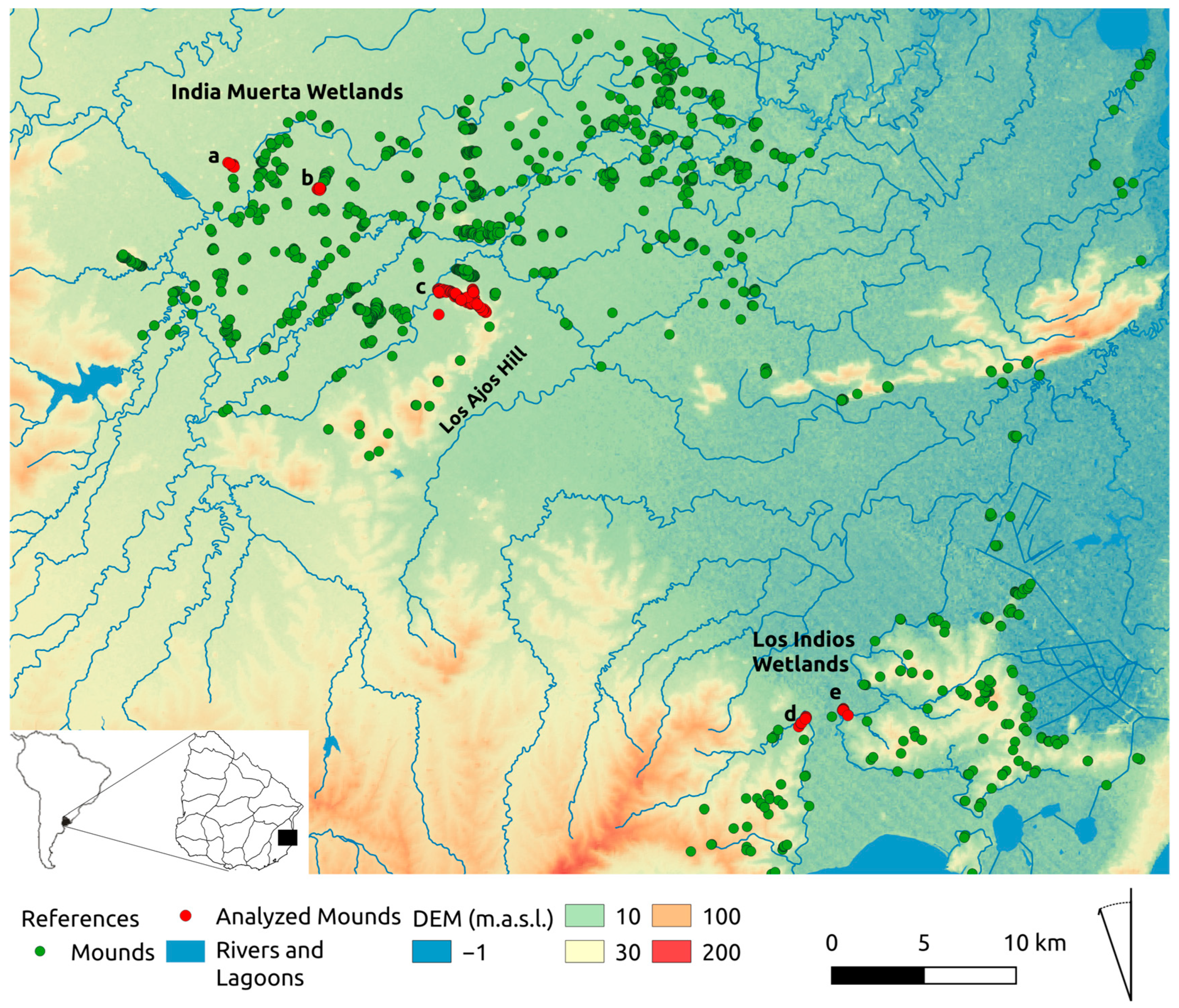
In the South American Atlantic lowlands, the construction of mounds dates back to ca. 4800 years cal BP in the India Muerta region, SE Uruguay [70,71,72]. The cerritos are anthropic constructions on the soil located in areas of low, middle and highland plains, in close relation to permanent wetlands and bodies of water [59,73]. Their use and construction lasted until the 16th century [74], and some of them were still used to bury indigenous people in the 18th century [75]. The groups that built and inhabited the mounds developed mixed economies based on hunting, fishing, gathering and the horticulture of corn, beans and squash [73,76,77,78]. During the 17th to 19th centuries, the SE and NE region of Uruguay, the main area of the dispersion of mounds, would have been occupied mainly by Guenoa-Minuano indigenous groups [79].
On a regional scale, mound sites present variable distributions and groupings. Some mounds were found isolated, but most appeared as sets or assemblages (Figure 1). The groups of mounds are generally distributed in low or medium plains, while the isolated or small groups are mainly distributed in hills and ridges. Distribution and location analyses have shown that the visual relationship between mound sites, visual control and access to resources and their relationship with transit routes are locational criteria that allow us to understand the spatial logic and the construction of the territory of these pre-colonial populations [67,80].
On a more detailed scale, the spatial arrangement within the assemblages show the progressive planning of space and the formation of monumental villages since ca. 4000–3000 years BP in some cases [72,81]. Within these villages, some architectural variability can be recognized among the earthworks (embankments, platforms and micro-reliefs), in addition to other spaces (plazas) and associated geoforms (ponds, canals and areas with anthropogenic soil loss). The earthen structures shows different degrees of transformations, which reaffirm the continuity of the occupation of these groups in the territory and the maintenance of the tradition of building and occupying earthen mounds through their use for habitation, ceremonial purposes, and as collective and generational cemeteries [65,70,72,73,75,82,83].
Previous works have noted the presence of recurrent orientations at different scales, on the one hand, at the scale of the assemblage and, on the other, of elongated mounds and/or small subgroups within larger assemblages [67,84]. The presence of circular spaces enclosed by mounds, dual and symmetrical distribution patterns and the alignments of mounds with recurrent orientations are some of the spatial configurations noted [67,81,84,85]. So far, these patterns have not been the subject of specific analyses, so it is not known what factors may be determining them.

1.3. Study Area

The study area is part of the Pampa biome [86] and the large Laguna Merín basin, a region also known as the Eastern Plains of Uruguay [87]. They are characterized by extensive floodplains and permanent wetlands dominated by temperate grasslands, hydrophilic vegetation in flooded areas, and native forests associated with watercourses, and in particular cases, with the mounds themselves. The predominant natural ecosystems are grasslands, wetlands and palm groves savannas [88]. The topographical characteristics induce great horizontal and zenithal visibility, where the hills and mountain ranges mark the lines of horizons of great amplitude.
From a paleoenvironmental and paleoclimatic perspective, the India Muerta wetlands found their stabilization after the transgressive maximum of the middle Holocene (ca. 5000 years BP), while the wetlands below +5 m.a.s.l. (i.e., Los Indios wetlands), were formed and stabilized after ca. 2500 years BP [55,89]. This correlates with the first colonization and intensive occupation of the marsh areas of India Muerta 5000 years ago, when the first mounds appeared. Later, after ca. 3000–2500 years BP, there would have been an important expansion of the mounds toward other areas closer to the coastal marshes, middle plains and lagoon edges [73].
In this work, we analyzed the orientations of the mounds and their astronomical relationships in five mound sites located in three different areas of the Department of Rocha (Uruguay). Two of these areas corresponded physiographically to floodplains, and the third was located in a mid-plain area: (a) the India Muerta wetlands area, which includes the mound sites García Ricci and Talitas, (b) Los Ajos Hill area, which includes the site Los Ajos and, (c) the Los Indios Wetlands area, which includes the Mound sites Los Indios A and B (Figure 2). In the selection of these five complexes, which include more than 100 mounds, different relief and environmental units are represented, as well as the most representative patterns of aggregation and distribution in the region. On the one hand, large mound complexes, such as Los Ajos, cover, the middle and high plains, medium-sized complexes, such as García Ricci and Los Talitas, located in the lower plains, and smaller complexes (such as Los Indios A and B) located in middle plains. On the other hand, several of these mounds have been the object of archaeological studies with contextualized archaeological information (function, chronology and formation processes, among others).
1—García Ricci mound site: It is located in the Bañados de India Muerta area. It is a group of nine mounds that occupy approximately 4.5 ha. The site is located in a floodplain with permanent marshes (15 m.a.s.l.). The site was declared a national historic monument in 2018. Although the site has not been excavated, it has some radiocarbon and Tl and OSL dating obtained from columns sampled from three mounds at the site that place its construction and use between ca 4000- and 1600 years BP and show contemporaneity in the construction of several mounds [90,91]. The dating conducted by us shows that at ca. 1800 years. BP, one of the mounds, was being used as a cemetery (Figure 3a and Table 1).
2—Talitas mound site: It is located about 5 km southeast of García Ricci, in the floodplain area of Bañados de India Muerta (15 m.a.s.l.). It is composed of 10 mounds that occupy approximately 2.6 ha (Figure 3b). The dating obtained from samples taken in some of the mounds has made it possible to establish the chronology of the site to be between ca. 3500- and 2500 years BP [90]. Recent excavations and analysis carried out by our team show that the construction and use of some mounds continued until ca. 1000 years BP [92]. The chronologies also confirm contemporaneity in the formation and use of, at least, the largest mounds of the site (Figure 3b and Table 1).
3—Los Ajos mound site: The Sierra de los Ajos mountain range surrounds the Bañados de India Muerta to the S-SE. The Los Ajos site is located 8 km from the Talitas site and 13 km from the García Ricci site. This site is formed by more than 70 mounds around 69 ha. approximately, which makes it one of the largest and most complex in the eastern region. The chronologies indicate that several mounds were used contemporaneously, between 4500 and 3200 years BP. It presents a linear distribution with a general NW-SE orientation accompanying a ridge of the sierra from the top to the wetland (between 15 and 40 m.a.s.l.). Research carried out by Iriarte [68,72,93] has allowed the recognition of different ground architectures (platforms, circular mounds and micro-reliefs) and spaces organized and delimited by the mounds (plaza) (Figure 3c). The site was recurrently occupied, with periods of reorganization and architectural diversification and the generalized and intentional growth of mounds. The activities developed in the mounds show domestic activity, orchards (Zea mayz L., Cucurbita spp.), and cemeteries [68,94] (Figure 3c and Table 1).
4—Los Indios mound site A: The archaeological site of Los Indios consists of two sets of two sets of mounds. Sites A and B are located in Bañado de Los Indios, on two peninsulas facing each other and separated by 1.5 km of wetland. Both groups are located on the edge of the marsh, between elevations of 10 and 30 m.a.s.l. [95,96]. On the eastern peninsula, there is a group of six mounds around 7 ha. approximately, called Los Indios A. This set has been excavated and has two mounds that are joined by an earth embankment that encloses a space that has been interpreted as a central square [81]. The mounds were distributed in two areas of the peninsula: one mound at the top of the peninsula and the other four in the lower part, on the banks of the marsh. The research shows a sustained recurrence in the human occupation of the peninsula. The first occupation by nomadic hunter-gatherer groups was ca. 8000 years BP [97,98,99]. Later, from ca. 3000 years BP, the construction of the first mounds began, which were used until ca. 700 years BP. During this period, there are contemporary episodes of construction, which were used in three of the mounds, and the appearance of other earthworks such as the embankment and 1 micro-relief with more recent chronologies ca. 1600 years BP. Domestic activities were documented in several mounds of the site, and, in three of them, their use as cemeteries was documented [65,100]. Based on the excavations carried out in this area, a cultural and chronological sequence was proposed, which, although it presents some small differences from the one proposed for Los Ajos, are essentially similar. (Figure 3d and Table 1)
5—Los Indios mound site B: In front of Los Indios A, two kilometers to the W-SW, is located Los Indios mound site B, which is made up of six mounds around 7 ha. approximately. These mounds have a nearly linear distribution along the interfluve with a general NE-SW orientation. The chronology of this site is not known. (Figure 3e)

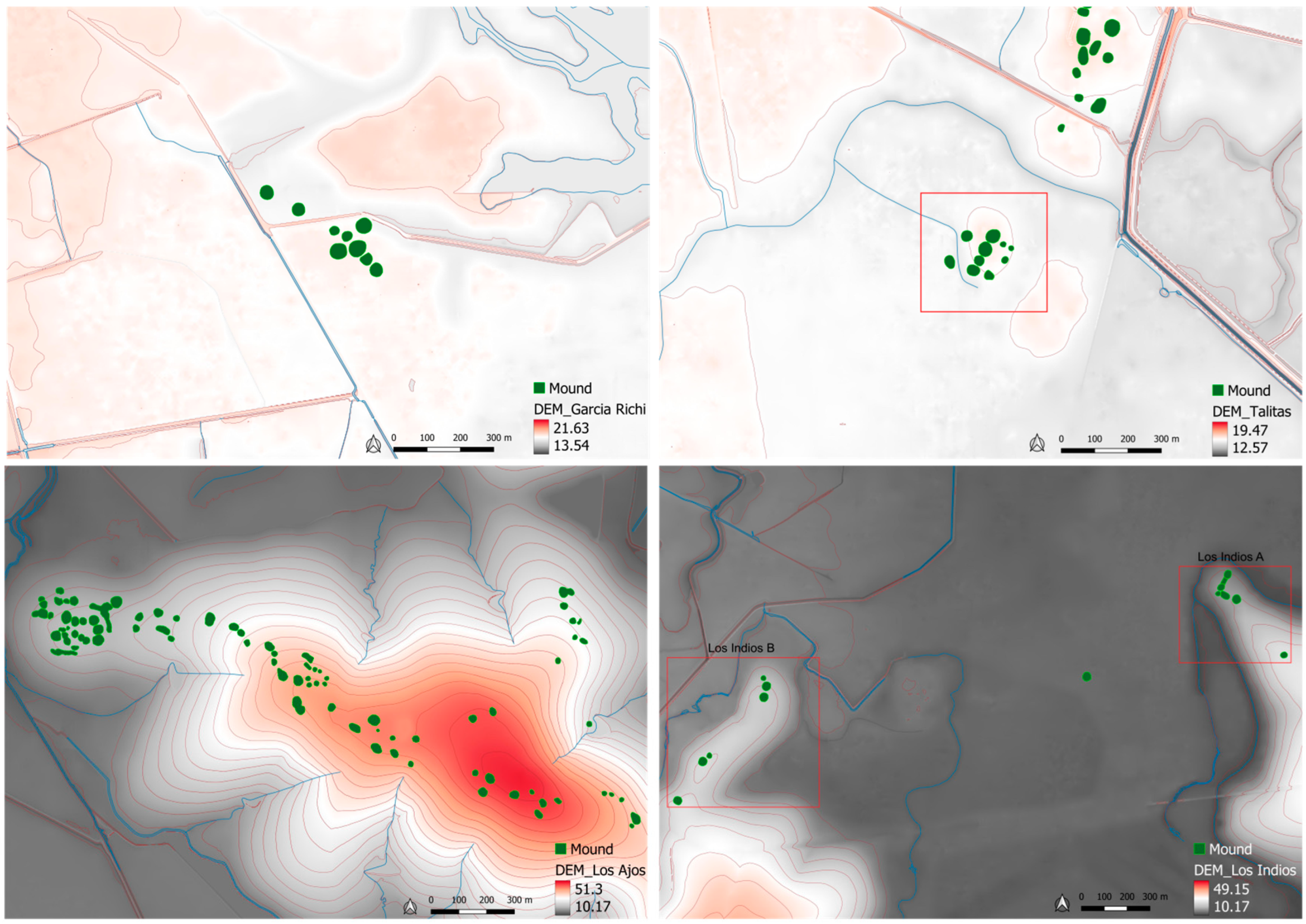
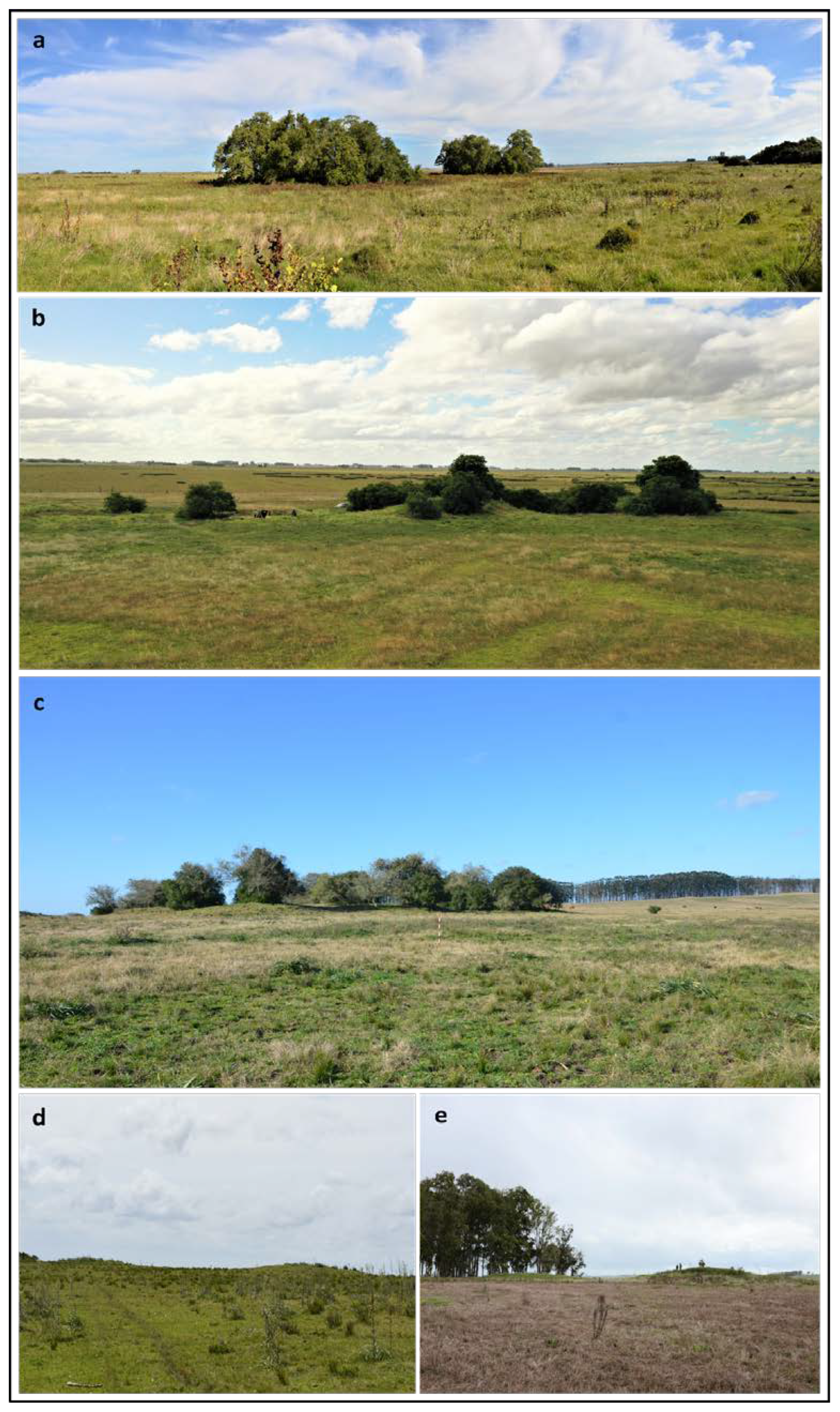
2. Materials and Methods
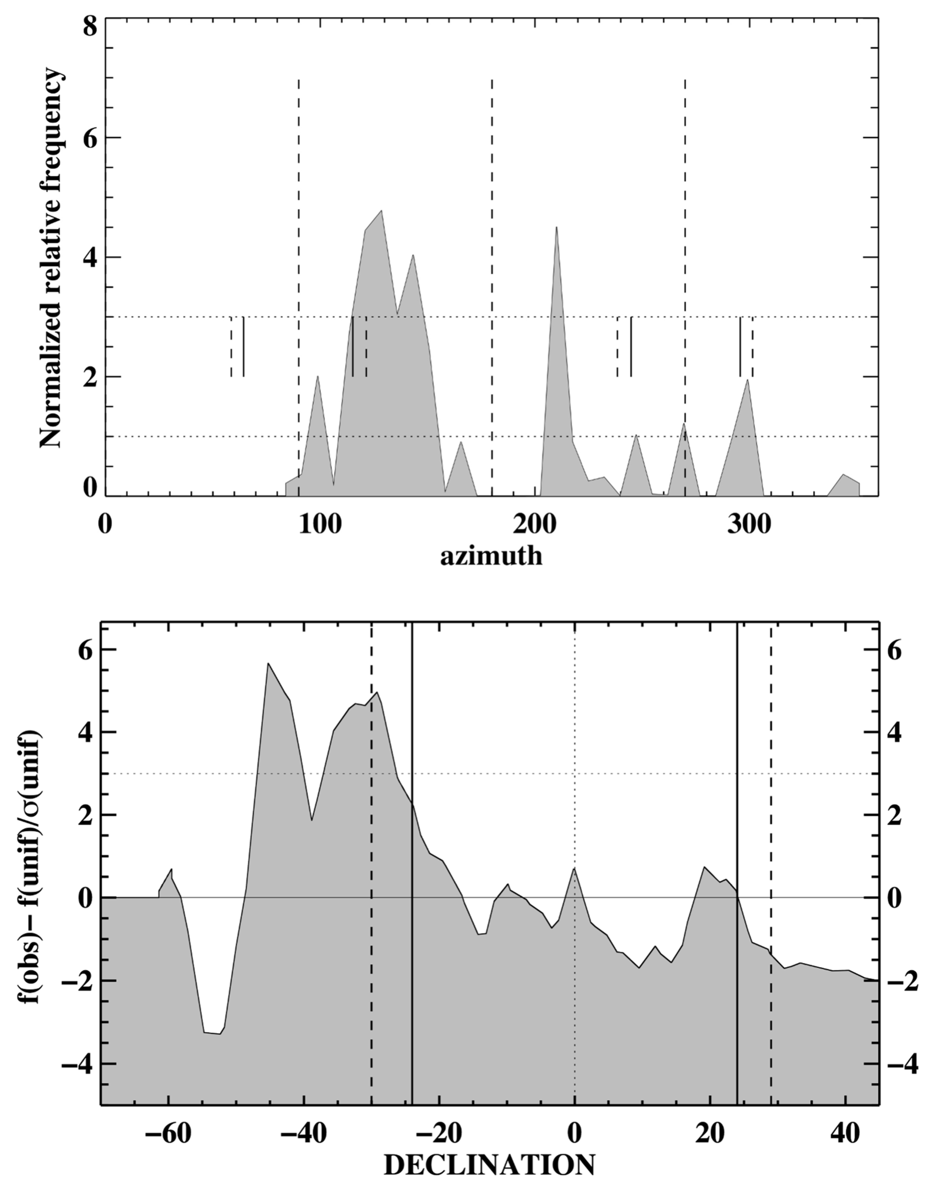
During our field campaign in April 2018, we visited the five sites analyzed in this paper. Most mounds appear roughly round in shape, and therefore, it is difficult to propose a particularly privileged direction in a single mound. However, the arrangement of the group tends to systematically appear in alignments.
The measurements were conducted after a careful inspection of each site to reveal the directions of interest. These include the relative position of each mound with respect to the others in the same group to obtain the general orientation of the group and the alignment with respect to nearby groups. In total, 100 orientation data were obtained from those five sites.
As indicated above, the objective of our study was primarily to investigate the locational pattern of the mounds with each other, especially for the linear arrangements of the mounds. We wanted to verify if there was a possible astronomical intentionality in those alignments.
It is interesting to note that while standing on top of a particular mound, several others could be seen, but only a handful was outlined against the background sky, defining the skyline. The critical importance of the horizon for the perception and knowledge of the sky has already been pointed out [101]. As indicated above, the prominent mounds do not appear to show a privileged direction, and the location is such that the horizon profiles do not show any prominent features. Those directions highlighted by the mounds and defining the skyline are the ones that we consider significant for the present study, as they could be somehow used to connect the land and sky directions from a particular spot. This assumes that while standing on top of a particular mound, we could see several other around us, but only the three in the image are on the edge of the slope defining a skyline. We are aware that the mounds that fulfill this criterion changed as we moved along the site. Other aspects, such as the visibility of the mounds from distant locations or from other mounds, as well as topographic prominence and insularity, have been pointed out as factors conditioning the location and site patterns [67,92]. In this sense, it is interesting to explore to what extent their relationship with elements of the sky may also constitute a criterion for the siting, location and organization of mounds.
The measurements were obtained standing on top of the mound nearly at its central position and measuring the direction to the top part of the central area of the other mounds visible from them. We took measurements for all the mounds visible from the one we were standing on and also recorded if the mound we measured the orientation to define the local skyline or not. In the subsequent analysis, we only take into consideration those orientations toward the mounds that defined the skyline. To conduct this, once the relevant direction was determined, we took measurements using a professional magnetic compass: a Suunto Tandem 360R. Each measurement was corrected from magnetic declination using two methods. First, we employed a global Earth model, which is available at https://www.ngdc.noaa.gov/geomag-web/ (accessed on 18 February 2023), and second, we verified the number of the readings obtained with selected topographical features that provided a handle on systematic errors. This allowed us to gain a robust handle on our measurement uncertainties so that, despite the fact that the compass readings had a ¼ error in azimuth and a ½ error in the angular altitude of the horizon measured in the line of sight, the astronomical declination error was less than 1°. Although such uncertainties might be important, given the kind of statistical analysis that we present here, we believe that this poses no big problem. Of course, this is the error in one single measurement [41,102].
This does not mean that the orientation is uniquely determined, given the measurement procedure presented above. Since the mounds are extended structures, they subtend a non-negligible angle, especially when the mounds are relatively close by. In those cases, such a range needs to be measured and recorded accordingly. The uncertainty in the orientation is thus considered in our analysis. With the measurements in each group, we obtained a general orientation pattern for the group. This is given in Table 1.
The data obtained, the corrected azimuth and horizon altitude, were then converted to the astronomical declination for each site, considering the local latitude of the site and correcting the horizon altitude from atmospheric refraction. To account for this effect, we employed a semi-empirical formula [103].
In the data analysis, we used a Kernel Density Estimator to create a probability density function. To do so, we employed a Gaussian Kernel with a bandwidth of twice the declination error; in this way, we included the error in the density estimation. We then performed a curvigram analysis. The histogram is built as the sum of each of those kernels and, thus, gives the concentration of declinations. The measured distribution (f(obs)) was compared with the concentrations expected if the orientations were uniformly distributed to any point in the horizon (f(unif)) and were scaled with respect to the variation expected in this distribution (σ(obs)). Vertical solid lines indicate the solstices, while dashed lines indicate the lunar extremes [41,104].

3. Results

Table 1 presents a summary of the data obtained during the field campaign. There we could observe the general orientation of each of the linear arrangements of mounds at each site. This is provided as an angular measurement of the mean azimuth (Ā). As indicated above, the orientations from each mound rendered a spread around this value, as indicated by the standard deviation σ(Ā). Finally, together with the latitude (ϕ) and the angular altitude of the horizon in the direction indicated by the mean azimuth, we could relate these directions to coordinates in the sky (declination, δ) and the range in azimuth implied by the standard deviation, which also translated into a range in declinations. Some of the possible targets for orientations could be some prominent Southern sky asterisms. One of the characteristics of the observation of stars near the horizon is that they are more affected by atmospheric extinction than other brighter objects. As a rule of thumb, we utilized the fact that a particular star will not be observable until it is above an altitude of the horizon that is at least equal to its visual apparent magnitude. Therefore, we included the modified values of the declination for such an altitude.
First, it is worth noting that given the selection and measurement criteria mentioned above, the five groups have systematic orientations toward the southern part of the horizon and, more specifically, either southwest or southeast. In fact, the remarkable fact of these orientations is that considering the mean declination, all five seem to be facing parts of the sky only 10° apart. When we take into account the declination ranges, all of them seem to be overlapping (Figure 4).
Figure 4 provides a more graphical view of these results. There we indicate by color ovals the area of the sky (in declination) versus the chronology of the sites. The data provided in Table 1 transfer into the major axes of the ellipses. To compare with a few objects, the dashed horizontal line provides the southernmost limit of the Moon, while the horizontal dotted line is the December solstice for the Sun. The grey band is the area of the sky covered by the Southern Cross. The change with time is due to the effect of the precession of the equinoxes, which does not affect the positions of the Sun or the Moon. We can see that all sites are consistent with the positions of the Southern Cross at the different epochs. The northern side of García Ricci would be consistent with the Moon, a fact that would also be marginally true for Los Ajos. A more detailed analysis can be conducted when considering the orientations measured from each mound individually and performing a histogram analysis, as described above (Figure 5).
The top diagram shows an azimuth histogram and highlights what was hinted at in the inspection of Table 1: that most mounds seem to display conspicuous visual lines where they are seen to outline against the sky toward the southeast or southwest. In particular, it is interesting that the spread, although non-negligible, is admittedly low for these kinds of data.
When comparing them to astronomical objects, it is interesting that most seem to be outside the azimuth ranges where we can see the Sun on the horizon, either rising or setting, as we have indicated above. Indeed, there are a small number of them that lie inside these ranges, and in particular cases, they seem to be in interesting directions, such as equinoxes or solstices. However, the small number of them prevents us from generalizing such results. What is more interesting seems to be the possible connection with the Moon indicated by a concentration close to the southernmost rising of the Moon.
To verify such ideas or propose other alternatives, we must consider the astronomical declination; this can be seen in the second figure (Figure 5). There we may observe two main concentrations. The most conspicuous one is centered at a declination of −45°, while the second appears to be centered at −30°. The second could be related to the southernmost position of the Moon. Indeed, this could be an intriguing possibility. If we consider the full Moon as the relevant phase for the observation, this could correspond to the full Moon before and after the June solstice. However, the most prominent concentration seems to be toward −45°. This could be related to the general value of the declination of the Southern Cross for epochs around 3000 to 2500 years BP (considering that, here, the region of the sky defined by the four brightest stars of the asterism, in this period of time α Cru changes from −45° to −49°, while β Cru changes from −41° to −46°).

4. Discussion

From the statistical analysis of the nearly 100 measurements made in five sets of mounds located in different areas of the eastern region of Uruguay, two significant orientations stand out. On the one hand, there is the relationship between the orientations with the Southern Cross and the area of the Milky Way where it is located, and on the other hand, with the full Moon during the June solstice. In the first case, the prominent concentration (produced towards −45° in declination) that occurred for all the sites analyzed could be related to the declination of the Southern Cross for epochs ca. 3000 to 2500 years BP. Most of the mounds are outlined against the sky toward the southeast or southwest, coinciding with what we could assimilate with the heliacal sunrise and sunset of the Southern Cross in this region of South America (Figure 6). It should be noted that the heliacal rising for such a period of time would be slightly after that same June solstice. The second significant concentration (centered at −30°) is related to the southernmost position of the full Moon that would occur before and after the June solstice, coinciding with the beginning of the rainy season and winter in this South American region. By investigating the significance and relevance of the Southern Cross and the full Moon of the June solstice in different South American cultures, we can see that both elements play a key role in indigenous worldviews. In order to delve deeper into the importance and meanings given to both, it is necessary to review the ethnographic, ethnohistoric and archaeological literature.
With regional variations, there are sets of astronomical knowledge that materialize with time and space arrangements and that show some general elements shared by several ethnic groups and distant regions of the South American continent [5,105]. In this common substratum appear, among others, the apparent movements of the Sun, the Moon, Venus, the Southern Cross, the Pleiades and the Milky Way in the celestial vault and in their relationship with the terrestrial plane and the cosmos of various groups. The survival of this knowledge over time and in distant regions is remarkable. For example, part of the astronomical knowledge of the present-day Guarani of southern Brazil is very similar to the Tupinambá knowledge system of Maranhão described by D’Abbeville in 1614; both are separated by more than 3000 km and by almost 400 years (see [105]). However, the dynamic nature of these cosmovisions also requires caution regarding generalizations to the past made on the basis of present-day or even colonial references [3].
One of the situations highlighted is the importance of the solstice, particularly the June solstice, among the Moqoit, Qom, Guaraní and Mapuche [3,4,5,23,24]. This event, as well as the visibility of the Southern Cross, is related to the cold and frosty season in the Chaco region; in addition, in our study area, it is accompanied by frequent rainfall. These are necessary conditions for the fertility of spring and, therefore, are highly significant within the annual cycle of the indigenous groups. The relationship identified between the Uruguayan mounds with the full Moon and the Southern Cross during the winter solstice (June) is suggestive if we consider that it coincides with the coldest time of the year and with the greatest permanence of humidity in the plains. In general, there is a very marked contrast between the hot season and the cold season that substantially changes the local landscape. If we take into account that in indigenous cosmovisions, these seasonal changes are frequently associated with the beginning of the cosmos and fertility, the archaeoastronomical relationship identified could be marking something similar for this wetland region.

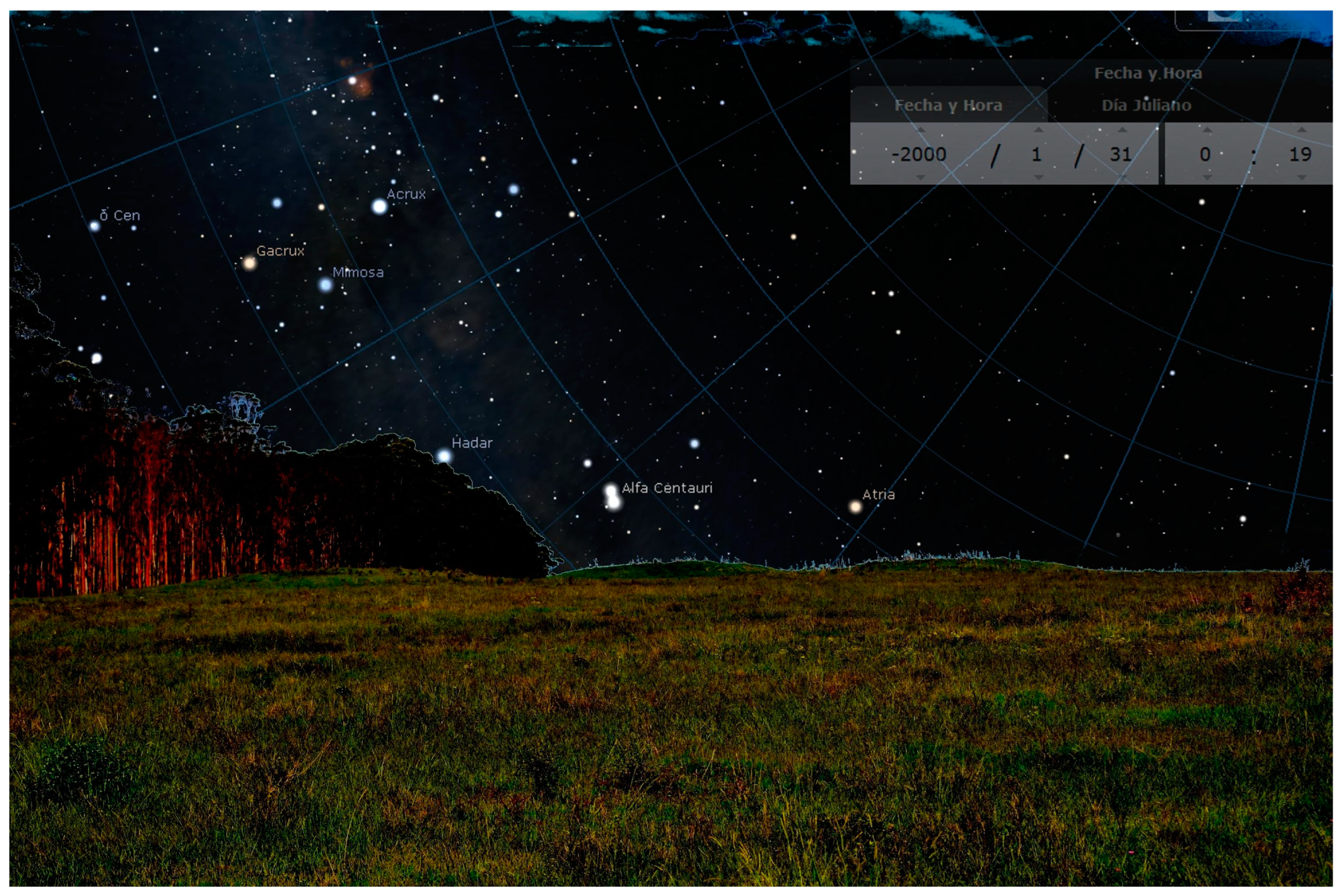
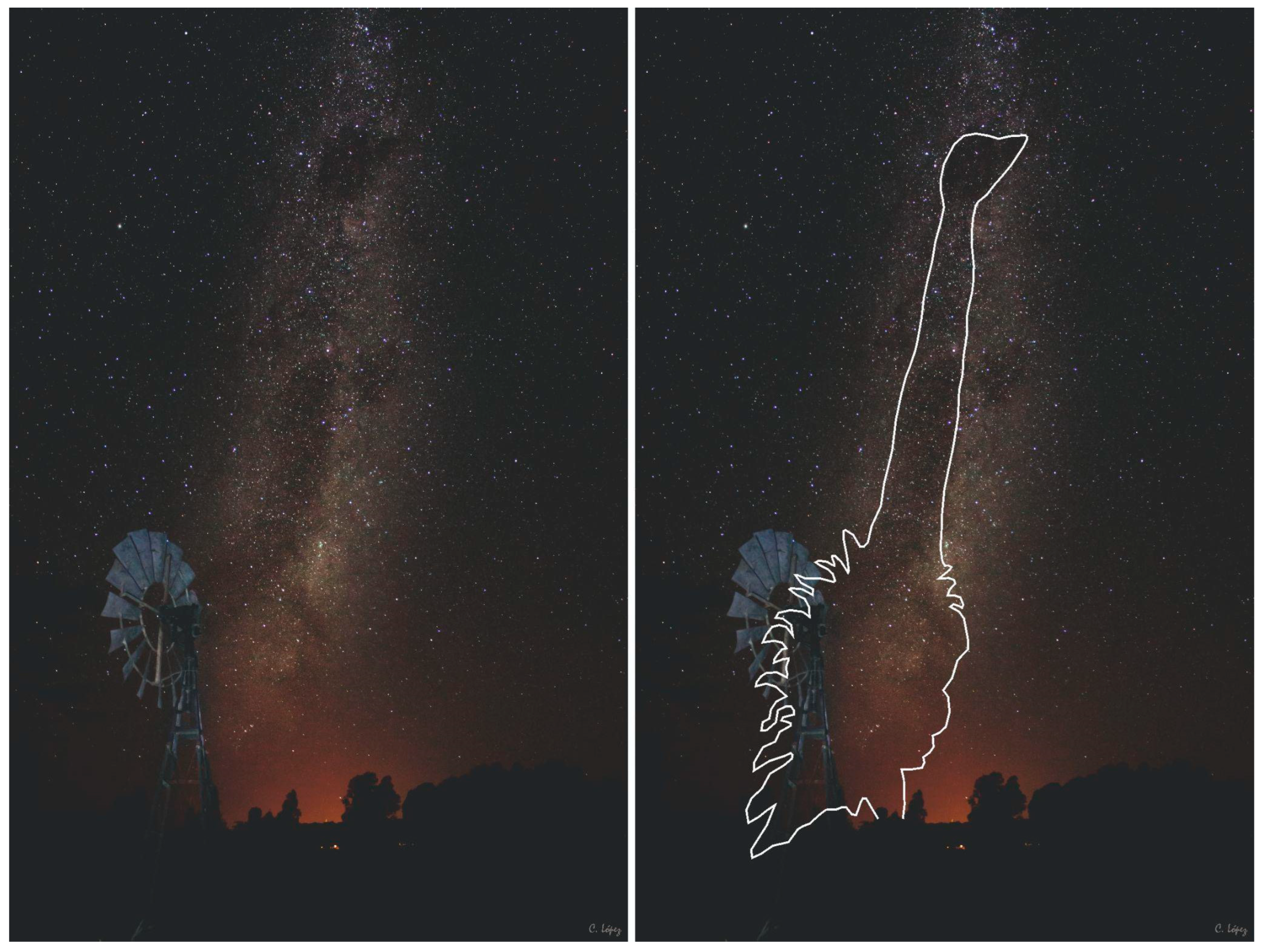
4.1. The Ñandú (Rhea), the Southern Cross and the Milky Way

The constellation of the Southern Cross is an asterism of great importance among the Bororo, Tukano, Tupinambas, Tupiguaraní, Tehuelche, Mapuche, Tembé, Tenetehara, Charrúa and Moqoit, among others [15,19,20,21,22,25]. Despite its recognition as an individualized constellation, it is strongly linked to the Milky Way, sharing meanings that give sense to the understanding of the cosmos in several indigenous societies [3]. It has also been syncretically incorporated into the worldview of Creoles in the Chaco region in recent times [30]. As noted in the previous section, the case of the Uruguayan Mounds appears as another of the most significant orientations.
In this line, several relevant arguments emerge from the analysis of ethnographic, ethnohistoric and archaeological information in different South American contexts. One of the most interesting aspects is the relational conjunction of meanings that link the Southern Cross, the Milky Way and the figure of an ostrich, currently known in the study area as Ñandú (Rhea americana). This is to the point that the same word is sometimes used to designate both the biological species and the constellation of the Southern Cross or even the Milky Way, both of which represent this great bird in the sky. Pári Búrea is the imprint of Ñandú and the Southern Cross among the Bororo [19]; Mañic or Amanic among the Moqoit [16,26]; Peú by the Abipones according to Paucke [26], Guyra Nhandu among the Guaraní [106]; Yandoutin among the Tupinambá [21], Choike in the Patagonian area and southern Chile [4], Berá among the Charrúas [107].
Since the beginning of the 20th century, Lehmann-Nietsche [25] has pointed out the importance among the Toba and Moqoit of the celestial Mañic, viewed as a master of the rheas in the Chaco region. This was represented in the sky by two different asterisms: the Stellar Mañic, identified with the Southern Cross, and the Lacteal Mañic, which corresponds to an extensive region of the sky formed by dark areas of the Milky Way, where the head of the Mañic is associated with the Coal Sack region and its body extends to dark areas in the constellation of Scorpio [5,23]. In that representation, Alpha and Beta Centauri are dogs that chase her and bite her neck [108], although, in other regions, they are boleadoras [109,110]. José Vieira Couto de Magalhaes [20] (pp. 78–79) records a similar description in the diary of his journey through Brazil: “One night, they noticed that one of the spots in the sky (which is next to the constellation of the Cross) presented the head of an ostrich, that as the night progressed, the continuation of the animal appeared in the Milky Way as a neck and then the body of that bird”.
In general terms, this asterism is presented in the Lowlands, with regional variations, as being linked to the Rheidae family, which in South America has two species: Rhea americana (common rhea) and Rhea pennata (rhea, rhea petiso or Darwin’s rhea) [111,112]. It is a gregarious and omnivorous Neotropical species characteristic of open grasslands and sparsely wooded areas [113]. During the breeding season, in early spring, the females separate into small groups and the males become territorial as they are the ones to incubate the eggs. There are numerous accounts in the chronicles of travelers and naturalists that describe the hunting of this bird in colonial times, using horses and boleadoras, and the intensive use of different parts (meat, fat, bones, feathers, tendons, etc.) of this bird [109,114]. Both species are present in the faunal record of archaeological sites, mainly through eggshell remains [109,115]; as we can see below, there are several questions surrounding the frequency of bone representation in the archaeological site record in Pampa-Patagonia. On the other hand, several lines of evidence indicate that the rhea is a powerful spiritual and symbolic animal that is frequently present in the ceremonies, rituals and material culture of several indigenous groups [4,109,114,116].
The figure of the Ñandú-Southern Cross is represented on instruments and animals used in the Mapuche ceremonies of Ngillatun or Kamarikun [4] and even has a specific ritual dance known as the choique purrun [109]. In these ceremonies, the Mapuche ceremonial drum appears divided into four, with each end of the cross topped by a tridigit figure that refers to the legs of the rhea and is also related to certain food taboos, as seen in the Chaco, where young Moqoit were not allowed to eat even the meat of the rhea’s wing. The bones of the legs and wings were used to make flutes, which were used in ceremonies and rituals among the Moqoit and Tobas [26] (p. 329).
Knowledge and representations of the sky are manifested, at least in part, in different materiality that supports memory [3]. Architecture is a part of these this guide, giving order and contributing to the processes of enculturation and the formation of habitus [117]. In this sense, the relationship of the orientations of the groups of mounds analyzed here with the Southern Cross-Milky Way allows us to raise the possibility that we are faced with the integration of knowledge of the sky in the form of the social construction of inhabited space and the configuration of the landscape.

4.2. Knowledge Systems about Time and Space

Several studies show the importance of the links between asterisms and astronomical cycles and how these are part of a complex system where climatic, biological, productive and social cycles converge and must be interpreted together [8,23,118,119]. The heliacal rising or settings of various asterisms are frequently related to this type of phenomenon, as well as the zenithal passage of the Sun in tropical regions [5,11,17,24,27,120,121]. From this perspective, both the Southern Cross and the Milky Way have been recognized as references to time, annual seasonal cycles and orientation [30,105]. In both cases, due to the movement of the Earth, they change their position during the night and also throughout the year. In different regions of Brazil, its use for orientation and calendar purposes has been documented when it is in a position exactly above the observer’s head (zenith), which occurs on dates close to the equinoxes of March and September [122]. The Moqoit of the Chaco knew the time within the annual cycle when the heliacal rise of many stars occurred and used the position of the Milky Way, the Magellanic clouds and the stars to orient themselves and calculate the time. The Moon was also used to measure time; in fact, the word shiraigo (Moon) is used to designate the month [5]. On the other hand, the observation at a certain time of the year of the Ñandú (mañic lacteal) formed by the dark clouds is associated with periods of rain [30].
The relationship between the Southern Cross—Ñandú—and natural cycles has also been reproduced in recent times by European settlers (Creoles) and their descendants in agricultural colonies in the southern Chaco, showing the survival and syncretism of indigenous knowledge with their own [30]. The Ñandú plays a symbolic role for them and is evident in the Santa Rosa festival (30 August) associated with the renewal of the times. It is also interesting how the reproductive cycle and egg-laying of the Ñandú played a key cultural role as an indicator of the renewal of the Moqoit annual cycle [123].
Further, the central place of the Milky Way as a structuring element of the sky among South American indigenous peoples is indisputable. López and Altman [3] systematize the way in which the Milky Way is represented in indigenous cosmovisions. Among them, it appears as a tree [108,124,125], a river [4,108,126,127,128], a road [4,108,126,128], a whirlwind [23,126] or a tunnel [23,108]. This asterism has links with shamanic activity because it constitutes a concentrating pole of power [3,108].
In the case of the Moqoit [108], the Mañic (master of the rheas), after taking refuge under the roots of an ombú tree in the wake of being chased and cornered by a “powerful” man, climbed up the trunk of the ombú (the world tree) to the sky. Today, Mañic looks similar to the dark clouds of the Milky Way, with his head in the Coal Sack, and Alpha and Beta Centauri are the dogs chasing him. Among the Moqoit, nayic means path, and the Milky Way is the path that the Mañic follows in his flight towards the sky, and the Southern Cross is his paw print [25]. Additionally, for Patagonia, Faulkner [22] (p. 47) said, “… that the stars are the ancient Indians, and that the Milky Way is the field where the ostriches go hunting, whose feathers are the two southern clouds”. According to López and Giménez [108], these stories constitute a kind of serial narrative linked to the story of the “Mañic hunt”, which is “strung” on the common thread of the Milky Way.
In this way, by invoking the significance of these elements of the sky and their association with the Ñandú, we can suggest that the orientation identified in our work could be highly significant. The orientation of the mounds and their link with the Southern Cross may be related to ideas similar or close to those put forward by other South American indigenous groups (Figure 7). The materialization of these relationships between these asterisms and human spatiality is also found in archaeological sites. The archaeoastronomical studies carried out in the Moxos plains in Bolivia provide interesting data in this sense. Belmonte and Barba [44] suggest that the lagoons present in their study area have been anthropically modified and were deliberately orientated in accordance with certain bright stars, especially α and β Centauri. These stars may have marked selected moments in the local climatic or economic cycle and may well have had great symbolic significance in the cosmovision of the ancient Moxeño culture. Additionally, they also consider, from analogies with Guarani groups, the possibility that the rhea had an important role in these communities. It is also noteworthy that the rhea is present in the rock art of the region.

4.3. Presence of Ñandú (Rhea americana) in Archaeological Sites

All the above indicates the strong link between the Southern Cross, the Milky Way and the Ñandú and how this relationship structured and permeated the cosmovision of several South American native peoples. The presence of rheids in the archaeological record is another source of information that a priori allows us in order to approach the role of this species for the indigenous communities that built the mounds. Different zooarchaeological studies in the Pampean region coincide with pointing out the low presence of rheids in archaeological sites in the Pampa, Patagonia and NW Sierras [109,115,129,130,131,132], which, in principle, is contradictory to the chronicles written after the conquest, where the intensive exploitation and consumption of these birds is noted [133,134,135]. This same situation occurs in the faunal record of the mounds in the region studied, where the presence of ostrich bone is quite marginal, with eggshell fragments being more frequent than bone remains [136]. Something similar occurred in coastal sites with occupations around 3000 years BP, where only eggshells are present [137]. The few remains that appear in total in the excavated mounds (N = 23) coincide with elements of the hind limbs—tibiotarsus, tarsometatarsus and phalanges, one of which was used to make a bone tool of the awl type [136,138,139]. In most of these studies, the possible causes of this under-representation are posed as a question, on the understanding that it is not a taphonomic or conservation problem.
The scarce and differential representation of skeletal parts (tarsi and metatarsi) has been argued as a possible consequence of differential exploitation or taphonomic aspects that led to the differential preservation of the bones or that the rheas were hunted in special places that have not been identified so far, or that their hunting would have been very difficult [140,141,142]. Some indigenous tales describe the mythical hunt of the celestial rhea (which should not be equated with the common rhea), describing how they make it flee into the sky [108,118,143]. For the Chaco region, other authors describe different indigenous techniques for hunting the rhea, some of them “of the ancients”, such as hunting on foot with bow and arrow and camouflage (Figure 5 [144]) or with bolas, in the colonial period on horseback and, more recently, with firearms. The latter was promoted by the commercialization of their feathers [144]. Considering the relevance of this animal in the indigenous cosmovision, it is possible that the absence or scarce presence of the Ñandú in the archaeological record may be linked to certain restrictions or taboos that limit its ingestion or consumption, either totally or partially or for certain groups of people [144] or also due to its consideration as a mythical animal of power. Dealing with this idea opens up the possibility of problematizing the economic and binary approaches that permeate modern ontologies as a way of recognizing the complexity of the models and sets of rules that can operate on forms of appropriation, as well as the exploitation and management of resources [145] and the construction of reality [146]. Among the Qom of the Gran Chaco region, the consumption of Ñandú meat is forbidden by mothers and fathers of newborns, just as Ñandú fat is also forbidden for Qom women during menstruation, menarche and pregnancy [144]. The Ñandú also appears to be linked to ritual and funerary contexts in Pampean sites such as Chenque 1, where beads made from Rheidae eggshells were recovered as part of the funerary offerings of the site between 1000 and 370 years BP [147]. At rock art sites in the Sierra de Ventania, motifs known as tridigites have also been documented, representing footprints assigned to the Rheidae, which have been interpreted as plastic expressions that highlight the symbolic character of this animal in indigenous Pampean societies [109].

5. Conclusions

The archaeoastronomical analysis of the orientations of five sets of mounds located in India Muerta wetlands has allowed us to propose, for dates around 3000–2000 years BP, the relevance of the heliacal positions of the Southern Cross and the Milky Way and the full Moon of the winter solstice as factors in the construction of mound sites and the organization of space and time among the mound-building peoples. These relationships must be understood in the broader context provided by the body of knowledge of the sky and cosmovisions of South American indigenous peoples.
The observation of these asterisms and their association with the passage of time, annual cycles and seasonal changes (particularly the rainy season) and with specific orientations reflect the key cultural role they may have played in the lives of these peoples. In the case of the Uruguayan Mounds, this knowledge is key if we consider the environmental context and the seasonal variations of the flooded ecosystems where the sites analyzed are located. The Talitas and García Ricci assemblages are located in the lowlands, while the other mound sites are located at higher altitudes, occupying small ridges circumscribed by wetlands. The observation and materialization of this knowledge of the sky through architecture on land was part of the processes of structuring and reproducing social life, in which the Moon, the Southern Cross and the Milky Way undoubtedly played a central role.
Of course, these results are based on a restricted sample, and therefore, the results must be understood as preliminary. These results, however, are solid enough to prompt us to propose a future study on a larger sample, most possibly based on a systematic exploration via high-resolution DTM’s that may allow us to systematize the data-gathering process in this and other areas with a large number of mound clusters. By proposing such a subsequent study, we aim to unveil if such trends are kept in larger samples, if there is further knowledge of the sky present in the construction of mounds, and in the archaeological record of mounds. Nevertheless, these results open up new questions about the role of indigenous earthen architecture as a technology for inhabiting wetlands: does the association with the Southern Cross—Milky Way appear throughout the South American lowland region where earthen mounds are distributed? Does it also manifest itself with other chronologies? Are there other relevant orientations in the construction of mounds sites? Do some of this knowledge persist today in local rural populations? Further archaeoastronomical analyses of the organization of mound site spaces should focus on deepening these links and answering these and other questions. In any case, these initial results constitute a contribution to the study of the astronomical knowledge systems and worldviews of the native peoples of South America.
The close and strongly recurrent relationship of the Southern Cross and Milky Way with the Ñandú raises other aspects to be considered in studies of archaeological landscapes in the region. The key cultural role of this bird in several South American indigenous contexts opens up new ways to continue exploring and connecting various aspects of its figure, both as an economic resource and as a cultural and symbolic role in the cosmovisions of indigenous peoples. Some of the ethnographic evidence presented in relation to recent taboos suggest that, in the past, other taboos may also have been the cause of restricted consumption resulting in a scarce archaeological record. The exploration of these issues is a challenge for future research. Most importantly, this work invites us to integrate, within our analyses, relational perspectives, where materiality is thought of as a reproduction and manifestation of ideas, intentions and social relations to the land of human and non-human beings and elements of power. It is also a way of showing the agency of indigenous societies in shaping past and present landscapes.
The analysis carried out contributes to a multi-ontological and relational understanding of the landscape, where its various planes are integrated, incorporating the celestial plane as part of the social construction of territory in past and present societies. In this sense, the spatial organization of mound sites can be understood as spaces of action that mediate between concrete human experience and the centers of meaning that structure social life, in which the sky undoubtedly plays a central role. The mound sites, and the spatiality they construct, take on other meanings from this perspective of landscape archaeology as lived spaces produced by experience and constituted by the conjunction of heterogeneous elements, including human and non-human and tangible-inert, organic-social and imaginary, with variable temporality, which occurs in a situated manner. It is a current challenge to incorporate these conceptualizations of landscape and explore their resulting implications as a critical contribution to various fields of application in social and humanities knowledge, such as environmental and heritage management, landscape studies, territorial planning and biodiversity conservation.

Author Contributions

Conceptualization, C.G., A.C.G.-G. and N.G.; methodology and formal analysis, A.C.G.-G., N.G. and C.G.; investigation, C.G., A.C.G.-G., N.G., C.C.-C. and M.S.; writing—review and editing, C.G., A.C.G.-G., N.G. and C.C.-C.; funding acquisition C.G. and A.C.G.-G. All authors participated in field data collection. All authors have read and agreed to the published version of the manuscript.

Funding

This research was funded by the Comisión Sectorial de Investigaciones Científicas (CSIC)—funded research programme in Landscape Archaeology and Heritage GRUPOS I+D 2019–2023. It was also supported by the Spanish ministry of Science and Innovation through grant PID2020-115940GB-C22 ’Orientatio ad Sidera V’ and Agencia Nacional de Investigación e Innovación (ANII) Grants POS_FMV_2018_1_1007772.

Institutional Review Board Statement

Not applicable.

Informed Consent Statement

Not applicable.

Data Availability Statement

Data published in this article are available from the authors by request.

Acknowledgments

We would like to thank Cristian López, Astrophotographer, exhibitor and writer of articles on astrophotography, for providing one of the images included in this article. The photograph was taken at midnight on 14 February 2016 when the Mañik walks at ground level in the Pampas. It was taken in “Yamay Turismo responsable” (Pardo town, Buenos Aires). The image was obtained with a Canon T3 reflex camera, on a tripod. Lens 18–55 at 18 mm. ISO 3.200 and 20 s of exposure. We are grateful to the reviewers whose comments and suggestions helped to substantially improve the work.

Conflicts of Interest

The authors declare no conflict of interest.

References

  1. Aveni, A.F.; Urton, G. Ethnoastronomy and Archaeoastronomy in the American Tropics; The New York Academy of Sciences: New York, NY, USA, 1982. [Google Scholar]
  2. López, A. Astronomy in the Chaco Region, Argentina. In Handbook of Archaeoastronomy and Ethnoastronomy; Ruggles, C., Ed.; Springer: New York, NY, USA, 2015; pp. 987–995. [Google Scholar]
  3. López, A.; Altman, A. Cosmo-Logics in Contemporary Lowland South America. J. Skyscape Archaeol. 2022, 7, 269–297. [Google Scholar] [CrossRef]
  4. Pozo, G.; Canio, M. Astronomía y Cosmología Mapuche; Ocho Libros Editores: Santiago, Chile, 2014. [Google Scholar]
  5. Giménez-Benítez, S.; López, A.; Granada, A. Astronomía aborigen del Chaco: Mocovíes I. La noción de nayic (camino) como eje estructurador. Scr. Ethnol. 2002, 23, 39–48. [Google Scholar]
  6. Giménez-Benitez, S.; Corrado, G. El muro segmentado de El Shincal como marcador solar. Rev. Mus. Antropol. 2022, 15, 133–144. [Google Scholar] [CrossRef]
  7. Lima, F.; Barbosa, P.; Jafelice, L.; Borges, L. Relações céu-terra entre os indígenas no Brasil: Distintos céus, diferentes olhares. In História da Astronomia no Brasil; Matsuura, O., Ed.; CEPE: Recife, Brasil, 2014; pp. 81–130. [Google Scholar]
  8. Cardoso, W.T. O Céu dos Tukano na Escola Yupuri: Construindo um Calendário Dinâmico. Ph.D. Thesis, Pontifícia Universidade Católica de São Paulo, São Paulo, Brasil, 2007. [Google Scholar]
  9. Aveni, A.F. Archaeoastronomy in the Ancient Americas. J. Archaeol. Res. 2003, 11, 149–191. [Google Scholar] [CrossRef]
  10. Iwaniszewski, S.; Vasconcellos, R.M.; Gilewski, M. La Vida Bajo el Cielo Estrellado: La Arqueoastronomía y Etnoastronomía en Latinoamérica; Centrum Badań Andyjskich Uniwersytetu Warszawskiego: Warszawa, Poland, 2021. [Google Scholar]
  11. Magaña, E. Carib tribal astronomy. Soc. Sci. Inf. 1984, 23, 341–368. [Google Scholar] [CrossRef]
  12. Romain, W.F. Following the Milky Way Path of Souls: An Archaeoastronomic Assessment of Cahokia’s Main Site Axis and Rattlesnake Causeway. J. Skyscape Archaeol. 2021, 7, 187–212. [Google Scholar] [CrossRef]
  13. Ruggles, C.; Urton, G. Skywatching in the Ancient World: New Perspectives in Cultural Astronomy; University Press of Colorado: Colorado, CO, USA, 2007. [Google Scholar]
  14. Sprajc, I. Venus, Lluvia y Maíz: Simbolismo Y Astronomía en la Cosmovisión Mesoamericana; Instituto Nacional de Antropología e Historia México: Mexico, Mexico, 1998. [Google Scholar]
  15. Urton, G. At the Crossroads of the Earth and the Sky: An Andean Cosmology; University of Texas Press: Austin, TX, USA, 1981. [Google Scholar]
  16. López, A.; Giménez-Benítez, S. Mesurer chez les Mocovís (Argentine): Influences occidentales. Ethnol. Fr. 2005, 35, 445–456. [Google Scholar] [CrossRef]
  17. Magaña, E. Contribuciones al Estudio de la Mitologia y Astronomia de los Indios de las Guayanas; CEDLA. Latin American Studies: Amsterdam, The Netherlands, 1987. [Google Scholar]
  18. Giménez-Benítez, S. Selk╹nam Astronomy. In Handbook of Archaeoastronomy and Ethnoastronomy; Ruggles, C., Ed.; Springer: New York, NY, USA, 2015; pp. 1005–1009. [Google Scholar]
  19. Albisetti, C.; Venturelli, A. Enciclopedia Bororo; Instituto de Investigaciones Etnográficas: Campo Grande, Brasil, 1962.
  20. Couto de Magalhaes, J.V. O Selvagem, 3rd ed.; Cia. Editora Nacional: São Paulo, Brasil, 1935. [Google Scholar]
  21. D’Abbeville, C. História da Missão dos Padres Capuchinhos na Ilha do Maranhão e Terras Circunvizinhas; Livraria Martins Editora: São Paulo, Brasil, 1945. [Google Scholar]
  22. Falkner, T. Descripción de Patagonia y de las Partes Adyacentes de la América Meridional, que Contiene una razÓn del suelo, Producciones, Animales, Valles, Montañas, Ríos, Lagunas; Imprenta del Estado: Buenos Aires, Argentina, 1835. [Google Scholar]
  23. López, A. La Virgen, el Árbol y la Serpiente. Cielos e Identidades en Comunidades Mocovíes del Chaco. Ph.D. Thesis, Facultad de Filosofía y Letras, Universidad de Buenos Aires, Buenos Aires, Argentina, 2009. [Google Scholar]
  24. Pereira, G. “Chiriguano” Astronomy-Venus and a Guarani New Year. In Handbook of Archaeoastronomy and Ethnoastronomy; Ruggles, C., Ed.; Springer: New York, NY, USA, 2015; pp. 967–973. [Google Scholar]
  25. Lehman-Nietsche, R. La astronomía de los tobas. Rev. Mus. Plata 1923, 27, 267–285. [Google Scholar]
  26. Paucke, F. Hacia Allá y Para Acá; Ministerio de Innovación y Cultura de la Provincia de Santa Fe: Santa Fe, Argentina, 2010. [Google Scholar]
  27. Fabian, S.M. Space-Time of the Bororo of Brazil; University Press of Florida: Gainesville, FL, USA, 1992. [Google Scholar]
  28. Lery, J. Viagem à Terra do Brasil; Itatiaia: São Paulo, Brasil, 1980. [Google Scholar]
  29. Lima, F.P.; Figueirôa, S.F. Etnoastronomia no Brasil: A contribuição de Charles Frederick Hartt e José Vieira Couto de Magalhães. Bol. Mus. Para. EmÍLio Goeldi Ciênc Hum. 2010, 5, 295–314. [Google Scholar] [CrossRef] [Green Version]
  30. Mudrik, A. “El ñandú” en el cielo: Etnoastronomía de gringos, criollos e indígenas y las representaciones celestes de Rhea americana en el sur del Chaco argentino. Hornero 2017, 32, 7–17. [Google Scholar] [CrossRef]
  31. Hugh-Jones, C. From the Milk River: Spatial and Temporal Processes in Northwest Amazonia; Cambridge University Press: Cambridge, UK, 1979. [Google Scholar]
  32. Surrallés, A.; García-Hierro, P. The Land within Indigenous Territory and the Perception of Envioroment; Centraltrykkeriet Skive A/S: Skive, Denmark, 2005. [Google Scholar]
  33. Giménez, G. Territorio, paisaje y apego socio-territorial. In Antología Sobre Culturas Populares e Indígenas; CONACULTA: México, México, 2004; Volume 2, pp. 29–50. [Google Scholar]
  34. Reichel-Dolmatoff, G. Templos kogi. Rev. Colomb. Antropol. 1975, 19, 199–243. [Google Scholar] [CrossRef]
  35. López, A.; Giménez-Benítez, S. Monte, campo y pueblo: El espacio y la definición de lo aborigen entre las comunidades mocovíes del Chaco argentino. In Paisaje, Espacio y Territorio Reelaboraciones Simbólicas y Reconstrucciones Identitarias en América Latina; Ellison, N., Martínez, M., Eds.; Abya Yala: Quito, Ecuador, 2009; pp. 163–179. [Google Scholar]
  36. Acuto, F.; Troncoso, A.; Ferrari, A. Recognising strategies for conquered territories: A case study from the Inka North Calchaqui Valley. Antiquity 2012, 86, 1141–1154. [Google Scholar] [CrossRef]
  37. Corrado, G.; Giovanetti, M.; Giménez-Benítez, S.; Pino-Matos, J.; Montalván, W. El Shinkal: Paisaje ritual y Astronomía. In La Vida Bajo el Cielo Estrellado: La Arqueoastronomía y Etnoastronomía en Latinoamérica; Iwaniszewski, S., Moyano, R., Gilewski, M., Eds.; Wydawnictwa Uniwersytetu Warszawskiego: Warszawa, Poland, 2021; pp. 49–60. [Google Scholar]
  38. Cuartas, P.; Arango, L.; Izquierdo, M. Posibles disposiciones solsticiales y lunares del Complejo de Petroglifos Precolombinos de Támesis, Colombia. Cosmovisiones/Cosmovisões 2021, 3, 283–314. [Google Scholar]
  39. Moyano, R. El ushnu como observatorio lunar al sur del Trópico de Capricornio. Xama 2016, 24, 91–110. [Google Scholar]
  40. Sánchez, H. Archaeoastronomy at the Villa de Leiva Archaeological Site, A Reinterpretation. J. Skyscape Archaeol. 2022, 7, 213–246. [Google Scholar] [CrossRef]
  41. González-García, A.C.; Crispín, A.; Solís, R.S.; Ricra, J.; Criado-Boado, F.; Belmonte, J.A. The River and the Sky: Astronomy and Topography in Caral Society, America’s First Urban Centers. Lat. Am. Antiq. 2021, 32, 154–172. [Google Scholar] [CrossRef]
  42. Ghezzi, I.; Ruggles, C. Chankillo: A 2300-year-old solar observatory in coastal Peru. Science 2007, 315, 1239–1243. [Google Scholar] [CrossRef]
  43. Reynoso, A. Arqueoastronomía en Rincón Chico (Catamarca, Argentina): Monumentos del tiempo, monumentos de encuentro en el valle de Yocavil. Arkeol. Skr. 2003, 54, 128–161. [Google Scholar]
  44. Belmonte, J.; Barba, F. Can nature align? The enigma of Moxos’ Lagoons—Astronomy and landscape in south-western Amazonia. Proc. Int. Astron Union. 2011, 7, 135–143. [Google Scholar] [CrossRef] [Green Version]
  45. Criado-Boado, F. Del Terreno al Espacio: Planteamientos y Perspectivas para la Arqueología del Paisaje; Capa 6: Santiago de Compostela, Spain, 1999. [Google Scholar]
  46. Ingold, T. The temporality of the landscape. World Archaeol. 1993, 25, 152–174. [Google Scholar] [CrossRef]
  47. Bender, B. Time and landscape. Curr. Anthropol. 2002, 43, 103–112. [Google Scholar] [CrossRef]
  48. Escobar, A. Culture sits in places: Reflections on globalism and subaltern strategies of localization. Polit. Geogr. 2001, 20, 139–174. [Google Scholar] [CrossRef]
  49. Tsing, A.; Mathews, A.; Bubandt, N. Patchy Anthropocene: Landscape structure, multispecies history, and the retooling of anthropology: An introduction to supplement 20. Curr. Anthropol. 2019, 60, 186–197. [Google Scholar] [CrossRef] [Green Version]
  50. García-Quintela, M.; Gonzalez-Garcia, A. Arqueoastronomía, antropología y paisaje. Complutum 2009, 20, 39–54. [Google Scholar]
  51. Gregorio de Souza, J.; Schaan, D.; Robinson, M.; Barbosa, A.; Aragão, L.; Marimon, B.H.; Marimon, B.; da Silva, I.; Khan, S.; Nakahara, F.; et al. Pre-Columbian earth-builders settled along the entire southern rim of the Amazon. Nat. Commun. 2018, 9, 1125. [Google Scholar] [CrossRef] [Green Version]
  52. Lee, T.; Walker, J. Forests and Farmers: GIS Analysis of Forest Islands and Large Raised Fields in the Bolivian Amazon. Land 2022, 11, 678. [Google Scholar] [CrossRef]
  53. Prümers, H.; Betancourt, C.; Iriarte, J.; Robinson, M.; Schaich, M. Lidar reveals pre-Hispanic low-density urbanism in the Bolivian Amazon. Nature 2022, 606, 325–328. [Google Scholar] [CrossRef]
  54. Bonomo, M.; Politis, G. Mound Building, social complexity and horticulture in the lower Paraná River. In Encyclopedia of Global Archaeology; Springer: Cham, Switzerland, 2018; pp. 1–22. [Google Scholar]
  55. Iriarte, J.; Corteletti, R.; de Souza, J.; DeBlasis, P. Landscape dynamics in the La Plata Basin during the mid and late Holocene. Cad. LEPAARQ 2016, 13, 268–302. [Google Scholar]
  56. Lombardo, U.; Szabo, K.; Capriles, J.; May, J.; Amelung, W.; Hutterer, R.; Lehndorff, E.; Plotzki, A.; Veit, H. Early and middle Holocene hunter-gatherer occupations in Western Amazonia: The hidden shell middens. PLoS ONE 2013, 8, e72746. [Google Scholar] [CrossRef] [Green Version]
  57. Lombardo, U.; Prümers, H. Pre-Columbian human occupation patterns in the eastern plains of the Llanos de Moxos, Bolivian Amazonia. J. Archaeol. Sci. 2010, 37, 1875–1885. [Google Scholar] [CrossRef]
  58. López-Mazz, J.; Rostain, S.; Mckey, D. Cerritos, tolas, tesos, camellones y otros montículos de las Tierras Bajas de Sudamérica. Rev. Arqueol. 2016, 29, 86–113. [Google Scholar] [CrossRef] [Green Version]
  59. Milheira, R.; Gianotti, C. The Earthen Mounds (Cerritos) of Southern Brazil and Uruguay. In Encyclopedia of Global Archaeology; Smith, C., Ed.; Springer: Cham, Switzerland, 2018; pp. 1–9. [Google Scholar]
  60. Saunaluoma, S.; Pärssinen, M.; Schaan, D. Diversity of Pre-colonial Earthworks in the Brazilian State of Acre, Southwestern Amazonia. J. Field Archaeol. 2018, 43, 362–379. [Google Scholar] [CrossRef]
  61. Erickson, C. Amazonia: The Historical Ecology of a Domesticated Landscape. In The Handbook of South American Archaeology; Silvernman, H., Isbell, W., Eds.; Springer: New York, NY, USA, 2008; pp. 157–183. [Google Scholar]
  62. Jaimes-Betancourt, C.; Prümers, H. Los Llanos de Mojos. In Bolivia Su historia Tomo I de los Orígenes a los Estados Prehispánicos 10,000 aC–1540 dC; Medinacelli, X., Ed.; Coordinadora de Historia: La Paz, Bolivia, 2015; pp. 209–231. [Google Scholar]
  63. Rostain, S. Agricultural Earth Works on the French Guiana Coast. In Handbook of South American Archaeology; Silverman, H., Isbell, W., Eds.; Springer: New York, NY, USA, 2008; pp. 217–233. [Google Scholar]
  64. Gianotti, C. Environment Transformation and Landscape Domestication in the Lowlands of Northeast of Uruguay. Earthworks as Technology for the Management of Flood Ecosystems. In South American Contributions to World Archaeology; Bonomo, M., Archila, S., Eds.; Springer: Cham, Switzerland, 2021; pp. 283–316. [Google Scholar]
  65. López-Mazz, J. Las estructuras tumulares del litoral atlántico uruguayo. Lat. Am. Antiq. 2001, 12, 231–255. [Google Scholar] [CrossRef]
  66. López-Mazz, J.; Bracco, R. Cazadores Recolectores en la Cuenca de la Laguna Merín: Aproximaciones Teóricas y Modelos Arqueológicos. Arqueol. íA De Cazad. Recolectores 1994, 5, 51–63. [Google Scholar]
  67. Gianotti, C. Paisajes Sociales, Monumentalidad y Territorio en Las Tierras Bajas de Uruguay. Ph.D. Thesis, Universidade de Santiago de Compostela, Santiago de Compostela, Spain, 2015. [Google Scholar]
  68. Iriarte, J. Mid-Holocene Emergent Complexity and Landscape Transformation: The Social Construction of Early Formative Communities in Uruguay, La Plata Basin. Ph.D. Thesis, College of Arts and Science, University of Kentucky, Lexington, KY, USA, 2003. [Google Scholar]
  69. López-Mazz, J. Desarrollo de la Arqueología del Paisaje en Uruguay. El caso de la Tierras Bajas de la Cuenca de la Laguna Merín. Arqueol. Espac. 1998, 19, 633–647. [Google Scholar]
  70. Bracco, R. Montículos de la Cuenca de la Laguna Merín: Tiempo, Espacio y Sociedad. Lat. Am. Antiq. 2006, 17, 511–540. [Google Scholar]
  71. Del Puerto, L.; Gianotti, C.; Bortolotto, N.; Gazzán, N.; Cancela, C.; Orrego, B.; Inda, H. Geoarchaeological signatures of anthropogenic soils in southeastern Uruguay: Approaches to formation processes and spatial-temporal variability. Geoarchaeology 2021, 37, 180–197. [Google Scholar] [CrossRef]
  72. Iriarte, J. Landscape transformation, mounded villages and adopted cultigens: The rise of early Formative communities in south-eastern Uruguay. World Archaeol. 2006, 38, 644–663. [Google Scholar] [CrossRef]
  73. Bracco, R.; Cabrera Pérez, L.; López-Mazz, J. La prehistoria de las tierras bajas de la cuenca de la Laguna Merín. In Simpoaio Internacional de Arqueología de las Tierras Bajas; Durán, A., Bracco, R., Eds.; Ministerio de Educación y Cultura: Montevideo, Uruguay, 2000; pp. 13–38. [Google Scholar]
  74. Cabrera Pérez, L. Cerritos de Indios, transformaciones tecnológicas y mecanismos de construcción: Sitio CG14E01, Isla Larga. In X Congreso Nacional de Arqueología: La Arqueología Uruguaya ante los Desafíos del Nuevo Siglo; Beovide, L., Barreto, I., Curbelo, C., Eds.; Multimedia Didáctico: Montevideo, Uruguay, 2004. [Google Scholar]
  75. Figueiro, G.; Cabrera Pérez, L.; Lindo, J.; Mallott, E.; Owings, A.; Malhi, R.; Sans, M. Análisis del genoma mitocondrial de dos individuos inhumados en el Sitio Arqueológico ‘Isla Larga’ (Rocha, Uruguay). Rev. Argent Antropol. Biológica. 2016, 19, 1–17. [Google Scholar] [CrossRef]
  76. Del Puerto, L. Interrelaciones Humano Ambientales Durante el Holoceno Tardío en el Este de Uruguay: Cambio Climático y Dinámica General. Ph.D. Thesis, Facultad de Ciencias, Montevideo, Uruguay, 2015. [Google Scholar]
  77. Iriarte, J. Emerging food-producing systems in the La Plata basin: The Los Ajos site. In Rethinking Agriculture: Archaeological and Ethnoarchaeological Perspectives; Denham, T., Iriarte, J., Vrydaghs, L., Eds.; Left Coast Press: Walnut Creek, CA, USA, 2007; pp. 254–270. [Google Scholar]
  78. Moreno, F. La Gestión de los Recursos Animales en la Prehistoria del este de Uruguay (4000 años AP–Siglo XVI). Ph.D. Thesis, Universidad Autónoma de Barcelona, Barcelona, Spain, 2014. [Google Scholar]
  79. López-Mazz, J.; Bracco, D. Minuanos. Apuntes Para la Historia y Arqueología del Territorio Guenoa–Minuan; Linardi y Risso: Montevideo, Uruguay, 2010. [Google Scholar]
  80. Gazzán, N.; Cancela-Cereijo, C.; Gianotti, C.; Fábrega-Álvarez, P.; del Puerto, L.; Criado-Boado, F. From Mounds to Villages: The Social Construction of the Landscape during the Middle and Late Holocene in the India Muerta Lowlands, Uruguay. Land 2022, 11, 441. [Google Scholar] [CrossRef]
  81. López-Mazz, J.; Gianotti, C. Construcción de espacios ceremoniales públicos entre los pobladores de las tierras bajas de Uruguay. Rev. Arqueol. 1998, 11, 87–105. [Google Scholar] [CrossRef]
  82. Cabrera Pérez, L. Los niveles de desarrollo sociocultural alcanzados por los constructores de cerritos del Este de Uruguay. In Arqueología de las Tierras Bajas; Durán, A., Bracco, R., Eds.; Ministerio de Educación: Montevideo, Uruguay, 2000; pp. 169–182. [Google Scholar]
  83. Gianotti, C. Arqueología del Paisaje en Uruguay: Origen y desarrollo de la arquitectura en tierra y su relación con la construcción del espacio doméstico en la prehistoria de las tierras bajas. In America Latina: Realidades Diversas; Mameli, L., Muntañola, E., Eds.; Instituto Catalán de Cooperación Iberoamericana. Casa de América: Barcelona, Spain, 2005; pp. 104–123. [Google Scholar]
  84. Gianotti, C. Monumentalidad, ceremonialismo y continuidad ritual. In Paisajes Culturales Sudamericanos: De las Prácticas a las Representaciones. TAPA 19; Gianotti, C., Ed.; Laboratorio de Arqueología y Formas Culturales: Santiago de Compostela, Spain, 2000; pp. 81–102. [Google Scholar]
  85. López-Mazz, J.; Pintos, S. Distribución Espacial de Estructuras Monticulares en la Cuenca de la Laguna Negra. In Arqueología de las Tierras Bajas; Durán, A., Bracco, R., Eds.; Imprenta Americana: Montevideo, Uruguay, 2000; pp. 49–58. [Google Scholar]
  86. Roesch, L.; Vieira, F.; Pereira, V.; Schünemann, A.; Teixeira, I.; Senna, A.; Stefenon, V. The Brazilian Pampa: A fragile biome. Diversity 2009, 1, 182–198. [Google Scholar] [CrossRef] [Green Version]
  87. Soriano, O.; León, R.; Sala, O.; Lavado, S.; Deregibus, V.; Cauhepé, M.; Scaglia, O.; Velázquez, A.; Lemcoff, F. Río de la Plata Grasslands. In Ecosystems of the World 8A Natural Grasslands Introduction and Western Hemisphere; Coupland, R., Ed.; Elsevier: Amsterdam, The Netherlands, 1991; pp. 367–407. [Google Scholar]
  88. Achkar, M.; Brazeiro, A.; Bartesaghi, L. Evaluación de las principales presiones y amenazas a la biodiversidad de Uruguay. In Eco-Regiones de Uruguay: Biodiversidad, Presiones y Conservac.ión Aportes a la Estrategia Nacional de Biodiversidad; Brazeiro, A., Ed.; CIEDUR, VS-Uruguay, SZU: Montevideo, Uruguay, 2015; pp. 70–85. [Google Scholar]
  89. Mourelle, D.; Prieto, A.; Perez, L.; García-Rodríguez, F.; Borel, C. Mid and late Holocene multiproxy analysis of environmental changes linked to sea-level fluctuation and climate variability of the Río de la Plata estuary. Palaeogeogr. Palaeoclim. Palaeoecol. 2015, 421, 75–88. [Google Scholar] [CrossRef]
  90. Bracco, R.; Inda, H.; del Puerto, L. Complejidad en montículos de la cuenca de la laguna Merín y análisis de redes sociales. Intersecc. Antropol. 2015, 16, 271–286. [Google Scholar]
  91. Duarte, C.; Bracco, R.; Panario, D.; Tassano, M.; Cabrera, M.; Bazzino, A.; del Puerto, L. Datación de estructuras monticulares por OSL/TL. Rev. Mus. Antropol. Entre Ríos. 2017, 3, 14–26. [Google Scholar]
  92. Gazzán, N.; Cancela-Cereijo, C.; Gianotti, C.; del Puerto, L.; Sotelo, M.; González-García, C.; Suárez-Villagrán, X.; Bica, C. Informe Final Publicable de Proyecto Intervenciones Arqueológicas en un Conjunto de Estructuras Monticulares: Organización Interna y usos del Espacio Durante el Holoceno Medio y Tardío en la Región de India Muerta, Uruguay; ANII: Montevideo, Uruguay, 2022; Report No.: FCE_3_2018_1_148503. [Google Scholar]
  93. Iriarte, J. Vegetation and climate change since 14,810 14C yr B.P. in southeastern Uruguay and implications for the rise of early Formative societies. Quat Res. 2006, 65, 20–32. [Google Scholar] [CrossRef]
  94. Iriarte, J.; Holst, I.; Marozzi, O.; Listopad, C.; Alonso, E.; Rinderknecht, A.; Montaña, J. Evidence for cultivar adoption and emerging complexity during the mid-Holocene in the La Plata basin. Nature 2004, 432, 614–617. [Google Scholar] [CrossRef]
  95. López-Mazz, J. Trabajos en Tierra y Complejidad Cultural en las Tierras Bajas del Rincón de Los Indios. In Arqueología de las Tierras Bajas; Durán, A., Bracco, R., Eds.; Imprenta Americana: Montevideo, Uruguay, 2000; pp. 271–284. [Google Scholar]
  96. López-Mazz, J.; Gianotti, C. Diseño de proyecto y primeros resultados de las investigaciones realizadas en la localidad arqueológica “Rincón de Los Indios”. In Arqueología Uruguaya Hacia el fin del Milenio IX Congreso Nacional de Arqueología; MEC, Ed.; Gráficos del Sur: Montevideo, Uruguay, 2001; pp. 163–174. [Google Scholar]
  97. López-Mazz, J. Early human occupation of Uruguay: Radiocarbon database and archaeological implications. Quat Int. 2013, 301, 94–103. [Google Scholar] [CrossRef]
  98. López-Mazz, J. Silcrete procurement system in Uruguayan prehistory. J. Archaeol. Sci. Rep. 2017, 15, 561–569. [Google Scholar] [CrossRef]
  99. López-Mazz, J.; Marozzi, Ó.; Aguirrezábal, D. Lithic raw material procurement for projectiles points in the prehistory of Uruguay. J. Lithic Stud. 2015, 2, 83–95. [Google Scholar] [CrossRef] [Green Version]
  100. Gianotti, C.; López-Mazz, J. Prácticas mortuorias en la localidad arqueológica Rincón de los Indios, Departamento de Rocha. In Arqueología Prehistórica Uruguaya en el Siglo XXI; López-Mazz, J., Gascue, A., Eds.; Biblioteca Nacional del Uruguay: Montevideo, Uruguay, 2009; pp. 151–197. [Google Scholar]
  101. Aveni, A.F. Archaeoastronomy. Adv. Archaeol. Method Theory 1981, 4, 1–77. [Google Scholar]
  102. Ruggles, C. Handbook of Archaeoastronomy and Ethnoastronomy; Springer: New York, NY, USA, 2015. [Google Scholar]
  103. Schaefer, B. Astronomy and the limits of vision. Vistas. Astron. 1993, 36, 311–361. [Google Scholar] [CrossRef]
  104. González-García, C.; Šprajc, I. Astronomical significance of architectural orientations in the Maya Lowlands: A statistical approach. J. Archaeol. Sci. Rep. 2016, 9, 191–202. [Google Scholar] [CrossRef]
  105. Lima, F. Observações e descrições astronômicas de indígenas brasileiros: A visão dos missionários, colonizadores, viajantes e naturalistas. Rev. Soc. Bras. HistóRia CiêNc. 2004, 2, 1–142. [Google Scholar]
  106. Borges, L. Ao olhar o céu o que veem os Guarani? A controversa relação terra/Céu. In Diferentes Povos, Diferentes Saberes na América Latina Contribuções da Astronomia Cultural para a História da Ciência; Borges, L., Ed.; MAST: Rio de Janeiro, Brasil, 2015; pp. 105–125. [Google Scholar]
  107. Perea y Alonso, S. Lengua y Costumbres de los Charruas: Transcripción Tipográfica y Exégesis Filológica Provisional del Códice Vilardebó; Monteverde: Montevideo, Uruguay, 1938. [Google Scholar]
  108. López, A.; Gímenez-Benítez, S. Astronomical and cosmological knowledge in the folk culture. Archaeol. Balt. 2008, 10, 21–24. [Google Scholar]
  109. Oliva, F.; Panizza, M.; Morales, N. Relaciones simbólicas entre sociedades indígenas y el mundo animal en Ventania (Provincia de Buenos Aires, Argentina): El caso de los Rheidae. Archaeofauna 2018, 27, 233–252. [Google Scholar] [CrossRef] [Green Version]
  110. Siffredi, A.; Matarrese, M. Espiritualidad Tehuelche Meridional: Recomponiendo las Astillas de la Memoria. In Los Mundos de Arriba y los Mundos de Abajo Individuo y Sociedad en las Tierras Bajas, en los Andes y Más Allá; Cipolletti, M., Ed.; Abya–Yala: Quito, Ecuador, 2004; pp. 203–218. [Google Scholar]
  111. Blake, E. Manual of Neotropical Birds; University of Chicago Press: Chicago, IL, USA, 1977; Volume 1. [Google Scholar]
  112. Marinero, N.; Cortez, R.; Navarro, J.; Martella, M. Density and abundance of Rhea pennata garleppi (Struthioniformes: Rheidae) in the Puna ecoregion of Argentina. Rev. Chil. Hist Nat. 2014, 87, 17. [Google Scholar] [CrossRef] [Green Version]
  113. Bazzano, G.; Martella, M.; Navarro, J.; Bruera, N.; Corbella, C. Uso de hábitat por el ñandú (Rhea americana) en un refugio de vida silvestre: Implicancias para la conservación y manejo de la especie. Ornitol. Neotropical. 2002, 13, 9–15. [Google Scholar]
  114. Rosso, C.; Medrano, M. El ñandú (Rhea americana) y los guaycurúes en el siglo XVIII: Un abordaje etnobiológico histórico en el Gran Chaco argentino. Rev. Chil Ornitol. 2016, 22, 19–29. [Google Scholar]
  115. Medina, M.; Picasso, M.; Campos, M.; Avila, N. Tarsometatarsus, eggshells, and the species level identification of large-sized flightless birds from Boyo Paso 2 (Sierras of Córdoba, Argentina). Int. J. Osteoarchaeol. 2019, 29, 584–594. [Google Scholar] [CrossRef]
  116. Bonomo, M. Un acercamiento a la dimensión simbólica de la cultura material en la región pampeana. Relac. Soc. Argent Antropol. 2006, 31, 89–115. [Google Scholar]
  117. Bourdieu, P. El Sentido Práctico; Taurus: Madrid, Spain, 1991. [Google Scholar]
  118. Gómez, C. La luna y la feminidad entre los tobas del oeste formoseño (Gran Chaco, Argentina). CAMPOS-Rev. Antropol. Soc. 2010, 11, 47–64. [Google Scholar] [CrossRef]
  119. Silva, B. Transnational Astronomy: Science, Technology, and Local Agenda in Cold War Chile. J. Hist. Technol. 2019, 34, 187–202. [Google Scholar]
  120. Cardoso, W. Astronomia Cultural: Como povos diferentes olham o Céu. E-Bol. Fís. 2017, 5, 23–39. [Google Scholar] [CrossRef]
  121. Green, L.; Green, D. The rain stars, the world’s river, the horizon and the sun’s path: Astronomy along the rio Urucauá, Amapá, Brazil. Tipití J. Soc. Anthr. Lowl S. Am. 2010, 8, 3. [Google Scholar]
  122. Lima, F.; Moreira, I. Tradições astronômicas tupinambás na visão de Claude D’Abbeville. Rev. Soc. Bras. Hist. Ciênc. 2005, 3, 4–19. [Google Scholar]
  123. Citro, S. La Fiesta del 30 de Agosto Entre los Mocovíes de Santa Fe: Modesto González, Adelina Lanchi, Josefina Matori, Juan y Delfino Nacitiqui, Juan Palacios, Alfredo Salteño, Angela Sistale, Raúl Teot y Pablo Vásquez. Facultad de Filosofía y Letras, Universidad de Buenos Aires: Buenos Aires, Argentina, 2006. [Google Scholar]
  124. Magaña, E.; Jara, F.; Langaman, C.; Awarajari, J.; Awakaru, C.; Tapoka, L.; Irikujamo, D.; Arupa, M. The Carib sky. J. Soc. Am. 1982, 1, 105–132. [Google Scholar] [CrossRef]
  125. Wright, P. Ser-en-el-Sueño: Crónicas de Historia y Vida Toba; Biblos: Buenos Aires, Argentina, 2008. [Google Scholar]
  126. Gómez, C. Notas para una cartografía oral del cielo entre los tobas del oeste formoseño. Bull L’Inst. Fr. D’études Andin. 2017, 46, 311–329. [Google Scholar] [CrossRef]
  127. Kopenawa, D.; Albert, B. The Falling Sky: Words of a Yanomami Shaman; Belknap Press: Cambridge, MA, USA, 2013. [Google Scholar]
  128. Reichel-Dolmatoff, G. Cultural Change and Environmental Awareness: A Case Study of the Sierra Nevada de Santa Marta, Colombia. Mt. Res. Dev. 1982, 2, 289–298. [Google Scholar] [CrossRef]
  129. Acosta, A.; Loponte, D.; Mucciolo, L. Comparando estrategias de explotación faunística en el humedal del Paraná inferior: Cazadores-recolectores versus horticultores amazónicos. In Zooarqueología a Principios del Siglo XXI Aportes Teóricos, Metodológicos y Casos de Estudio; Gutiérrez, M., De Nigris, M., Fernández, P., Giardina, M., Gil, A., Izeta, A., Neme, G., Yacobaccio, H., Eds.; Espinillo: Buenos Aires, Argentina, 2010; pp. 177–188. [Google Scholar]
  130. Álvarez, M. Utilización de Rhea americana (Aves, Rheidae) en el sitio Paso Otero 4 (partido de Necochea, región pampeana). Archaeofauna Int. J. Archaeozool. 2015, 24, 53–65. [Google Scholar] [CrossRef]
  131. Cruz, I.; Elkin, D. Structural Bone Density of the Lesser Rhea (Pterocnemia pennata) (Aves: Rheidae). Taphonomic and Archaeological Implications. J. Archaeol. Sci. 2003, 30, 37–44. [Google Scholar] [CrossRef]
  132. Frontini, R. Aprovechamiento faunístico en entornos acuáticos del sudoeste bonaerense durante el Holoceno (6900-700 años AP). Relac Soc. Argent Antropol. 2013, 38, 493–519. [Google Scholar]
  133. De Azara, F. Viajes por la América Meridional; Espasa-Calpe: Madrid, Spain, 1941. [Google Scholar]
  134. D’Orbigny, A. Viaje a la América Meridional; Futuro: Buenos Aires, Argentina, 1945. [Google Scholar]
  135. Vilardebó, T. Noticias Sobre los Charrúas: Códice Vilardebó; Artes Gráficas: Montevideo, Uruguay, 1963. [Google Scholar]
  136. Moreno, F. Aprovechamiento de ñandú (Rhea americana) en la prehistoria del sudeste uruguayo. Archaeofauna 2018, 27, 83–92. [Google Scholar] [CrossRef] [Green Version]
  137. Brum, L. Análisis arqueofaunístico de huevos de ñandu (Rhea americana) en un sitio prehistórico del litoral atlántico uruguayo. In Entre Pasados y Presentes II: Estudios Contemporáneos en Ciencias Antropológicas; Bourlot, T., Bozzuto, D., Crespo, C., Hecht, A., Kuperszmit, N., Eds.; AINA. Fundación de Historia Natural Félix de Azara: Buenos Aires, Argentina, 2009; pp. 323–339. [Google Scholar]
  138. López-Mazz, J.; Moreno, F.; Machado, A.; Alonso, N.; Piña, R. Cambio ambiental, respuesta humana y emergencia de complejidad cultural: Primeros resultados de la investigación en la localidad arqueológica de La Viuda (Bañado de India Muerta, Rocha, Uruguay). Arqueología 2022, 28, 1–21. [Google Scholar] [CrossRef]
  139. Pintos, S.; Gianotti, C. Arqueofauna de los constructores de cerritos:“quebra” y requiebra. In Arqueología en el Uruguay VIII Congreso Nacional de Arqueología Uruguaya; Consens, M., López Mazz, J., Curbelo, C., Eds.; Surcos: Montevideo, Uruguay, 1995; pp. 79–91. [Google Scholar]
  140. Fernández, P. Rendido a tus pies: Acerca de la composición anatómica de los conjuntos arqueofaunísticos con restos de Rheiformes de Pampa y Patagonia. In Desde el País de los Gigantes Perspectivas Arqueológicas en Patagonia; Belardi, J., Carballo, F., Espinosa, S., Eds.; Universidad Nacional de la Patagonia Austral: Río Gallegos, Argentina, 2000; pp. 573–586. [Google Scholar]
  141. Giardina, M. El Aprovechamiento de la Avifauna Entre las Sociedades Cazadoras-Recolectoras del sur de Mendoza: Un Enfoque Arqueozoológico. Ph.D. Thesis, Facultad de Ciencias Naturales y Museo, Universidad Nacional de la Plata, La Plata, Argentina, 2010. [Google Scholar]
  142. Salemme, M.; Frontini, R. The exploitation of RHEIDAE in Pampa and Patagonia (Argentina) as recorded by chroniclers, naturalists and voyagers. J. Anthr. Archaeol. 2011, 30, 473–483. [Google Scholar] [CrossRef]
  143. López, A. Las Pléyades, el sol y el ciclo anual entre los mocovíes. In VI Congreso Argentino de Americanistas; Cordeu, E., Ed.; Dunken: Buenos Aires, Argentina, 2008; pp. 257–277. [Google Scholar]
  144. Medrano, M.; Rosso, C. El ñandú común (Rhea americana): ¿una especie etnobiológica clave para los qom del Gran Chaco Argentino? Rev. Chil. Ornitoloía 2016, 22, 51–63. [Google Scholar]
  145. Descola, P. Construyendo naturalezas. Ecología simbólica y práctica social. In Naturaleza Sociedad y Perspectivas Antropológicas; Descola, P., Pálsson, G., Eds.; Siglo XXI: México, México, 2001; pp. 101–123. [Google Scholar]
  146. De La Cadena, M. Uncommoning nature stories from the anthropo-not-seen. In Anthropos and the Material; Harvey, P., Krohn-Hansen, C., Nustad, K., Eds.; Duke University Press: Durham, NC, USA, 2019; pp. 35–58. [Google Scholar]
  147. Cimino, A.; Guastavino, M.; Velardez, S. ¡ Cuántas cuentas…! Elementos de adorno del sitio Chenque I, Parque Nacional Lihué Calel, provincia de La Pampa. In Aproximaciones Contemporáneas a la Arqueología Pampeana Perspectivas Teóricas, Metodológicas, Analíticas y Casos de Estudio; Martínez, G., Gutiérrez, M., Curtoni, R., Berón, M., Madrid, P., Eds.; Facultad de Ciencias Sociales, UNCPBA: Olavarría, Argentina, 2004; pp. 259–273. [Google Scholar]
Figure 1. Distribution of georeferenced mound sites in the study areas and location of mound sites analyzed. a, García Ricci; b, Los Talitas; c, Los Ajos; d, Los Indios B and e, Los Indios A.
Land 12 00805 g001
Figure 2. Digital elevation models (Infrastructure of Spatial Data from Uruguay) of archaeological sites with polygons of mounds. (Top left): Garcia Ricci mound site; (Top right): Talitas mound site; (Bottom left): Los Ajos mound site; (Bottom right): Los Indios mound sites A and B.
Land 12 00805 g002
Figure 3. Mound sites analyzed: (a) Garcia Ricci from the E-NE; (b) Talitas from the E; (c) Los Ajos from SW. In the foreground, the circular grouping of mounds of the middle plain and, in the background, the location on a hill of mounds; (d) Los Indios A, details of two mounds with earth embankment from de E-NE; (e) Los Indios B, details of two mounds on the edge of the hill from de E-NE.
Land 12 00805 g003
Figure 4. Dating versus declination diagram. The color ovals indicate the possible range in dates and declinations covered by the data in Table 1. The horizontal dotted line marks the location along the years of the December solstice. These changes are between nearly −24° for 2500 BC to about −23.5° for 2000 AD. The dashed horizontal line indicates the southernmost position of the Moon. Neither the Sun nor the Moon can be seen below this line. The light grey band indicates the area covered by the modern Southern Cross constellation.
Land 12 00805 g004
Figure 5. (Top), azimuth histogram. The vertical dashed lines are the cardinal directions; the short vertical solid lines indicate the solstices while the short dashed vertical lines indicate the lunar extremes. The relative frequency has been normalized by the mean, thus concentrations above a value of 3 are statistically significant. (Bottom), declination histogram. The vertical dotted line indicates the equinoxes, solid vertical lines the solstices, and vertical dashed lines the lunar extremes. The data are normalized as indicated in the text, thus concentrations above a value of 3 are statistically significant.
Land 12 00805 g005
Figure 6. Stellarium image of mounds for the Los Ajos complex silhouetted on the horizon with Southern Cross in the background. The image was obtained from the top of one of the central mounds in the elongated part of the Los Ajos arrangement. Three mounds can be seen defining the skyline; in this case, both α and β Cen and the Southern Cross can seen rising behind those mounds.
Land 12 00805 g006
Figure 7. The celestial rhea and Milky Way according to references from Moqoit of the Gran Chaco region (Photograph taken by Cristian López, Astrophotographer. Drawing by Anxo Rodríquez-Paz. INCIPIT-CSIC).
Land 12 00805 g007
Table 1. Overall data for the five sites considered in the text. The first column gives the site name, the second the latitude, the third the mean azimuth measured and the fourth the altitude of the horizon in that direction. The fifth column gives the standard deviation of the mean azimuth. The sixth column provides the declination corresponding to the previous data. The seventh is the range in declinations, and the eighth is the declination when considering atmospheric extinction for stellar objects. In this case, the altitude above the horizon is changed to the magnitude of the brightest star of the Southern Cross, m = 1.5 for β Cru (Mimosa). Finally, the last column provides the dating ranges in dates BP.
Siteϕ (S)Āhσ(Ā)δσ(δ)δ2Dating (BP)
García Ricci33°38′19″134.208.5−35.112.3−36.04185–2236
Talitas33°39′3″210.201.2 (5)−45.55.9−46.93560–2940
Los Ajos33°41′57″128.615.0−32.08.0−36.74500–3200
Los Indios A33°53′55″140.2¼3.3−39.44.6−40.52860–1790
Los Indios B33°54′19″220.605.6−38.77.8−39.92860–1790
Disclaimer/Publisher’s Note: The statements, opinions and data contained in all publications are solely those of the individual author(s) and contributor(s) and not of MDPI and/or the editor(s). MDPI and/or the editor(s) disclaim responsibility for any injury to people or property resulting from any ideas, methods, instructions or products referred to in the content.

