 with our Megalithic Portal iPhone app")


<< Our Photo Pages >> Vernditch Chase (South) - Long Barrow in England in Hampshire
Submitted by JimChampion on Monday, 18 April 2005 Page Views: 9414
Neolithic and Bronze AgeSite Name: Vernditch Chase (South) Alternative Name: Martin 1, Woodyates long barrowCountry: England County: Hampshire Type: Long Barrow
Nearest Village: Woodyates
Map Ref: SU035204
Latitude: 50.982996N Longitude: 1.951514W
Condition:
| 5 | Perfect |
| 4 | Almost Perfect |
| 3 | Reasonable but with some damage |
| 2 | Ruined but still recognisable as an ancient site |
| 1 | Pretty much destroyed, possibly visible as crop marks |
| 0 | No data. |
| -1 | Completely destroyed |
| 5 | Superb |
| 4 | Good |
| 3 | Ordinary |
| 2 | Not Good |
| 1 | Awful |
| 0 | No data. |
| 5 | Can be driven to, probably with disabled access |
| 4 | Short walk on a footpath |
| 3 | Requiring a bit more of a walk |
| 2 | A long walk |
| 1 | In the middle of nowhere, a nightmare to find |
| 0 | No data. |
| 5 | co-ordinates taken by GPS or official recorded co-ordinates |
| 4 | co-ordinates scaled from a detailed map |
| 3 | co-ordinates scaled from a bad map |
| 2 | co-ordinates of the nearest village |
| 1 | co-ordinates of the nearest town |
| 0 | no data |
Internal Links:
External Links:
I have visited· I would like to visit
JimChampion has visited here
 (PID:13226)")
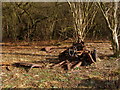
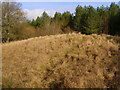
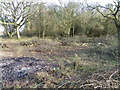
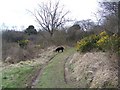
This long barrow is 38m long and 24 wide, with its higher and broader end oriented towards the southeast. Of its parallel side ditches only the western one is discernable. It is currently surrounded by trees, but at the time of its construction it would have been intervisible with the cluster of long barrows around the NE terminal of the Dorset Cursus on Martin Down.
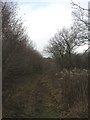
Access The barrow is just inside the public access woodland of Vernditch Chase to the north of the A354. Park at the Martin Down national nature reserve car park (SU037201), carefully cross over the A354 and the barrow is a five minute walk to the north, just to the right of the bridleway in a clearing.
You may be viewing yesterday's version of this page. To see the most up to date information please register for a free account.
 (PID:36409)")
Do not use the above information on other web sites or publications without permission of the contributor.
Nearby Images from Geograph Britain and Ireland:
©2008(licence)
©2008(licence)
©2010(licence)
©2012(licence)
©2008(licence)
The above images may not be of the site on this page, they are loaded from Geograph.
Please Submit an Image of this site or go out and take one for us!
Click here to see more info for this site
Nearby sites
Key: Red: member's photo, Blue: 3rd party photo, Yellow: other image, Green: no photo - please go there and take one, Grey: site destroyed
Download sites to:
KML (Google Earth)
GPX (GPS waypoints)
CSV (Garmin/Navman)
CSV (Excel)
To unlock full downloads you need to sign up as a Contributory Member. Otherwise downloads are limited to 50 sites.
Turn off the page maps and other distractions
Nearby sites listing. In the following links * = Image available
737m N 352° Vernditch Chase (North)* Long Barrow (SU03402113)
892m ESE 117° Martin Down Enclosure* Ancient Village or Settlement (SU043200)
984m SSE 156° Pentridge 3* Long Barrow (SU039195)
1.3km SSE 157° Pentridge Cursus Cursus (SU040192)
1.4km S 180° Bokerley Dyke* Misc. Earthwork (SU035190)
1.5km SSE 155° Pentridge 2* Long Barrow (SU04111907)
1.8km SSE 158° Pentridge 1* Long Barrow (SU04151877)
2.3km WSW 258° Bokerley Dyke Misc. Earthwork (SU01241990)
2.7km NW 326° Marleycombe Hill, earthworks* Misc. Earthwork (SU020226)
2.9km E 86° Longbarrow House* Long Barrow (SU064206)
3.0km SE 141° Blagdon Hill tumuli* Round Barrow(s) (SU054181)
3.2km SE 138° Grim's Ditch (Hampshire) Misc. Earthwork (SU05651802)
3.3km S 173° Penbury Knoll* Hillfort (SU039171)
3.5km SSW 209° Oakley Down Barrows* Barrow Cemetery (SU01821731)
3.6km SSW 196° Pentridge 4* Long Barrow (SU025169)
3.7km SE 129° Tidpit Common Down Long Barrow (SU064181)
3.8km SW 216° Wor Barrow* Long Barrow (SU01241729)
4.0km WSW 257° Mistlebury* Hillfort (ST99581948)
4.7km ENE 71° Furze Down Long Barrow (SU0791621895)
4.7km SSW 207° Bottlebush Down barrows* Barrow Cemetery (SU01381625)
4.7km SSW 202° Dorset Cursus* Cursus (SU01751600)
5.2km SSW 203° Pentridge Cursus Cursus (SU015156)
5.2km SSW 203° Gussage St Michael Cursus Cursus (SU015156)
5.4km WNW 282° South Down Ox Drove Tumuli* Round Barrow(s) (ST982215)
5.4km ESE 104° Knoll Down tumuli* Round Barrow(s) (SU088191)
View more nearby sites and additional images


 We would like to know more about this location. Please feel free to add a brief description and any relevant information in your own language.
 Wir möchten mehr über diese Stätte erfahren. Bitte zögern Sie nicht, eine kurze Beschreibung und relevante Informationen in Deutsch hinzuzufügen.
 Nous aimerions en savoir encore un peu sur les lieux. S'il vous plaît n'hesitez pas à ajouter une courte description et tous les renseignements pertinents dans votre propre langue.
 Quisieramos informarnos un poco más de las lugares. No dude en añadir una breve descripción y otros datos relevantes en su propio idioma.