


<< Our Photo Pages >> Great Tosson Enclosure - Ancient Village or Settlement in England in Northumberland
Submitted by SolarMegalith on Thursday, 17 January 2013 Page Views: 2029
Multi-periodSite Name: Great Tosson EnclosureCountry: England County: Northumberland Type: Ancient Village or Settlement
Nearest Village: Great Tosson
Map Ref: NU03130003
Latitude: 55.294374N Longitude: 1.952256W
Condition:
| 5 | Perfect |
| 4 | Almost Perfect |
| 3 | Reasonable but with some damage |
| 2 | Ruined but still recognisable as an ancient site |
| 1 | Pretty much destroyed, possibly visible as crop marks |
| 0 | No data. |
| -1 | Completely destroyed |
| 5 | Superb |
| 4 | Good |
| 3 | Ordinary |
| 2 | Not Good |
| 1 | Awful |
| 0 | No data. |
| 5 | Can be driven to, probably with disabled access |
| 4 | Short walk on a footpath |
| 3 | Requiring a bit more of a walk |
| 2 | A long walk |
| 1 | In the middle of nowhere, a nightmare to find |
| 0 | No data. |
| 5 | co-ordinates taken by GPS or official recorded co-ordinates |
| 4 | co-ordinates scaled from a detailed map |
| 3 | co-ordinates scaled from a bad map |
| 2 | co-ordinates of the nearest village |
| 1 | co-ordinates of the nearest town |
| 0 | no data |
Internal Links:
External Links:
I have visited· I would like to visit
SolarMegalith visited on 16th Jan 2013 - their rating: Cond: 3 Amb: 3 Access: 4
")
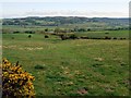
This rectangular enclosure of unsure age is located below the sharp slope to its north, on a natural terrace, a very poor location in terms of defense. There is no dating evidence from the site, but its shape suggests the possibility that it might be a Romano-British settlement rather then Iron Age site associated with Tosson Burgh hillfort.
The enclosure consists of a single bank and ditch, in its northern and eastern part there is also an outer bank which could be created within later episodes of re-cutting the ditch.
Pastscape lists it under no. 4623
You may be viewing yesterday's version of this page. To see the most up to date information please register for a free account.
")
")
")
")
Do not use the above information on other web sites or publications without permission of the contributor.
Nearby Images from Geograph Britain and Ireland:
©2008(licence)
©2010(licence)
©2020(licence)
©2008(licence)
©2010(licence)
The above images may not be of the site on this page, they are loaded from Geograph.
Please Submit an Image of this site or go out and take one for us!
Click here to see more info for this site
Nearby sites
Key: Red: member's photo, Blue: 3rd party photo, Yellow: other image, Green: no photo - please go there and take one, Grey: site destroyed
Download sites to:
KML (Google Earth)
GPX (GPS waypoints)
CSV (Garmin/Navman)
CSV (Excel)
To unlock full downloads you need to sign up as a Contributory Member. Otherwise downloads are limited to 50 sites.
Turn off the page maps and other distractions
Nearby sites listing. In the following links * = Image available
544m WSW 256° Great Tosson Cairn* Cairn (NZ026999)
912m WNW 300° Tosson Burgh* Hillfort (NU02340049)
1.5km SSW 209° Simonside Cairn 2* Cairn (NZ02409871)
1.6km SSW 196° Simonside Cairn 1* Cairn (NZ0271098520)
1.6km SSE 160° Dove Crag* Rock Outcrop (NZ0367898540)
1.6km SSE 158° Dove Crag Cairn* Cairn (NZ0372898523)
1.7km S 185° Old Stell Crag* Rock Outcrop (NZ0297498372)
1.7km WSW 239° Ravensheugh Cairn* Cairn (NZ0169099150)
1.9km W 272° Simonside Moor Rock Art (NU0120000100)
2.0km NNE 34° Westcliffe Modern Circle* Modern Stone Circle etc (NU0422301673)
2.0km SE 136° Spy Law Beacon Cairn* Cairn (NZ04529859)
2.0km ESE 119° West Lordenshaw (Birky Hill) N03 Rock Art (NZ0487999051)
2.0km NNE 33° Westcliffe House N01 Rock Art (NU0423501715)
2.0km NNE 32° Westcliffe House N02 Rock Art (NU0419801743)
2.0km NNE 33° Westcliffe House b Rock Art (NU0423001730)
2.0km NNE 33° Westcliffe House a* Rock Art (NU0423601730)
2.1km ESE 116° Birky Hill 1c* Rock Art (NZ0500799122)
2.1km ESE 116° Birky Hill 1b* Rock Art (NZ0500899118)
2.1km ESE 116° Birky Hill 1a* Rock Art (NZ0501099119)
2.1km SW 233° Ravenshaugh Main Stone* Natural Stone / Erratic / Other Natural Feature (NZ0144598783)
2.1km ESE 112° Birky Hill N01 Rock Art (NZ0509499241)
2.1km ESE 112° Birky Hill 1e* Rock Art (NZ0509799243)
2.1km ESE 112° Lordenshaw Horseshoe Rock* Rock Art (NZ0510099223)
2.1km ESE 113° Birky Hill N04 Rock Art (NZ0509899218)
2.1km ESE 113° Birky Hill N02 Rock Art (NZ0510099217)
View more nearby sites and additional images


 We would like to know more about this location. Please feel free to add a brief description and any relevant information in your own language.
 Wir möchten mehr über diese Stätte erfahren. Bitte zögern Sie nicht, eine kurze Beschreibung und relevante Informationen in Deutsch hinzuzufügen.
 Nous aimerions en savoir encore un peu sur les lieux. S'il vous plaît n'hesitez pas à ajouter une courte description et tous les renseignements pertinents dans votre propre langue.
 Quisieramos informarnos un poco más de las lugares. No dude en añadir una breve descripción y otros datos relevantes en su propio idioma.