


<< Our Photo Pages >> Whitepark Bay - Cairn in Ireland (Northern) in Co. Antrim
Submitted by ainsloch on Monday, 21 September 2015 Page Views: 2943
Neolithic and Bronze AgeSite Name: Whitepark BayCountry: Ireland (Northern) County: Co. Antrim Type: Cairn
Nearest Town: Ballycastle
Latitude: 55.232691N Longitude: 6.3935W
Condition:
| 5 | Perfect |
| 4 | Almost Perfect |
| 3 | Reasonable but with some damage |
| 2 | Ruined but still recognisable as an ancient site |
| 1 | Pretty much destroyed, possibly visible as crop marks |
| 0 | No data. |
| -1 | Completely destroyed |
| 5 | Superb |
| 4 | Good |
| 3 | Ordinary |
| 2 | Not Good |
| 1 | Awful |
| 0 | No data. |
| 5 | Can be driven to, probably with disabled access |
| 4 | Short walk on a footpath |
| 3 | Requiring a bit more of a walk |
| 2 | A long walk |
| 1 | In the middle of nowhere, a nightmare to find |
| 0 | No data. |
| 5 | co-ordinates taken by GPS or official recorded co-ordinates |
| 4 | co-ordinates scaled from a detailed map |
| 3 | co-ordinates scaled from a bad map |
| 2 | co-ordinates of the nearest village |
| 1 | co-ordinates of the nearest town |
| 0 | no data |
Internal Links:
External Links:
")
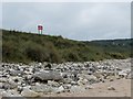
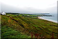
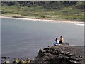
This area was a hotbed of activity in Neolithic times, largely due to the porcellanite axe factory on nearby Rathlin Island, and the flint nodules in the limestone cliffs along the coast here. There are also three small passage mounds nearby which overlook the bay, located to the south of the main coastal road.
The cairn can easily be reached from the beach.
You may be viewing yesterday's version of this page. To see the most up to date information please register for a free account.
")
")
Do not use the above information on other web sites or publications without permission of the contributor.
Nearby Images from Geograph Britain and Ireland:

©2007(licence)
©2013(licence)
©2014(licence)
©2014(licence)
©2012(licence)
The above images may not be of the site on this page, they are loaded from Geograph.
Please Submit an Image of this site or go out and take one for us!
Click here to see more info for this site
Nearby sites
Click here to view sites on an interactive map of the areaKey: Red: member's photo, Blue: 3rd party photo, Yellow: other image, Green: no photo - please go there and take one, Grey: site destroyed
Download sites to:
KML (Google Earth)
GPX (GPS waypoints)
CSV (Garmin/Navman)
CSV (Excel)
To unlock full downloads you need to sign up as a Contributory Member. Otherwise downloads are limited to 50 sites.
Turn off the page maps and other distractions
Nearby sites listing. In the following links * = Image available
450m SSE 150° Clegnagh* Passage Grave
1.5km ESE 101° Magheraboy* Passage Grave
5.4km S 172° Kilmahamogue Standing Stone* Standing Stone (Menhir) (NW212966)
5.9km SE 136° The Grey Stone (Moyarget)* Chambered Tomb (NW246974)
6.2km S 171° Druid's Altar (Mosside)* Cairn (NW213958)
8.6km SE 134° Kilcrue Cross* Ancient Cross (NW2658095587)
9.1km SE 133° Carneatley Standing Stone* Standing Stone (Menhir) (NW2700795317)
9.2km SE 139° Cloghanmurry Standing Stone* Standing Stone (Menhir) (NW2637094593)
9.4km W 260° Lissanduff Earthworks* Misc. Earthwork
9.7km SSW 199° Deffrick Castle* Souterrain (Fogou, Earth House) (NW170930)
10.2km SE 145° Monanclogh Standing Stone* Standing Stone (Menhir) (NW2612893283)
10.2km SW 228° Ballylough Crannog* Crannog (NW127957)
10.3km SSW 204° Drumlesk* Chambered Tomb (C983345)
10.6km WSW 238° Flower Hill* Standing Stone (Menhir) (NW114969)
11.1km SE 144° Knockans Rath / Souterrain* Souterrain (Fogou, Earth House) (NW267926)
11.5km SSE 148° Knockans Standing Stone* Standing Stone (Menhir) (NW2632591923)
11.6km S 176° Carnrig Fort* Artificial Mound (NW208904)
11.9km SSW 211° Decorated Stone, Derrykeighan* Sculptured Stone (NW139922)
12.0km SE 131° Knocklayd Cairn* Cairn
12.0km S 181° Carnfeogue Standing Stone* Standing Stone (Menhir) (NW197900)
12.0km ESE 107° Broughanlea Carved Cross* Ancient Cross (NW3211397785)
12.4km SE 145° Tullaghore Cross* Ancient Cross (NW2721091351)
12.9km ESE 106° Culfeightrin Stones* Standing Stones (D1477040765)
13.3km WSW 241° Beardiville Wedge Tomb* Wedge Tomb
13.4km SSE 155° Alcrossagh Fort* Hillfort (NW256894)
View more nearby sites and additional images


 We would like to know more about this location. Please feel free to add a brief description and any relevant information in your own language.
 Wir möchten mehr über diese Stätte erfahren. Bitte zögern Sie nicht, eine kurze Beschreibung und relevante Informationen in Deutsch hinzuzufügen.
 Nous aimerions en savoir encore un peu sur les lieux. S'il vous plaît n'hesitez pas à ajouter une courte description et tous les renseignements pertinents dans votre propre langue.
 Quisieramos informarnos un poco más de las lugares. No dude en añadir una breve descripción y otros datos relevantes en su propio idioma.