


<< Our Photo Pages >> Ranny Brook North Cist - Cist in England in Devon
Submitted by Anne T on Friday, 14 October 2016 Page Views: 1406
Neolithic and Bronze AgeSite Name: Ranny Brook North Cist Alternative Name: Grinsell Cornwood 11; Dixon 84; Butler Ranny Brook N 3 (Cist 3 V3 52.9)Country: England County: Devon Type: Cist
Nearest Town: Ivybridge Nearest Village: Cornwood
Map Ref: SX62156355
Latitude: 50.455543N Longitude: 3.943257W
Condition:
| 5 | Perfect |
| 4 | Almost Perfect |
| 3 | Reasonable but with some damage |
| 2 | Ruined but still recognisable as an ancient site |
| 1 | Pretty much destroyed, possibly visible as crop marks |
| 0 | No data. |
| -1 | Completely destroyed |
| 5 | Superb |
| 4 | Good |
| 3 | Ordinary |
| 2 | Not Good |
| 1 | Awful |
| 0 | No data. |
| 5 | Can be driven to, probably with disabled access |
| 4 | Short walk on a footpath |
| 3 | Requiring a bit more of a walk |
| 2 | A long walk |
| 1 | In the middle of nowhere, a nightmare to find |
| 0 | No data. |
| 5 | co-ordinates taken by GPS or official recorded co-ordinates |
| 4 | co-ordinates scaled from a detailed map |
| 3 | co-ordinates scaled from a bad map |
| 2 | co-ordinates of the nearest village |
| 1 | co-ordinates of the nearest town |
| 0 | no data |
Be the first person to rate this site - see the 'Contribute!' box in the right hand menu.
Internal Links:
External Links:
")
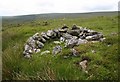
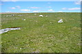
This site, Ranny Brook (North of) Cist, is featured on the Prehistoric Dartmoor Walks website. Their notes tell us: "the northern end-stone and the western side-stone survive, whilst smaller stones may represent the other sides."
Further information on this cist can be found on the Pastscape website, see Monument Number 442249, which says this cist lies on the eastern edge of a large stone hut circle settlement and is "about 33 yards south east from the south east angle of the pound, with hut circles and 250 yards north of the Ranny Brook ..... the eastern side and the southern end still stand, while a partially sunken stone may be the displaced western side. The side-stone stands 23 inches above ground level, and is 2ft 6 ins in length .... situated on a south facing slope at 350m OD."
The cairn is also recorded as MDV4272 (Cist 430 metres east-south-east of Yealm Steps), which adds that "there is no trace of a cairn mound, but the old ground surface beneath this may survive as a buried feature." The cist is also scheduled as Historic England List Entry No. 1008646 (Cist 430m ESE of Yealm Steps).
You may be viewing yesterday's version of this page. To see the most up to date information please register for a free account.
Do not use the above information on other web sites or publications without permission of the contributor.
Nearby Images from Geograph Britain and Ireland:
©2009(licence)
©2012(licence)
©2012(licence)
©2009(licence)
©2012(licence)
The above images may not be of the site on this page, they are loaded from Geograph.
Please Submit an Image of this site or go out and take one for us!
Click here to see more info for this site
Nearby sites
Key: Red: member's photo, Blue: 3rd party photo, Yellow: other image, Green: no photo - please go there and take one, Grey: site destroyed
Download sites to:
KML (Google Earth)
GPX (GPS waypoints)
CSV (Garmin/Navman)
CSV (Excel)
To unlock full downloads you need to sign up as a Contributory Member. Otherwise downloads are limited to 50 sites.
Turn off the page maps and other distractions
Nearby sites listing. In the following links * = Image available
156m WSW 242° Yealm Steps* Ancient Village or Settlement (SX62016348)
178m E 88° Ranny Brook Enclosure Ancient Village or Settlement (SX6232963551)
459m E 90° Ranny Brookhead Cist* Cist (SX62616354)
952m SSE 160° Harrowthorn* Cairn (SX6244662645)
980m SW 218° Dendles Waste* Cairn (SX61536279)
1.2km ESE 104° Stalldown North* Cairn (SX63276323)
1.4km SSE 149° Stalldown West* Cist (SX6284462309)
1.4km ENE 78° Blatchford Brook Foot Settlement* Ancient Village or Settlement (SX63566380)
1.5km SE 134° Stalldown Encircled Cairn* Cairn (SX6320862489)
1.5km SE 133° Stalldon Row* Stone Row / Alignment (SX63236248)
1.6km SE 133° Stalldown Stone Row Cairn E* Cairn (SX63286245)
1.6km SE 135° Stalldown Cairn Circle* Stone Circle (SX63246241)
1.6km NE 55° Stall Moor circle* Stone Circle (SX6351764442)
1.6km NE 55° Upper Erme Row* Stone Row / Alignment (SX63526447)
1.7km E 87° Dry Lake North Settlement* Ancient Village or Settlement (SX639636)
1.9km SE 131° Stalldown Ring Cairn Circle* Ring Cairn (SX63526230)
1.9km WSW 241° High-house Waste Ancient Village or Settlement (SX60506270)
2.0km WSW 249° Penn Moor Reave East Misc. Earthwork (SX60306289)
2.0km NE 43° Upper Erme Cairns* Cairn (SX6352264958)
2.0km SE 129° Hillson's House* Cairn (SX63666228)
2.0km SE 146° Stalldown Stone Row Cairn S* Cairn (SX63226186)
2.1km SSE 149° Stalldown Southern Terminal Cairn Circle* Cairn (SX6317661737)
2.3km WSW 250° Penn Moor Reave West Misc. Earthwork (SX59956282)
2.3km WSW 253° Penn Beacon Cairn* Cairn (SX59916292)
2.3km W 275° Shell Top Cairn Circle Ring Cairn (SX5983063830)
View more nearby sites and additional images


 We would like to know more about this location. Please feel free to add a brief description and any relevant information in your own language.
 Wir möchten mehr über diese Stätte erfahren. Bitte zögern Sie nicht, eine kurze Beschreibung und relevante Informationen in Deutsch hinzuzufügen.
 Nous aimerions en savoir encore un peu sur les lieux. S'il vous plaît n'hesitez pas à ajouter une courte description et tous les renseignements pertinents dans votre propre langue.
 Quisieramos informarnos un poco más de las lugares. No dude en añadir una breve descripción y otros datos relevantes en su propio idioma.