


<< Our Photo Pages >> Castle Hill (Ancrum) - Hillfort in Scotland in Scottish Borders
Submitted by Anne T on Wednesday, 04 October 2017 Page Views: 2797
Iron Age and Later PrehistorySite Name: Castle Hill (Ancrum)Country: Scotland County: Scottish Borders Type: Hillfort
Nearest Town: Jedburgh Nearest Village: Ancrum
Map Ref: NT6239424909
Latitude: 55.516478N Longitude: 2.5971W
Condition:
| 5 | Perfect |
| 4 | Almost Perfect |
| 3 | Reasonable but with some damage |
| 2 | Ruined but still recognisable as an ancient site |
| 1 | Pretty much destroyed, possibly visible as crop marks |
| 0 | No data. |
| -1 | Completely destroyed |
| 5 | Superb |
| 4 | Good |
| 3 | Ordinary |
| 2 | Not Good |
| 1 | Awful |
| 0 | No data. |
| 5 | Can be driven to, probably with disabled access |
| 4 | Short walk on a footpath |
| 3 | Requiring a bit more of a walk |
| 2 | A long walk |
| 1 | In the middle of nowhere, a nightmare to find |
| 0 | No data. |
| 5 | co-ordinates taken by GPS or official recorded co-ordinates |
| 4 | co-ordinates scaled from a detailed map |
| 3 | co-ordinates scaled from a bad map |
| 2 | co-ordinates of the nearest village |
| 1 | co-ordinates of the nearest town |
| 0 | no data |
Internal Links:
External Links:
I have visited· I would like to visit
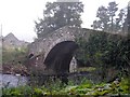
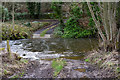
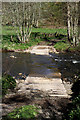
Anne T saw from a distance on 20th Sep 2017 - their rating: Cond: 2 Amb: 4 Access: 4 Castle Hill Hillfort, Ancrum, Scottish Borders: It was getting late in the evening, with dusk coming on, so sadly there wasn’t time to drive back into Ancrum and back round the other side to clamber up to this enticing hill fort, which is visible from Ancrum Old Church and can also be clearly seen on UK Grid Reference Finder. We did try walking across the pack horse bridge across Ale Water, letting ourselves out of the wrought iron gates at the eastern side, but the cottage and adjacent barns we’d have needed to walk through were a building site and were cordoned off.
Decided to leave this for another day, and drove back past the market cross to photograph that before heading off to Armadale.
 (PID:171713)")
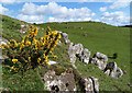
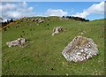
This hillfort can be seen from Ancrum Old Church, rising high above the eastern side of the churchyard, with a loop of Ale Water protecting its western side.
Recorded as Canmore ID 57086, it is described as a 'Dark Age Fort' which occupies the whole of the flat-topped western end of a narrow ridge. The hillfort "comprises three contiguous enclosures, lying roughly E and W; the westernmost enclosure (A) is oval on plan while the other two (B and C) are subrectangular. Enclosure A measures 200ft from E to W by 165ft from N to S within a boulder-faced rubble wall which, except on the E side, is from 7ft 6in to 10ft thick. Many of the foundation-stones of this wall are still in situ, including a number of massive grounders up to 4ft 6in long such as are found loose on the surface of the ridge or may be easily quarried from the outcrops on the adjacent knoll."
At the time of our visit, the path to the steeper, western side of the hillfort from the church (over the old bridge) was closed due to building works. From Ancrum village, a small road and footpath gives access onto the gentler, eastern flank of the hill.
You may be viewing yesterday's version of this page. To see the most up to date information please register for a free account.
 (PID:182600)")
 (PID:171712)")
Do not use the above information on other web sites or publications without permission of the contributor.
Nearby Images from Geograph Britain and Ireland:
©2012(licence)
©2012(licence)
©2008(licence)
©2020(licence)
©2012(licence)
The above images may not be of the site on this page, they are loaded from Geograph.
Please Submit an Image of this site or go out and take one for us!
Click here to see more info for this site
Nearby sites
Key: Red: member's photo, Blue: 3rd party photo, Yellow: other image, Green: no photo - please go there and take one, Grey: site destroyed
Download sites to:
KML (Google Earth)
GPX (GPS waypoints)
CSV (Garmin/Navman)
CSV (Excel)
To unlock full downloads you need to sign up as a Contributory Member. Otherwise downloads are limited to 50 sites.
Turn off the page maps and other distractions
Nearby sites listing. In the following links * = Image available
244m W 264° Ancrum Old Church* Sculptured Stone (NT6215024885)
1.5km NE 44° Harrietsfield Standing Stone (Menhir) (NT63442599)
1.8km ESE 119° Harestanes (Ancrum) Stone Circle (NT640240)
1.9km ESE 118° Harestanes (Ancrum) Stone Circle (NT641240)
2.2km E 83° Woodside (Crailing) Standing Stone (Menhir) (NT64552517)
5.0km E 80° Nisbet 2 Sculptured Stone (NT67322572)
5.2km SSE 149° Jedburgh Ancient Christian Stones* Ancient Cross (NT65052038)
5.3km SSE 149° Jedburgh Rock Art Rock Art (NT651204)
5.4km NNW 348° Maxton Burgh (St Boswells)* Ancient Cross (NT61333020)
5.6km NE 50° Fairnington Stone Circle (NT667285)
5.8km NNW 342° Hier Well (Benrig)* Holy Well or Sacred Spring (NT60703042)
5.9km NNW 342° St Boswell's Old Church* Ancient Cross (NT6063730533)
6.2km NNW 343° Crystal Well (Benrig)* Holy Well or Sacred Spring (NT6064030847)
6.4km E 92° Crailing Cross* Ancient Cross (NT6879724676)
7.0km N 353° Mertoun Kirk (St Boswells)* Sculptured Stone (NT6155231821)
7.3km SSW 203° Fast Castle (Bedrule)* Misc. Earthwork (NT59531822)
7.4km SSW 199° Bedrule Parish Church* Sculptured Stone (NT5992217925)
7.5km SSW 202° Bedrule Sculptured Stone (NT59501793)
8.2km NNW 339° Font Stone (Dryburgh)* Ancient Cross (NT59543258)
8.2km NE 37° The Law (Scottish Borders) Artificial Mound (NT6735831447)
8.4km S 170° Gilliestongues Promontory Fort / Cliff Castle (NT63721659)
10.0km ENE 78° Haughhead Kip (Eckford)* Sculptured Stone (NT72212683)
10.3km SSW 205° Rubers Law* Hillfort (NT58031557)
10.5km NW 325° Rhymer's Stone (Melrose)* Marker Stone (NT5651833592)
10.5km NW 318° Eildon Hill North* Hillfort (NT55453280)
View more nearby sites and additional images


 We would like to know more about this location. Please feel free to add a brief description and any relevant information in your own language.
 Wir möchten mehr über diese Stätte erfahren. Bitte zögern Sie nicht, eine kurze Beschreibung und relevante Informationen in Deutsch hinzuzufügen.
 Nous aimerions en savoir encore un peu sur les lieux. S'il vous plaît n'hesitez pas à ajouter une courte description et tous les renseignements pertinents dans votre propre langue.
 Quisieramos informarnos un poco más de las lugares. No dude en añadir una breve descripción y otros datos relevantes en su propio idioma.