


<< Our Photo Pages >> Gorseddau Standing Stone - Standing Stone (Menhir) in Wales in Gwynedd
Submitted by TAlanJones on Monday, 25 March 2024 Page Views: 45
Neolithic and Bronze AgeSite Name: Gorseddau Standing Stone Alternative Name: Standing Stone Cwm YstradllynCountry: Wales County: Gwynedd Type: Standing Stone (Menhir)
Nearest Town: Porthmadog Nearest Village: Dolbenmaen
Map Ref: SH5698245533
Latitude: 52.987988N Longitude: 4.132016W
Condition:
| 5 | Perfect |
| 4 | Almost Perfect |
| 3 | Reasonable but with some damage |
| 2 | Ruined but still recognisable as an ancient site |
| 1 | Pretty much destroyed, possibly visible as crop marks |
| 0 | No data. |
| -1 | Completely destroyed |
| 5 | Superb |
| 4 | Good |
| 3 | Ordinary |
| 2 | Not Good |
| 1 | Awful |
| 0 | No data. |
| 5 | Can be driven to, probably with disabled access |
| 4 | Short walk on a footpath |
| 3 | Requiring a bit more of a walk |
| 2 | A long walk |
| 1 | In the middle of nowhere, a nightmare to find |
| 0 | No data. |
| 5 | co-ordinates taken by GPS or official recorded co-ordinates |
| 4 | co-ordinates scaled from a detailed map |
| 3 | co-ordinates scaled from a bad map |
| 2 | co-ordinates of the nearest village |
| 1 | co-ordinates of the nearest town |
| 0 | no data |
Internal Links:
External Links:
")
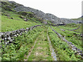
Situated on high ground to the NE of Llyn Ystradllyn this little stone lies 5m from a modern dry stone boundary wall. The stone stands at 0.5m by 0.35m wide and 0.3m at its thickest, and it is firmly rooted. Not much is known about it. The abandoned Gorseddau Quarry is a little further up the valley and there may be some connection there? I spoke with the local farmer, who was sheep gathering and he knew of it but had no awareness of its history.
Coflein has recorded the stone as NPRN 287853.
You may be viewing yesterday's version of this page. To see the most up to date information please register for a free account.
")
")
")
Do not use the above information on other web sites or publications without permission of the contributor.
Nearby Images from Geograph Britain and Ireland:
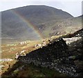
©2008(licence)
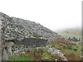
©2006(licence)
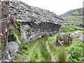
©2019(licence)
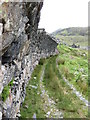
©2019(licence)
©2019(licence)
The above images may not be of the site on this page, they are loaded from Geograph.
Please Submit an Image of this site or go out and take one for us!
Click here to see more info for this site
Nearby sites
Key: Red: member's photo, Blue: 3rd party photo, Yellow: other image, Green: no photo - please go there and take one, Grey: site destroyed
Download sites to:
KML (Google Earth)
GPX (GPS waypoints)
CSV (Garmin/Navman)
CSV (Excel)
To unlock full downloads you need to sign up as a Contributory Member. Otherwise downloads are limited to 50 sites.
Turn off the page maps and other distractions
Nearby sites listing. In the following links * = Image available
225m SW 232° Settlement North of Ffridd Isaf* Ancient Village or Settlement (SH568454)
229m WNW 296° Ffridd Uchaf Standing Stone* Standing Stone (Menhir) (SH5677945640)
244m S 187° Gorseddau Hut Circle 1* Ancient Village or Settlement (SH5694445292)
436m WSW 254° Ancient field Systems East of Plas Llyn* Ancient Village or Settlement (SH5655845428)
481m W 267° Cwm Ystradllyn Cairn Cemetery* Barrow Cemetery (SH5650045525)
482m W 264° Hut Circle North of Ffridd Isaf* Ancient Village or Settlement (SH565455)
484m W 270° Cwm Ystradllyn Stone Alignment* Stone Row / Alignment (SH5649745545)
487m W 270° Cwm Ystradllyn possible Cairn with Capstone* Cairn (SH5649445544)
487m SSE 163° Gorseddau Hut Circle 3* Ancient Village or Settlement (SH5711045063)
506m SW 227° Ffridd Isaf Standing Stone Standing Stone (Menhir) (SH566452)
507m WSW 250° Hut Circle East of Plas Llyn* Ancient Village or Settlement (SH5650045370)
518m SSE 158° Gorseddau Hut Circle 2* Ancient Village or Settlement (SH5716645048)
579m SSW 212° Ffridd Isaf* Ring Cairn (SH5666245049)
620m SSE 148° Bwlch Cwmystradllyn hut circles* Ancient Village or Settlement (SH573450)
904m SSW 207° Llyn Ystradllyn Hut Circle* Ancient Village or Settlement (SH5654744739)
965m SSE 165° Ffridd Fawr Hut Circles* Ancient Village or Settlement (SH5721244595)
1.0km SE 130° Bwlch Cwm Ystradllyn Settlement* Ancient Village or Settlement (SH5773044860)
1.1km SW 225° Hut Circle Settlement East of Cefn Bifor* Ancient Village or Settlement (SH562448)
1.2km W 264° Plas Llyn Mound* Artificial Mound (SH5578045440)
1.2km S 184° Clogwyn y Garth Hut Circle 2* Ancient Village or Settlement (SH5685844295)
1.2km SE 128° Llyn Oer Ddwr Hut Circles* Ancient Village or Settlement (SH5795044740)
1.3km SE 130° Llyn Oer Ddwr Enclosure* Ancient Village or Settlement (SH5792744697)
1.3km WSW 258° Hut Circle Settlement West of Treforys deserted quarry village* Ancient Village or Settlement (SH557453)
1.3km S 182° Clogwyn y Garth Hut Circle 1* Ancient Village or Settlement (SH5689144221)
1.3km W 262° Plas Llyn Settlement* Ancient Village or Settlement (SH5566945399)
View more nearby sites and additional images


 We would like to know more about this location. Please feel free to add a brief description and any relevant information in your own language.
 Wir möchten mehr über diese Stätte erfahren. Bitte zögern Sie nicht, eine kurze Beschreibung und relevante Informationen in Deutsch hinzuzufügen.
 Nous aimerions en savoir encore un peu sur les lieux. S'il vous plaît n'hesitez pas à ajouter une courte description et tous les renseignements pertinents dans votre propre langue.
 Quisieramos informarnos un poco más de las lugares. No dude en añadir una breve descripción y otros datos relevantes en su propio idioma.