


Unseen Sahara
A rare aerial look at Libya's remote Fezzan region, where ancient societies thrived and collapsed as the rains came and went
An ancient wind is coming up from a place called deep time. The Sahara strikes us as an eternal inferno of dunes and blue sky. We are dazzled by its vistas but fail to notice it as one of the great record-keeping places on Earth. The past survives here and speaks from the sand, rock, heat, and dry winds. It whispers to us about a history of repeated jolts of climate change and of the advance and retreat of humanity.
David Mattingly heads a team of scholars on the Desert Migrations Project, whose work takes us to prehistory. They are time travelers who use four-wheel-drive vehicles to navigate the Sahara looking for traces of our forebears. With special tires deflated to provide extra traction, they conquer dunes up to a hundred feet high. They have opened up a whole new way to see this desert.
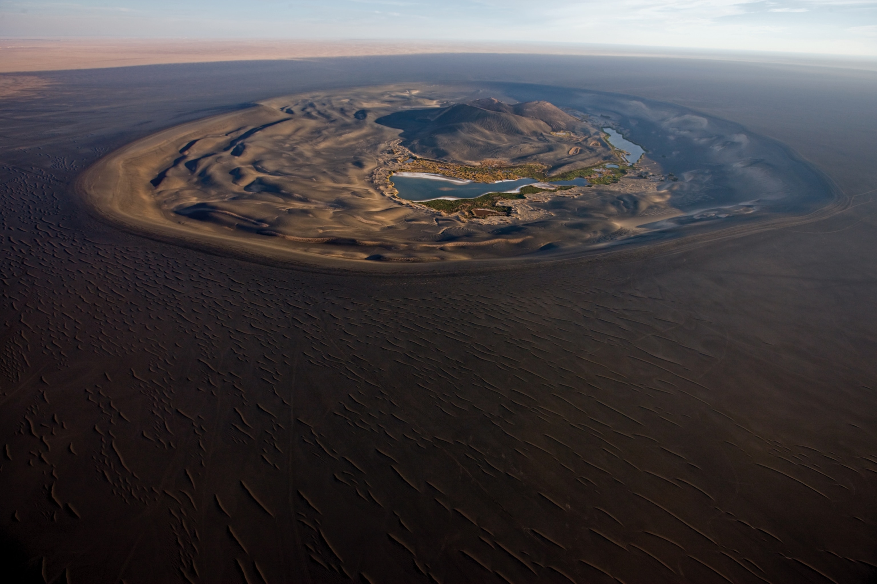
In the southwest part of Libya, a region called Fezzan is the beating heart of the Sahara, an inaccessible place full of sand seas, wadis, mountains, plateaus, oases, and mystery. Between 500 B.C. and A.D. 500 an estimated 100,000 people farmed and thrived here, in an area that typically receives less than an inch of rain a year and many years none at all.
"That," Mattingly notes, "is an awful lot of people in the hyperarid landscape of the central Sahara."
An archaeologist at the University of Leicester, he's become a slave to the desert: "I've been working in Libya for 30 years, and from the start I was wowed by the landscapes." Many others have known this fate. They become addicted to brilliant light and uncluttered horizons. Where most see a wasteland, others find clarity.
Hugh Clapperton, a Scottish explorer, plunges into the desert of southwestern Libya between 1822 and 1825. He is the point man of an empire, the face of steam power, spinning jennies, and the British fleet. On November 7, 1824, he is crossing the dry ground when he comes upon a female slave left "to perish on the road today, her head was terribly swelled & unable to walk & insensible." Clapperton finds one of the master's servants huddled by the woman, "waiting by her until she died, not to bury her but to bring away the few rags she had on."
She cannot ride a camel; she is too weak to hold on. He thinks if he lingers, he will die too.
The wind is cold, he notes.
He rides on.
This is the Sahara of dread. A waterless sea of sand and stone, where scorpions infest, vipers slither, and the sun has no mercy. Libya is big—a slab of sun the size of Italy, France, Spain, and Germany—and almost all of its six million people live huddled on the Mediterranean coast. To truly understand the region, we must turn our backs on the sea and look south. Ninety-five percent of Libya is desert, 20 percent is dunes, and not a single perennial river runs through it. The Libyan Sahara holds the world's heat record (136°F) and can chill the bones on a winter night.
Ibrahim al-Koni, Libya's leading novelist, was raised as a Tuareg in the Fezzan. In his book The Bleeding of the Stone, he quotes a Sufi song:
The desert is a true treasure
for him who seeks refuge
from men and the evil of men.


In it is contentment,
in it is death and all you seek.
The Fezzan reveals thousands of years of life struggling against change, of humans adapting to a hostile environment. It is a time machine where the past slaps us in the face, and if we linger, things happen to our safe ideas.
We moderns have grudgingly accepted that the past is a record of shifts in climate, great migrations, the rise and fall of nations, yet we act as if our present is the final chapter. But in the Sahara a very long tale confronts any visitor, a reminder that this current chapter is thin and fragile.
Mattingly's investigations bring him to the Ubari Sand Sea, where there are, improbably, many tiny, gem-colored lakes—some purple, some orange from minerals and algae—that are the dried-up reminders of a previous time when groundwater lay closer to the surface than it does today. It's hard to imagine, but a lake the size of England, Lake Megafezzan, gleamed here about 200,000 years ago, when rainfall was abundant, and ancient channels testify that rivers ran in the center of the desert.
Climate change has been like an on-off switch in the Sahara. In dry times the lakes dwindled and the plants declined to niches. Then, when moister times returned, the lakes filled and parts of the Sahara were transformed to savanna. Human communities have pulsed here like the explosion of plants after a rare rain. When moist eras visited, they thrived. When the dry times returned, they shrank or collapsed.
How does one locate waterways of long ago? From way up high. Using radar images taken from space, Migrations Project team members Kevin White and Nick Drake have been able to map the location of mineral residues from ancient lakes and springs, then steer their Land Rovers to those spots, where paleoanthropologists Robert Foley and Marta Mirazón Lahr discovered stone tools, arrowheads, fireplaces, graves, and other clues to human occupation.
The earliest modern humans in the region were hunters and gatherers who lived in a savanna landscape about 130,000 years ago. Those people cleared out when the rains tapered off about 70,000 years ago, but then the rains returned and people moved in again. This back-and-forth migration is called the Saharan pump, a movement of people in and out of northern Africa as the climate shifted. Scratched on the desert's rocks are the memories of a wetter Sahara, when water-dependent creatures such as lions, elephants, and rhinoceroses lived here.
A funny thing happened when the most recent wet phase ended. About 5,000 years ago the rains stopped once more, the lakes disappeared, and the desert took hold. Yet this time the people stayed. Rock art suggests they had already made the transition from hunting to raising livestock. Next came the rise of a society that would begin building towns and make the transition to agriculture: the Garamantian civilization.
The Garamantes flourished here in a climate much like that of the Sahara today. Many scholars assumed they were desert nomads, but excavations at their capital city, Garama (near modern-day Jarmah), and land surveys by Mattingly's team have shown they were sedentary people living off oasis agriculture. They constructed a sophisticated irrigation system that allowed them to grow wheat, barley, sorghum, date palms, and olives. Underground canals—called foggaras—tapped into groundwater and directed it to fields without loss to evaporation. Six hundred miles of these canals can still be detected. The system worked well for hundreds of years. And then the "fossil" water, stored up in wet times, started to give out, and the civilization collapsed.
The Sahara seems like a barrier at first glance, severing Africa into two pieces. But for the humans who have lived in Libya for thousands of years, it has been a corridor. Gold and ivory and slaves came north from sub-Saharan Africa; olive oil, wine, glass, and other goods from the Mediterranean flowed south. This trade creates a lasting image in our minds: the caravan wending its way through huge dunes.
The Saharan corridor may even have been one of the pathways our ancestors followed when they left the eastern part of the continent to populate the rest of the world. Scholars have long assumed that early humans expanded beyond sub-Saharan Africa into Eurasia by migrating either along the Nile River and across the Sinai or across the Red Sea. Now another notion is being explored: that the Fezzan may have been part of a long migratory corridor leading some modern humans to the shores of the Mediterranean and from there across the Sinai. Perhaps, through this sea of sand, our ancestors trekked from the Great Rift Valley and into our lives.
Mattingly says he likes archaeology because "it has lessons for today." Fifteen hundred years after the fall of the Garamantes, the Libyan government is now building the Great Man-Made River, a series of huge aqueducts to mine ancient underground water reserves below the Sahara and use them to make the desert bloom. The water being pumped was deposited tens of thousands of years ago, in much wetter times. Already the water table is declining because of the pumping. The project has an estimated life span of only 50 to 100 years, a blink of the eye in this region.
Clearly the last chapter of the Fezzan is yet to be written.
You May Also Like


Go Further
Animals
- This fungus turns cicadas into zombies who procreate—then dieThis fungus turns cicadas into zombies who procreate—then die
- How can we protect grizzlies from their biggest threat—trains?How can we protect grizzlies from their biggest threat—trains?
- This ‘saber-toothed’ salmon wasn’t quite what we thoughtThis ‘saber-toothed’ salmon wasn’t quite what we thought
- Why this rhino-zebra friendship makes perfect senseWhy this rhino-zebra friendship makes perfect sense
Environment
- Your favorite foods may not taste the same in the future. Here's why.Your favorite foods may not taste the same in the future. Here's why.
- Are the Great Lakes the key to solving America’s emissions conundrum?Are the Great Lakes the key to solving America’s emissions conundrum?
- The world’s historic sites face climate change. Can Petra lead the way?The world’s historic sites face climate change. Can Petra lead the way?
- This pristine piece of the Amazon shows nature’s resilienceThis pristine piece of the Amazon shows nature’s resilience
- 30 years of climate change transformed into haunting music30 years of climate change transformed into haunting music
History & Culture
- Hawaii's Lei Day is about so much more than flowersHawaii's Lei Day is about so much more than flowers
- When treasure hunters find artifacts, who gets to keep them?When treasure hunters find artifacts, who gets to keep them?
- Meet the original members of the tortured poets departmentMeet the original members of the tortured poets department
- When America's first ladies brought séances to the White HouseWhen America's first ladies brought séances to the White House
Science
- Should you be concerned about bird flu in your milk?Should you be concerned about bird flu in your milk?
- Here's how astronomers found one of the rarest phenomenons in spaceHere's how astronomers found one of the rarest phenomenons in space
- Not an extrovert or introvert? There’s a word for that.Not an extrovert or introvert? There’s a word for that.
Travel
- Are Italy's 'problem bears' a danger to travellers?Are Italy's 'problem bears' a danger to travellers?
- How to navigate Nantes’ arts and culture scene
- Paid Content
How to navigate Nantes’ arts and culture scene - This striking city is home to some of Spain's most stylish hotelsThis striking city is home to some of Spain's most stylish hotels
- Photo story: a water-borne adventure into fragile AntarcticaPhoto story: a water-borne adventure into fragile Antarctica
