|
||

|

|
|

|
The Quest for the Independent Nation of Pashtunistan.
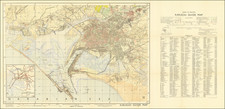
Rare and important Pashto-language map of the proposed political boundaries of Pashtunistan, an ethnic nation on the Pakistani-Afghani border with roots in the independence movements of the late 1940s.
The map presents a complex geopolitical statement that can be understood as Afghani pro-Pashtun and anti-Pakistan propaganda from the early 1950s, when Afghani Pashtuns held important government positions. The boundaries of Pashtunistan proposed on the map do not impinge on the territorial integrity of Afghanistan; rather, it takes its territory, in full, from Pakistan. This is despite the fact that a significant portion of southeastern Afghanistan is dominantly Pashtun. As such, it fits in with the criticisms of Pashtun Afghani Prime Minister Mohammad Zahir Shah's (in office 1953-1963) pro-Pashtun reunification efforts: that they were simply a means to split Pakistan, enlarge Afghanistan by absorbing this new homeland, and create a Pashtun ethnic majority in a country famously devoid of ethnic majorities.
Description of the Map
The map shows the territorial extent of the proposed ethnic state of Pashtunistan, extending northwards to the Hindu Corridor and the border with the Wakhan Corridor. The limits of different subregions are shown. Some features of physical geography are indicated.
Above and to the left of the map is a representation of the flag of Pashtunistan, showing a sun rising over a mountain landscape with Pastho writing. A legend appears in the lower left. An inset map shows the greater region in English. Pashtunistan and Kashmir are shown separated from Pakistan, suggesting a possible dissection of that nation.
The State of Pashtunistan in the 1950s
The Pashtun ethnicity draws its culture from a pre-Islamic tradition, in contrast to many of the younger ethnicities in the area. This has led to a strong sense of self for the Pashtun people for many centuries, but the push for an ethnic Pashtun nation tied to Afghanistan commenced during the post-World War II period in India. During the 1940s, the Afghan government sought to gain concessions from the British government that it would have a say in the future of Pashtun-dominated portions of Pakistan, which was, for the most part, rejected.
Following the independence of Pakistan in 1947, the rise of Pashtun nationalism in Afghanistan then started to dominate the conversation. As Afghanistan's pluralistic ethnicity, some parties sought to draw Pashtun-dominated parts of Pakistan into Afghanistan. This irredentist claim, however, angered non-Pashtun Afghanis, who saw a potential Pashtun majority in Afghanistan as a threat. As such, some Afghani Pashtuns switched their support to an independent Pashtunistan, which was less of a threat.
The push for an independent Pashtunistan decreased in the later 1950s and the 1960s when the Pakistani government made a conscious effort to try and further integrate Pashtuns, partly through promotion in positions of power. Ayub Khan, President of Pakistan from 1958 to 1969, was ethnically Pashtun.
Afghani Patronage of Pashto
The map was almost certainly created in Afghanistan during the reign of Mohammad Zahir Shah, following the assassination of his father in 1933. Shah was 19 when he succeeded to the throne, which he held from 1933 to 1973. At the time the map was created, the ruling party was attempting to foster the growth and spread of Pashto, officially specified as the key language for government. Persian-language newspapers were required to publish pages in Pashto. Official patronage of Pashto was systematically attempted from 1953 to 1963, when Mohammed Daoud Khan (a prince and cousin of the king) was prime minister. According to Louis Dupree, an American anthropologist resident in Kabul:
Some non-Pashto-speaking high-ranking officials found it necessary to have clerks translate their Farsi communications into Pashto for transmission to another office. The recipient, often a non-Pashto speaker as well, handed the report to an assistant for translation back into Farsi. The scheme collapsed in a welter of translation and retranslation.
The map defines national borders, regional subdivisions, and the country’s limited infrastructure. And map historians have long pointed out that defining a nation cartographically can have an enormous influence and impact on actual reality. Consequently, this map was not just a nationalist project but a means for Afghans to familiarize themselves with their own country. Despite enormous regional influence at the time, there is not a single label in Farsi, English or Russian. This was an Afghan map for Afghan people.
Rarity
Pashto-language maps are rare. This is only the second time we have ever had one, and they are extremely poorly represented on the wider antiquarian market.
![[ Pakistan and Afghanistan ] Nona Asie Tabula [Ninth Map of Asia]](https://storage.googleapis.com/raremaps/img/small/101345.jpg)
![Tabula Asiae IX [Northern India & Pakistan]](https://storage.googleapis.com/raremaps/img/small/77557.jpg)