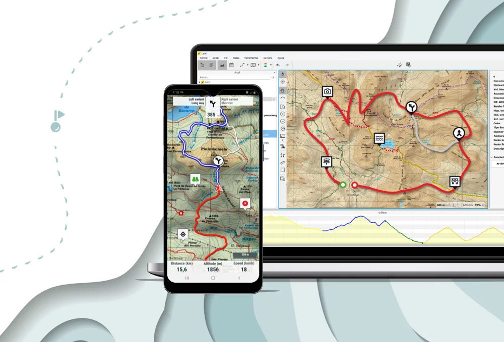
Terra includes the complete TwoNav Experience
Perfectly planned routes, high-quality maps, and cloud storage
 Secure Payment
 Free shipping on orders over €60 (UE)
 Financing on orders over € 50
 Hassle-free returns Secure Payment Free shipping on orders over €60 (UE) Hassle-free returns
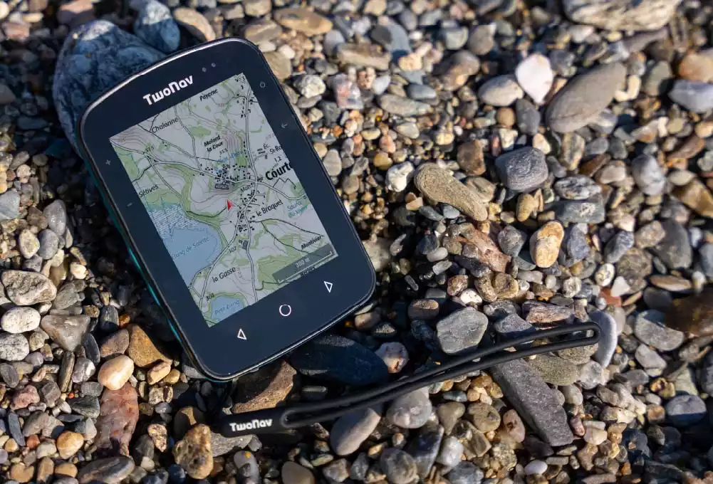
Anticipate what lies ahead without straining your eyes, with its large screen you will see beyond your current position, explore the area around you from the screen

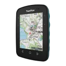
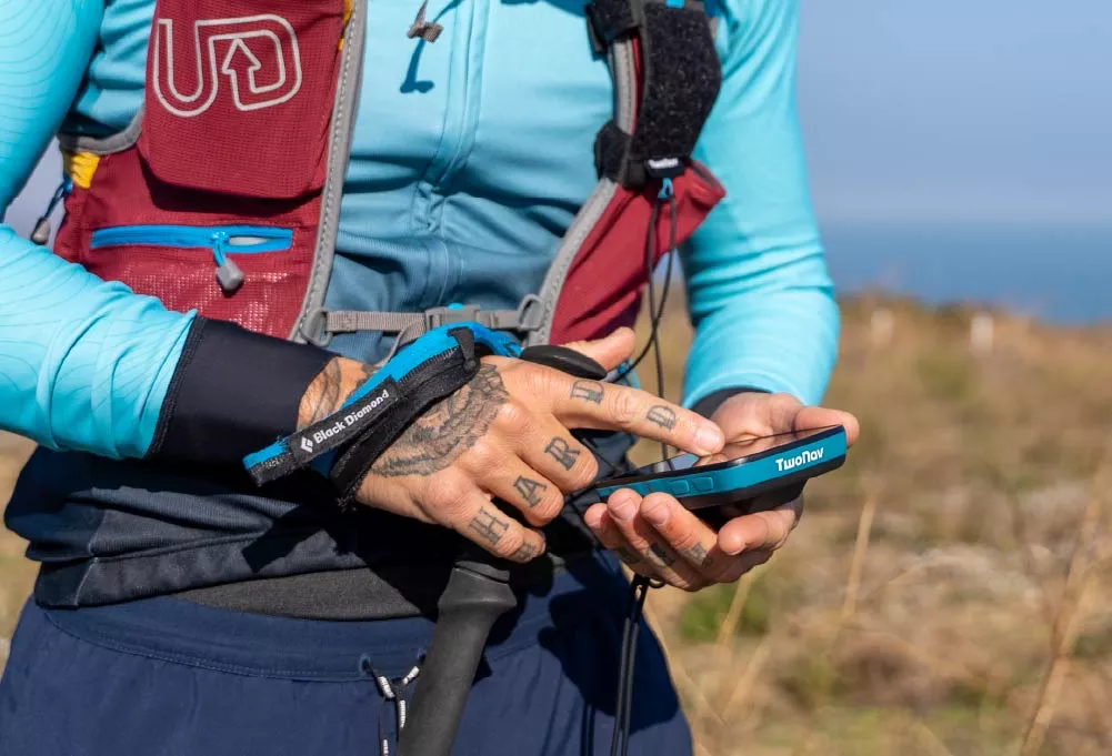
Terra is a very light and portable GPS that you can use comfortably in one hand during your hiking routes or fix it on your bike, always carry it with you and use it on unknown terrain or unmarked paths

The intense sunlight during your outings will no longer be a problem, with Terra's Gorilla Glass powerful screen you will avoid reflections and lack of visibility
Terra is much more than a GPS, it is your ally in the mountains, with it you can load countless routes and even create them yourself point by point directly on the GPS screen. If a route does not convince you, adapt it to you by modifying its path, create bifurcations and variants. Remember to take with you several maps of the area you are going to visit, with Terra you will work with several maps at the same time, so you will obtain greater detail of all the unmarked paths and shortcuts. Move around the map and you will find other points of interest close to your position, take the opportunity to visit them. Boost your outings with a more complete experience!
Terra is much more than a GPS, it is your ally in the mountains, with it you can load countless routes and even create them yourself point by point directly on the GPS screen. If a route does not convince you, adapt it to you by modifying its path, create bifurcations and variants. Remember to take with you several maps of the area you are going to visit, with Terra you will work with several maps at the same time, so you will obtain greater detail of all the unmarked paths and shortcuts. Move around the map and you will find other points of interest close to your position, take the opportunity to visit them. Boost your outings with a more complete experience!
Know the relief of the terrain you are about to face from the GPS. With TwoNav you can load maps from the main cartographic publishers and move around them. Get more detail on paths and shortcuts
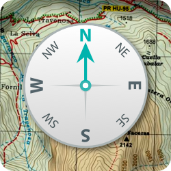
Choose the type of navigation that best suits the type of activity you are going to do: free navigation, follow a track, go to specific coordinates, compass navigation... or simply let yourself be guided by following the indications of a roadbook
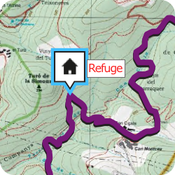
Add information to your route by creating your own waypoints on the GPS screen. Click on the exact place where you want to create a point and add a name, icon and description (refuge, lake, fountain...)
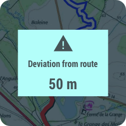
Achieve the security you are looking for on your outdoor activities, if you deviate from the planned route, the GPS will notify you so that you can redirect your activity. In addition, if you exceed speed limits, heart rate... you will also receive a warning
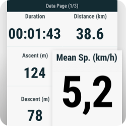
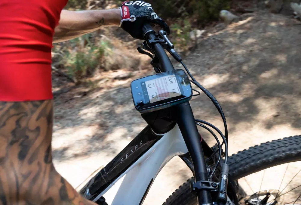
Track more than 200 data in real time (height, distance, ascent, power, speed...). If you have a heart rate monitor or cadence monitor, connect it and you will receive more information
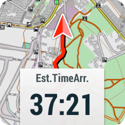
Let the GPS guide you to destination, you will always know the distance and the remaining time. When you are back, the GPS will calculate the shortest route to return home or to the starting point
Know the relief of the terrain you are about to face from the GPS. With TwoNav you can load maps from the main cartographic publishers and move around them. Get more detail on paths and shortcuts
Choose the type of navigation that best suits the type of activity you are going to do: free navigation, follow a track, go to specific coordinates, compass navigation... or simply let yourself be guided by following the indications of a roadbook
Add information to your route by creating your own waypoints on the GPS screen. Click on the exact place where you want to create a point and add a name, icon and description (refuge, lake, fountain...)
Achieve the security you are looking for on your outdoor activities, if you deviate from the planned route, the GPS will notify you so that you can redirect your activity. In addition, if you exceed speed limits, heart rate... you will also receive a warning
Track more than 200 data in real time (height, distance, ascent, power, speed...). If you have a heart rate monitor or cadence monitor, connect it and you will receive more information
Let the GPS guide you to destination, you will always know the distance and the remaining time. When you are back, the GPS will calculate the shortest route to return home or to the starting point
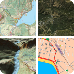
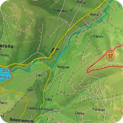
Designed for the mountains, these maps display the terrain relief you are about to tread on. Contour lines will give you an idea of the area's difficulty. You'll find paths, shortcuts, national parks, lakes...
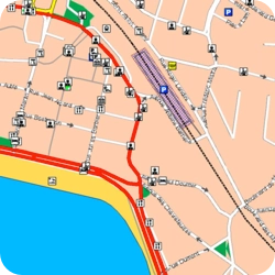
Typically urban and interurban maps, used for car or motorcycle navigation, including all kinds of road information: street names, directions, notable points of interest such as hospitals, hotels, restaurants, gas stations...
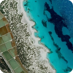
Aerial photographs taken by satellites, allowing you to quickly identify elements of the landscape wherever you are, whether in the mountains or the city: fields, lakes, shelters, buildings, roads...
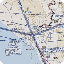
If you engage in aerial activities such as paragliding, ultralight flying, gliding, or ballooning, use these maps to easily find landing strips and restricted flight areas
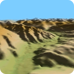
The three-dimensional view allows you to simulate the environment of your adventure with a very realistic recreation of the destination. Move freely through the 3D simulation and comfortably assess the difficulty of your route
If you have your own maps or want to use other types (nautical, aeronautical...), you have 32 GB of memory to supplement the included GPS mapping with many other maps
Designed for the mountains, these maps display the terrain relief you are about to tread on. Contour lines will give you an idea of the area's difficulty. You'll find paths, shortcuts, national parks, lakes...
Typically urban and interurban maps, used for car or motorcycle navigation, including all kinds of road information: street names, directions, notable points of interest such as hospitals, hotels, restaurants, gas stations...
Aerial photographs taken by satellites, allowing you to quickly identify elements of the landscape wherever you are, whether in the mountains or the city: fields, lakes, shelters, buildings, roads...
If you engage in aerial activities such as paragliding, ultralight flying, gliding, or ballooning, use these maps to easily find landing strips and restricted flight areas
The three-dimensional view allows you to simulate the environment of your adventure with a very realistic recreation of the destination. Move freely through the 3D simulation and comfortably assess the difficulty of your route
If you have your own maps or want to use other types (nautical, aeronautical...), you have 32 GB of memory to supplement the included GPS mapping with many other maps
Perfectly planned routes, high-quality maps, and cloud storage

Pair the GPS with the Link™ App on smartphone and you will receive WhatsApp notifications, calls and warnings on the GPS screen. If you store tracks on your smartphone, transfer them to the GPS with Link™

In unknown situations asking for help is essential. With SeeMe™ you broadcast your activity live wherever you are, in addition, you can also send emergency notifications to your contacts

Turn on the GO™ Cloud sync and your activities will be automatically saved to your virtual space, a safe place to store your tracks. Wherever you are, access your activity history from your GPS, smartphone or the internet
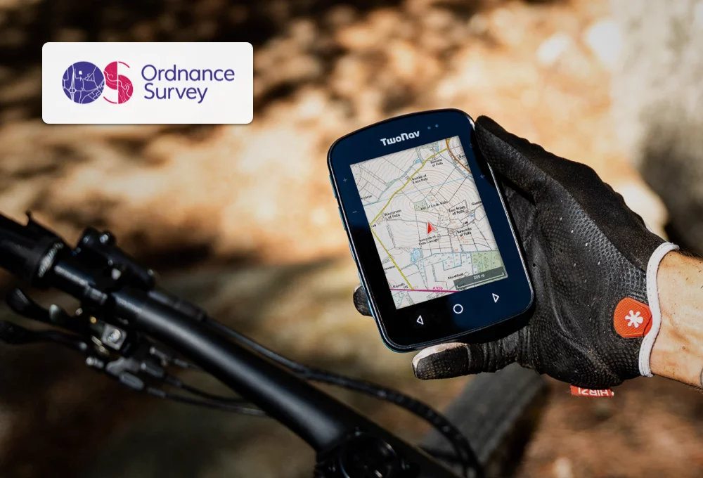
Terra includes a highly accurate Ordnance Survey topographic map for you to explore freely and use when in doubt. Use the maps to find alternate routes and visit other points of interest near you.
If you prefer, you can also choose a different combination of maps from the main cartographic publishers of each country
Set yourself the challenge of exploring unknown areas until now, do it knowing that Terra will follow you at all times and detect a satellite signal wherever you are. Terra has 4 positioning networks with global coverage (GPS + Galileo + Glonass + Beidou). Also, unlike a smartphone, Terra is much more powerful as its recording accuracy is more detailed.
If you enjoy the mountains practicing bikepacking, go one step further and experiment with Roadbooks. Roadbooks are tracks enriched with photographs and comments about the area you are going to visit. Terra will show you interesting information about each place as you pedal. If you are more of action and train for MTB or cross country competitions, use the training functions by time/distance and evaluate your performance by sections.
It is as important to equip yourself as it is to equip your adventure partner. Terra makes it easy for you as it is compatible with many hiking and biking accessories. With the QuickLock support you will fix Terra to the handlebar or stem of your bike. In addition, if you also practice hiking, equip yourself with the belt or backpack accessories and you will always have the GPS at hand in any situation without hardly noticing it.
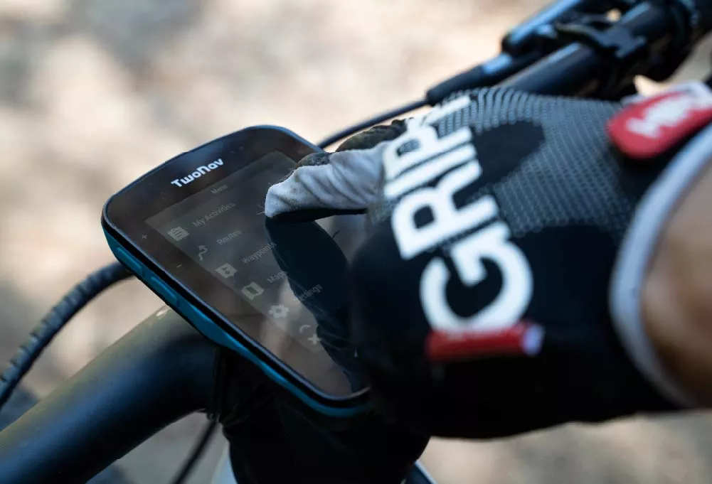
Terra is prepared to resist everything. Its battery is protected by a completely waterproof case, so you will achieve a GPS resistant to mud, dust and water that will not stop your desire for action. Easily manage the GPS even with gloves, with its 4 side buttons you will have total control of Terra even in the rain.
Maximize safety on your adventures with Terra and access a PRO subscription for 6 months that provides you with an essential set of tools to enhance your experience: - Software Land: Outdoor trip preparation and analysis from your PC - App TwoNav: Guidance, navigation, and training on your smartphone - Mapas Plus: Accurate and high-quality maps from around the world - GO Cloud: Your virtual storage space in the TwoNav Cloud
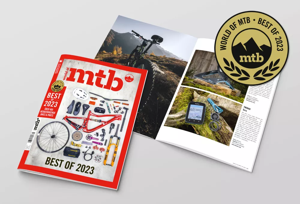
World of MTB, the german magazine of reference in the world of mountain biking, chooses Terra as the best GPS of 2023. World of MTB highlights the screen, map quality, connectivity and synchronization with other training applications.

Terra demonstrates his leadership as the winning GPS of the toughest race in the desert. Terra has been decisive for the team led by Melcior Mauri, TwoNav ambassador, to be able to find their way around the desert without any kind of help or signposting, only with the help of Terra. How do they do that? They use the GPS to know the terrain and the obligatory way points. So they can prepare the shortest route with the greatest precision and speed.
Know moreDare to visit areas that you didn't know, the GPS will suggest routes from all over the world recommended by other users. Select the best itinerary... and navigate it! Once finished, share your activity instantly with friends on your social networks. Synchronize your latest activity anywhere in the world so that other fans get to know your achievements
| Physical characteristics | |
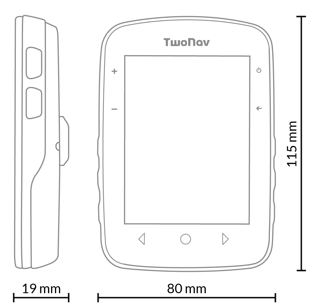
| Dimensions | 80 x 115 x 19* mm *23 mm con QuickLock |
| Weight | 198 gr |
| Buttons | 3 front + 4 side |
| Joystick | |
| Water/dust/mud resistant | IP67 |
| MIL-STD-810 certification |
Temperature, shock, water and vibration |
| Resistant to extreme temperatures | -20 °C ~ 70 °C |
| Screen | |
| Type | Blanview with Optical Bonding and automatic backlight |
| Touch | |
| Dimensions | 3.7’’ |
| Resolution | 480 x 640 pixels |
| Backlight | |
| Storage | |
| Internal memory | 32 GB (free: 28 GB) |
| Memory-card slot | |
| Power supply | |
| Light sensor | |
| Battery capacity | 2600 mAh |
| Normal battery life | 15 h |
| Battery type | Integrated |
| Optional AA batteries | |
| Comm port | USB-C |
| Tools | |
| Full connect | |
| GPS | |
| Galileo | |
| Glonass | |
| Beidou | |
| SBAS/EGNOS | |
| ANT+™ | |
| Bluetooth | Dual |
| GPRS | |
| Wi-Fi | 2,4 Ghz / 5 Ghz |
| Audio | Speaker |
| Barometer | |
| Digital compass | |
| Accelerometer | |
| Functions | |
| Customisable sports profiles | |
| Map overlay | |
| 3D map display | |
| Create unlimited waypoints, routes and tracks | |
| Download maps and routes from online providers | |
| Advanced route editing | |
| Calculate on-road navigation | |
| Estimated time of arrival at destination | |
| Workouts by time, distance, heart rate and pace | |
| TrackAttack workouts | |
| Estimate of calories burned | |
| Adjustable alarms | |
| Automatic and manual laps | |
| Real-time altitude graphic | |
| Over 200 real-time data fields | |
| Customisable data pages | |
| Customisable device buttons | |
| Live broadcast with SeeMe™ | |
| Emergency alerts with SeeMe™ | |
| Compatible with geocaching | |
| Compatible with e-Roadbooks | |
| Auto-sync with the GO cloud™ |

With Terra you can combine all your activities on the same device: hiking, mountain biking, gravel, enduro... Use it on hiking routes or on the bike, just attach Terra to a bike mount. Easy and fast. Take Terra with you and trust GPS when tackling unfamiliar terrain or unmarked paths
Matos Vélo
France

There is no real competitor when it comes to cartography and its advanced cartographic functions such as 3D. Moreover, the ecosystem of additional features that come along with Terra is very complete. Terra is the ideal GPS for "explorers" who are constantly looking for new tracks and routes
Bike Cafe
France

Terra has the best screen on the market today. The Terra screen sweeps the Garmin Edge (the top of the Garmin range) by a landslide. In any type of situation, Terra's screen is better than Karoo 2's in terms of map and data visibility
Bikespot
Spain

The biggest competitor, Garmin, currently has nothing comparable to Terra to offer. In addition, it is not foreseeable that in a near future Garmin will launch any new outdoor handheld device. Currently, Terra is the best GPS for cycling and outdoors that any European manufacturer can offer!
Navigation Professionell
Germany
With Terra you can combine all your activities on the same device: hiking, mountain biking, gravel, enduro... Use it on hiking routes or on the bike, just attach Terra to a bike mount. Easy and fast. Take Terra with you and trust GPS when tackling unfamiliar terrain or unmarked paths
Matos Vélo
France
There is no real competitor when it comes to cartography and its advanced cartographic functions such as 3D. Moreover, the ecosystem of additional features that come along with Terra is very complete. Terra is the ideal GPS for "explorers" who are constantly looking for new tracks and routes
Bike Cafe
France
Terra has the best screen on the market today. The Terra screen sweeps the Garmin Edge (the top of the Garmin range) by a landslide. In any type of situation, Terra's screen is better than Karoo 2's in terms of map and data visibility
Bikespot
Spain
The biggest competitor, Garmin, currently has nothing comparable to Terra to offer. In addition, it is not foreseeable that in a near future Garmin will launch any new outdoor handheld device. Currently, Terra is the best GPS for cycling and outdoors that any European manufacturer can offer!
Navigation Professionell
Germany
Select your country to see what maps are included with the GPS.
By default, you will receive the device with the maps for the country to which it is shipped. If you'd rather get it with maps for another country, please write to orders[at]twonav.com before placing your order.
Ask our Support Team
Contact Secure Payment
 Free shipping on orders over €60 (EU)
 Hassle-free returns


 Austria
  Belgium
  Canada
  Denmark
  Finland
  France
  Germany
  Ireland
  Italy
Italy  Netherlands
  Norway
  Poland
  Portugal
  Russia
  Spain
Spain  Sweden
  Switzerland
  United Kingdom
  United States of America
  Rest of Europe