There are a few ways to hike up to the top of Mount Kosciuszko, but none compare to the views and experience of walking to the top of Australia’s tallest mountain via the Main Range Track. This trail is significantly longer than the other options, but along the way you will escape the crowds, see stunning alpine lakes, mountain galore and views that are out of this world.
Summiting Mount Kosciuszko is merely the icing on the cake, as this walk is easily one of the best in NSW. Here’s everything you need to know about the Mount Kosciuszko Hike, one of our favourites in Australia.
The Mount Kosciuszko Hike via the Main Range Track
Distance: 24.7km (you can lose 3km if you don’t want to walk to the Blue Lake)
Elevation: 910m
Difficulty: Hard
The Main Range Track is a combination of a few trails. It starts from Charlotte’s Pass with the Blue Lake Walk, before merging to the Main Range Track. Then it becomes the Mueller Pass Trail before finishing with the Summit Walk.
Be prepared
This walk is a bit of a beast, with several steep climbs over a long distance, and we recommend allowing 5-8 hours to do the entire walk - there are plenty of great places to stop and admire the views along the way. The terrain is great though so you don’t need to worry about track conditions. The only difficulty comes from the length of the walk combined with the elevation and in our case the continued exposure to gale force winds!
Check the weather forecast but expect any weather as in the mountains it can change quickly. Even in the summer, temperatures can drop and rain can come in out of nowhere (sometimes even snow), so make sure you have packed a rain jacket and an extra layer.

Starting the trail - the Blue Lake Walk
The Mount Kosciuszko hike via the Main Range Track starts from the carpark at Charlotte’s Pass. The spaces at the car park have a 20 minute time allocation, so you’ll have to park along the road, it can get busy but you’ll always find somewhere to park, it just might add on a little extra walking!
The hike begins with a bang, heading downhill for 1km towards the Snowy River. It’s always slightly unnerving to be going downhill when you know you have a big climb ahead, but it does provide an epic view to kick off with!
It’s spectacular right from the start, especially on a clear sunny day when you can see the surrounding mountain tops. There were still some snowy patches around, despite it being mid December, and I can only imagine it looks even more special a bit earlier in the hiking season when there would be a lot more snow.

There are two rivers to cross right at the beginning of the walk, and both have several stepping stones to hop easily across before you begin heading uphill. The trail continues pretty steadily uphill for the next 2.5km before reaching a crest of one of the hills.
The scenery is gorgeous all the way and there are plenty of photo opportunities to stop for and have a breather. The path is really well graded which makes the climb a lot easier.


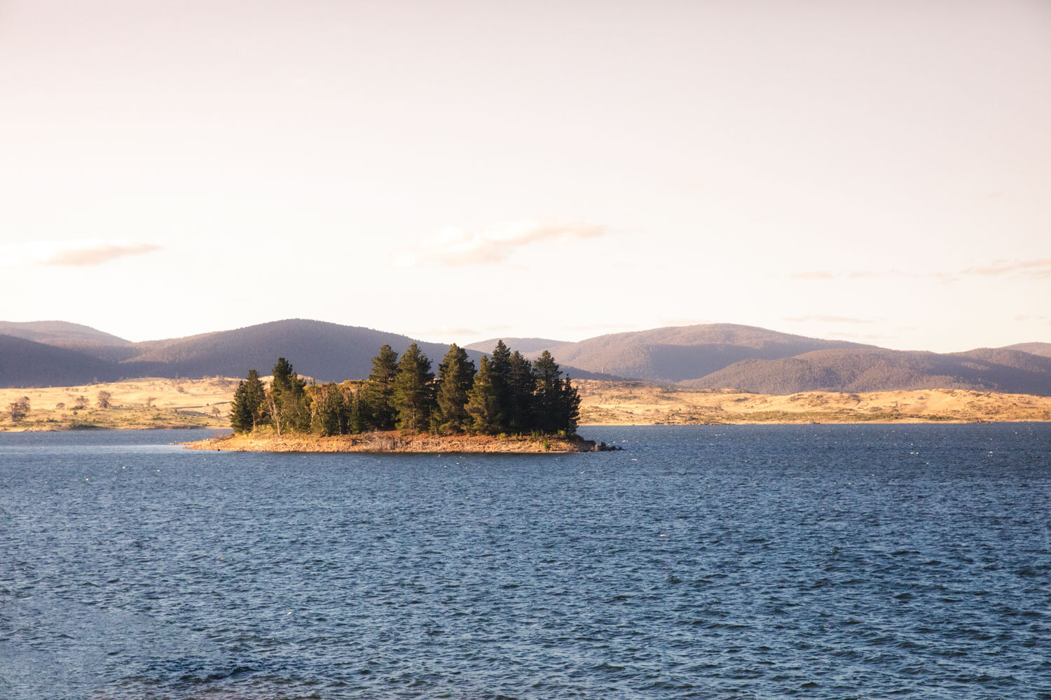
From here, it’s a slightly demoralising downhill for 500m (elevation you’ll have to claw back) before crossing Carruther’s Creek and heading uphill to the ridge for the Blue Lake. The views are wonderful and it’s only really the ferocious wind which made it a bit of a challenge, you can’t tell from the pictures but it was probably the windiest walk we have ever done!

Side Trail: To Blue Lake or not to Blue Lake?
At this point you have a choice: continue on the main trail, or take a detour right, to see the Blue Lake. By now you’ve walked 4.3km and hiked up 310m of elevation, so we don’t blame you for thinking there’s a lot more hiking to do and powering on!

However, it’s well worth hiking the extra 1.4km down to the Blue Lake. The path isn’t as smooth as the rest of the track, but you will get to see one of only four glacier lakes in Australia up close (you can see it from the junction, but the view isn’t as good). You can choose simply to walk to the lookout for the lake - which is 350m along the path - or head down to the shore.

We enjoyed the views from the shore, where you can see the huge cliff at the other side of the lake and the river flowing from it. It will add 2.75km more onto the walk total (and an extra 100m of elevation) but it is well worth the extra effort, especially when you think that glacier lakes are so rare in Australia!
The wind was really whipping up the water when we visited so the photos do not do this lake justice, it is absolutely beautiful and very, very blue.


After the lake, you’ll head back to the Main Range Trail again. From the Blue Lake onward the trail only gets more and more incredible as the scenery becomes increasingly dramatic.
Onto Carruthers Peak
Once you’re back on the main trail, it’s back to the uphill climb again, this time towards the seventh highest mountain in Australia: Carruthers Peak.


The trail starts off being shallower at first, before climbing more steeply and reaching a jaw dropping view across to the mountain ranges in the west. I think this might just be the best view on the entire trail - and that’s saying something. It really will stop you in your tracks.
We did this trail on a clear day, but the ferocious wind made it hard to stand still in an exposed patch like this otherwise it would have been a hard spot to leave! If you have less wind than us, it’s also a great place to take a little break before the next part of the hike.

From the ‘viewpoint’ (it’s not an official lookout) it’s a pretty steep 1km walk uphill to the summit of Carruthers Peak. The vista from here is again spectacular, and for the first time you will get glimpses of Albina Lake and the summits surrounding Kosciuszko in the distance.


The good news is that the majority of the climbing is done and there is a long relaxing stretch of track to come before the final climb up to the summit.

A long respite
After Carruthers Peak the trail continues to be incredible and the fact it is mainly flat means it feels really leisurely and you can fully take in all your surroundings.

The trail winds downhill before connecting with a metal boardwalk, walking past some more phenomenal views before reaching Albina Lake. I really loved the 1.7km boardwalked section where footing is a breeze (not that any of it is difficult terrain but you don’t have to even look at the ground at all when you’re on the boardwalk).
The views are panoramic and the whole way along I kept thinking that already this walk had made it into my favourite hikes in Australia list.


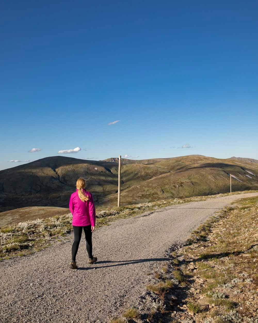
After the boardwalk the trail goes back to a stoney path and begins to ascend steadily. From here you can see the summit of Mount Kosciuszko ahead of you. We’ll admit it doesn’t look overly grand from here, in fact it doesn’t really from anywhere along the track, more of a hump than the tallest mountain in Australia! But that doesn’t make it any less wonderful when you get there.
There are wildflowers sprinkled throughout most of the track but in this next part there were suddenly so many more, they were everywhere. It was the most we’d seen on any walk in NSW until we later did the Mount Stilwell Track which pipped it (for density as that’s only a short walk).
There were lots of different varieties, but the most abundant were the gorgeous Snow daisies. They added even more magic to an already very special track.

After meandering on a mainly flat or very slightly uphill track you finally come to the final push to the top. After seeing no one all day, we suddenly saw a group of 20 super-fit rowers come out of nowhere (super fit rowers who said they’d only taken 2 hours to hike the 13km uphill to this point!!!).


We happily let them overtake us en mass so we could continue our slow plod up the stairs. And there are rather a lot of stairs, which provide a little kick of steepness in the final kilometre to the junction before the summit.

Reaching the summit
After 14km you will join the Summit Walk and are within 1km of the highest point in Australia. Normally this is where you would suddenly converge with all the people walking the much more popular track from the top of the Thredbo chairlift.
Luckily for us as we were here just two hours before sunset (by design, as we were hoping for a peaceful time at the top), there wasn’t anyone else coming up!

Unlike many mountain summits, the path is manicured and paved - a necessity with hundreds of people hiking this trail every day during peak season.
The trail winds alongside a rocky landscape and is much shallower than the staircases you have already walked to the junction. It makes the ending feel nice and easy by comparison.

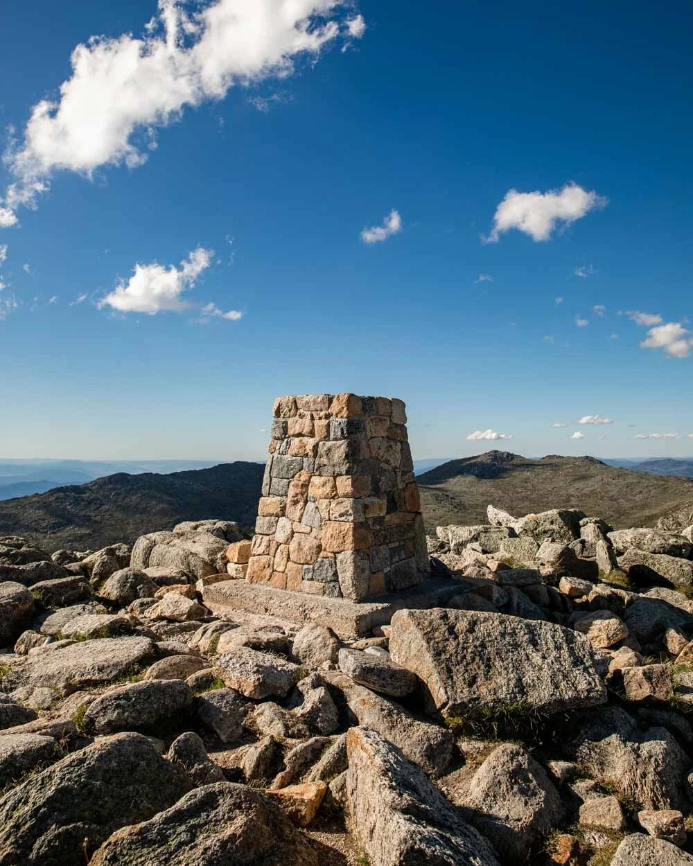
It’s not long before you curve round the corner and arrive at the stone trig which marks the summit. The views are great, with layer upon layer of mountains, but in our opinion not quite as good as some of the views earlier along the trail. It’s still a great feeling to be there though and there’s lots of places to sit and relax.
We were incredibly lucky that the rowers had moved on and we got the entire summit to ourselves! We couldn’t have asked for a better experience and if you don’t mind finishing up the walk at sunset, we’d highly recommend coming later in the day. We’ve seen pictures where the summit can be body to body during the day in high season.


We’d taken just over 4 hours to hike up to the top of Mount Kosciuszko, going steadily and enjoying the views along the way. The quickest seem to take between 2- 3 hours, stopping briefly at the top and then racing back down again.

Finishing the Mount Kosciuszko Hike
The good news is that the uphill parts of the walk are done. From here, the trail is almost entirely downhill. From the summit, the trail follows the wide Summit Path down to Rawsons Pass. You can use the highest toilets in Australia here if you need!
The track all the way back to the car park is a wide fire trail, that is a bit mundane compared to the rest of the walk. The scenery is still very pretty, but nothing like what you have seen so far. It can also be used by mountain bikes but luckily we were too late to see any!
After 3km from leaving the summit you’ll reach Seaman’s Hut, a small building that can be used by day walkers in emergency conditions. It’s named after Laurie Seaman, who - with his partner Evan Hayes - tragically died after going to ski down from Mount Kosciuszko in 1928, and is one of the many historic alpine huts in the Snowy Mountains.
You can pop in and have a look around, you just can’t sleep there unless it’s an emergency.


From Seamans Hut, the trail heads for 6km down towards the Snowy River once more before arriving back at Charlottes Pass. Unlike the early part of the trail which doesn’t have any signs with distances, there are markers counting you down kilometre by kilometre. We were lucky to be walking this section close to sunset when the whole area was bathed in golden light which definitely added to the beauty.
We arrived back just before sundown and headed over to Charlotte Pass Lookout to watch the last rays of the sun (it was only something like 50m extra walking so we’d definitely recommend it if you are around at a similar time). You get a fabulous view over to Kosciuszko and the Main Range and it’s a satisfying end to one of the best walks in the country.


Essential info about the the Mount Kosciuszko Hike
(via the Main Range Track)
Where to park for the trail
The trail departs from the Charlotte Pass car park, but it only allows you 20 minutes parking here, so you’ll need to park at the side of the road.
It can get very busy as many trails depart from here, you’ll still be able to park, you just might have a little extra uphill walking to do!
Charlotte’s Pass is a 40 minute drive from Jindabyne or 1 hour from Thredbo.
The Mount Kosciuszko National Park Fee
The Main Range Track falls within the park fee zone and even if you have an NSW parks pass, you still need to pay. The fee is $17 per day, and if you buy 4 days you get 1 free. You can buy an annual pass for just this park alone for $190.
The pass lasts for 24 hours, so if you time it right you can hike for 2 days on a 1 day pass.
Trail closure dates
The walk is generally under snow between June and October and over the winter months the road is closed to private vehicles. Even outside this period, there could still be lingering snow but generally speaking it is clear in summer. If you’re walking when there might be a light snow covering, Yaktrax will be hugely helpful.
This post may contain affiliate links, meaning at no additional cost to you, that we will earn a small commission if you click through and decide to make a purchase. This helps towards the costs of running our website. Thanks for your support!
Like it? Pin it!

Follow us on Social Media
Have you done the Mount Kosciuszko Hike? What’s your favourite hike in NSW? Let us know in the comments below!