Skip to content
NOWCAST WGAL News 8 Today at 6:00am
Watch on Demand
Advertisement

Have you witnessed any of these clouds before?

The News 8 Storm Team takes a closer look at rare cloud structures and how they form

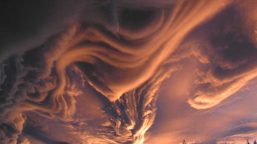
Undulatus Asperatus
NASA.GOV
Undulatus Asperatus
SOURCE: NASA.GOV
Advertisement
Have you witnessed any of these clouds before?
The News 8 Storm Team takes a closer look at rare cloud structures and how they form
An incredible cloud formation was caught on camera this week over Lexington, Kentucky.Photos: See photos of rare clouds Connect: Like the News 8 Storm Team on Facebook The image has gone viral all over social media and it prompted the News 8 Storm Team to think about rare cloud formations and how they are created. Here's some things to know about rare clouds:Undulatus AsperatusThe Undulatus Asperatus is the newest cloud classification in the World Meteorological Organization’s “International Cloud Atlas”, and is the cloud formation front-and-center in the viral picture taken in Kentucky on August 3rd.The term Undulatus Asperatus is Latin for “agitated waves”. These clouds form when there is turbulence in the skies, creating wave-like patterns in flat stratiform clouds that really do look like waves in a rough ocean if you were viewing from underneath! These clouds are a striking testament to the fact that the atmosphere behaves, and sometimes even resembles, a fluid – in fact, many of the same physics principles that govern the oceans also work for the atmosphere!Click here to see a time-lapse on Facebook from the National Weather Service.Mammatus CloudsA cousin to the Undulatus Asperatus cloud formations are Mammatus Clouds. These pouch-like formations are also created due to turbulence in the skies, usually associated with the upward and downward motion created by thunderstorms!You’ll typically be able to spot mammatus clouds on the underside of a thunderstorm “anvil”. They are very common sights after a strong thunderstorm has passed through, or before the storm hits. Many people believe that mammatus clouds are a sign that a storm will produce a tornado, but that simply isn’t true. In fact, these formations can even form on non-severe storms. However, it does take a certain criteria of atmospheric conditions and the right vantage point to catch a glimpse of these unique formations!Kelvin-Helmholtz Wave CloudsOne of the most rare of all cloud formations is the Kelvin-Helmholtz “wave”. The reason they’re so rare is due to the fact that typically these formations only last for a couple of minutes before dissipating, and atmospheric conditions have to be exactly right in order to see them form.These clouds appear to be little “hooks” in the sky and are created by rolling eddies in the atmosphere. When two layers of atmosphere, containing different densities, have winds traveling at different speeds, the faster layer will scoop up the slower layer, producing the eddies and creating the clouds structures that this phenomenon produces. Usually this process is very quick (on the order of a couple of minutes) before the densities or winds change and therefore the structure falls apart. If you get a chance to see K-H Waves, consider yourself lucky!Click here to see a K-H wave time-lapse on YouTube.Roll CloudsA roll cloud is a low, horizontal tube-shaped cloud formation that is typically, but not always, found on the leading edge of a strong or severe thunderstorm. If associated with a thunderstorm, these clouds are created by the storm’s downdraft (air rushing out of the storm to the ground) hitting the ground, and spreading out. As the cooler air undercuts warmer air, the warm air lifts and condenses, forming this tube-like structure that is separate from the thunderstorm itself.Sometimes these roll clouds can look like tornadoes, due to witnesses’ vantage points to the phenomenon. However, these formations are a sign of strong straight-line winds being produced within the storm itself and be associated with severe thunderstorms.Shelf CloudsOur final rare cloud formation is the shelf cloud! Related to the roll cloud, a shelf cloud is a little different because it’s actually attached to the storm itself, whereas the roll cloud is separated from the source.Similar to a roll cloud, the shelf cloud is typically associated with stronger winds (possibly downdrafts and microbursts), hitting the ground and expanding outward. The rain-cooled air forces the warmer air up, condensing the water vapor and forming shelf-like structures that are very common in strong to severe lines of thunderstorms.A shelf cloud was spotted and captured earlier this year in the Susquehanna Valley, and the image went viral. If you see a shelf cloud, there’s a pretty high chance that high winds will arrive within minutes – you should take cover immediately!Click here to see the image and LIKE the News 8 Storm Team on Facebook.

An incredible cloud formation was caught on camera this week over Lexington, Kentucky.

Photos: See photos of rare clouds 

Advertisement

Related Content

Connect: Like the News 8 Storm Team on Facebook 

The image has gone viral all over social media and it prompted the News 8 Storm Team to think about rare cloud formations and how they are created. 

Here's some things to know about rare clouds:

Undulatus Asperatus

The Undulatus Asperatus is the newest cloud classification in the World Meteorological Organization’s “International Cloud Atlas”, and is the cloud formation front-and-center in the viral picture taken in Kentucky on August 3rd.

The term Undulatus Asperatus is Latin for “agitated waves”. These clouds form when there is turbulence in the skies, creating wave-like patterns in flat stratiform clouds that really do look like waves in a rough ocean if you were viewing from underneath! These clouds are a striking testament to the fact that the atmosphere behaves, and sometimes even resembles, a fluid – in fact, many of the same physics principles that govern the oceans also work for the atmosphere!

Undulatus Asperatus
NASA.GOV

Click here to see a time-lapse on Facebook from the National Weather Service.

Mammatus Clouds

A cousin to the Undulatus Asperatus cloud formations are Mammatus Clouds. These pouch-like formations are also created due to turbulence in the skies, usually associated with the upward and downward motion created by thunderstorms!

You’ll typically be able to spot mammatus clouds on the underside of a thunderstorm “anvil”. They are very common sights after a strong thunderstorm has passed through, or before the storm hits. Many people believe that mammatus clouds are a sign that a storm will produce a tornado, but that simply isn’t true. In fact, these formations can even form on non-severe storms. However, it does take a certain criteria of atmospheric conditions and the right vantage point to catch a glimpse of these unique formations!

Mammatus Clouds
http://www.srh.weather.gov

Kelvin-Helmholtz Wave Clouds

One of the most rare of all cloud formations is the Kelvin-Helmholtz “wave”. The reason they’re so rare is due to the fact that typically these formations only last for a couple of minutes before dissipating, and atmospheric conditions have to be exactly right in order to see them form.

These clouds appear to be little “hooks” in the sky and are created by rolling eddies in the atmosphere. When two layers of atmosphere, containing different densities, have winds traveling at different speeds, the faster layer will scoop up the slower layer, producing the eddies and creating the clouds structures that this phenomenon produces. Usually this process is very quick (on the order of a couple of minutes) before the densities or winds change and therefore the structure falls apart. If you get a chance to see K-H Waves, consider yourself lucky!

Kelvin-Helmholtz Wave Clouds
http://en.es-static.us

Click here to see a K-H wave time-lapse on YouTube.

Roll Clouds

A roll cloud is a low, horizontal tube-shaped cloud formation that is typically, but not always, found on the leading edge of a strong or severe thunderstorm. If associated with a thunderstorm, these clouds are created by the storm’s downdraft (air rushing out of the storm to the ground) hitting the ground, and spreading out. As the cooler air undercuts warmer air, the warm air lifts and condenses, forming this tube-like structure that is separate from the thunderstorm itself.

Sometimes these roll clouds can look like tornadoes, due to witnesses’ vantage points to the phenomenon. However, these formations are a sign of strong straight-line winds being produced within the storm itself and be associated with severe thunderstorms.

Roll Clouds
http://www.srh.noaa.gov

Shelf Clouds

Our final rare cloud formation is the shelf cloud! Related to the roll cloud, a shelf cloud is a little different because it’s actually attached to the storm itself, whereas the roll cloud is separated from the source.

Similar to a roll cloud, the shelf cloud is typically associated with stronger winds (possibly downdrafts and microbursts), hitting the ground and expanding outward. The rain-cooled air forces the warmer air up, condensing the water vapor and forming shelf-like structures that are very common in strong to severe lines of thunderstorms.

A shelf cloud was spotted and captured earlier this year in the Susquehanna Valley, and the image went viral. If you see a shelf cloud, there’s a pretty high chance that high winds will arrive within minutes – you should take cover immediately!

Shelf Clouds
WGAL Storm Team Facebook

Click here to see the image and LIKE the News 8 Storm Team on Facebook.