Pike CNHI - Pennsylvania Natural Heritage Program
Pike CNHI - Pennsylvania Natural Heritage Program
Pike CNHI - Pennsylvania Natural Heritage Program

Create successful ePaper yourself
Turn your PDF publications into a flip-book with our unique Google optimized e-Paper software.
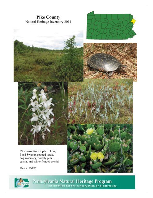
<strong>Pike</strong> County<br />
<strong>Natural</strong> <strong>Heritage</strong> Inventory 2011<br />
Clockwise from top left: Long<br />
Pond Swamp, spotted turtle,<br />
bog rosemary, prickly pear<br />
cactus, and white-fringed orchid<br />
Photos: PNHP
PIKE COUNTY<br />
NATURAL HERITAGE INVENTORY<br />
July 2011<br />
Prepared for:<br />
<strong>Pike</strong> County Planning Commission<br />
837 Route 6, Unit 4<br />
Shohola, PA 18458<br />
Prepared by:<br />
<strong>Pennsylvania</strong> <strong>Natural</strong> <strong>Heritage</strong> <strong>Program</strong><br />
Western <strong>Pennsylvania</strong> Conservancy<br />
800 Waterfront Drive<br />
Pittsburgh, <strong>Pennsylvania</strong> 15222<br />
The <strong>Pennsylvania</strong> <strong>Natural</strong> <strong>Heritage</strong> <strong>Program</strong> (PNHP) is a partnership between the Western <strong>Pennsylvania</strong><br />
Conservancy (WPC), the <strong>Pennsylvania</strong> Department of Conservation and <strong>Natural</strong> Resources (DCNR), the<br />
<strong>Pennsylvania</strong> Game Commission (PGC), and the <strong>Pennsylvania</strong> Fish and Boat Commission (PFBC).<br />
PNHP is a member of NatureServe, which coordinates natural heritage efforts through an international<br />
network of member programs—known as natural heritage programs or conservation data centers—<br />
operating in all 50 U.S. states, Canada, Latin America and the Caribbean.<br />
This project was funded through grants supplied by the DCNR Wild Resource Conservation<br />
<strong>Program</strong>, the <strong>Pike</strong> County Scenic Rural Character Preservation <strong>Program</strong>, and the <strong>Pike</strong> County<br />
Conservation District<br />
Copies of this report are available in electronic format through the <strong>Pennsylvania</strong> <strong>Natural</strong> <strong>Heritage</strong><br />
<strong>Program</strong> website, www.naturalheritage.state.pa.us, and through the <strong>Pike</strong> County Planning Commission.
Preface<br />
The <strong>Pennsylvania</strong> <strong>Natural</strong> <strong>Heritage</strong> <strong>Program</strong> (PNHP) is responsible for collecting, tracking, and<br />
interpreting information regarding the Commonwealth’s biological diversity. County <strong>Natural</strong> <strong>Heritage</strong><br />
Inventories (<strong>CNHI</strong>s) are an important part of the work of PNHP. Since 1989, PNHP has conducted<br />
county inventories as a means to both gather new information about natural resources and to pass this<br />
information along to those responsible for making decisions about the resources in the county, including<br />
the community at large. This County <strong>Natural</strong> <strong>Heritage</strong> Inventory focuses on the best examples of living<br />
ecological resources in <strong>Pike</strong> County. The county must address historic, cultural, educational, water<br />
supply, agricultural, and scenic resources through other projects and programs. Although the inventory<br />
was conducted using a tested and proven methodology, it is best viewed as a preliminary report on the<br />
county’s natural heritage. Further investigations could, and likely will, uncover previously unidentified<br />
areas of significance. Likewise, in-depth investigations of sites listed in this report could reveal features<br />
of further or greater significance than have been documented. We encourage additional inventory work<br />
across the county to further the efforts begun with this study. Keep in mind that there will be more places<br />
to add to those identified here and that this document can be updated as necessary to accommodate new<br />
information.<br />
Consider this inventory as an invitation for the people of <strong>Pike</strong> County to explore and discuss their natural<br />
heritage and to learn about and participate in the conservation of the living ecological resources of the<br />
county. Ultimately, it will be up to the landowners, residents, and officials of <strong>Pike</strong> County to determine<br />
how to use this information. Several potential applications for the information within the County <strong>Natural</strong><br />
<strong>Heritage</strong> Inventory for a number of user groups follow:<br />
Planners and Government Staff. Typically, the planning office in a county administers county<br />
inventory projects. The inventories are often used in conjunction with other resource information<br />
(agricultural areas, slope and soil overlays, floodplain maps, etc.) in review for various projects and in<br />
comprehensive planning. <strong>Natural</strong> <strong>Heritage</strong> Areas may be included under various zoning categories, such<br />
as conservation or forest zones, within parks and greenways, and even within agricultural security areas.<br />
There are many possibilities for the conservation of <strong>Natural</strong> <strong>Heritage</strong> Areas within the context of public<br />
amenities, recreational opportunities, and resource management.<br />
County, State and Federal Agencies. In many counties, <strong>Natural</strong> <strong>Heritage</strong> Areas lie within or include<br />
state or federal lands. Agencies such as the <strong>Pennsylvania</strong> Game Commission, the <strong>Pennsylvania</strong> Bureau of<br />
Forestry, and the Army Corps of Engineers can use the inventory to understand the extent of the resource.<br />
Agencies can also learn the requirements of the individual plant, animal, or community elements and the<br />
general approach that protection could assume. County Conservation Districts may use the inventories to<br />
focus attention on resources (high diversity streams or wetlands) and as a reference in encouraging good<br />
management practices.<br />
Environmental and Development Consultants. Environmental consultants are called upon to plan for a<br />
multitude of development projects including road construction, housing developments, commercial<br />
enterprises, and infrastructure expansion. Design of these projects requires that all resources impacted be<br />
known and understood. Decisions made with inadequate information can lead to substantial and costly<br />
delays. County <strong>Natural</strong> <strong>Heritage</strong> Inventories (<strong>CNHI</strong>s) provide a first look at biological resources,<br />
including plants and animals listed as rare, threatened, or endangered in <strong>Pennsylvania</strong> and in the nation.<br />
Consultants can then see potential conflicts long before establishing footprints or developing detailed<br />
plans and before applying for permits. This allows projects to be changed early on in the process when<br />
flexibility is at a maximum.<br />
<strong>Pike</strong> County <strong>Natural</strong> <strong>Heritage</strong> Inventory – Preface / iii
Environmental consultants are increasingly called upon to produce resource plans (e.g. River<br />
Conservation Plans, Parks and Open Space Plans, and Greenway Plans) that must integrate a variety of<br />
biological, physical, and social information. <strong>CNHI</strong>s can help define watershed-level resources and<br />
priorities for conservation and are often used as the framework for these plans.<br />
Developers. Working with environmental consultants, developers can consider options for development<br />
that add value while protecting key resources. Incorporating greenspace, wetlands, and forest buffers into<br />
various kinds of development can attract homeowners and businesses that desire to have natural amenities<br />
nearby. Just as parks have traditionally raised property values, so too can natural areas. <strong>CNHI</strong>s can<br />
suggest opportunities where development and conservation can complement one another.<br />
Educators. Curricula in primary, secondary and college level classes often focus on biological science at<br />
the chemical or microbiological level. Field sciences do not always receive the attention that they deserve.<br />
<strong>Natural</strong> areas can provide unique opportunities for students to witness, first-hand, the organisms and<br />
natural communities that are critical to maintaining biological diversity. Teachers can use <strong>CNHI</strong>s to show<br />
students where and why local and regional diversity occurs, and to aid in curriculum development for<br />
environment and ecology academic standards. With proper permission and arrangements through<br />
landowners and the <strong>Pennsylvania</strong> <strong>Natural</strong> <strong>Heritage</strong> <strong>Program</strong>, students can visit <strong>Natural</strong> <strong>Heritage</strong> Areas<br />
and establish appropriate research or monitoring projects.<br />
Conservation Organizations. Organizations that have missions related to the conservation of biological<br />
diversity can turn to the inventory as a source of prioritized places in the county. Such a reference can<br />
help guide internal planning and define the essential resources that can be the focus of protection efforts.<br />
Land trusts and conservancies throughout <strong>Pennsylvania</strong> have made use of the inventories to do this sort of<br />
planning and prioritization and are now engaged in conservation efforts on highly significant sites in<br />
individual counties and regions.<br />
<strong>Natural</strong> <strong>Heritage</strong> Inventories and Environmental Review<br />
The results presented in this report represent a snapshot in time, highlighting the sensitive natural areas within<br />
<strong>Pike</strong> County. The sites in the <strong>Pike</strong> County <strong>Natural</strong> <strong>Heritage</strong> Inventory have been identified to help guide wise<br />
land use and county planning. The <strong>Pike</strong> County <strong>Natural</strong> <strong>Heritage</strong> Inventory is a planning tool, but is not meant to<br />
be used as a substitute for environmental review, since information is constantly being updated as natural<br />
resources are both destroyed and discovered. Planning Commissions and applicants for building permits should<br />
conduct free, online, environmental reviews to inform them of project-specific potential conflicts with sensitive<br />
natural resources. Environmental reviews can be conducted by visiting the PNHP website at<br />
http://www.naturalheritage.state.pa.us. If conflicts are noted during the environmental review process, the<br />
applicant is informed of the steps to take to minimize negative effects on sensitive natural resources. A pdf<br />
version of all completed County <strong>Natural</strong> <strong>Heritage</strong> Inventories can also be found on the PNHP website. All<br />
<strong>Natural</strong> <strong>Heritage</strong> Areas identified statewide can be viewed at<br />
http://www.naturalheritage.state.pa.us/cnhi/cnhi.htm.<br />
<strong>Pike</strong> County <strong>Natural</strong> <strong>Heritage</strong> Inventory – Preface / iv
ACKNOWLEDGEMENTS<br />
We would like to acknowledge the many citizens and landowners of the county and surrounding areas<br />
who volunteered information, time, and effort to the inventory and granted permission to access land.<br />
We especially thank:<br />
<strong>Pike</strong> County <strong>Natural</strong> <strong>Heritage</strong> Inventory Advisory Committee, including:<br />
Sally Corrigan – <strong>Pike</strong> County Planning Commission<br />
Scot Boyce – <strong>Pike</strong> County Planning Commission<br />
Nick Dickerson – <strong>Pike</strong> County Planning Commission<br />
Susan Beecher – <strong>Pike</strong> County Conservation District<br />
Nick Spinelli – <strong>Pike</strong> County Conservation District<br />
Tim Ladner – Bureau of Forestry<br />
Sue Currier – Delaware Highlands Conservancy<br />
Amanda Subjin – Delaware Highlands Conservancy<br />
Bud Cook – The Nature Conservancy<br />
Su Fanok – The Nature Conservancy<br />
Scott Savini – Blooming Grove Hunting and Fishing Club<br />
We would also like to thank the <strong>Pennsylvania</strong> Department of Conservation and <strong>Natural</strong> Resources for<br />
providing the funding to make this report possible. Funding was also provided by the <strong>Pike</strong> County Scenic<br />
Rural Character Preservation <strong>Program</strong>, the <strong>Pike</strong> County Conservation District, and the <strong>Pike</strong> County<br />
Commissioners. A special thank-you goes to the people of <strong>Pike</strong> County for their interest and hospitality.<br />
We want to recognize the <strong>Pennsylvania</strong> <strong>Natural</strong> <strong>Heritage</strong> <strong>Program</strong> and NatureServe for providing the<br />
foundation for the work that we perform for these studies. Current and former PNHP staff that contributed<br />
to this report include Jeff Wagner, Rocky Gleason, Andrew Strassman, Charlie Eichelberger, Chris<br />
Tracey, Pete Woods, John Kunsman, Mary Walsh, Ryan Miller, Ephraim Zimmerman, Sally Ray, Beth<br />
Meyer, Jake Boyle, Steve Grund, Tony Davis, Kathy Gipe, Jim Hart, Betsy Leppo, Matt Kowalski, Susan<br />
Klugman, Erika Schoen, and Kierstin Carlson.<br />
Without the support and help from these people and organizations, the inventory would not have seen<br />
completion. We encourage comments and questions. The success of the report will be measured by the<br />
use it receives and the utility it serves to those making decisions about resources and land use throughout<br />
the county. Thank you for your interest.<br />
Denise Watts, Ecologist<br />
<strong>Pennsylvania</strong> <strong>Natural</strong> <strong>Heritage</strong> <strong>Program</strong>
<strong>Pike</strong> County <strong>Natural</strong> <strong>Heritage</strong> Inventory / vi
TABLE OF CONTENTS<br />
How to use this document<br />
The <strong>Pike</strong> County <strong>Natural</strong> <strong>Heritage</strong> Inventory is designed to provide information about the biodiversity of<br />
<strong>Pike</strong> County. The Introduction of the report has an overview of the process behind this inventory as well<br />
as an overview of the <strong>Natural</strong> History of <strong>Pike</strong> County. Results are presented at the broad landscape view,<br />
then move into finer scale results presented by township. <strong>Natural</strong> <strong>Heritage</strong> Areas that cross municipal<br />
boundaries are cross-referenced in each township section. Finally, conclusions and overall<br />
recommendations follow the township sections.<br />
Preface .........................................................................................................................................................iii<br />
Acknowledgements......................................................................................................................................iv<br />
Table of Contents........................................................................................................................................vii<br />
Executive Summary .....................................................................................................................................xi<br />
Introduction...................................................................................................................................................1<br />
County Overview..........................................................................................................................................3<br />
Overview of the <strong>Natural</strong> Features of <strong>Pike</strong> County........................................................................................4<br />
Physiography and Geology .......................................................................................................................5<br />
Soils ..........................................................................................................................................................5<br />
Vegetation.................................................................................................................................................7<br />
Flowing Water and Major Stream Systems ............................................................................................10<br />
Disturbance .............................................................................................................................................13<br />
Invasive Species in <strong>Pike</strong> County.............................................................................................................15<br />
<strong>Natural</strong> Resources ...................................................................................................................................20<br />
A Review of the Animals of <strong>Pike</strong> County...................................................................................................21<br />
Mammals of <strong>Pike</strong> County .......................................................................................................................21<br />
Birds of <strong>Pike</strong> County...............................................................................................................................25<br />
Reptiles and Amphibians of <strong>Pike</strong> County ...............................................................................................27<br />
Fishes of <strong>Pike</strong> County .............................................................................................................................31<br />
Freshwater Mussels of <strong>Pike</strong> County........................................................................................................34<br />
Insects of <strong>Pike</strong> County ............................................................................................................................35<br />
Methods ......................................................................................................................................................39<br />
Site Selection ..........................................................................................................................................39<br />
Ground Surveys ......................................................................................................................................39<br />
Data Analysis and Mapping....................................................................................................................39<br />
Results.........................................................................................................................................................41<br />
<strong>Natural</strong> <strong>Heritage</strong> Areas & Conservation Planning Categories....................................................................41<br />
Landscape-scale Conservation................................................................................................................41<br />
Important Bird Areas (IBAs) of <strong>Pike</strong> County .....................................................................................46<br />
Important Mammal Areas (IMAs) of <strong>Pike</strong> County.............................................................................49<br />
<strong>Natural</strong> <strong>Heritage</strong> Areas ...........................................................................................................................51<br />
Blooming Grove Township.................................................................................................................52<br />
Delaware Township ............................................................................................................................71<br />
Dingman Township.............................................................................................................................82<br />
Greene Township................................................................................................................................95<br />
Lackawaxen Township .....................................................................................................................104<br />
Lehman Township ............................................................................................................................117<br />
Milford Township & Milford Borough.............................................................................................127<br />
Palmyra Township ............................................................................................................................135<br />
<strong>Pike</strong> County <strong>Natural</strong> <strong>Heritage</strong> Inventory – Table of Contents/ vii
Porter Township................................................................................................................................143<br />
Shohola Township ............................................................................................................................153<br />
Westfall Township & Matamoras Borough ......................................................................................163<br />
Glossary ....................................................................................................................................................177<br />
Literature Cited .........................................................................................................................................179<br />
GIS Data Sources......................................................................................................................................184<br />
Appendices................................................................................................................................................185<br />
Appendix I: Federal and State Endangered Species Ranking...............................................................185<br />
Appendix II: <strong>Pennsylvania</strong> Element Occurrence Quality Ranks ..........................................................189<br />
Appendix III: ‘EasyEO’ form and instructions.....................................................................................190<br />
Appendix IV: Species of Concern in <strong>Pike</strong> County documented in the <strong>Pennsylvania</strong> <strong>Natural</strong> Diversity<br />
Inventory database. ...............................................................................................................................192<br />
Appendix V: Sustainable Forestry Information Sources ......................................................................197<br />
Appendix VI: Sustainable Development Information Sources.............................................................199<br />
Appendix VII: PNHP Aquatic Community Classification ...................................................................200<br />
Appendix VIII: Species of Concern Fact Sheets..................................................................................214<br />
This reference may be cited as: <strong>Pennsylvania</strong> <strong>Natural</strong> <strong>Heritage</strong> <strong>Program</strong>. 2011. <strong>Pike</strong> County<br />
<strong>Natural</strong> <strong>Heritage</strong> Inventory. Western <strong>Pennsylvania</strong> Conservancy.<br />
Middletown, PA.<br />
<strong>Pike</strong> County <strong>Natural</strong> <strong>Heritage</strong> Inventory – Table of Contents / viii
¹<br />
LAKEVILLE<br />
BUCK HILL FALLS NEWFOUNDLAND<br />
61<br />
Wayne County<br />
60<br />
Monroe County<br />
WHITE MILLS<br />
SKYTOP HAWLEY<br />
59<br />
62<br />
63<br />
GREENE<br />
PALMYRA<br />
PROMISED LAND<br />
65<br />
64<br />
58<br />
100<br />
17<br />
16<br />
67<br />
13<br />
99<br />
55<br />
57<br />
14<br />
98<br />
7<br />
66<br />
69<br />
11<br />
56<br />
10<br />
ROWLAND<br />
68<br />
70<br />
2<br />
4<br />
LACKAWAXEN<br />
54<br />
PECKSPOND<br />
71<br />
73<br />
72<br />
97<br />
3<br />
52<br />
5<br />
9<br />
8<br />
PORTER<br />
1<br />
49<br />
74<br />
12<br />
21<br />
94<br />
102<br />
103<br />
48<br />
15<br />
53<br />
51<br />
50<br />
45<br />
BLOOMING GROVE<br />
101<br />
TWELVEMILE POND<br />
18<br />
19<br />
BUSHKILL<br />
6<br />
20<br />
104<br />
96<br />
75<br />
95<br />
117<br />
118<br />
NARROWSBURG<br />
77<br />
116<br />
93<br />
119<br />
120<br />
<strong>Pike</strong> County <strong>Natural</strong> <strong>Heritage</strong> Inventory<br />
Site Index<br />
ELDRED (NY)<br />
46<br />
92<br />
106<br />
105<br />
108<br />
EDGEMERE<br />
76<br />
87<br />
44<br />
47<br />
43<br />
SHOHOLA<br />
23<br />
DINGMAN<br />
78<br />
22<br />
42<br />
86<br />
88<br />
89<br />
91<br />
114<br />
LEHMAN<br />
121<br />
FLATBROOKVILLE<br />
115<br />
90<br />
25<br />
107<br />
85<br />
109<br />
41<br />
83<br />
24<br />
79<br />
DELAWARE<br />
110<br />
112<br />
SHOHOLA<br />
111<br />
POND EDDY<br />
113<br />
29<br />
27<br />
30<br />
40<br />
LAKE MASKENOZHA<br />
81<br />
82<br />
84<br />
26<br />
28<br />
31<br />
39<br />
80<br />
32<br />
MILFORD<br />
33<br />
34<br />
35<br />
WESTFALL<br />
38<br />
PORT JERVISNORTH<br />
37<br />
MILFORD<br />
CULVERS GAP<br />
36<br />
1:230,000<br />
0 1 2 4<br />
Miles<br />
6<br />
<strong>Natural</strong> <strong>Heritage</strong> Area<br />
# and Significance<br />
Exceptional<br />
High<br />
Notable<br />
Local<br />
PORT JERVISSOUTH<br />
Core Habitat<br />
Supporting<br />
Landscape<br />
Township<br />
Boundaries<br />
USGS<br />
Quadrangles<br />
<strong>Natural</strong> <strong>Heritage</strong> Areas<br />
# SiteName<br />
1 Delaware River North of Handsome Eddy<br />
2 Panther Lake<br />
3 Welcome Lake<br />
4 Masthope Creek<br />
5 Point Peter<br />
6 State Game Lands #316 Slopes<br />
7 WolfLake<br />
8 Forest Lake<br />
9 Corilla Lake<br />
10 Teedyuskung Lake<br />
11 Little Teedyuskung Lake<br />
12 Westcolang Pond<br />
13 Tinkwig CreekRoadside<br />
14 Lackawaxen River at Baoba<br />
15 Lackawaxen River at Rowland<br />
16 Decker Pond<br />
17 Buckhorn Mountain Slopes<br />
18 Fourmile Pond Wetland<br />
19 Spring Brook Wetland<br />
20 GermantownSwamp<br />
21 Lake Greeley<br />
22 Shohola Falls<br />
23 Bald Hill<br />
24 Walker Lake<br />
25 Twin Lakes and Wetland<br />
26<br />
Delaware River betweenHandsome Eddy<br />
and Dingmans Ferry<br />
27 State Game Lands #209 Wetland<br />
28 Bushkill Swamp<br />
29 LilyPond BrookHeadwaters 30 Pinchot Brook Wetlands<br />
31 Dimmick Meadow Brook Wetlands<br />
32 Buckhorn Oak Barrens<br />
33 Stairway Lake Wetland<br />
34 Milrift Flats<br />
35 Milrift Cliffs<br />
36 MatamorasCliffs 37 Mashipacong Cliffs<br />
38 OldPortJervisRoadShale Barrens<br />
39 Pinchot Falls<br />
40 Sawkill Pond<br />
41 Sawkill Mud Pond<br />
42 Crooked Swamp<br />
43 Shohola Lake<br />
44 Shohola Falls Swamp<br />
45 Wells Road Swamp<br />
46 Taylortown Swamp<br />
47 Shohola Falls West<br />
48 Little MudPond North<br />
49 Smiths Swamp<br />
50 Billings Creek<br />
51 Billings Pond<br />
52 Beaver Lake<br />
53 Lake Giles<br />
54 Blooming Grove Creek<br />
55 White Deer Lake<br />
56 Gates Run Wetland<br />
57 Mainses P ond<br />
58 Fairview Lake<br />
59 Lake Wallenpaupack<br />
60 Route 507Wetland<br />
Bolded sites arenew in the 2011 update<br />
<strong>Natural</strong> <strong>Heritage</strong> Areas<br />
# SiteName<br />
61 East Branch Wallenpaupack Creek<br />
62 Pine Lake<br />
63 Lake Paupack<br />
64 Promised Land Lake<br />
65 Egypt Meadow Lake<br />
66 Bruce Lake<br />
67 Long Pond Swamp<br />
68 Lake Scott<br />
69 Lake Laura<br />
70 HighKnob<br />
71 Pit Road<br />
72 White BirchSwamp<br />
73 Pecks Pond<br />
74 Maple Swamp<br />
75 Rock Hill Ridge<br />
76 Rock Hill Pond<br />
77 Ben Bush Swamp<br />
78 Dark Swamp<br />
79 Log Tavern Pond<br />
80 Milford Cliffs<br />
81 Raymondskill Falls<br />
82 Dry Brook Shale Barren<br />
83 Adams Creek Ravine<br />
84 Dingmans Falls<br />
85 Fulmer Falls<br />
86 Long Swamp<br />
87 Bald Hill Swamp<br />
88 Sap Swamp<br />
89 Silver Lake<br />
90 Little Bear Swamp<br />
91 Big Bear Swamp<br />
92 Big Bear Swamp Wetland<br />
93 Little Mud Pond<br />
94 Elbow Swamp<br />
95 Painter Swamp<br />
96 Edgemere Road<br />
97 Porters Lake<br />
98 Lake Belle<br />
99 Goose Pond<br />
100 East Mountain<br />
101 Beaver Run Club Pond<br />
102 BigSwamp<br />
103 Twelvemile Pond<br />
104 Lake Minisink<br />
105 Bushkill Road<br />
106 MinksPond<br />
107 Lake Maskenozha and Wetlands<br />
108 Little Bushkill Swamp<br />
109 SunsetLake Woodlands<br />
110 Deckers Creek Ravine<br />
111 Glenside Shale Barren<br />
112 Dickinson Road Bluff<br />
113<br />
Delaware River South of Dingmans<br />
Ferry<br />
114 Stuckey Lake<br />
115 Eschbach Heights Shale Barren<br />
116 Third Pond<br />
117 Second Pond<br />
118 First Pond<br />
119 Sugar Mountain Swamp<br />
120 Shoemakers Barren<br />
121 Bushkill Shale Cliff
Executive Summary<br />
Table 1. <strong>Natural</strong> <strong>Heritage</strong> Areas categorized by significance.<br />
Site Name<br />
Exceptional<br />
Municipality(ies) Description Page<br />
Beaver Lake<br />
Bruce Lake<br />
Delaware River<br />
between Handsome<br />
Eddy and Dingmans<br />
Ferry<br />
Delaware River South<br />
of Dingmans Ferry<br />
Lake Scott<br />
Little Mud Pond North<br />
Little Teedyuskung<br />
Lake<br />
Long Pond Swamp<br />
Blooming Grove<br />
Township<br />
Blooming Grove<br />
Township<br />
Delaware, Dingman,<br />
Milford, Shohola, and<br />
Westfall Townships<br />
Delaware and Lehman<br />
Townships<br />
Blooming Grove<br />
Township<br />
Blooming Grove<br />
Township<br />
Lackawaxen Township<br />
Blooming Grove<br />
Township<br />
Rock Hill Pond Dingman Township<br />
Sawkill Mud Pond<br />
Smiths Swamp<br />
High<br />
Dingman and Milford<br />
Townships<br />
Blooming Grove<br />
Township<br />
Bald Hill Shohola Township<br />
A privately owned glacial lake that supports<br />
nine plant species of concern, three natural<br />
communities of concern, and an additional<br />
species of concern.<br />
This glacial lake is a state forest natural area<br />
that supports nine plant, one butterfly, and four<br />
natural communities of concern.<br />
This section of the Delaware River provides<br />
habitat for three mussel, six dragonfly, four<br />
plant, and two additional species of concern.<br />
A stretch of the Delaware River that supports<br />
populations of three mussel, one moth, four<br />
plant, and one additional species of concern.<br />
This glacial lake complex contains seven plant<br />
and four natural communities of concern.<br />
A glacial lake complex that provides habitat for<br />
seven plants, five insects, and five natural<br />
communities of concern.<br />
Four plants and four natural communities of<br />
concern are found on this privately owned<br />
glacial lake complex.<br />
A state forest natural area that supports five<br />
plants, one butterfly, and three natural<br />
communities of concern on a glacial lake.<br />
Five plant species and three natural<br />
communities of concern were found on this<br />
bog complex.<br />
This privately owned bog complex provides<br />
habitat for five plant species and six natural<br />
communities of concern.<br />
A small, publicly owned bog opening that<br />
contains nine plants, three insects, and two<br />
natural communities of concern.<br />
A natural community of concern that supports<br />
four plant species of concern and an additional<br />
species of concern.<br />
<strong>Pike</strong> County <strong>Natural</strong> <strong>Heritage</strong> Inventory – Executive Summary /<br />
52<br />
52<br />
71, 82,<br />
127,<br />
153,<br />
163<br />
71, 117<br />
53<br />
53<br />
105<br />
54<br />
83<br />
83, 128<br />
55<br />
153<br />
xi
Site Name Municipality(ies) Description Page<br />
Big Bear Swamp Delaware Township<br />
Bushkill Shale Cliff Lehman Township<br />
Bushkill Swamp Shohola Township<br />
Corilla Lake Lackawaxen Township<br />
Crooked Swamp Dingman Township<br />
Delaware River North<br />
of Handsome Eddy<br />
Lackawaxen and<br />
Shohola Townships<br />
East Mountain Greene Township<br />
Forest Lake Lackawaxen Township<br />
Goose Pond Greene Township<br />
Lake Giles<br />
Blooming Grove<br />
Township<br />
Lake Minisink Porter Township<br />
Little Mud Pond Porter Township<br />
Log Tavern Pond Dingman Township<br />
Mashipacong Cliffs Westfall Township<br />
This publicly owned forested wetland supports<br />
a plant and natural community of concern.<br />
A natural community of concern located along<br />
the cliffs of the Delaware River that provides<br />
habitat for a species of concern.<br />
This small bog opening contains a natural<br />
community of concern and supports five plant<br />
and three dragonfly species of concern.<br />
A glacial lake that is a natural community of<br />
concern and provides habitat for four plant<br />
species of concern and one plant species on the<br />
PNHP Watch List.<br />
This degraded bog complex supports four<br />
plants, two insects, and four natural<br />
communities of concern.<br />
A section of the Delaware River that supports<br />
populations of two mussel, six dragonfly, one<br />
plant, and one additional species of concern.<br />
This site is a natural community of concern<br />
that supports one moth and one plant species of<br />
concern.<br />
A privately owned lake that is a natural<br />
community of concern and contains three plant<br />
species of concern and three plant species on<br />
the PNHP Watch List.<br />
This disturbed bog complex provides habitat for<br />
one bird and five plant species of concern, as<br />
well as two species on the PNHP Watch List.<br />
A glacial lake that provides habitat for four<br />
plant species of concern.<br />
A heavily developed lake that supports five<br />
plant species of concern and one plant species<br />
on the PNHP Watch List.<br />
This glacial lake complex supports six plants,<br />
one dragonfly, and three natural communities<br />
of concern, as well as a plant species on the<br />
PNHP Watch List.<br />
This developed lake provides habitat for four<br />
plant species of concern and four plant species<br />
on the PNHP Watch List.<br />
Steep habitat along the Delaware River that is a<br />
natural community of concern and provides<br />
habitat for two species of concern<br />
<strong>Pike</strong> County <strong>Natural</strong> <strong>Heritage</strong> Inventory – Executive Summary / xii<br />
71<br />
117<br />
153<br />
104<br />
82<br />
104,<br />
153<br />
95<br />
104<br />
95<br />
53<br />
143<br />
143<br />
82<br />
163
Site Name Municipality(ies) Description Page<br />
Milford Cliffs Dingman Township<br />
Millrift Cliffs Westfall Township<br />
Millrift Flats Westfall Township<br />
Pecks Pond<br />
Blooming Grove and<br />
Porter Townships<br />
Pine Lake Greene Township<br />
Promised Land Lake<br />
Blooming Grove,<br />
Greene and Palmyra<br />
Townships<br />
Raymondskill Falls Dingman Township<br />
Twelvemile Pond Porter Township<br />
Twin Lakes and<br />
Wetland<br />
White Deer Lake<br />
Shohola Township<br />
Blooming Grove<br />
Township<br />
Wolf Lake Lackawaxen Township<br />
Notable<br />
Adams Creek Ravine Delaware Township<br />
Bald Hill Swamp Porter Township<br />
Steep cliffs along the Delaware River create a<br />
natural community of concern that provides<br />
habitat for a species of concern.<br />
Steep cliffs along the Delaware River that are a<br />
natural community of concern and supports a<br />
plant species of concern and an additional<br />
species of concern.<br />
A natural community of concern that supports<br />
five moth species of concern.<br />
Eight plants, one dragonfly, and one natural<br />
community of concern are found in the<br />
modified glacial lake complex.<br />
This glacial lake provides habitat for 3 plants, 3<br />
insects, and one natural community of concern,<br />
as well as a plant species on the PNHP Watch<br />
List.<br />
A state park with two man-made lakes that<br />
supports seven plant species and three natural<br />
communities of concern.<br />
This waterfall is a geologic feature of concern<br />
that provides habitat for two dragonfly and five<br />
plant species of concern.<br />
This natural community of concern supports<br />
three plant species of concern and one<br />
additional species of concern.<br />
A developed lake and nearby wetlands that<br />
provide habitat for six plant and one dragonfly<br />
species of concern, and well as a plant species<br />
on the PNHP Watch List.<br />
A glacial wetland that contains two natural<br />
communities, three plants, and one additional<br />
species of concern, as well as a plant species on<br />
the PNHP Watch List.<br />
This glacial lake is a natural community of<br />
concern that provides habitat for six plant<br />
species of concern and two plant species on the<br />
PNHP Watch List.<br />
A forested stream that supports populations of<br />
two plant species of concern.<br />
This forested wetland and adjacent stream<br />
corridor contain two natural communities of<br />
concern and one bird species of concern.<br />
<strong>Pike</strong> County <strong>Natural</strong> <strong>Heritage</strong> Inventory – Executive Summary / xiii<br />
83<br />
163<br />
163<br />
54, 144<br />
95<br />
55, 96,<br />
136<br />
83<br />
144<br />
154<br />
56<br />
106<br />
71<br />
143
Site Name Municipality(ies) Description Page<br />
Beaver Run Club Pond Porter Township<br />
Ben Bush Swamp Dingman Township<br />
Big Bear Swamp<br />
Wetland<br />
Delaware Township<br />
Big Swamp Porter Township<br />
Billings Creek<br />
Blooming Grove<br />
Creek<br />
Buckhorn Mountain<br />
Slopes<br />
Buckhorn Oak Barren<br />
Blooming Grove<br />
Township<br />
Blooming Grove<br />
Township<br />
Palmyra Township<br />
Milford and Westfall<br />
Townships<br />
Bushkill Road Porter Township<br />
Dark Swamp Dingman Township<br />
Decker Pond Palmyra Township<br />
Deckers Creek Ravine Lehman Township<br />
Dickinson Road Bluff<br />
Dimmick Meadow<br />
Brook Wetlands<br />
Lehman Township<br />
Milford and Westfall<br />
Townships<br />
Dingmans Falls Delaware Township<br />
Dry Brook Shale<br />
Barren<br />
East Branch<br />
Wallenpaupack Creek<br />
Delaware Township<br />
Greene Township<br />
Edgemere Road Porter Township<br />
A man-made lake that provides habitat for<br />
three plant species of concern.<br />
This palustrine forest is a natural community of<br />
concern.<br />
One plant species of concern was found in this<br />
red spruce dominated palustrine forest.<br />
A forested wetland that provides habitat for a<br />
plant species of concern.<br />
A disturbed stream channel that provides<br />
habitat for a species of concern.<br />
This section of Blooming Grove Creek<br />
supports one bird, one dragonfly, and one plant<br />
species of concern.<br />
A small quarry that provides habitat for a plant<br />
species of concern.<br />
One butterfly species of concern was found in<br />
this barrens habitat that is a natural community<br />
of concern.<br />
This roadside provides habitat for a species of<br />
concern.<br />
One dragonfly and one plant species of concern<br />
were found in this graminoid wetland.<br />
This man-made wetland supports one plant and<br />
five insect species of concern.<br />
One plant species of concern was found in this<br />
forested habitat.<br />
143<br />
<strong>Pike</strong> County <strong>Natural</strong> <strong>Heritage</strong> Inventory – Executive Summary / xiv<br />
82<br />
71<br />
143<br />
52<br />
52<br />
135<br />
127,<br />
163<br />
143<br />
82<br />
135<br />
117<br />
This open habitat supports a species of<br />
117<br />
concern.<br />
Graminoid openings in this wetland contain 127,<br />
one plant and one dragonfly species of concern. 163<br />
This waterfall provides habitat for two plants,<br />
one natural community, and one geologic 71<br />
feature of concern.<br />
A dry, open natural community of concern that<br />
supports a species of concern.<br />
Two dragonfly and two additional species of<br />
concern were found in this section of East<br />
Branch Wallenpaupack Creek.<br />
A species of concern was found in this<br />
roadside habitat.<br />
72<br />
95<br />
143
Site Name Municipality(ies) Description Page<br />
Egypt Meadow Lake<br />
Blooming Grove and<br />
Palmyra Townships<br />
Elbow Swamp Porter Township<br />
Eschbach Heights<br />
Shale Barren<br />
Lehman Township<br />
Fairview Lake Palmyra Township<br />
First Pond Lehman Township<br />
Fourmile Pond<br />
Wetland<br />
Lackawaxen Township<br />
Fulmer Falls Delaware Township<br />
Gates Run Wetland<br />
Blooming Grove<br />
Township<br />
Germantown Swamp Lackawaxen Township<br />
Glenside Shale Barren<br />
High Knob<br />
Lackawaxen River at<br />
Baoba<br />
Lackawaxen River at<br />
Rowland<br />
Delaware and Lehman<br />
Townships<br />
Blooming Grove<br />
Township<br />
Lackawaxen and<br />
Palmyra Townships<br />
Lackawaxen Township<br />
Lake Belle Greene Township<br />
Lake Greeley Lackawaxen Township<br />
This man-made lake provides habitat for three<br />
plants, three dragonflies, and one natural<br />
community of concern.<br />
One plant species of concern was found in this<br />
forested wetland that is a natural community of<br />
concern. A butterfly species of concern was<br />
found along the edge of the wetland.<br />
This habitat supports a population of a species<br />
of concern.<br />
This man-made lake provides habitat for two<br />
plant species of concern and two plant species<br />
on the PNHP Watch List.<br />
A plant species of concern and a plant species<br />
on the PNHP Watch List were found in this<br />
man-made lake.<br />
This wetland provides habitat for a species of<br />
concern.<br />
A waterfall that is a natural community and<br />
geologic feature of concern.<br />
This wetland provides breeding habitat for a<br />
bird species of concern.<br />
This forested wetland is a natural community<br />
of concern.<br />
Steep habitat along the Delaware River that is a<br />
natural community of concern and supports a<br />
species of concern.<br />
An upland forest habitat that supports one plant<br />
species of concern, one natural community of<br />
concern, and an additional species of concern<br />
This section of the Lackawaxen River supports<br />
one dragonfly, three plant, and one additional<br />
species of concern.<br />
The Lackawaxen River in this area provides<br />
habitat for one dragonfly, one plant, and one<br />
additional species of concern.<br />
This glacial lake is a natural community of<br />
concern that supports a plant species of<br />
concern.<br />
One plant species of concern and one plant<br />
species on the PNHP Watch List are located in<br />
this man-made lake.<br />
<strong>Pike</strong> County <strong>Natural</strong> <strong>Heritage</strong> Inventory – Executive Summary /<br />
53, 135<br />
143<br />
117<br />
135<br />
117<br />
104<br />
72<br />
53<br />
104<br />
72, 117<br />
53<br />
104,<br />
135<br />
105<br />
95<br />
105<br />
xv
Site Name Municipality(ies) Description Page<br />
Lake Laura<br />
Lake Maskenozha and<br />
Wetlands<br />
Blooming Grove and<br />
Greene Townships<br />
Delaware and Lehman<br />
Townships<br />
Lake Paupack Greene Township<br />
Lake Wallenpaupack<br />
Lily Pond Brook<br />
Headwaters<br />
Greene and Palmyra<br />
Townships<br />
Milford Township<br />
Little Bear Swamp Delaware Township<br />
Little Bush Kill<br />
Swamp<br />
Long Swamp<br />
Mainses Pond<br />
Maple Swamp<br />
Lehman Township<br />
Delaware and Dingman<br />
Townships<br />
Blooming Grove and<br />
Palmyra Townships<br />
Blooming Grove<br />
Township<br />
Masthope Creek Lackawaxen Township<br />
Matamoras Cliffs Westfall Township<br />
Minks Pond<br />
Old Port Jervis Road<br />
Shale Barrens<br />
Delaware and Lehman<br />
Townships<br />
Westfall Township<br />
Painter Swamp Porter Township<br />
Panther Lake Lackawaxen Township<br />
A privately owned glacial lake that supports<br />
two plant species of concern.<br />
This privately owned man-made lake and<br />
associated wetlands provides habitat for three<br />
plants and one natural community of concern.<br />
Two plant species of concern are found in two<br />
natural communities of concern in this glacial<br />
lake.<br />
This large man-made lake provides habitat for<br />
one bird and one plant species of concern.<br />
A forested wetland and nearby flooded wetland<br />
that support an insect and a plant species of<br />
concern.<br />
This forested wetland provides habitat for a<br />
plant species of concern.<br />
A plant species of concern was found in this<br />
forested wetland.<br />
A privately owned wetland that contains a<br />
plant and natural community of concern.<br />
This man-made lake supports a population of a<br />
plant species of concern, as well as five plant<br />
species on the PNHP Watch List.<br />
A wetland surrounded by development that<br />
provides habitat for three plants, one dragonfly,<br />
and two natural communities of concern.<br />
A stream and associated wetlands that supports<br />
a species of concern.<br />
Steep habitat along the Delaware River that is a<br />
natural community of concern and provides<br />
habitat for a species of concern.<br />
One plant species and one natural community<br />
of concern were found in this man-made lake.<br />
Steep habitat along the Delaware River that is a<br />
natural community of concern and supports a<br />
species of concern.<br />
53, 95<br />
72, 117<br />
<strong>Pike</strong> County <strong>Natural</strong> <strong>Heritage</strong> Inventory – Executive Summary / xvi<br />
95<br />
95, 135<br />
127<br />
72<br />
117<br />
72, 83<br />
54, 135<br />
54<br />
105<br />
163<br />
72, 117<br />
164<br />
This modified bog habitat provides habitat for<br />
one plant and one dragonfly species of concern. 144<br />
A modified glacial lake that supports a plant<br />
species of concern.<br />
105
Site Name Municipality(ies) Description Page<br />
Pinchot Brook<br />
Wetlands<br />
Pinchot Falls<br />
Milford Township<br />
Dingman and Milford<br />
Townships<br />
Pit Road Porter Township<br />
Point Peter Lackawaxen Township<br />
Porters Lake Porter Township<br />
Rock Hill Ridge<br />
Blooming Grove and<br />
Dingman Townships<br />
Route 507 Wetland Greene Township<br />
Sap Swamp<br />
Delaware and Porter<br />
Townships<br />
Sawkill Pond Dingman Township<br />
Second Pond Lehman Township<br />
Shoemakers Barren Lehman Township<br />
Shohola Falls Shohola Township<br />
Shohola Falls Swamp Shohola Township<br />
Shohola Falls West<br />
Shohola Lake<br />
Blooming Grove<br />
Township<br />
Blooming Grove,<br />
Dingman, and Shohola<br />
Townships<br />
Silver Lake Delaware Township<br />
A beaver modified wetland that supports three<br />
insect and one plant species of concern.<br />
This waterfall is a natural community and<br />
geologic feature of concern.<br />
Roadside habitat that supports a plant species<br />
of concern.<br />
This natural community of concern provides<br />
habitat for a species of concern.<br />
Two man-made lakes that provide habitat for<br />
three plant species of concern and an additional<br />
species of concern.<br />
This dry forest habitat provides habitat for two<br />
plant species of concern.<br />
One bird and one plant species of concern were<br />
found in this beaver modified wetland.<br />
A graminoid dominated, beaver modified<br />
wetland that supports a dragonfly species of<br />
concern.<br />
This man-made lake provides habitat for a<br />
species of concern.<br />
A privately owned lake that supports three<br />
plant species of concern and one plant on the<br />
PNHP Watch List.<br />
Two natural communities of concern that<br />
provide habitat for a species of concern.<br />
This waterfall is a geologic feature of concern.<br />
A small nearby wetland supports a plant<br />
species of concern.<br />
A forested wetland that is a natural community<br />
of concern.<br />
This upland habitat supports a population of a<br />
plant species of concern.<br />
A man-made lake that provides habitat for one<br />
bird, three plant, and one additional species of<br />
concern.<br />
Two plant species of concern were found in<br />
this man-made lake.<br />
127<br />
83, 127<br />
144<br />
105<br />
144<br />
<strong>Pike</strong> County <strong>Natural</strong> <strong>Heritage</strong> Inventory – Executive Summary / xvii<br />
83<br />
96<br />
72, 144<br />
84<br />
118<br />
118<br />
154<br />
154<br />
55<br />
55, 84,<br />
154<br />
72
Site Name Municipality(ies) Description Page<br />
Spring Brook Wetland<br />
Stairway Lake<br />
Wetland<br />
State Game Lands<br />
#209 Wetland<br />
State Game Lands<br />
#316 Slopes<br />
Blooming Grove and<br />
Lackawaxen Townships<br />
Westfall Township<br />
Shohola Township<br />
Lackawaxen Township<br />
Stuckey Lake Lehman Township<br />
Sugar Mountain<br />
Swamp<br />
Sunset Lake<br />
Woodlands<br />
Taylortown Swamp<br />
Lehman Township<br />
Lehman Township<br />
Blooming Grove<br />
Township<br />
Teedyuskung Lake Lackawaxen Township<br />
Third Pond Lehman Township<br />
Tinkwig Creek<br />
Roadside<br />
Lackawaxen Township<br />
Welcome Lake Lackawaxen Township<br />
Well Road Swamp<br />
Blooming Grove<br />
Township<br />
Westcolang Pond Lackawaxen Township<br />
White Birch Swamp<br />
Local<br />
Billings Pond<br />
Blooming Grove and<br />
Porter Townships<br />
Blooming Grove<br />
Township<br />
Walker Lake Shohola Township<br />
A wetland that provides breeding habitat for a<br />
bird species of concern.<br />
This forested wetland is a natural community<br />
of concern that provides habitat for a plant<br />
species of concern.<br />
A graminoid dominated wetland that supports a<br />
plant species of concern.<br />
This small grassland opening in the<br />
surrounding forest provides habitat for a plant<br />
species of concern.<br />
A man-made lake that supports a plant species<br />
of concern.<br />
This small headwaters wetland contains a<br />
population of a plant species of concern.<br />
Woodlands that support a population of a moth<br />
species of concern.<br />
This forested wetland is a natural community<br />
of concern.<br />
Two plant species of concern were found in<br />
this privately owned lake.<br />
A degraded wetland that supports a plant<br />
species of concern and a plant species on the<br />
PNHP Watch List.<br />
Roadside habitat that supports a small<br />
population of a species of concern.<br />
Two plant species of concern were found in<br />
this glacial lake that is a natural community of<br />
concern.<br />
This forested wetland contains a plant and a<br />
natural community of concern.<br />
A man-made lake that supports three plant<br />
species of concern.<br />
This forested wetland is a natural community<br />
of concern.<br />
A beaver flooded wetland that provides habitat<br />
for a plant species on the PNHP Watch List.<br />
One plant species on the PNHP Watch List was<br />
found at this man-made lake.<br />
55, 105<br />
164<br />
154<br />
105<br />
118<br />
118<br />
118<br />
<strong>Pike</strong> County <strong>Natural</strong> <strong>Heritage</strong> Inventory – Executive Summary / xviii<br />
55<br />
105<br />
118<br />
105<br />
105<br />
55<br />
105<br />
56, 144<br />
52<br />
154
INTRODUCTION<br />
Our natural environment is key to human health and sustenance. A healthy environment provides clean air<br />
and water; supports fish, game and agriculture; and furnishes renewable sources of materials for countless<br />
aspects of our livelihoods and economy. In addition to these direct services, a clean and healthy<br />
environment plays a central role in our quality of life, whether through its aesthetic value (found in forested<br />
ridges, mountain streams and encounters with wildlife), or in the opportunities it provides for exploration,<br />
recreation, and education. Finally, a healthy natural environment supports economic growth by adding to the<br />
region’s attractiveness as a location for new business enterprises, and provides the basis for the recreation,<br />
tourism, and forestry industries--all of which have the potential for long-term sustainability. Fully functional<br />
ecosystems are the key indicators of a healthy environment and working to maintain ecosystems is essential<br />
to the long-term sustainability of our economies.<br />
An ecosystem is “the complex of interconnected living organisms inhabiting a particular area or unit of<br />
space, together with their environment and all their interrelationships and relationships with the<br />
environment” (Ostroumov 2002). All the parts of an ecosystem are interconnected--the survival of any<br />
species or the continuation of a given natural process depends upon the system as a whole, and in turn,<br />
these species and processes contribute to maintaining the system. An important consideration in assessing<br />
ecosystem health is the concept of biodiversity. Biodiversity can be defined as the full variety of life that<br />
occurs in a given place, and is measured at several scales: genetic diversity, species, natural communities,<br />
and landscapes.<br />
Diversity typically allows species or communities to adapt successfully to environmental changes or<br />
disease. Genetic diversity, for example, refers to the variation in genetic makeup between individuals and<br />
populations of organisms. Though sugar maple (Acer saccharum) may be found in many areas of<br />
<strong>Pennsylvania</strong>, those in <strong>Pike</strong> County likely have a different genetic makeup than those in Philadelphia<br />
County; this allows these trees to survive in the unique conditions in which they grow. In order to<br />
conserve genetic diversity, plants native to an area from local genetic stock should be used as much as<br />
possible in both private and public plantings in <strong>Pike</strong> County. It is also important to maintain natural<br />
patterns of gene flow; this is made possible through the preservation of migration paths and corridors<br />
across the landscape, and through encouraging the dispersal of pollen and seeds among populations<br />
(Thorne et al., 1996). Furthermore, declines in native species diversity can alter ecosystem processes such<br />
as nutrient cycling, decomposition, and plant productivity (Naeem et al., 1999, Randall, 2000). Because<br />
of the interdependent nature of our natural systems, including those we directly depend on for our<br />
livelihood and quality of life, it is essential to conserve native biodiversity at all scales (genes, species,<br />
natural communities, and landscapes) if ecosystems are to continue functioning.<br />
From an ecological perspective, a landscape is “a large area of land that includes a mosaic of natural<br />
community types and a variety of habitats for many species” (Massachusetts Biomap, 2000). A natural<br />
community is “an interacting assemblage of organisms, their physical environment, and the natural<br />
processes that affect them” (Thompson and Sorenson, 2000). <strong>Natural</strong> communities are usually defined by<br />
their dominant plant species or the geological features on which they depend; <strong>Pike</strong> County examples include<br />
red spruce palustrine forest, and leatherleaf – bog-rosemary peatland. Each type of natural community<br />
represents habitat for a different group of species, hence identification and stewardship of the full range of<br />
native community types is needed to meet the challenge of conserving habitat for all species. Classifying<br />
these communities gives ecologists, planners, managers, and landowners a common language with which to<br />
discuss land conservation. At the landscape scale, it is important to consider whether communities and<br />
habitats are isolated or connected. It is important to maintain corridors of natural landscape traversable by<br />
wildlife, and to preserve natural areas large enough to support viable populations and ecosystems.<br />
<strong>Pennsylvania</strong>’s natural heritage is rich in biodiversity and the Commonwealth includes many examples of<br />
high quality natural communities and large expanses of natural landscapes. The extensive tracts of forest<br />
in the northern and central parts of the state represent a large portion of the remaining areas of suitable<br />
<strong>Pike</strong> County <strong>Natural</strong> <strong>Heritage</strong> Inventory – Introduction / 1
habitat in the mid-Atlantic region for many forest-dependent species of birds and mammals.<br />
Unfortunately, biodiversity and ecosystem health are seriously threatened in many parts of the state by<br />
pollution and habitat loss. The <strong>Pennsylvania</strong> Biological Survey reports that approximately 25,000 species<br />
are thought to occur in the state (http://www.altoona.psu.edu/pabs/boxscore.html). Of all the animals and<br />
vascular plants that have been documented in the state, more than one in ten are imperiled; 156 have been<br />
lost entirely since European settlement and 351 are threatened or endangered (PA 21 st Century<br />
Environment Commission 1998). Many of these species are imperiled because available habitat has been<br />
reduced and/or degraded.<br />
Fifty-six percent of <strong>Pennsylvania</strong>’s wetlands have been lost or substantially degraded by filling, draining,<br />
or conversion to ponds (Dahl 1990). According to the <strong>Pennsylvania</strong> Department of Environmental<br />
Protection (DEP), sixty percent of those <strong>Pennsylvania</strong> lakes that have thus far been assessed for biological<br />
health are listed as impaired. Of 85,000 miles of stream in <strong>Pennsylvania</strong>, 84,867 miles have been assessed<br />
for water quality. From this assessment, nearly 15,583 miles have been designated as impaired due to<br />
abandoned mine discharges, acid precipitation, and agricultural and urban runoff (PA DEP 2010). The<br />
species that depend on these habitats are correspondingly under threat: 58 percent of threatened or<br />
endangered plant species are wetland or aquatic species; 13 percent of <strong>Pennsylvania</strong>’s 200 native fish<br />
species have been lost, while an additional 23 percent are imperiled. Among freshwater mussels, one of<br />
the most globally imperiled groups of organisms, 18 of <strong>Pennsylvania</strong>’s 67 native species are extirpated<br />
(meaning locally extinct) and another 22 are imperiled (Goodrich et al. 2003).<br />
Prior to European settlement, over ninety percent of <strong>Pennsylvania</strong>’s land area was forested. Today, sixty<br />
percent of the state is still forested, but much of this forest is fragmented by roads, utility rights-of-way,<br />
agriculture, and development. Only 42 percent is interior forest habitat, meaning that some of the species<br />
that depend upon interior forest habitat are in decline (Goodrich et al. 2003). In addition to habitat<br />
fragmentation, forest pests, acid precipitation (which causes nutrient leaching and stunted growth), over<br />
browsing by deer, and invasive species also threaten forest ecosystem health.<br />
The <strong>Pennsylvania</strong> <strong>Natural</strong> <strong>Heritage</strong> <strong>Program</strong> (PNHP) assesses the conservation status of species of<br />
vascular plants, vertebrates, and a few of the invertebrate species native to <strong>Pennsylvania</strong>. While<br />
<strong>Pennsylvania</strong> hosts a diversity of other life forms, such as mosses, lichens and fungi, too little information<br />
is known of these species to assess their conservation status at this time. Without information about all<br />
species, it is possible to protect at least some rare species by conserving rare natural communities. Species<br />
tend to occur in specific habitats or natural communities, and by conserving examples of all natural<br />
community types, we will also conserve many of the associated species, whether or not we even know<br />
what those species are. Thus, the natural community approach is a coarse filter for biodiversity protection,<br />
but PNHP uses the fine filter of individual species identification for those species for which it is feasible.<br />
The goals of this report are to identify areas important in sustaining biodiversity at the species, natural<br />
community, and landscape levels and to provide that information to better inform land use decisions.<br />
County <strong>Natural</strong> <strong>Heritage</strong> Inventories (<strong>CNHI</strong>s) identify areas in the state that support <strong>Pennsylvania</strong>’s rare,<br />
threatened, or endangered species as well as natural communities that are considered to be rare in the state<br />
or exceptional examples of the more common community types. The areas that support these features are<br />
identified as <strong>Natural</strong> <strong>Heritage</strong> Areas.<br />
A description of each area’s natural features and recommendations for maintaining their viability are<br />
provided for each <strong>Natural</strong> <strong>Heritage</strong> Area. Also, in an effort to provide information focused on planning<br />
for biodiversity conservation, this report includes species and natural community fact sheets, references<br />
and links to information on invasive exotic species, and information from other conservation planning<br />
efforts such as the <strong>Pennsylvania</strong> Audubon’s Important Bird Area project. Together with the other land use<br />
information, this report can help guide the planning and land management necessary to maintain the<br />
ecosystems on which our natural heritage depends.<br />
<strong>Pike</strong> County <strong>Natural</strong> <strong>Heritage</strong> Inventory – Introduction / 2
COUNTY OVERVIEW<br />
<strong>Pike</strong> County is located in eastern <strong>Pennsylvania</strong>.<br />
It is bordered by Wayne County to the<br />
northwest, Monroe County to the southwest,<br />
Sussex County, New Jersey to the southeast,<br />
Orange County, New York to the east and<br />
Sullivan County, New York to the north. The<br />
county has a total area of 567 mi² (1,469 km²).<br />
<strong>Pike</strong> County is composed of 11 townships and<br />
2 boroughs. According to estimates by the U.S.<br />
Census Bureau in 2006, <strong>Pike</strong> County was the<br />
fastest growing county in <strong>Pennsylvania</strong>. In<br />
2010, the population was estimated at 57,369<br />
with a population density of approximately 85<br />
people per square mile (133 people/km 2 ).<br />
<strong>Pike</strong> County was created in 1814 from a<br />
section of Wayne County; and in 1836 a<br />
portion of <strong>Pike</strong> County was used to form<br />
Monroe County. The borough of Milford is the<br />
county seat.<br />
The existing land use patterns within the<br />
county are influenced and shaped by the<br />
region’s natural features. Over three-fourths of<br />
the land throughout the county is forested;<br />
wetlands cover 7%, streams and lakes 4%,<br />
residential areas 4%, and agriculture only 3%.<br />
Thirty-four percent of <strong>Pike</strong> County is managed<br />
public lands; conservancies have protected three<br />
percent and the other 63% is private land (Table<br />
2).<br />
Figure 1. Townships and boroughs of <strong>Pike</strong> County. Major<br />
roads are shown on this map as well.<br />
Ownership Area<br />
(acres)<br />
% area<br />
Public land 124,969 34 %<br />
Other conservation land 10,597 3 %<br />
Private / unknown ownership 227,426 63%<br />
Total 362,992<br />
Table 2. Ownership breakdown of land within <strong>Pike</strong><br />
County as of 2010. Figures are approximate and based<br />
upon best available data.<br />
<strong>Pike</strong> County <strong>Natural</strong> <strong>Heritage</strong> Inventory – County Overview / 3
OVERVIEW OF THE NATURAL FEATURES OF PIKE COUNTY<br />
The natural landscape is best described as a series of ecosystemsgroups of interacting living organisms and<br />
the physical environment that they inhabit. Climate, topography, geology, and soils play an important role<br />
in the development of ecosystems (forests, fields, and wetlands) and physical features (streams, rivers and<br />
mountains) that occur across the landscape. Disturbances, both natural and human induced, have been<br />
influential in forming and altering many of <strong>Pike</strong> County’s ecosystems, causing local extinction of some<br />
species and the introduction of others. These combined factors provide the framework for conducting a<br />
County <strong>Natural</strong> <strong>Heritage</strong> Inventory, which locates and identifies exemplary natural communities and<br />
species of concern in the county. The following sections provide a brief overview of the geology, soils,<br />
surface water, and vegetation of <strong>Pike</strong> County.<br />
Figure 2. Bedrock Geology of <strong>Pike</strong> County. Much of the county is underlain by Devonian Age sandstone, siltstone,<br />
mudstone, shale, and conglomerate.<br />
<strong>Pike</strong> County <strong>Natural</strong> <strong>Heritage</strong> Inventory – <strong>Natural</strong> History Overview / 4
Physiography and Geology<br />
Most of <strong>Pike</strong> County lies within the Glaciated Low Plateau Section of the Appalachian Plateaus Province.<br />
The western end of the county is in the glaciated Pocono Plateau section of the same province. The<br />
Appalachian Plateau Province is characterized by horizontal layers of rock cut by many stream valleys. <strong>Pike</strong><br />
County is underlain by bedrock from the Devonian period. The bedrock is composed of sandstone, siltstone,<br />
mudstone, shale, and conglomerate. All of <strong>Pike</strong> County has been influenced by glaciation – most recently by<br />
the Wisconsin Glacier that withdrew about 10,000 to 15,000 years ago (Larsen 1982). Glaciation modified the<br />
landscape by carving valleys, scraping mountains, leaving depressions that filled with water, and leaving<br />
deposits of rock, sand, silt, and clay as unstratified glacial till and stratified drift. Glacial debris brought from<br />
other areas produced soil types that could not have developed from the bedrock in the county. New drainage<br />
patterns that developed due to the scraping and deposition of debris and ice resulted in the formation of the<br />
many wetlands and natural ponds in the county. Many of the plant species that were common during and<br />
shortly after the glacial period retreated northward as the climate warmed. Some of these species can still be<br />
found in the bogs and other wetland habitats that are found in the county.<br />
Figure 3. Generalized soil associations of <strong>Pike</strong> County.<br />
Soils<br />
Soil patterns in <strong>Pike</strong> County reflect either the bedrock beneath the soils or the glacial material that was deposited<br />
over the landscape. The soils that developed have influenced the vegetation, settlement and land use patterns<br />
within the county. The seven soil associations recognized within the county are shown in Figure 3. A description<br />
of soils associations, along with their abundance and land use within <strong>Pike</strong> County, is found in Table 3.<br />
<strong>Pike</strong> County <strong>Natural</strong> <strong>Heritage</strong> Inventory – <strong>Natural</strong> History Overview / 5
Table 3. Soil associations described for <strong>Pike</strong> County, adapted from The Soil Association of <strong>Pike</strong> County<br />
(USDA, 1969).<br />
Soil<br />
Association<br />
Description<br />
Percentage<br />
of Area in<br />
County<br />
Land Use<br />
Moderately deep to very deep; course loamy and fine<br />
Found in floodplains along the<br />
Chenango-<br />
Pope-Holly<br />
loamy; somewhat poorly drained to well drained soils;<br />
found on glacial uplands; derived from sandstone,<br />
siltstone, and shale; formed in glacial and heavy-<br />
12<br />
Delaware and Lackawaxen<br />
Rivers, much of this association<br />
has been cleared for pasture and<br />
loamy till.<br />
row crops.<br />
Hazelton-<br />
DeKalb-<br />
Buchanan<br />
Deep; loamy-skeletal and fine-loamy; moderately well<br />
drained to well drained soils; found on low hills,<br />
ridges, and convex hillsides; derived from sandstone,<br />
siltstone, and shale; formed in residuum or glacial till.<br />
22<br />
Located above the bluffs of the<br />
Delaware River, most of this<br />
association is wooded.<br />
Lackawanna-<br />
Arnot-<br />
Morris<br />
Shallow to very deep; coarse-loamy and loamyskeletal,<br />
somewhat poorly drained to somewhat<br />
excessively drained soils; found on glaciated uplands;<br />
derived from sandstone, siltstone, and shale, formed in<br />
glacial till.<br />
Very deep; somewhat poorly drained to moderately<br />
1<br />
Very little of this association<br />
occurs in the county, but is<br />
mainly forested with bedrock<br />
outcrops.<br />
Mardin-<br />
Histosols-<br />
Volusia<br />
well drained soils; found on uniform slopes, sides and<br />
divides, plateaus, convex dissected glacial uplands,<br />
and bogs; derived from basal till, siltstone, sandstone,<br />
shale, loamy till, and organic material; formed from<br />
glacial till and organic material.<br />
8<br />
Most of this association consists<br />
of forest, natural meadows, and<br />
swamps.<br />
Volusia- Deep and very deep; loamy-skeletal, course-loamy,<br />
Very little of this association<br />
Mardin- and fine-loamy; very poorly drained to well drained 1 occurs in the county, but is<br />
Lordstown soils; formed from alluvium or glacial outwash.<br />
mainly forested.<br />
Shallow to very deep; nearly level to steep; loamy-<br />
This association has the best<br />
Wellsboro- skeletal, course-loamy, fine-loamy, well drained soils;<br />
soils for farming in the western<br />
Oquaga- found on broad ridges and hillsides; formed from<br />
23 part of the county. About half of<br />
Morris shale, siltstone, and sandstone in residuum or glacial<br />
this association was cleared for<br />
till.<br />
farming at one time.<br />
Wurtsboro-<br />
Swartswood-<br />
Worth<br />
Deep to very deep; somewhat poorly drained to well<br />
drained soils; coarse-loamy; found on glacial uplands;<br />
derived from quartzite, conglomerate, sandstone, and<br />
siltstone; formed from glacial till.<br />
33<br />
Much of this association has<br />
remained forested. Poorly<br />
drained soils support natural and<br />
man-made wetlands.<br />
<strong>Pike</strong> County <strong>Natural</strong> <strong>Heritage</strong> Inventory – <strong>Natural</strong> History Overview / 6
Vegetation<br />
The interaction of geology and climate produces the pattern of vegetation expressed on the landscape.<br />
Vegetation provides several critical functions in the landscape including the regulation of biogeochemical<br />
cycles (water, carbon, and nitrogen), soil formation, and wildlife habitat. The classification of vegetation<br />
communities typically revolves around the dominant species, habitat, and their growth form. Discussion<br />
of vegetation communities in this report is divided between terrestrial forested communities and wetland<br />
communities. Boundaries between community types in the field are generally less distinct.<br />
Forest Communities<br />
<strong>Pike</strong> County is located in the Glaciated Section of the original oak-chestnut forest region (Braun 1950).<br />
The oak-chestnut forest extended from southern New England to northern Georgia. Oaks, and formerly<br />
chestnuts, are the tree species used to characterize the forest. Nothing remains of the original primary<br />
vegetation because of the demise of the chestnut from the chestnut blight caused by the parasitic fungus<br />
Endothia parasitica introduced to America in 1904. The forest of this region is now called mixed oak<br />
forest (Oplinger and Halma 1988, Monk et al.1990). Because of logging, much of the reproduction of<br />
oaks has been as sprouts from the stumps so that the forest is also known as “sprout hardwoods" (Braun<br />
1950). These forests have been logged in the past for lumber and fuel (Keever 1972) and most of the<br />
forest today consists of even-aged timber between 60 and 100 years old.<br />
White, red, and black oaks are the primary species of the forest. Sometimes these species occur together<br />
but each prefers different moisture and nutrient conditions. White oak does best on the moist soils while<br />
red oak prefers drier, better drained soil conditions; black oak does best on the dry upland slopes.<br />
Common associates include red and sugar maple, black cherry, blackgum, and white pine. Shrubs include<br />
blueberry, shadbush, viburnums, and witch hazel.<br />
On the ridge tops where conditions can be very harsh, chestnut oak is the dominant species. Soils are<br />
shallow, nutrients are usually scarce, and winds and weather can be severe, which can cause the trees to<br />
be stunted as a result. Blackgum, gray birch, huckleberry, blueberries, and mountain laurel are common<br />
associates.<br />
The Allegheny section of the hemlock-white pine-northern hardwoods forest (or simply northern<br />
hardwoods) is found on the Pocono Plateau at the western corner of the county (Braun 1950, Oplinger and<br />
Halma 1988). This forest type is found in various forms from Minnesota to Northern New England and<br />
eastern Canada and as far south as central <strong>Pennsylvania</strong>. The deciduous portions are usually dominated by<br />
beech and sugar maple while the mixed communities are dominated by hemlock with sugar maple, beech,<br />
and other hardwoods. White pine is a subordinate species now but it was a more common component of<br />
the forest prior to logging. Because of the proximity of the mixed oak forest and the northern hardwoods<br />
forest, species overlap and outliers can be found in either forest type due to aspect, moisture, and soils.<br />
Wetland Communities<br />
Wetlands provide essential habitat for many plant and animal species, as well as valuable ecosystem<br />
services such as water filtration, groundwater recharge and flood control. Wetlands are transitional lands<br />
between terrestrial and aquatic systems. They are communities dominated by water for some part of the<br />
growing season throughout each year. Saturation by water determines the soil development, which in turn<br />
influences the type of plants and animals using that habitat. Wetlands differ regionally based on<br />
topography, geology, climate, hydrology, vegetation, and human influences (Stewart 2001). Typical<br />
plants found in wetlands include sedges, grasses, ferns, shrubs, and some trees. The ecological character<br />
of a wetland is heavily influenced by local soil type, disturbance history, bedrock composition, and<br />
hydrologic regime. Types of wetlands range from open marshes that are continuously flooded, to forested<br />
seeps where groundwater saturates the surface only when heavy precipitation raises the water table.<br />
<strong>Pike</strong> County <strong>Natural</strong> <strong>Heritage</strong> Inventory – <strong>Natural</strong> History Overview / 7
One of the most striking features of any glaciated landscape is the abundance of wetlands. When the ice<br />
retreated, it left ice blocks and shallow drainage channels behind. As the ice blocks melted and glacial<br />
debris accumulated around them, steep sided “kettle hole” lakes formed. Surface water from the glacier<br />
was trapped in those drainage channels that were blocked by debris, and marshes and swamps eventually<br />
formed behind the blockage.<br />
In many of the kettle holes, bogs formed because there was very little contact with surface and ground<br />
water from the surrounding watershed. Nutrients and oxygen became scarce in such environments;<br />
because of the lack of oxygen, organic matter did not decompose but slowly filled the lake. These<br />
peatlands often have developed a floating bog mat over the lake surface. The most common type is called<br />
a “level bog” by Johnson (1985) and is the only kind known in <strong>Pennsylvania</strong>. In <strong>Pike</strong> County, these range<br />
in size from less than an acre to more than 40-acres. The classic bog has concentric zones of vegetation<br />
surrounding a central pond. The first zone consists of low shrubs and sedges and is the floating mat<br />
overlying the pond, the second zone typically contains taller shrubs and is not as treacherous. The final<br />
zone is the bog forest, or boreal conifer swamp, that is dominated by black spruce and larch. Many of the<br />
plant species inhabiting bogs are more typical of peatlands much farther to the north and reach their<br />
southernmost limit in these bogs.<br />
Marshes, wet meadows, and swamps have formed in shallow depressions and along streams and other<br />
water bodies. These wetlands receive water that is generally well aerated and relatively high in nutrients.<br />
Very little organic matter accumulates in these wetlands and different plant species dominate. Red maple,<br />
hemlock, ash, blackgum, and yellow birch are typical canopy species while blueberry and swamp azalea<br />
are common shrub species.<br />
Although wetland communities occupy a comparatively small portion of the natural landscape, they are of<br />
particular value to the county’s biodiversity because of the species they support. Groups of specialist<br />
species that would otherwise not be present in the county—such as amphibians that breed only in vernal<br />
ponds, or plant species that live only in acidic wetlands—inhabit these communities. One-half of<br />
<strong>Pennsylvania</strong>’s wetlands have been lost or substantially degraded. Wetland and aquatic species that<br />
depend on these habitats are correspondingly declining.<br />
In <strong>Pike</strong> County, some wetlands are associated with streams and include floodplain forests, forested<br />
swamps, and shrub swamps. Floodplain forests occur along rivers and streams in low-lying areas. These<br />
locations are periodically inundated by floodwaters resulting from spring runoff and intense storm events.<br />
Floodplain forest communities can receive severe disturbances from floodwaters, including erosion,<br />
scouring by ice and debris, and the deposition of considerable quantities of sediment. Only species with<br />
adaptations or tolerance for these kinds of conditions can survive here.<br />
Vernal pools, also known as seasonal/ephemeral or fluctuating ponds, are wetlands that fill annually from<br />
precipitation, surface runoff, and rising groundwater (Kenney and Burne 2000). The pools typically<br />
become completely dry, through evaporation, by late spring or early summer. Since these ponds dry up,<br />
they cannot support fish populations. During the brief window when the pools contain water, they serve<br />
as important breeding grounds for a multitude of amphibian species (e.g. salamanders and frogs), many of<br />
which breed solely in these areas due to the absence of fish.<br />
Because wetlands are relatively rare through much of <strong>Pennsylvania</strong>, they are an important refuge for<br />
plants and provide important habitat for nesting and migrating birds. Many other animal groups such as<br />
amphibians, reptiles, dragonflies, damselflies, moths and butterflies also depend on specific wetland<br />
habitats for all or a portion of their life cycles.<br />
<strong>Pike</strong> County <strong>Natural</strong> <strong>Heritage</strong> Inventory – <strong>Natural</strong> History Overview / 8
Classification of <strong>Natural</strong> Plant Communities in <strong>Pennsylvania</strong><br />
Terrestrial & Palustrine Plant Communities of <strong>Pennsylvania</strong> (Fike 1999) is<br />
the most current community classification system for <strong>Pennsylvania</strong>’s<br />
palustrine and terrestrial plant communities. This report was developed by the<br />
<strong>Pennsylvania</strong> <strong>Natural</strong> <strong>Heritage</strong> <strong>Program</strong> to update and refine Smith’s 1991<br />
report Classification of <strong>Natural</strong> Communities in <strong>Pennsylvania</strong> (draft), the first<br />
effort dedicated specifically to the classification of natural communities in the<br />
state. Work is ongoing to improve the current classification system and<br />
therefore, future editions may define new community types or alter currently<br />
defined types. Aquatic communities (lakes, streams, and rivers), communities<br />
where vegetation is absent or not a definitive characteristic (caves, scree<br />
slopes), and communities resulting from extensive human disturbance (old<br />
agricultural fields, manmade wetlands, etc.), are not addressed in this<br />
classification. Until more extensive work can be completed to define these<br />
types of communities and incorporate them into a single statewide framework,<br />
the County <strong>Natural</strong> <strong>Heritage</strong> Inventory reports will provisionally refer to<br />
features of ecological interest that fall outside the Fike 1999 system using<br />
categories described in Smith 1991. (more information on community<br />
classification in <strong>Pennsylvania</strong> is available at<br />
http://www.naturalheritage.state.pa.us)<br />
<strong>Pike</strong> County <strong>Natural</strong> <strong>Heritage</strong> Inventory – <strong>Natural</strong> History Overview / 9
Flowing Water and Major Stream Systems<br />
Flowing Water and Major Stream Systems<br />
Flowing water forms aquatic systems of great diversity in <strong>Pike</strong> County. Flowing water systems begin as high<br />
mountain brooks which form from surface runoff, springs, and seeps. These unite to become the headwaters<br />
of stream systems lower in the watershed. These mountain waters serve as a home to numerous organisms,<br />
from tiny diatoms and algae to insects that provide food for small fish and salamanders.<br />
As the mountain brooks coalesce into streams and creeks, they form larger aquatic systems that have a<br />
diversity of microhabitats. These support a large diversity of stream-dwelling organisms within two major<br />
stream habitats riffles and pools. Riffles are shallow, fast-flowing, well-aerated rapids over rocky<br />
sections of the stream bottom. These riffles support a diverse animal community including insects,<br />
crustaceans, and fish. Interspersed between riffle sections are pools. These quiet, deeper water habitats tend<br />
to support a less diverse stream biota. The stream systems, in turn, feed into larger flowing water systems<br />
such as the Delaware and Lackawaxen Rivers.<br />
Nearly all the streams in <strong>Pike</strong> County are classified as High Quality or Exceptional Value water resources<br />
by the PA Department of Environmental Protection. Streams in <strong>Pennsylvania</strong> are also evaluated by the<br />
Department of Environmental Protection (PA DEP) and assessed to determine if they meet the standards for<br />
four categories of use that DEP protects: aquatic life, fish consumption, potable water, and recreation. If a<br />
stream does not meet the standards for any one of the four categories, it is considered impaired and designated<br />
as NonAttaining. If the stream meets the standards, it is listed as Attaining. Nearly all the waterways within<br />
<strong>Pike</strong> County are listed as Attaining. The notable exception is the Delaware River, which is considered<br />
NonAttaining because of mercury levels, which limit fish consumption (PA DEP2011).<br />
Floodplains are flat, often flooded, areas along streams and rivers. They are important terrestrial habitat areas<br />
tied to the flowing water system. Floodplains are typically inundated by water during the spring runoff and<br />
then remain dry after these floodwaters recede. The effects of water on these systems determine the vegetation<br />
communities that can persist there. These forested floodplains also serve as a protective buffer against<br />
erosion, provide cooling shade to the waterway, filter pollutants and excessive nutrients from runoff, and help<br />
alleviate flood damage along many of the area’s creeks. Areas that have a history of flooding are poor choices<br />
for building sites and are best left in their natural condition.<br />
In addition to naturally vegetated floodplains, vegetated riparian buffers (Figure 4a) along streams and other<br />
bodies of water provide vital benefits including: protection of water quality, reduced erosion, flood control,<br />
and wildlife habitat. Elimination of riparian vegetation (Figure 4b) removes the capacity of this region to<br />
buffer the effects of the surrounding landscape and consequently reduces the water quality in the stream. Two<br />
major effects of the loss of riparian buffers are sedimentation and nutrient enrichment.<br />
<strong>Pike</strong> County <strong>Natural</strong> <strong>Heritage</strong> Inventory – <strong>Natural</strong> History Overview / 10
a)<br />
Figure 4. Examples of well-buffered (a) and unbuffered (b) streams. Vegetation along streams helps to protect water<br />
quality through nutrient reduction, protect streambanks from erosion, and provide habitat to many species of plants<br />
and animals.<br />
PNHP b)<br />
Residential development, road building and maintenance as well as other activities can degrade water<br />
quality. Protecting the quality and purity of surface and groundwater resources from degradation<br />
contributes to the future well-being of all plants and animals including human communities. The<br />
<strong>Pennsylvania</strong> State-wide Surface Waters Assessment <strong>Program</strong> (http://www.portal.state.pa.us/portal/server.<br />
pt/community/water_quality_standards/10556/pennsylvania's_state-wide_surface_waters/554010) can<br />
provide information on specific potential sources of water impairment within <strong>Pike</strong> County.<br />
PNHP has recently completed an Aquatic Community Classification, which describes predicted communities<br />
for all of the streams within <strong>Pennsylvania</strong>. Priority aquatic communities determined through this project are<br />
shown in Appendix VII. In addition to flowing water systems, standing water aquatic communities exist<br />
within <strong>Pike</strong> County. There are numerous lakes and ponds including the 5200-acre man-made Lake<br />
Wallenpaupack shared with Wayne County. Although natural wetland systems support a higher diversity of<br />
species, man-made systems may have similar vegetation to some of the wetland communities around their<br />
shallow edges and support common species, including fish, reptiles, amphibians, and insects.<br />
Classification of Aquatic Communities in <strong>Pennsylvania</strong><br />
A statewide project of the <strong>Pennsylvania</strong> <strong>Natural</strong> <strong>Heritage</strong> <strong>Program</strong>, the<br />
<strong>Pennsylvania</strong> Aquatic Classification Project, collected aquatic datasets<br />
from state and federal agencies, interstate basin commissions, and<br />
universities, analyzed information with standard statistical methods, and<br />
identified community types and habitat associations. The most common<br />
community type per watershed was chosen to represent typical watershed<br />
organisms and habitats. Although other community types may exist in a<br />
particular watershed, the major community type is described. Further<br />
details about the development of the <strong>Pennsylvania</strong> Aquatic Community<br />
Classification project are covered in Appendix VII along with fact sheets<br />
detailing each predicted community found within <strong>Pike</strong> County.<br />
(more information on the <strong>Pennsylvania</strong> Aquatic Community Classification is available at<br />
http://www.naturalheritage.state.pa.us)<br />
PNHP staff sampling for mussels.<br />
PNHP<br />
PNHP<br />
<strong>Pike</strong> County <strong>Natural</strong> <strong>Heritage</strong> Inventory – <strong>Natural</strong> History Overview / 11
Figure 5. Major watersheds of <strong>Pike</strong> County.<br />
<strong>Pike</strong> County <strong>Natural</strong> <strong>Heritage</strong> Inventory – <strong>Natural</strong> History Overview / 12
Disturbance<br />
Disturbances, whether natural or man-made, are pivotal in shaping many natural communities. The nature,<br />
scale, and frequency of disturbances are influential in the evolution and occurrences of natural communities<br />
and associated rare species. Examples of natural and anthropogenic disturbance events are presented in Table<br />
4.<br />
Table 4. Examples of natural and anthropogenic disturbances (adapted from Scott et. al. 1999).<br />
<strong>Natural</strong> Events Anthropogenic Events<br />
Fire Residential development<br />
Disease epidemics Road, trail, railroad line<br />
Flood Telephone line, utility line<br />
Drought Dams and canals<br />
Hurricane/tornado/landslide Commercial development<br />
Ice storm Modern agriculture<br />
Mining<br />
Dredging<br />
Logging<br />
Grazing<br />
*entries in italics connote reversible disturbances, while those in normal type represent long-term disturbances.<br />
<strong>Natural</strong> Disturbances<br />
<strong>Natural</strong> disturbances such as fire and flooding can benefit certain natural communities and species. For<br />
example, periodic fires are needed to maintain pitch pine scrub oak barrens. Burns in such areas stimulate<br />
new growth in these species and exclude other successional species. Floodplain forests benefit from the<br />
periodic scouring and deposition of sediments that occurs when streams flood their banks. At the same time,<br />
streamside wetland communities hold excess water, thus reducing the scale of downstream flooding.<br />
Another natural disturbance (exacerbated by human mismanagement), over-browsing by deer, can have<br />
detrimental effects on natural communities and species (Rhoads and Klein, 1993). Excessive deer browse can<br />
decrease the understory of some forests, and halt regeneration of new growth of the canopy and understory by<br />
preferential feeding. For example, forests that were once dominated by oak are now converting to red maple,<br />
due to deer pressure on the oak seedlings and saplings (Abrams 1998). Deer feeding preferences can have a<br />
direct effect on rare plants and severely decrease essential habitat for other animal species including birds,<br />
mammals, reptiles, amphibians, and insects. Over-browsing can result in a lack of forest regeneration, a<br />
reduction in the diversity and density of forest understory, a decrease in songbird diversity, and a direct loss<br />
of rare plants (Yahner 1995). Private landowners can be encouraged to control deer populations by allowing<br />
hunting on their lands.<br />
Disturbances caused by beaver can be either beneficial or detrimental to wetland habitats within the county.<br />
On one hand, thinning the canopy and flooding by beavers can eventually create open wetland meadows upon<br />
which many unique species rely. On the other hand, damming by beavers can alter habitats to a degree that<br />
renders the sites no longer suitable for some of the rare species of the county. For example, peatlands support<br />
an array of rare plants and animals, but flooding by beaver can degrade these communities until they no<br />
longer support the uniquely adapted species. Beaver activity in the long term is critical to the cyclic pattern of<br />
wetland disturbance, but in the short term, beaver activity can threaten the integrity of now rare wetland<br />
habitats and jeopardize many of the unique species that inhabit these natural communities. This creates<br />
difficulty in assessing how beavers should be managed. The long-term benefit of habitat creation must be<br />
weighed against the potential short-term threat to the existing plants and animals. In certain situations, beaver<br />
removal is preferred and implementation of management practices with regard to beaver must be considered<br />
on a case-by-case basis.<br />
<strong>Pike</strong> County <strong>Natural</strong> <strong>Heritage</strong> Inventory – <strong>Natural</strong> History Overview / 13
Human Disturbances<br />
Human and natural disturbances create different habitats in different scenarios, but human disturbances often<br />
leave the most lasting effects on the environment. Some human disturbances can be beneficial, especially to<br />
species that require an early successional habitat. However, what may be beneficial to a few species is often<br />
detrimental to other species. Many rare species have become rare because they are unable to adapt to<br />
disturbance of their particular specialized habitat. Consequently, many species have declined due to human<br />
alteration of the landscape. Therefore, decisions about the type, timing, location, and extent of future<br />
disturbances are important to the natural ecological diversity that remains.<br />
In <strong>Pike</strong> County, logging played a major role in altering the landscape. Repeated logging of the forests has<br />
restricted the presence of older forests to steep slopes that are nearly inaccessible.<br />
Additionally, many wetlands have been intentionally flooded or drained, resulting in loss of habitat for many<br />
species. In fact, in less than 25 years <strong>Pennsylvania</strong> lost 50% of its natural wetlands through draining and filling.<br />
Though increased efforts have been made to protect our remaining wetlands, these often rely on wetland<br />
mitigation, where artificial wetlands are created to replace those that are destroyed. From a biological<br />
standpoint, mitigated wetlands are typically of poor quality and do not provide the same diversity of species and<br />
functioning food webs that natural wetlands provide.<br />
Residential and commercial development can negatively impact the health of ponds, lakes, streams, and<br />
wetlands when sufficient buffers are not established and maintained between development and various bodies of<br />
water within the watershed.<br />
<strong>Pennsylvania</strong> has thousands of dams on its rivers, creeks, and streams. Some of these dams may currently<br />
serve important purposes, but many of these dams no longer serve their intended uses and have fallen into a<br />
state of disrepair. These unnecessary structures can be a liability to their owners, as many run-of-the-river<br />
dams create dangerous hydraulic conditions at their base, making them a threat to users of the waterways.<br />
Besides acting as liabilities and maintenance headaches, dams cause numerous environmental impacts<br />
including: reduced water quality, thermal pollution, disrupted sediment transport processes that increase<br />
sedimentation in impounded areas and increase streambed and stream bank erosion in downstream areas,<br />
altered flow regimes, and habitat destruction and fragmentation. By removing the unused, unnecessary dams<br />
from our rivers and streams, we can re-establish natural free-flowing dynamics, which support diverse<br />
ecosystems, reduce localized flooding and erosion, improve water quality, and restore habitat and access to<br />
upstream habitat for aquatic organisms. To address the impacts to resources under their management, the PA<br />
Fish & Boat Commission has authority (PA Code Chapter 57, Section 22) to request that dam owners install<br />
fish passage structures on dams to benefit migratory or resident fish species.<br />
Dam Safety<br />
Due to the public safety threat, owners of existing run-of-the-river dams and permittees for the construction of new run-ofthe-river<br />
dams are required to mark the areas above and below the dam to warn river users of the dangerous conditions<br />
around the dam structure. This requirement went into effect on January 1, 1999 through an amendment to the Fish and Boat<br />
Code known as Act 91 of 1998 (P.L. 702,No. 91). Failure to comply with the responsibilities of Act 91 can lead to a civil<br />
penalty between $500 and $5,000 annually for each calendar year of noncompliance.<br />
<strong>Pennsylvania</strong> currently leads the nation in dam removal and Governor Rendell received a National<br />
Award of Merit from the Association of State Dam Safety Officials in 2004 for his commitment to dam safety in<br />
<strong>Pennsylvania</strong>. Numerous agencies, nonprofit organizations, and engineering firms have experience with dam removal in<br />
<strong>Pennsylvania</strong>. For more information on dam safety, dam owner requirements, and dam removal, please contact the<br />
Department of Environmental Protection Division of Dam Safety, at 717-787-8568 or at<br />
http://www.dep.state.pa.us/dep/deputate/watermgt/we/damprogram/main.htm.<br />
<strong>Pike</strong> County <strong>Natural</strong> <strong>Heritage</strong> Inventory – <strong>Natural</strong> History Overview / 14
Invasive Species in <strong>Pike</strong> County<br />
<strong>Natural</strong> habitats within <strong>Pike</strong> County are threatened by<br />
the invasion of exotic plant and animal species. These<br />
invasive species are plants, animals, or other<br />
organisms that do not naturally occur in the area, and<br />
are likely to cause harm to the natural environment,<br />
economy, or to human health. Because they have no<br />
natural enemies to limit their reproduction, they<br />
usually spread rampantly. Once established, it is<br />
extremely difficult to remove them or even control<br />
their spread. Invasive species are recognized as one of<br />
the leading threats to biodiversity and impose<br />
enormous economic costs to agriculture, forestry,<br />
fisheries, and other enterprises, as well as to human<br />
health (Swearingen et al. 2002).<br />
The introduction of non-native species into<br />
<strong>Pennsylvania</strong> began with the initial European settlement and continues to this day (Thompson 2002). Plants<br />
and animals have been deliberately introduced for a variety of reasons including food sources, erosion control,<br />
landscaping, and game for hunting and fishing. Other species have been accidentally introduced as<br />
‘stowaways’ through trade and transportation. These introductions have had drastic effects on <strong>Pennsylvania</strong>’s<br />
biodiversity over time. For example, over 37 percent of the plant species now found in the Commonwealth<br />
did not occur here during the first period of European settlement (Thompson 2002).<br />
Invasive Plants<br />
Invasive plants are ones that reproduce rapidly, spread quickly over the landscape, and have few, if any,<br />
natural controls, such as herbivores and diseases, to keep them in check. Invasive plants share a number of<br />
characteristics that allow them to spread rapidly and make them difficult to remove or control:<br />
spread aggressively by runners or rhizomes<br />
produce large numbers of seeds that survive to germinate<br />
disperse seeds away from the parent plant through various means such as wind, water, wildlife, and<br />
people<br />
Invasive plants are capable of displacing native plants from natural communities, especially those with rare,<br />
vulnerable, or limited populations. This initial impact is worsened by the tendency for native wildlife to prefer<br />
native species over invasive species for food. In some cases, a switch to the invasive plant food supply may<br />
affect the physiology of the prey species. For example, many invasive shrubs, including bush honeysuckle,<br />
provide fruits that native birds find attractive, yet these fruits do not provide the nutrition and high-fat content<br />
the birds need in their diets (Swearingen et al. 2002).<br />
Aggressive invasive plants can also transform a diverse small-scale ecosystem, such as a wetland or meadow,<br />
into a monoculture of a single species, drastically reducing the overall plant richness of an area and limiting<br />
its ecological value. The decrease in plant biodiversity can, in turn, impact the mammals, birds, and insects in<br />
an area, as the invasive plants do not provide the same food and cover value as the natural native plant species<br />
did (Swearingen et al. 2002).<br />
Significant invasive plant species found in <strong>Pike</strong> County are listed in Table 5.<br />
Garlic mustard (Alliaria petiolata), an invasive herb of<br />
forests and woodlands.<br />
<strong>Pike</strong> County <strong>Natural</strong> <strong>Heritage</strong> Inventory – <strong>Natural</strong> History Overview / 15<br />
Christopher Tracey, PNHP
Table 5. Invasive plants commonly encountered in or have the potential to spread into <strong>Pike</strong> County<br />
Species Description and Threat<br />
Tree-of-heaven<br />
Introduced to Philadelphia from China in the late 1700’s, it is present along roadsides,<br />
(Ailanthus altissima) old fields and timber cuts throughout the county. This fast growing tree is a prolific<br />
seeder and can also proliferate through vegetative means, outcompeting native<br />
vegetation.<br />
Japanese stiltgrass A fast-spreading grass that is typically found along forest roads, streambanks, and other<br />
(Microstegium vimineum) cool moist habitats. Outcompetes native vegetation and may affect animal species that<br />
use streamside microhabitats.<br />
Japanese knotweed These large fast-growing exotics displace natural vegetation and alter natural<br />
(Fallopia japonica) ecosystems. Typically found along stream banks and other low-lying areas, as well as<br />
giant knotweed<br />
(Fallopia sachalinense)<br />
old home sites and waste areas.<br />
Purple loosestrife An herbaceous wetland invasive that is present at scattered sites throughout the county.<br />
(Lythrum salicaria) Once established in a wetland, this species is difficult to eradicate and will displace<br />
native species.<br />
Garlic mustard<br />
An increasingly common invasive biennial herb spreading through natural areas<br />
(Alliaria petiolata) throughout the region. Recent scientific evidence has shown that this species can disrupt<br />
mycorrhizal relationships that trees depend on for their growth.<br />
Japanese honeysuckle These vines cover and outcompete native vegetation as well as girdle trees by twining up<br />
(Lonicera japonica)<br />
Oriental Bittersweet<br />
(Celastrus orbiculatus)<br />
them.<br />
Bush honeysuckles Found in a variety of environments from wetlands to uplands. Competes with native<br />
(Lonicera tatarica, L. plants for moisture, nutrients, and pollinators. Fruits do not provide high energy food for<br />
morrowii, and L. maackii) migrating birds.<br />
Canada thistle<br />
A <strong>Pennsylvania</strong>-listed noxious weed. Invades a variety of dry to moist habitats,<br />
(Cirsium arvense) displacing native plants and disrupting community processes.<br />
Autumn olive<br />
(Elaeagnus umbellata)<br />
Japanese barberry<br />
(Berberis thunbergii)<br />
Winged burning bush<br />
(Euonymus alata)<br />
Multiflora rose<br />
(Rosa multiflora)<br />
Privet<br />
(Ligustrum spp.)<br />
A drought-tolerant species that thrives in many soil conditions. It threatens native<br />
ecosystems through competition and alteration of natural succession patterns and nutrient<br />
cycling.<br />
Commonly planted ornamental that escapes and forms dense stands in a variety of<br />
habitats, including forests and wetlands, displacing native vegetation.<br />
A shrub that can form dense thickets that displace native woody and herbaceous plants.<br />
Widely planted shrub that invades a variety of habitats excluding most native shrubs and<br />
herbs. May be detrimental to the nests of native birds.<br />
These shrubs form dense thickets in floodplains, forests, wetlands, and fields that can<br />
outcompete native vegetation.<br />
Control methods for invasive plants can range from hand pulling to mechanical methods (e.g. mowing) to<br />
herbicides. Herbicide control should be only performed by individuals with proper training and licensing<br />
through the <strong>Pennsylvania</strong> Department of Agriculture. When working in sensitive habitats such as wetlands, a<br />
‘wetland-safe’ herbicide should be used to avoid indirect effects on other organisms. It should be noted that<br />
each invasive species present on a site may require a different technique or suite of techniques for effective<br />
control. Generally speaking, control efforts should be concentrated before these species disperse their seed for<br />
the year. Specific control methods for these species can be found at: http://www.invasive.org/eastern/.<br />
<strong>Pike</strong> County <strong>Natural</strong> <strong>Heritage</strong> Inventory – <strong>Natural</strong> History Overview / 16
Invasive Animal Species<br />
In additional to invasive plants, <strong>Pennsylvania</strong> is now home to several exotic species of animals including<br />
mammals, birds, fish, and reptiles. These species directly threaten populations of native animals through direct<br />
competition or predation. Other invasive exotic animals can alter habitats and ecosystems by changing plant<br />
cover or diversity. Some of these invasive animals, such as the Norway rat (Rattus norvegicus), are all too<br />
common encounters in our homes and developed areas.<br />
One of the most significant threats to the biodiversity of<br />
<strong>Pike</strong> County from an invasive animal species is the<br />
hemlock woolly adelgid (Adelges tsugae). This is a<br />
small aphid-like insect that feeds on the leaves of<br />
eastern hemlock trees (Tsuga canadensis). Infestations<br />
of the woolly adelgid appear as whitish fluffy clumps of<br />
feeding adults and eggs along the underside of the<br />
branch tips of the hemlock. This species is native to<br />
Japan and China and was introduced accidentally to<br />
North America around 1924 (McClure 2001). It is<br />
currently distributed from Maine to Georgia and can be<br />
found in over two-thirds of the counties in <strong>Pennsylvania</strong><br />
(PA DCNR 2007).<br />
Hemlock decline and mortality typically occur within four to ten years of initial infestation. The adelgid can<br />
cause up to 90 percent mortality in eastern hemlocks, which are important for shading trout streams,<br />
controlling erosion of steep stream banks, and providing habitat for about 90 species of birds and mammals.<br />
This species has the potential to drastically alter the <strong>Pennsylvania</strong> landscape. Several control options are<br />
currently being tested, but a cost-effective treatment has not yet been found.<br />
The landscape of <strong>Pennsylvania</strong> was drastically altered by chestnut blight (Cryphonectria parasitica), a fungus<br />
probably introduced to North America from infected nursery stock from China in the 1890s. First detected in<br />
New York City in 1904, it had all but wiped out the American chestnut (Castanea dentata) from Maine to<br />
Alabama. American chestnut once comprised one-fourth to one-half of eastern U.S. forests, and was prized as a<br />
food for humans, livestock, and wildlife and for its durable wood. Today, only stump sprouts from infected trees<br />
remain and the resulting canopy gaps have been filled by the chestnut’s associate species, including oaks and<br />
hickories.<br />
The gypsy moth (Lymantria dispar) has caused extensive defoliation of forests in the northeast. This<br />
European moth was intentionally introduced to the U.S. in 1869 as part of a failed commercial silk production<br />
venture. Its main impact is that it defoliates trees, particularly oak species. This defoliation can result in a<br />
reduction in the tree’s growth rate or even lead to the eventual death of the tree.<br />
The European starling (Sturnus vulgaris) is an exotic bird species established in North America during the<br />
mid to late 1800s as part of a plan to introduce all of the birds mentioned in the works of Shakespeare to<br />
Central Park in New York City. It has since spread throughout the United States. In addition to competing<br />
with native bird species for food and space, large flocks of this species destroy fields of crops. The house<br />
sparrow (Passer domesticus) was introduced to several places in the United States in the late 1800’s and has<br />
become widely distributed. In addition to causing crop damage, house sparrows will sometimes kill native<br />
adult cavity nesters and their young or smash their eggs. The house sparrow is partially responsible for a<br />
decline of eastern bluebirds (Sialia sialis) in the United States.<br />
Feral swine (Sus scrofa; also called wild hogs) are potentially one of the most influential upcoming invasive<br />
species for <strong>Pennsylvania</strong> forests. Escaped or deliberately released swine now exist in relatively low numbers in<br />
<strong>Pennsylvania</strong>. Feral swine can impact livestock and cause significant ecological and property damage. This<br />
includes rooting and destruction of native herbs and trees, and the creation of significant erosion from wallowing<br />
Connecticut Agricultural Experiment<br />
Station Archives<br />
Hemlock Woolly Adelgid infestation along a hemlock<br />
branch. This invasive species is currently causing a severe<br />
decline (>90%) of native hemlock stands, an important<br />
habitat type in <strong>Pennsylvania</strong>.<br />
<strong>Pike</strong> County <strong>Natural</strong> <strong>Heritage</strong> Inventory – <strong>Natural</strong> History Overview / 17
along river banks and streams. The potential exists for the numbers of feral swine, and their negative ecological<br />
impacts, to explode and significantly impact forest and agricultural lands over the next decade.<br />
Several other invasive animal species are spreading throughout the streams, rivers, and lakes of <strong>Pennsylvania</strong>,<br />
but in many cases, the impact of these species remains unknown. The zebra mussel (Dreissena polymorpha) was<br />
accidentally introduced to the Great Lakes in the 1980’s and has been spreading in <strong>Pennsylvania</strong>’s waters.<br />
Another non-native bivalve, the Asian clam (Corbicula fluminea), has spread throughout most of <strong>Pennsylvania</strong>’s<br />
waterways. Of greatest concern to biodiversity is the capacity of this clam to alter the ecology of an aquatic<br />
system, making it less hospitable to the native assemblage of freshwater mussels, fish, invertebrates, and plants.<br />
Another aquatic species, the rusty crayfish (Orconectes rusticus), has been introduced from its native range in<br />
the midwestern United States to many of <strong>Pennsylvania</strong>’s watersheds. Rusty crayfish can reproduce in large<br />
numbers and reduce lake and stream vegetation, depriving native fish and their prey of cover and food. Their<br />
size and aggressive nature keeps many fish species from feeding on them. Rusty crayfish may also reduce<br />
populations of native crayfish, freshwater mussels, and amphibians by out-competing them for food and habitat<br />
or by preying on young individuals. Table 6 presents an overview of the potential invasive animal species.<br />
Table 6. Significant invasive animal species found or with colonization potential in <strong>Pike</strong> County.<br />
Species Description and Threat<br />
Hemlock woolly adelgid Often called simply HWA, this species is causing severe damage to eastern hemlock<br />
(Adelges tsugae)<br />
(Tsuga canadensis) killing up to 90% of infected trees, thus greatly modifying<br />
ecosystems.<br />
Gypsy moth<br />
Feeding preferentially on oak trees (Quercus spp.) and their relatives, this species will<br />
(Lymantria dispar)<br />
eat almost any plant when forced and can cause severe environmental and economic<br />
damage.<br />
Common pine shoot beetle A pest of pine trees (Pinus spp.) this species damages terminal shoots, stunting the<br />
(Tomicus piniperda) growth of trees and thus weakening the trees and increasing their susceptibility to other<br />
pests.<br />
Sirex woodwasp<br />
A recent invader, this species attacks living pines and is likely to cause great amounts of<br />
(Sirex noctilio)<br />
damage to pine plantations throughout the nation.<br />
Multicolored Asian ladybird Preying on native insects and invading houses each winter, this species was likely<br />
beetle<br />
(Harmonia axyridis)<br />
introduced in an attempt to control non-native aphids.<br />
Zebra mussel<br />
(Dreissena polymorpha)<br />
Asian clam<br />
(Corbicula fluminea)<br />
Rusty crayfish<br />
(Orconectes rusticus)<br />
Round and tubenose gobies<br />
(Neogobius melanostomus and<br />
Proterorhinus marmoratus)<br />
Grass carp<br />
(Ctenopharyngodon idella)<br />
Common carp<br />
(Cyprinus carpio)<br />
Introduced from dumped ballast water, this species is not yet known in <strong>Pike</strong> County, but<br />
must be watched for given its disastrous effects on ecosystems and economies.<br />
Found in extremely high densities along major tributaries and rivers, this species is<br />
directly competing with native mussels for food and habitat.<br />
Found in many of our streams, this recent invader is displacing native crayfish, reducing<br />
fish populations by feeding on young fish, and generally disrupting aquatic systems.<br />
These predatory fish prefer cobbly bottoms in slow moving water. Introduced from<br />
dumped ballast water, they feed on macroinvertebrates, small clams and mussels, and<br />
fish eggs and are a direct competitor with our many small native darters and minnows.<br />
A voracious herbivore, this species was introduced to control weeds in eutrophied lakes.<br />
However, it now causes significant damage to native wetland vegetation that is important<br />
for reducing nutrients in water-bodies.<br />
Introduced as a food fish, this species is now found anywhere with warm, slow-moving<br />
water. As a bottom feeder, it greatly increases turbidity and mobilizes large amounts of<br />
sediment.<br />
<strong>Pike</strong> County <strong>Natural</strong> <strong>Heritage</strong> Inventory – <strong>Natural</strong> History Overview / 18
Snakehead<br />
(Channa spp.)<br />
Feral swine<br />
(Sus scrofa)<br />
House sparrow<br />
(Passer domesticus)<br />
European starling<br />
(Sturnus vulgaris)<br />
Rock dove / pigeon<br />
(Columba livia)<br />
Mute swan<br />
(Cygnus olor)<br />
House mouse<br />
(Mus musculus)<br />
Norway rat<br />
(Rattus norvegicus)<br />
House cat<br />
(Felis silvestris)<br />
Prized as a food species in Asia, this species was recently introduced to the East Coast<br />
and has quickly taken root. Currently not found in <strong>Pike</strong> County, it should be monitored<br />
for.<br />
Wild hogs should be monitored for due to their negative impact on livestock, property,<br />
and natural areas.<br />
Generally found any place humans are, this species can cause crop damage, but mainly<br />
competes with small, native cavity nesting birds.<br />
Competing directly with native cavity-nesting birds, this species also cause severe crop<br />
damage.<br />
Generally found around human structures, this species can cause crop damage, is a<br />
known carrier for several serious human diseases, and causes a general mess where it<br />
nests and roosts.<br />
While considered pretty by some, this European invader causes significant damage to<br />
wetland vegetation that it “grubs” out during feeding. Additionally, it is fiercely<br />
competitive and will exclude all other native waterfowl from its nesting territory to the<br />
point of killing intruders.<br />
Ubiquitous throughout the world, this species carries many diseases, competes directly<br />
with many native species, and can cause significant damage to crops and structures.<br />
Generally a pest of human infrastructure, the Norway Rat is also found around rivers and<br />
other water systems. Known as a carrier for many diseases, this species is a threat<br />
anywhere it occurs.<br />
House cats, both domestic and feral, can each kill several small animals in a day, causing<br />
the death of many amphibians, reptiles, birds, and mammals each year.<br />
Overall Invasive Recommendations<br />
Although <strong>Pike</strong> County has many sites that are free from non-native species, invasive species are an increasing<br />
threat to the biodiversity harbored within the county. Successful control of invasive plant species is a time,<br />
labor, and resource intensive process. Prevention or control during the early stages of invasion is the best<br />
strategy. In areas where invasive plants are well established, multiple control strategies and follow-up<br />
treatments may be necessary. Specific treatment depends on the target species' biological characteristics and<br />
population size. Invasive plants can be controlled using biological, mechanical, chemical, or a combination of<br />
these methods.<br />
The following are presented as ways to deal with invasive species in the region:<br />
<strong>Natural</strong> <strong>Heritage</strong> Areas identified in this report can serve as useful high conservation value “focus<br />
areas” for the priority control of invasive species.<br />
Many educational resources are available regarding invasive exotic species. Regional groups such as<br />
the Mid-Atlantic Exotic Pest Plant Council (MA-EPPC) can help with funding opportunities and<br />
educational outreach on invasive species.<br />
<strong>Pennsylvania</strong> has a Noxious Weed law that prevents the propagation, sale, or transport of thirteen weed<br />
species within the Commonwealth. Some of these thirteen species that are currently listed are agricultural<br />
weeds that rarely threaten natural areas, however, purple loosestrife (Lythrum salicaria), giant hogweed<br />
(Heracleum mantegazzianum), kudzu (Pueraria lobata), mile-a-minute (Polygonum perfoliatum),<br />
Canada thistle (Cirsium arvense), and multiflora rose (Rosa multiflora) are present on the noxious weed<br />
list. The <strong>Pennsylvania</strong> Fish and Boat Commission maintains a list of Aquatic Invasive Species (AIS)<br />
that are prohibited from possession, sale, barter, or distribution within the Commonwealth (PA Code<br />
58.71.6). This list includes the zebra mussel and the rusty crayfish, among others.<br />
<strong>Pike</strong> County <strong>Natural</strong> <strong>Heritage</strong> Inventory – <strong>Natural</strong> History Overview / 19
Cooperative Weed Management Areas (CWMAs), once largely confined to the western states, are<br />
increasingly forming in the east. A CWMA<br />
is a partnership of landowners, including<br />
federal, state, and local government<br />
agencies, individuals and various interested<br />
groups that work together to manage<br />
noxious weeds and invasive plants in a<br />
defined geographic area. An overview of<br />
CWMAs can be found online at:<br />
http://www.weedcenter.org/cwmas/howC<br />
WMA.html.<br />
After intensive removal of invasive species,<br />
restoration of natural habitats through replanting<br />
with native species is often needed. Nurseries,<br />
landscape architects, and horticultural professionals<br />
can assist with native plant restoration. Complete<br />
eradication of invasive non-native plants from a site<br />
may not be completely achieved, but it is possible to<br />
reduce infestations within native plant communities<br />
to a level, which can be routinely maintained.<br />
Control of invasive plants is critical to the long-term<br />
protection of <strong>Pennsylvania</strong>'s natural areas and rare<br />
species.<br />
<strong>Natural</strong> Resources<br />
Additional references on invasive plant species and using<br />
native plant species in plantings include two PA Department of<br />
Conservation and <strong>Natural</strong> Resources publications:<br />
<br />
<br />
<br />
http://www.dcnr.state.pa.us/forestry/wildplant/invasive.aspx<br />
http://www.dcnr.state.pa.us/forestry/wildplant/native.aspx<br />
Humans value natural ecosystems for the resources that they provide in terms of food, energy, and materials.<br />
The use of resources can be categorized into renewable resources, where the resource will naturally replenish<br />
itself over time, and non-renewable resources, where the resource is extracted and cannot be replaced in a<br />
reasonable time scale. Some types of natural resource development may have significant effects on local and<br />
regional biodiversity.<br />
Renewable<br />
All drinking water for <strong>Pike</strong> County, with the exception of bottled water, is from groundwater supplies.<br />
Private, community, and municipal wells tap into geologic aquifers (<strong>Pike</strong> County Open Space and Greenways<br />
and Recreation Plan 2008).<br />
Forestry resources are currently being utilized in <strong>Pike</strong> County. The vast majority of the forests in the county have<br />
been cut several times. Few older stands of forest still exist along the steep slopes that are difficult to log.<br />
As of 2010, no wind power generation facilities are located within <strong>Pike</strong> County. Wind power development<br />
may be in conflict with the conservation of large blocks of forests as well as migratory bird and bat corridors.<br />
Non-renewable<br />
Gas extraction in the Marcellus Shale region is impacting many areas of <strong>Pennsylvania</strong>. The potential for<br />
major stores of natural gas is less in <strong>Pike</strong> County than in other areas, but future drilling may occur in the<br />
county. The infrastructure and road systems needed to maintain the wells have a serious impact on the natural<br />
systems and the species that live within them. Current drilling techniques may also have an impact on water<br />
quality, which would be a major detriment to the numerous wetlands in <strong>Pike</strong> County.<br />
<strong>Pike</strong> County <strong>Natural</strong> <strong>Heritage</strong> Inventory – <strong>Natural</strong> History Overview / 20
A REVIEW OF THE ANIMALS OF PIKE COUNTY<br />
Although this <strong>Natural</strong> <strong>Heritage</strong> Inventory focuses on the rare, threatened, and endangered species and habitats<br />
that compose the biodiversity found within <strong>Pike</strong> County, this region is home to a great number of more<br />
common species. This section provides an overview of these species and makes general conservation<br />
recommendations for these taxa.<br />
Mammals of <strong>Pike</strong> County<br />
<strong>Pike</strong> County’s geographic location within the Commonwealth, its expansive tracts of forested land, and its<br />
mix of wetland habitats supports a unique array of mammals. Some of these species are secretive, and their<br />
presence is largely unknown to the general public. Other more conspicuous species are frequently seen, and in<br />
some cases are managed as game species. These species provide excellent recreational hunting opportunities,<br />
which in turn support numerous businesses.<br />
Throughout <strong>Pike</strong> County, white-tailed deer (Odocoileus<br />
virginianus) populations remain healthy. In the last 10 years, the<br />
PGC has dramatically altered their management plan for deer<br />
harvest across the state in order to set target deer densities based<br />
on the health of the deer herd, the health of the habitat, and the<br />
number of deer-human conflicts in a given area. Today, the PGC<br />
annually alters the number of permits issued for antlerless deer<br />
within their Wildlife Management Units (WMUs) in order to<br />
bring the population to a level that the habitat can sustain. The<br />
northeastern portion of the state, including <strong>Pike</strong> County, received<br />
an increase in the number of antlerless licenses issued, which has<br />
been over the years bringing the deer population in check with<br />
the habitat. Many hunters accustomed to the elevated deer<br />
populations seen in the 1950’s through the 1990’s, claim that the<br />
PGC has reduced the population of deer in the state to levels well<br />
below their target densities. In 2007, the WMU (3D) that covers White-tailed deer (Odocoileus virginianus)<br />
<strong>Pike</strong> County housed an estimated ~37,000 deer, down from<br />
approximately 57,000 in 2002. The targeted deer densities for each WMU are modified according to the health<br />
of the habitat, and these reduced numbers are necessary for the forest to recover from the dramatic<br />
overpopulations of the past. The overpopulation of deer has been recognized for years, evidenced by this<br />
passage in the Mammal Survey of Northeastern <strong>Pennsylvania</strong> (Grimm and Whitebread 1952):<br />
“Some of the most seriously overbrowsed deer range in the entire northeast still occurs in the<br />
uplands of <strong>Pike</strong> County…there are still excessively high numbers present in certain areas…<br />
Many hunters complain about the preponderance of runty deer and bucks with poor antler<br />
development. This condition quite obviously reflects the poor condition of the range, excessive<br />
population, and insufficient food. Yet many deer hunters seem to be utterly oblivious to this fact,<br />
and they constantly seek for other explanations…”<br />
The over abundance of deer has negatively impacted much of <strong>Pike</strong> County’s native species, both plant and<br />
animal. Despite much of the public’s perception that deer numbers are dwindling in this portion of the state, a<br />
number of scientific studies have shown that deer populations in the region are now strong, in control, and<br />
stable, a vast ecological improvement over the unhealthy high densities which led to the chronic condition<br />
where deer-proof fences are necessary for the forest to regenerate.<br />
Black bear (Ursus americanus) provide many hunting opportunities in <strong>Pike</strong> County. Today, the bear population<br />
in <strong>Pennsylvania</strong> is around 15,000, up from the estimated 4,400 in the early 1980’s. One hundred twenty-two<br />
<strong>Pike</strong> County <strong>Natural</strong> <strong>Heritage</strong> Inventory – Animals of <strong>Pike</strong> County / 21<br />
Charlie Eichelberger, PNHP
ears were harvested in <strong>Pike</strong> County during the 2010 hunt. Bobcat (Lynx rufus) populations are also on the rise<br />
in <strong>Pike</strong> County and hunting and trapping opportunities in the state have been expanded by the PGC.<br />
Some mammal species occurring in <strong>Pike</strong> County are<br />
able to inhabit a wide range of habitat types and are<br />
well represented throughout the region. These<br />
species are termed generalists and include the<br />
northern short-tailed shrew (Blarina brevicauda),<br />
gray squirrel (Sciurus carolinensis), raccoon<br />
(Procyon lotor), white-footed mouse (Peromyscus<br />
leucopus), striped skunk (Mephitis mephitis),<br />
Virginia opossum (Didelphis virginiana), red fox<br />
(Vulpes vulpes), coyote (Canis latrans), and the<br />
ubiquitous chipmunk (Tamias striatus). All of these<br />
species occur throughout the many and diverse<br />
habitats within <strong>Pike</strong> County, and the rest of<br />
<strong>Pennsylvania</strong>, and are in no jeopardy of disappearing<br />
from the landscape.<br />
Star-nosed mole (Condylura cristata)<br />
Other species have fairly restricted habitat needs and are termed habitat specialists. They may be restricted to<br />
grasslands, interior forests, or wetlands and streams. Examples of these species include the meadow vole<br />
(Microtus pennsylvanicus) which relies on grasslands and meadows, bats that hibernate in caves and mines,<br />
and muskrats (Ondatra zibethicus) and beaver (Castor canadensis) both of which are specialized to live in<br />
wetlands and streams. At one time, beaver were extirpated from <strong>Pennsylvania</strong> but reintroduction efforts have<br />
allowed the numbers to rebound remarkably, and while not nearly as common as before European settlement,<br />
several hundred are harvested annually from <strong>Pike</strong> County’s WMU (3D) including over 800 in 2006 (PGC<br />
data).<br />
Wetlands and streams play a major role in providing habitat for mammals as well as serving as corridors for<br />
dispersal throughout the county. One of the first environs investigated by biologists is marshes and streams, as<br />
these habitats are often sites where mammalian diversity is highest. It is not uncommon to find multiple<br />
species of shrews, rodents, and weasels along these habitats. Some of the weasels, including the ermine<br />
(Mustela erminea), mink (M. vison), and long-tailed weasel (M. frenata), can be found in a variety of habitats,<br />
but are frequently associated with these wetlands and waterways where prey items are abundant. Another<br />
species typically associated with wetlands is the star-nosed mole (Condylura cristata) which is adept at diving<br />
for aquatic invertebrate prey items. The largest member of <strong>Pennsylvania</strong>’s extant weasels, the river otter<br />
(Lontra canadensis), was previously trapped to near extirpation but has been reintroduced to several regions<br />
of <strong>Pennsylvania</strong>. Following an initial reintroduction program during the 1980’s, the species has made a<br />
comeback. Another reintroduced weasel found in <strong>Pike</strong> County is the fisher (Martes pennanti) which has<br />
shown extensive dispersal in recent years from the original release sites. A resident of large forest tracts, the<br />
fisher dwells in limited numbers in <strong>Pike</strong> County.<br />
Open land, in the form of meadows and grasslands, are found in limited areas along the floodplains of <strong>Pike</strong><br />
County where row crops make up the majority of the agriculture. Species of mammals known to occur within<br />
open lands include the eastern cottontail rabbit (Sylvilagus floridanus), woodchuck (Marmota monax), and<br />
meadow jumping mouse (Zapus hudsonius). The southern bog lemming (Synaptomys cooperi) can inhabit<br />
fallow fields and may exist in very low densities, unlike many other small rodents whose populations are<br />
consistently large.<br />
The hairy-tailed mole (Parascalops breweri) and eastern mole (Scalopus aquaticus) can be found in well<br />
drained soils throughout habitats harboring a wealth of subterranean invertebrates. These mammals offer<br />
invaluable benefits to humans by turning over soils and keeping some invertebrate pest species in check.<br />
<strong>Pike</strong> County <strong>Natural</strong> <strong>Heritage</strong> Inventory – Animals of <strong>Pike</strong> County / 22<br />
Charlie Eichelberger, PNHP
Another inhabitant of these well drained areas is the woodland vole (Microtus pinetorum), a common species<br />
which lives in cool forests with rocky substrates and an abundance of mosses and ferns.<br />
The forested tracts of <strong>Pike</strong> County are also important<br />
habitat for the region’s mammals. The gray fox (Urocyon<br />
cinereoargenteus) is primarily a denizen of forests,<br />
though it may also be found foraging in more open<br />
habitats. This native fox is known to be an adept tree<br />
climber and feeds on rabbits and other small mammals.<br />
Snowshoe hares (Lepus americanus) roam throughout<br />
portions of <strong>Pike</strong> County, but changes in habitat and<br />
competition with deer for food have caused declines of<br />
this species. Forested habitats are also important for the<br />
native deer mouse (Peromyscus maniculatus), a very<br />
important species to the ecology of <strong>Pennsylvania</strong>’s Hairy-tailed mole (Parascalops breweri)<br />
ecosystems, being a main food source for a host of other vertebrates. The porcupine (Erethizon dorsatum) is<br />
often persecuted for the damage they can do to wooden structures and trees. While they may eventually kill<br />
some trees, it is important to note that the trees killed by porcupines may serve as important habitat for a mix of<br />
other species.<br />
Also living in forested habitats is the woodland jumping mouse (Napaeozapus insignis) and the southern redbacked<br />
vole (Clethrionomys gapperi), both of which serve as an important food source for many other<br />
mammals, as well as birds of prey. The masked shrew (Sorex cinereus) and smoky shrew (S. fumeus) are<br />
found in a number of different habitats, but tend to prefer cool, moist forests and woodlands. These shrews<br />
can also be found close to waterways where insect<br />
populations, the major food source for these species,<br />
are healthy. The northern water shrew (S. palustris<br />
albibarbis), a species of concern in <strong>Pennsylvania</strong>, is<br />
also found along cool mountain streams where it<br />
actually dives to capture invertebrate prey on the<br />
bottom of these waterways. Pygmy shrews (S. hoyi)<br />
are the smallest mammals in North America, and one<br />
of the smallest in the world. About the weight of a<br />
dime, pygmy shrews live under logs and stumps in<br />
Woodland jumping mouse (Napaeozapus insignis)<br />
Charlie Eichelberger, PNHP<br />
many of the states forests, from low wet areas to upper<br />
elevation dryer habitats. The rock shrew (S. dispar), as<br />
the name implies, can be found living on rocky slopes<br />
or along waterways with subterranean rocky retreats.<br />
Not collected in <strong>Pike</strong> County, the species likely exists since ample habitat is available and the species has<br />
been captured in some of the surrounding counties.<br />
Favoring conifer patches, the red squirrel (Tamiasciurus hudsonicus) is much smaller than the more common<br />
widespread gray squirrel. Though much smaller than it’s larger gray cousin, the red squirrel is highly<br />
territorial, and its loud staccato “cherr” is used to fend off potential predators. The nocturnal southern flying<br />
squirrel (Glaucomys volans) is also known from <strong>Pike</strong> County, living in mixed forests with adequate tree<br />
cavities, in which they nest. The northern flying squirrel (G. sabrinus), a state endangered species, is<br />
specialized to live in conifer forests and two populations are known from <strong>Pike</strong> County.<br />
Bats are becoming increasingly rare in <strong>Pike</strong> County, due in large part to the devastating White-Nose Syndrome<br />
(WNS). Bats can be encountered during the summer months along the streams and open bodies of water. The<br />
little brown bat (Myotis lucifugus), big brown bat (Eptesicus fuscus), northern myotis (M. septentrionalis), and<br />
tricolored bat (Perimyotis subflavus) spend the active season foraging along waterways and rearing young in<br />
<strong>Pike</strong> County <strong>Natural</strong> <strong>Heritage</strong> Inventory – Animals of <strong>Pike</strong> County / 23<br />
Charlie Eichelberger, PNHP
forested areas with dead woody timber, or in some cases<br />
in man-made structures like attics, barns, and sheds.<br />
During the winter, these species are known to hibernate in<br />
caves and mines. The state threatened eastern smallfooted<br />
bat (Myotis leibii) may occur in <strong>Pike</strong> County and<br />
rears its young among rocky hillsides and boulder fields<br />
where crevices provide ample cover to avoid predators.<br />
While most of <strong>Pike</strong> County’s bats disappear into caves<br />
and mines to hibernate during the winter, several species<br />
such as the hoary bat (Lasiurus cinereus), red bat<br />
(Lasiurus borealis), and silver-haired bat (Lasionycteris<br />
noctivagans) don’t over-winter in the state at all and<br />
migrate further south to states like the Carolinas and<br />
Florida and are thought to spend their winter months in<br />
hibernation under deep patches of leaf and forest floor litter.<br />
In 2009, White-Nose-Syndrome (WNS),<br />
which was first found in New York State in<br />
2006, showed up in several locations in<br />
<strong>Pennsylvania</strong>. Causing mass mortality<br />
within infected sites, WNS has the potential<br />
to wipe out cave bats in <strong>Pennsylvania</strong>. The<br />
spread has been rapid, and so far, there is<br />
little hope that the spread of the disease can<br />
or will be controlled. Bats play a key role in<br />
forest ecology, and the loss of this suite of<br />
unique animals will undoubtedly cause pest<br />
insect populations to rise dramatically. Bat<br />
conservation should be considered a top<br />
priority over the coming years, with the<br />
hope that at least some of <strong>Pennsylvania</strong>’s<br />
cave bats will survive. For more<br />
information, visit www.batcon.org.<br />
Red bat (Lasiurus borealis)<br />
Unfortunately, several invasive mammal species are<br />
widespread throughout <strong>Pike</strong> County. Frequently encountered<br />
in urban and suburban areas, the Norway rat (Rattus<br />
norvegicus) and house mouse (Mus musculus), both old world<br />
species, have become well established. These two introduced<br />
species are a nuisance to residents, causing damage to farmer’s<br />
crops, competing with native species, and altering natural food<br />
webs. These conflicts with the natural environment primarily<br />
occur where natural areas border the urban and suburban areas<br />
where Norway rats and house mice can thrive.<br />
A loss of those species considered incompatible with human<br />
land use has occurred in <strong>Pike</strong> County. Gone from the county’s<br />
mammalian fauna are the bison, elk, martin, mountain lion,<br />
and gray wolf. Monitoring of existing populations of the<br />
mammal species of the county could provide a better picture<br />
of the conservation needs of <strong>Pike</strong> County’s mammals as well<br />
as where and when reintroductions may be possible for lost or declining species. Of utmost importance to the<br />
diversity of <strong>Pike</strong> County’s mammals, is the avoidance of fragmentation of the forest, protection of existing<br />
wetlands, and maintenance of acreage of fallow fields (instead of row crops). The potential restoration of<br />
previously destroyed wetlands is needed to secure those mammal species that live in these declining environs.<br />
These restored habitats would serve a multitude of mammal species, as well as many other species of plants and<br />
animals, both common and rare, in the county. Expanded conservation programs such as the Conservation<br />
Reserve Enhancement <strong>Program</strong> and Landowner Incentive <strong>Program</strong> may provide the opportunities for<br />
landowners to become directly involved with the conservation of <strong>Pike</strong> County mammals.<br />
Important Mammal Areas (IMAs)<br />
<strong>Pike</strong> County is an incredibly unique county as far as mammal diversity and the<br />
available expansive mammal habitats. The county has the distinction of<br />
containing portions of two Important Mammal Areas (IMA), the Delaware State<br />
Forest, Bushkill Creek Area (IMA #40) and the Delaware Water Gap/Pocono<br />
Environmental Education Center (IMA #41). More information on these IMAs<br />
can be found on page 49.<br />
<strong>Pike</strong> County <strong>Natural</strong> <strong>Heritage</strong> Inventory – Animals of <strong>Pike</strong> County / 24<br />
Charlie Eichelberger, PNHP
Birds of <strong>Pike</strong> County<br />
<strong>Pennsylvania</strong> provides a wide range of habitats, including Great Lakes glacial wetlands and Atlantic Coast tidal<br />
marshes, southern hardwood heaths, and northern boreal forests. Approximately 400 bird species have been<br />
observed in the state; of these 186 regularly breed here (Pulcinella 1997). The state’s extensive forests provide<br />
breeding habitat for many declining bird species in the Northeast and a large number of raptors and songbirds<br />
travel along its ridgetops during spring and fall migration (Brauning 1992). <strong>Pike</strong> County contains many intact<br />
habitats such as large forest blocks and wetlands, creating a variety of habitats available for numerous bird<br />
species, including several species of concern.<br />
Forest Bird Communities<br />
Several large forest blocks occur within <strong>Pike</strong> County,<br />
which creates habitat for interior forest species that require<br />
large, undisturbed tracts of habitat. Two forest blocks<br />
greater than 25,000 acres in size still occur in the county.<br />
As forested landscapes are fragmented into smaller<br />
patches by development, roads, and logging, many bird<br />
populations are declining, making the large forests<br />
especially important (Askins et al. 1991). Forest interior<br />
species require large blocks of core or contiguous interior<br />
forest (300 feet from an edge) in order to breed (Robbins,<br />
Red-shouldered Hawk (Buteo lineatus)<br />
Dawson, and Dowell 1989). Forest fragmentation negatively affects their nesting success because of increased<br />
predation from animals that use edges for hunting and brood parasitism. Brown-headed Cowbirds (Molothrus<br />
ater) use perches along edge to prospect for nests of other species in which to lay their eggs (Robinson 1994).<br />
Forest interior species include a variety of owls, hawks, woodpeckers, thrushes, vireos, and warblers.<br />
Table 7. Examples of forest interior bird species found in<br />
<strong>Pike</strong> County<br />
Common Name Scientific Name<br />
Black-throated Blue Warbler Dendroica caerulescens<br />
Cerulean Warbler Dendroica cerulea<br />
Pileated Woodpecker Dryocopus pileatus<br />
Red-shouldered Hawk Buteo lineatus<br />
Scarlet Tanager Piranga olivacea<br />
Worm-eating Warbler Helmitheros vermivorum<br />
Wood Thrush Hylocichla mustelina<br />
Of those species found in interior forest, several<br />
occupy a special niche within the interior forest. The<br />
Acadian Flycatcher, Cerulean Warbler, Louisiana<br />
Waterthrush, and Red-shouldered Hawk all specialize<br />
in riparian corridors and wetlands in interior forest.<br />
These habitats, formerly common in <strong>Pennsylvania</strong>,<br />
are being converted to other uses and habitat types at<br />
an alarming rate. In riparian areas, floodplain forests<br />
should be maintained by limiting harvesting within<br />
the riparian zone per <strong>Pennsylvania</strong> Bureau of Forestry<br />
aquatic habitat buffer guidelines (http://www.dcnr.state.pa.us/forestry/sfrmp/documents/Water_Aquatic_Buffer_<br />
Guidelines.pdf). These forests typically have larger, older trees that provide habitat for cavity-dependent and<br />
bark-utilizing species and provide nesting sites for raptor species and colonial waterbirds.<br />
Whenever possible, fragmentation of large contiguous forest tracts (at least 750 acres in size) should be<br />
avoided. <strong>Natural</strong>ly uneven-aged forests with a well-developed woody and herbaceous understory should be<br />
maintained. Care should be taken not to increase predation and parasitizing opportunities for cowbirds by<br />
keeping roads, trails, and other disturbance corridors narrow with the edges of opening in brush or long grass<br />
over 6 inches tall (no mowing). Dead trees, snags, and slash-piles serve many wildlife functions including<br />
foraging sites, nesting cavities, hunting perches, and shelter and should be maintained.<br />
Wetland Bird Communities<br />
In <strong>Pennsylvania</strong>, 56 percent of all state bird species of concern are wetland obligate species and an even higher<br />
percentage of species of concern use wetlands at some point during their life cycle (Gross 2002). Wetlands and<br />
riparian zones are imperiled habitats across the state (Myers et al. 2000). From 1956-1979, 38% of<br />
<strong>Pike</strong> County <strong>Natural</strong> <strong>Heritage</strong> Inventory – Animals of <strong>Pike</strong> County / 25<br />
Bob Moul
<strong>Pennsylvania</strong>’s wetlands with emergent vegetation were drained, filled, or succumbed to succession (Tiner 1990).<br />
This combination has led to wetland habitat becoming rare, along with the species that rely on the wetlands.<br />
Numerous wetlands occur in <strong>Pike</strong> County, most of which<br />
are shrub wetlands and palustrine forests. Some habitat has<br />
also been created through manmade ponds and areas<br />
surrounding reservoirs, as well as wetlands modified by<br />
beaver activity. Wetland areas provide breeding and<br />
foraging habitat for various raptors such as Osprey<br />
(Pandion haliaetus) and Bald Eagle (Haliaeetus<br />
leucocephalus). Other wetland species, such as waterfowl,<br />
shorebirds, and wading birds require these habitats for<br />
nesting and foraging. Wading birds, such as Great Blue<br />
Herons (Ardea herodias), prefer clumps of dead,<br />
Sora (Porzana carolina)<br />
water-surrounded trees to place their rookeries.<br />
Unfortunately, many of these wetland species are secretive, cryptic, and hard to flush, making these challenging<br />
habitats to survey and limiting our knowledge of the true range and status of these species.<br />
Table 8. Examples of wetland bird species found in <strong>Pike</strong><br />
County.<br />
Common Name Scientific Name<br />
Alder Flycatcher Empidonax alnorum<br />
American Black Duck Anas rubripes<br />
Bald Eagle Haliaeetus leucocephalus<br />
Belted Kingfisher Ceryle alcyon<br />
Great Blue Heron Ardea herodias<br />
Green Heron Butorides striatus<br />
Willow Flycatcher Empidonax traillii<br />
Grassland Bird Communities<br />
Historically, most of the northeastern United States was<br />
forested except for scattered openings that existed along river<br />
floodplains, wetlands, beaver meadows, and heathlands. Fires<br />
set by lightning strikes or burning and clearing by Native<br />
Americans also opened up forested areas on a periodic basis.<br />
With European colonization during the 1800s, grasslands<br />
became widespread as forests were cleared for pastures and<br />
hayfields allowing grassland species to flourish. Today, with<br />
farmland reverting back to forest or being replaced by housing<br />
and business developments, species dependent on grasslands<br />
are declining, precipitously in some cases.<br />
Grassland habitat in <strong>Pike</strong> County is minimal and often too<br />
small to support species that need larger habitats. This habitat<br />
type is not common in <strong>Pike</strong> County, and the creation of<br />
additional grassland habitats is not considered beneficial and<br />
should not be a primary activity for grassland bird<br />
The conservation and proper management of wetland<br />
habitat is crucial to sustaining healthy populations of<br />
these bird species in addition to maintaining general<br />
ecosystem viability and a reliable water supply.<br />
Immediate needs include the conservation of emergent<br />
wetlands that provide nesting, feeding, and wintering<br />
habitats for both breeding and migratory species.<br />
Wetlands must be protected from hydrologic changes<br />
(draining, flooding, filling, etc.), unnatural siltation,<br />
pollution, and invasion by exotic species.<br />
conservation. Management in existing grassland habitat can be done in a way to benefit grassland species.<br />
Restrict mowing to outside the breeding season, manage grazing using a rotational system, and limit<br />
development in areas where grassland-dependent species are known to reside to benefit early successional<br />
species in areas already being maintained as grassland.<br />
<strong>Pike</strong> County <strong>Natural</strong> <strong>Heritage</strong> Inventory – Animals of <strong>Pike</strong> County / 26<br />
Ron Austing<br />
Regulations and Protection<br />
The <strong>Pennsylvania</strong> Game Commission has the<br />
ownership, control, and jurisdiction of the birds<br />
within the Commonwealth. Rules and<br />
Regulations on the taking of wildlife can be<br />
found through consultation with the PGC.<br />
Many bird species are also protected through<br />
international treaties and federal and state laws<br />
such as the Migratory Bird Treaty Act and the<br />
Endangered Species Act (US Fish and Wildlife<br />
Service 2007).<br />
<strong>Pennsylvania</strong>'s Breeding Bird Atlas<br />
The 2nd <strong>Pennsylvania</strong> Breeding Bird Atlas is the<br />
most extensive survey of the state’s nesting birds<br />
ever attempted. More information about the<br />
breeding bird atlas can be found at<br />
http://www.carnegiemnh.org/atlas/
Reptiles and Amphibians of <strong>Pike</strong> County<br />
<strong>Pennsylvania</strong>’s mixed landscapes create a great diversity of habitats for a wide range of reptile and<br />
amphibian species. <strong>Pennsylvania</strong>’s reptile and amphibian makeup, known as the herpetofauna, is quite<br />
unique in that the ranges of most <strong>Pennsylvania</strong> reptiles and amphibians are restricted to certain regions of<br />
the state, a testament to the varied topography and physiographic provinces within the region. Today, the<br />
Commonwealth is home to 78 native herptile species, including those common in the glaciated regions of<br />
the Canadian Shield, many of the southern species from the lower regions of the Appalachians, several<br />
associated with western prairies, and a few connected with the coastal plain.<br />
<strong>Pike</strong> County is home to many common, generalist species, such as the eastern garter snake (Thamnophis<br />
sirtalis), the red-spotted newt (Notophthalmus viridescens), the bull and green frogs (Lithobates<br />
catesbeianus, L. clamitans), and the painted and snapping turtles (Chrysemys picta, Chelydra serpentina).<br />
These species occur in many different habitats, exist throughout the entire state, and are the most commonly<br />
encountered reptiles and amphibians in the Commonwealth. Along with these common species, <strong>Pike</strong><br />
County includes several less common species of herptiles. Many of these species have restricted ranges or<br />
are considered specialists, meaning their life histories have more specific habitat requirements.<br />
Salamanders<br />
The terrestrial woodland salamanders depend on canopied forests with adequate amounts of leaf litter.<br />
These salamanders are voracious predators of the forest floor. Their role in limiting the numbers of leaf<br />
decomposing invertebrates has been shown to be significant in maintaining a rich layer of organic matter on<br />
the forest floor, often an indicator of forest health. The red-backed and slimy salamanders (Plethodon<br />
cinereus, P. glutinosus) are the most common woodland species in <strong>Pike</strong> County’s forests.<br />
Long-tailed Salamander ( Eurycea longicauda)<br />
Charlie Eichelberger<br />
The numerous waterways and streams of <strong>Pike</strong> County<br />
provide habitat for the streamside salamanders,<br />
including the northern and mountain dusky salamanders<br />
(Desmognathus fuscus, D. ochrophaeus), the northern<br />
two-lined and long-tailed salamanders (Eurycea<br />
bislineata, E. longicauda) and the northern spring<br />
salamander (Gyrinophilus porphyriticus). In the coldwater<br />
drainages of the county, the brilliant northern red<br />
salamander (Pseudotriton ruber) can be found under the<br />
litter and rocks in seeps and spring heads. All of the<br />
streamside salamanders require high water quality.<br />
Temporary wetlands and vernal pools are critical to a group of amphibians that rely on the wet/dry annual<br />
cycle that eliminates the possibility of fish populations being established. The spotted, Jefferson, and<br />
marbled (Ambystoma maculatum A. jeffersonianum A. opacum) salamanders are all known from <strong>Pike</strong><br />
County and typically cannot reproduce without the presence of fish free ephemeral wetlands. The four-toed<br />
salamander (Hemidactylium scutatum) is not a vernal pool obligate but can be found in association with<br />
these habitats. This diminutive salamander lays its eggs in peat mosses (Sphagnum spp.) and can be found<br />
in the margins of seeps, springs, and streamsides where sphagnum moss is found above cool, clear water.<br />
The four-toed salamander tends its clutch, which is laid in vertical mats of sphagnum, until the young hatch.<br />
Frogs and Toads<br />
The wood frog (Lithobates sylvaticus), like the Ambystomatid salamanders discussed earlier, is considered<br />
a vernal pool obligate species, however wood frogs are one of the more liberal vernal pool species and can<br />
also be found breeding in shallow marshes and ditches. The American toad (Anaxyrus americanus), spring<br />
<strong>Pike</strong> County <strong>Natural</strong> <strong>Heritage</strong> Inventory – Animals of <strong>Pike</strong> County / 27
peeper (Pseudacris crucifer), and grey tree frog (Hyla versicolor) are regular visitors to many different<br />
types of wetlands where they breed and forage.<br />
The Fowler’s toad (A. fowleri) is generally less common than the related American toad, with the former<br />
typically inhabiting areas of sandy soils and the latter being far more general in its habitat requirements.<br />
The pickerel frog (L. palustris) and northern leopard frog (L. pipiens) require heavily vegetated areas<br />
associated with temporary wetlands or along creeks and streams. Once one of <strong>Pennsylvania</strong>’s most common<br />
species of frog, the northern leopard frog has rapidly disappeared from much of its range for mysterious<br />
reasons and there is now concern for the future of this species.<br />
Turtles<br />
The spotted turtle (Clemmys guttata) is a small<br />
semiaquatic turtle that can inhabit a range of wetlands,<br />
from vernal pools, to wet meadows, marshes, and slow<br />
moving streams. Spotted turtles are becoming<br />
increasingly rare in the state because of habitat loss,<br />
predation, and illegal collection. The semi-aquatic wood<br />
turtle (Glyptemys insculpta) relies on wooded creeks<br />
and rivers, and while it can be locally common in areas,<br />
the species is becoming increasingly scarce across its<br />
range. The stinkpot turtle (Sternotherus odoratus)<br />
Wood turtle (Glyptemys insculpta)<br />
inhabits most moderate-to-large wetlands and<br />
waterways, though it is infrequently encountered because of its secretive nature. <strong>Pike</strong> County’s map turtles<br />
(Graptemys geographica) can be found along the Delaware River. In <strong>Pennsylvania</strong>, this species is restricted<br />
to the larger tributaries of the Susquehanna and Delaware Rivers with a population also found along Lake<br />
Erie’s shores. The eastern box turtle (Terrapene carolina) is an easily recognized, generalist species that<br />
may be found throughout the county. While this species is still considered common, with a lifespan that<br />
may reach beyond a century, many biologists believe that box turtle populations have been in a steady<br />
decline due to road mortality and predation on nests and juveniles. Turtle nests are laid in suitable substrates<br />
with sun exposure, frequently along waterways. These sites are used by many nesting females and are easily<br />
targeted by overpopulations of raccoons, skunks, and opossums. There is growing concern for many of<br />
<strong>Pennsylvania</strong>’s turtles, because numerous populations are nearly void of juvenile turtles, indicating that<br />
there is little successful reproduction occurring.<br />
One of <strong>Pennsylvania</strong>’s rarest turtles is found in <strong>Pike</strong> County. The bog turtle (Glyptemys muhlenbergii), is a<br />
federally threatened species and is listed as state endangered. This species has suffered severe declines due<br />
to habitat destruction, habitat fragmentation, illegal collection, and predation. The distinctive orange spots<br />
on either side of the neck are the most obvious<br />
identifying character. Bog turtles are habitat specialists,<br />
requiring open herbaceous wetlands with spring fed<br />
water and mucky soils.<br />
Lizards and Snakes<br />
Charlie Eichelberger<br />
The five-lined skink (Plestiodon fasciatus) and the<br />
northern fence lizard (Sceloporus undulatus) are both<br />
known from <strong>Pike</strong> County. These species occur in<br />
relatively small, isolated populations in dry habitats<br />
with an abundance of cover objects and basking areas.<br />
These habitats often include many sun-exposed rocks<br />
and dead woody debris. These species are particularly<br />
Northern Fence Lizard (Sceloporus undulatus)<br />
Charlie Eichelberger<br />
<strong>Pike</strong> County <strong>Natural</strong> <strong>Heritage</strong> Inventory – Animals of <strong>Pike</strong> County / 28
susceptible to localized extinction because of their populations’ small sizes and isolation from other lizard<br />
populations.<br />
The black racer (Coluber constrictor) and the black rat snake (Pantherophis alleghaniensis), two fairly<br />
common species in the state, can be found in many different habitats across the county. These two species<br />
prey upon small mammals including mice and squirrels. The brilliantly patterned eastern milk snake<br />
(Lampropeltis triangulum) can be found in a variety of habitats and though it is common, this species is<br />
rather secretive and is rarely seen. A more frequently observed snake, northern watersnake (Nerodia<br />
sipedon) is a widespread resident of <strong>Pike</strong> County. This species hunts along open waterways, searching for<br />
amphibians and small fish.<br />
The eastern ribbon snake (Thamnophis sauritus), a<br />
slender species of garter snake, depends on the<br />
sedge and grass covered edges of wetlands and is<br />
thought to be declining due to wetland destruction.<br />
The smooth green snake (Liochlorophis vernalis)<br />
is likely common in grassy areas but is difficult to<br />
locate, because its camouflage allows it to<br />
virtually disappear into vegetation. This snake is<br />
rarely seen, and the species is considered<br />
vulnerable to apparently secure in the state. The<br />
eastern hognose snake (Heterodon platirhinos) is<br />
known from a few locales in the county. This Eastern ribbon snake (Thamnophis sauritus)<br />
harmless, toad-eating snake is known to flare its neck into a hood, and strike at predators while hissing<br />
loudly. If the performance doesn’t work, this snake will feign death and roll on its back while becoming<br />
limp and gaping its mouth.<br />
Several small and secretive snake species in the county include the northern brown snake and northern redbellied<br />
snake (Storeria dekayi, S. occipitomaculata), the ringneck snake (Diadophis punctatus), and the<br />
eastern worm snake (Carphophis amoenus). With the exception of the worm snake, these species are fairly<br />
common residents and can be found beneath rocks and decaying wood and bark. Worm snakes are<br />
exclusively fossorial, meaning they spend their lives underground. Consequently, little is known about the<br />
worm snake in <strong>Pennsylvania</strong>.<br />
Denise Watts, PNHP<br />
The timber rattlesnake (Crotalus horridus) and<br />
northern copperhead (Agkistrodon contortrix),<br />
have long been persecuted due to their venomous<br />
nature. Although these snakes may deliver a<br />
serious bite if threatened, the danger they pose has<br />
been drastically over-exaggerated. In fact, there<br />
has never been a recorded human fatality in<br />
<strong>Pennsylvania</strong> from a wild venomous snake bite.<br />
The forested ridges of <strong>Pike</strong> County still house<br />
populations of timber rattlesnakes. They primarily<br />
occur on rocky slopes where they can find refuge<br />
in spaces between the boulders as well as<br />
thermoregulate in the sunny openings. This<br />
Timber rattlesnake (Crotalus horridus)<br />
species forages in a variety of habitats, but favor<br />
forested areas with healthy small mammal populations. Hibernacula, or dens, often are found under canopy<br />
cover but are usually located within several hundred feet of an open basking site. Persistence of these sites<br />
<strong>Pike</strong> County <strong>Natural</strong> <strong>Heritage</strong> Inventory – Animals of <strong>Pike</strong> County / 29<br />
Charlie Eichelberger, PNHP
elies on forestry practices that maintain a diversity of open areas adjacent to forested foraging habitat.<br />
Copperheads are able to use a wide range of habitats and may be encountered throughout the county and<br />
can be found from mountaintops to valley floors in dry settings as well as wetland edges. Copperheads may<br />
forage in a variety of habitats with healthy small mammal populations.<br />
Timber rattlesnakes and copperheads are considered game species by the <strong>Pennsylvania</strong> Fish and Boat<br />
Commission and can be collected with an appropriate PFBC permit. Despite the allowance of snake<br />
hunting, the timber rattlesnake is considered a species of concern because it is declining due to human<br />
persecution. Timber rattlesnakes are a protected species in every surrounding state where the snake occurs<br />
and are considered during environmental review in <strong>Pennsylvania</strong>. The wooded habitats along the ridges of<br />
<strong>Pike</strong> County provide a tempting location for housing development, however housing locations at these sites<br />
are not recommended in order to reduce human-snake encounters.<br />
<strong>Pike</strong> County is a significant spot in the state for the Commonwealth’s reptiles and amphibians. The forested<br />
tracts, dry barrens, and numerous waterways and wetlands provide critical habitat for the reptiles and<br />
amphibians. Of utmost importance to the conservation of the county’s herpetofauna is the protection of the<br />
region’s forests, streams, marshes, and wet meadows. The rich and diverse herpetofauna of <strong>Pike</strong> County is<br />
unique to <strong>Pennsylvania</strong> and should be considered in the long term plan of the region.<br />
<strong>Pike</strong> County <strong>Natural</strong> <strong>Heritage</strong> Inventory – Animals of <strong>Pike</strong> County / 30
Fishes of <strong>Pike</strong> County<br />
Fish live in a variety of aquatic habitats, such as ponds, streams, rivers, reservoirs, and lakes. Anglers<br />
appreciate sport fishes such as brook trout and smallmouth bass, but there are over 160 fish in the<br />
Commonwealth, many of which eat, reproduce, and occupy their habitats in unique and fascinating ways.<br />
Fish can be voracious eaters of other fish or gentle grazers of plants. Many fish are predators of insects, while<br />
others eat mollusks, crayfish, salamanders, or frogs. Some fish eat only algae throughout their lives.<br />
Many fish species migrate to spawn. Upstream habitats are important for spawning and the development of<br />
young fish. Access to spawning habitats is inhibited by dams along the migratory paths of fish, despite fish<br />
ladders on some large dams. Dams on the tributaries to the Delaware River prevent fish migration in many<br />
streams. However, the free-flowing Delaware River provides a migratory route for American eels (Anguilla<br />
rostrata) on their long distance travels from their breeding grounds in the Sargasso Sea in the Atlantic Ocean<br />
to the habitat for juveniles and adults in the freshwaters of the coastal watershed.<br />
Nests are created by some fish to protect their young. River<br />
chubs (Nocomis micropogon) assemble piles of gravel up to<br />
24 inches wide, while trout make nests called “redds” which<br />
are trough-like depressions in the stream bottom, oriented to<br />
supply oxygen to the developing fish. Channel catfish<br />
(Ictalurus punctatus) lay their eggs in undercut banks, on<br />
sunken logs, or in abandoned muskrat holes. Sunfish, such<br />
as bluegills (Lepomis macrochirus), create depressions in<br />
sand and gravel on the stream bottom. The adult fish guard<br />
the developing eggs from predators and later defend the<br />
young larvae until they are able to fend for themselves.<br />
Pumpkinseed (Lepomis gibbosus)<br />
Habitat provides food resources and shelter for fish. Bottom<br />
dwelling fish prefer to swim near the rocks and logs that line the stream beds. Sculpins and darters, adapted to<br />
the life on the stream bottom, rest their fins on the substrate and eat insects that cling to the rocks. Other fish<br />
prefer to swim the open waters or among vegetation at the shores of rivers and lakes.<br />
The fish found in <strong>Pennsylvania</strong>’s flowing waters have distinct habitat preferences; the two most important<br />
factors of habitat are stream size and water temperature. The typical habitats of streams and rivers are<br />
classified as:<br />
• Headwater streams are the smallest streams, and water temperatures are often cold (75F) and slower flows. Pools and runs become<br />
more prominent than riffles. These streams usually have “Warmwater Fish Communities,” with central<br />
stonerollers (Campostoma anomalum), northern hogsucker (Hypentelium nigricans), sunfish (Lepomis spp.),<br />
smallmouth bass (Micropterus dolomieu), and a variety of other darters and minnows.<br />
• Large rivers, such as the Delaware River, usually have warmer, slower waters. When there are dams, the<br />
habitat can be similar to lake conditions. Since large rivers usually flow through well-populated areas, they<br />
often receive many pollutants and have multiple threats to water quality. Rivers may have “River and<br />
WPC<br />
<strong>Pike</strong> County <strong>Natural</strong> <strong>Heritage</strong> Inventory – Animals of <strong>Pike</strong> County / 31
Impoundment Community” with fish species like walleye (Sander vitreus), yellow perch (Perca flavescens),<br />
black crappie (Pomoxis nigromaculatus), and others.<br />
Much of <strong>Pike</strong> County’s fish diversity is contained within the minnow family. These minnows are found in a<br />
variety of waterways. Some commonly encountered species include northern hogsucker, white sucker,<br />
blacknose dace, brook trout, pumpkinseed, longnose dace, bluegill, and walleye. Additionally, trout, sculpins,<br />
catfishes, and other darters and sunfishes are common groups found in the waterways of <strong>Pike</strong> County. The<br />
Aquatic Community Classification has identified several fish communities (Table 9). Fact sheets detailing<br />
these communities can be found in Appendix VII.<br />
Table 9.<br />
Fish Community Indicator Species<br />
Coldwater<br />
Coolwater 1<br />
Coolwater 2<br />
Warmwater<br />
River and<br />
Impoundment<br />
Brook Trout (Salvelinus fontinalis), *Brown Trout (Salmo trutta), *Rainbow Trout<br />
(Oncorhynchus mykiss)<br />
Slimy sculpin (Cottus cognatus), stocked Brown Trout (Salmo trutta), Fathead Minnow<br />
(Pimephales promelas), Pearl Dace (Margariscus margarita)<br />
Blacknose dace (Rhinichthys atratulus), White Sucker (Catostomus commersoni), Golden<br />
Shiner (Notemigonus crysoleucas)<br />
Sunfish (Lepomis spp.), Rock Bass (Ambloplites rupestris), Smallmouth Bass (Micropterus<br />
dolomieu), Largemouth Bass (Micropterus salmoides), Common Shiner (Luxilus cornutus),<br />
Satinfin Shiner (Cyprinella analostana), Spotfin Shiner (Cyprinella spiloptera), Spottail<br />
Shiner (Notropis hudsonius), Swallowtail Shiner (Notropis procne), Shield Darter (Percina<br />
peltata), Tessellated Darter (Etheostoma olmstedi), American Eel (Anguilla rostrata),<br />
Bluntnose Minnow (Pimephales notatus), Common Carp (Cyprinus carpio)<br />
Walleye (Sander vitreus), Yellow Perch (Perca flavescens), Black Crappie (Pomoxis<br />
nigromaculatus), Goldfish (Carassius auratus)<br />
Conservation Recommendations<br />
Water quality is important to fish, particularly those sensitive to poor water quality, such as brook trout and<br />
some darters. Sensitive fish and invertebrates are readily lost from streams when water quality declines.<br />
The most widespread causes of water quality and habitat decline in <strong>Pennsylvania</strong> are suspended sediments in<br />
the water and sedimentation of the stream habitat. Soils can erode from improperly managed agriculture,<br />
timber harvest, and other earth disturbances or are sloughed off poorly protected stream banks. The excess<br />
sediment fills in the spaces between gravel and rocks, smothering habitat for the invertebrates on which fish<br />
feed, and spawning and nesting habitats. Erosion can be controlled by establishing or maintaining buffers of<br />
native vegetation and adequate width along all streams.<br />
Maintaining a well-vegetated riparian zones or restoring stream buffers is important for habitats, water<br />
quality, and regulating water temperatures in urban and rural waterways. Wider buffers provide more habitat<br />
and effective water quality than narrow buffers; in general, at least a 30-ft wide buffer is recommended, but<br />
narrow buffers (5-10 feet) also give some measure of protection of water quality, habitats, and temperatures.<br />
Mitigating runoff from impervious surfaces (parking lots, buildings, and roads) using riparian buffers, as well<br />
as water retention and water infiltration measures is important for protecting waterways. We also recommend<br />
reducing runoff from crop fields and pastures with riparian buffers, as well as soil conservation and proper<br />
manure storage and spreading are also important for protecting waterways.<br />
In situations where dams have out lasted their purpose or create safety concerns, habitats and connectivity can<br />
be improved by their removal.<br />
Another human-caused alteration to fish populations includes the introduction of non-native fish through<br />
stocking, bait bucket introductions, or other accidental introductions. Introduced sport fish (e.g. brown trout,<br />
<strong>Pike</strong> County <strong>Natural</strong> <strong>Heritage</strong> Inventory – Animals of <strong>Pike</strong> County / 32
Salmo trutta) or other non-natives (northern snakehead, Channa argus) can thrive in new environments.<br />
Unfortunately, their success may be at the expense of native fishes. Some introduced species are more<br />
aggressive than native species and can outcompete the natives for food and habitat. This leads to losses in<br />
biodiversity as the native fishes are displaced or die because they cannot co-exist with the introduced species.<br />
For more information on <strong>Pennsylvania</strong>’s fish species, see:<br />
http://www.fish.state.pa.us/pafish/fishhtms/chapindx.htm<br />
For more information on <strong>Pennsylvania</strong>’s fish communities and stream types, see:<br />
Walsh, M.C., J. Deeds, and B. Nightingale. 2007. User’s Manual and Data Guide to the <strong>Pennsylvania</strong> Aquatic<br />
Community Classification. <strong>Pennsylvania</strong> <strong>Natural</strong> <strong>Heritage</strong> <strong>Program</strong>, Western <strong>Pennsylvania</strong> Conservancy, Middletown,<br />
PA, and Pittsburgh, PA.<br />
<strong>Pike</strong> County <strong>Natural</strong> <strong>Heritage</strong> Inventory – Animals of <strong>Pike</strong> County / 33
Freshwater Mussels of <strong>Pike</strong> County<br />
North America has the highest diversity of freshwater mussels in the world with nearly 300 species (Williams<br />
et al. 1993). Historically, 65 species were known from <strong>Pennsylvania</strong> (PNHP 2011). Freshwater mussels are<br />
found in waterways throughout <strong>Pennsylvania</strong>, from medium-sized streams to large rivers and in lakes and<br />
ponds. Freshwater mussels are an important part of aquatic ecosystems, filtering and cleaning the water, as<br />
well as making nutrients more available for other aquatic life (Vaughn and Hakenkamp 2001).<br />
Freshwater mussels are one of the most imperiled groups of organisms on the earth. In North America,<br />
approximately 70 percent of the species are considered endangered, threatened, or of concern (Williams et al.<br />
1993). In <strong>Pennsylvania</strong>, 14 species (representing about one-fifth of the species recorded from the state) have been<br />
extirpated from the commonwealth, and another 24 species are considered threatened or endangered by the<br />
<strong>Pennsylvania</strong> Biological Survey (PABS) and the <strong>Pennsylvania</strong> <strong>Natural</strong> <strong>Heritage</strong> <strong>Program</strong> (PNHP). Eight species<br />
of native freshwater mussels are known from the Delaware River and its tributaries in <strong>Pike</strong> County (Table 10).<br />
The federally endangered dwarf wedgemussel (Alasmidonta heterodon) occurs in the Delaware River watershed.<br />
Native freshwater mussels have a unique life cycle that is well<br />
adapted to flowing waters and aids the dispersal of these<br />
relatively immobile organisms. In the larval stage of many<br />
mussels, a glochidium must attach to a fish, usually on the gills,<br />
to feed and grow for weeks or months. Mussels attract fish with<br />
enticing lures that appear as fish or other prey. When a fish<br />
investigates, the female mussel expels the glochidia onto the<br />
fish. The host fish may transport the glochidia long distances,<br />
enabling the mussels to colonize new habitats. After growing<br />
into a juvenile mussel, it falls off into the substrate.<br />
Table 10. Mussel species known from <strong>Pike</strong> County<br />
Common name Scientific name<br />
Alewife Floater Anodonta implicata<br />
Dwarf Wedgemussel Alasmidonta heterodon<br />
Triangle Floater Alasmidonta undulata<br />
Brook Floater Alasmidonta varicosa<br />
Eastern Elliptio Elliptio complanata<br />
Yellow Lampmussel Lampsilis cariosa<br />
Eastern Floater Pyganodon cataracta<br />
Creeper Strophitus undulatus<br />
Threats to native mussels include the construction of dams, non-native invasive species such as the zebra<br />
mussel (Dreissena polymorpha) and the Asian clam (Corbicula fluminea), stream channelization, water<br />
pollution, sedimentation, and habitat loss through dredging (Richter et al. 1997). As filter feeders, mussels are<br />
sensitive to changes in water quality, making the presence of a healthy mussel community an indicator of<br />
good water quality.<br />
Dams alter habitat by slowing down naturally flowing water, increasing depths and depositing fine sediments;<br />
all of these changes effectively burying natural habitats for mussels under deep water and layers of silt. Dams<br />
inhibit movement of fish hosts for mussels and limits mussel dispersion.<br />
Zebra mussels and Asian clams have been sighted in the Delaware River watershed. Both species compete with<br />
native mussels for food. Zebra mussels grow on hard surfaces including the shells of native mussels, and in high<br />
densities can starve and suffocate native mussels by covering their shells completely. Zebra mussels are not as<br />
abundant in flowing waters as in lakes, but in rivers, such as the Hudson River (NY), they are persisting many<br />
years after their initial invasion.<br />
Adopting zoning to protect riparian areas and to ensure stormwater retention and infiltration will also protect<br />
mussels. Reducing the effects of urbanization through control of quantity and quality of stormwater will also<br />
help protect these habitats.<br />
Effective conservation of mussel populations will result only from preserving aquatic systems as a whole.<br />
Targeting entire biological communities is a proactive approach to biodiversity conservation because it<br />
protects complete assemblages of species, rather than focusing on saving a single species. In the biological<br />
community approach, all species are protected: the common, the rare, and those not yet discovered (Higgins et<br />
al. 1998). <strong>Pennsylvania</strong> has several freshwater mussel species that are considered globally rare. For these<br />
reasons, it is important to protect each mussel community and the watersheds that contain them.<br />
<strong>Pike</strong> County <strong>Natural</strong> <strong>Heritage</strong> Inventory – Animals of <strong>Pike</strong> County / 34
Insects of <strong>Pike</strong> County<br />
<strong>Pennsylvania</strong> is home to over ten thousand insect species. We know very little about most of these species,<br />
but there are three groups of insects that have been studied well enough to allow the <strong>Pennsylvania</strong> Biological<br />
Survey to assign state ranks to all the species occurring in the Commonwealth: the Odonata (dragonflies and<br />
damselflies), the Lepidoptera (butterflies and moths), and the Cicindelidae (tiger beetles).<br />
Dragonflies and Damselflies<br />
There are approximately 350 species of dragonflies (Needham et. al. 2000) and 161 species of damselflies<br />
(Westfall and May 1996) in North America. Within <strong>Pennsylvania</strong> 121 species of dragonflies and 55 species of<br />
damselflies are known to occur (PNHP 2006).<br />
Adult odonates can fly with exceptional maneuverability and speed, allowing them to be efficient predators.<br />
Larval odonates are also predators of aquatic insects, often eating the larvae of the same species preyed on by<br />
adults. Predators such as these can have significant effects on populations of prey such as mosquitoes.<br />
Odonates live in a wide variety of aquatic habitats, from<br />
clear mountain streams to large rivers, small temporary<br />
forest pools to large wetlands or lakes. Declines in water<br />
quality and alteration or destruction of habitat are the<br />
greatest threats to populations of odonates (Westfall and<br />
May 1996). Many activities take place that destroy or<br />
alter odonate habitats so that they are no longer suitable<br />
for odonates or can only support a few tolerant species.<br />
Alteration of hydrology can also cause odonate<br />
mortality. Poor storm water management can cause<br />
Lilypad Clubtail (Arigomphus furcifer)<br />
unusually large fluctuations in water flow. Heavy water<br />
demand can lead to decreased water tables and lower<br />
flow through the streams. Changes in natural water flow patterns can cause changes in sedimentation rates,<br />
nutrient loading, floodplain area and water depth, hydroperiod, temperature, dissolved oxygen levels and the<br />
types and amounts of aquatic vegetation in and around the aquatic habitat. All of these factors are important in<br />
proper development of odonate eggs and larvae.<br />
Rick Koval<br />
Development of extensive agricultural, urban, and suburban areas creates biological islands of isolated natural<br />
areas. It can be difficult for animals to move long distances across unsuitable habitat and navigate large<br />
obstacles such as highways and developed areas, although some stronger flying odonates are able to evade<br />
these obstacles; however, other odonate species are not strong flyers or are disinclined to fly any great<br />
distance from their preferred type of habitat. For those species that can travel large distances, there is<br />
increased risk that they will not be able to find suitable habitat at the end of their journey in a fragmented<br />
landscape with diminished habitat. Just as habitat fragmentation isolates a group of animals on an island of<br />
habitat, it also isolates the gene pool collectively held by that group of animals. When animals cannot make<br />
contact with other populations, inbreeding occurs. This means there is no gene flow between populations and<br />
a loss of genetic diversity results. As genetic diversity is lost, the offspring become less healthy and the ability<br />
of that population to adapt to changes in the environment is reduced. This increases the chances that the<br />
population will go extinct.<br />
<strong>Pike</strong> County <strong>Natural</strong> <strong>Heritage</strong> Inventory – Animals of <strong>Pike</strong> County / 35
Butterflies and Moths<br />
There are an estimated 765 species of butterflies and 10,500 moths in the United States and Canada (Covell<br />
1984). The varied habitats present within <strong>Pennsylvania</strong> support 154 species of butterflies and skippers (PNHP<br />
data 2006), and up to 1,200 species of moths. No state agency is directly responsible for managing butterfly<br />
and moths, and scientists suspect downward<br />
population trends are occurring for many species<br />
within the Commonwealth.<br />
Butterflies and moths are grouped together in the<br />
insect order called Lepidoptera. Inspecting the two<br />
forewings or hindwings under magnification, each<br />
wing reveals thousands of neatly arranged scales of<br />
different colors. These species are also characterized<br />
by a coiled, tubular mouthpart called the proboscis,<br />
which is used to drink nectar.<br />
These species undergo a complete metamorphosis.<br />
This type of lifecycle begins with an egg laid on a<br />
specific host plant. The egg hatches and a tiny<br />
caterpillar (larva) emerges. The caterpillar feeds and<br />
grows larger, and will shed its skin several times to<br />
Gray Hairstreak (Strymon melinus)<br />
allow for growth. The pupa stage emerges when a<br />
fully-grown caterpillar sheds its skin and exposes a<br />
protective shell. Inside this shell, the transformation from caterpillar to adult takes place. After a period of<br />
time that varies from species to species, the adult emerges and the moth or butterfly takes off on its maiden<br />
flight.<br />
Butterflies and moths are closely related insects and share many common features. They have similar life<br />
histories and they utilize a similar suite of habitats. However, there are important differences between the two<br />
groups. Moths typically land and spread their wings<br />
open flat, while butterflies will often land and close<br />
their wings together over their back, or at 45-degree<br />
angles (the skippers). Moths are mostly active at<br />
night and butterflies fly during the day, although<br />
there are also many day-flying moths. Butterfly<br />
pupae have a smooth exterior called a chrysalis,<br />
while moth pupae form a cocoon, which is typically<br />
wrapped in silky fibers.<br />
Many butterflies and moths depend not only on<br />
specific habitat, but also on a single species of plant<br />
within that habitat. For example, the monarch<br />
butterfly (Danaus plexippus) only uses milkweed<br />
(Asclepias spp.) as its larval food plant. Therefore,<br />
maintenance of populations of the host plants for<br />
these insects is vital for the continued success of<br />
these species.<br />
Sally Ray (PNHP)<br />
Common Least Skipper (Ancyloxypha numitor)<br />
Sally Ray (PNHP)<br />
<strong>Pike</strong> County <strong>Natural</strong> <strong>Heritage</strong> Inventory – Animals of <strong>Pike</strong> County / 36
Tiger Beetles<br />
Beetles make up the order Coleoptera, which is the largest order in the animal kingdom with 350,000 named<br />
species. We know very little about the distribution of most beetles in <strong>Pennsylvania</strong>, but the tiger beetle family<br />
is an exception. These colorful, active, relatively large beetles have attracted the attention of amateur<br />
naturalists, thus they are frequently collected. Consequently, we have a good understanding of their historical<br />
range, abundance, and habitat requirements. Although little survey work for tiger beetles has been conducted<br />
in <strong>Pike</strong> County, approximately 20 species occur in <strong>Pennsylvania</strong> (Pearson et al. 2006).<br />
Tiger beetles range in color from brilliant green, to orange,<br />
to brown, to grayish black, and usually have white spots on<br />
the wing covers. They are approximately one-half inch (10-<br />
21 mm) long. Tiger beetles are predators, generally eating<br />
smaller insects such as flies and ants. They move swiftly<br />
over the ground, and, unlike most other beetles, take flight<br />
without a split second's hesitation when approached.<br />
Because they hunt by running, they are usually restricted to<br />
areas with exposed substrate such as soil, sand, or small<br />
rocks, without dense vegetation. Different species have<br />
highly specific preferences for habitat, and these exposed<br />
habitats are usually created by disturbance. Some species<br />
use habitat created by human disturbance, such as quarries<br />
or the compacted soil along foot trails, but many other<br />
species live along streams and rivers in habitats created by<br />
natural disturbance. These riverine habitats, including Six-spotted tiger beetle (Cicindela sexguttata)<br />
vertical clay banks, cobble scours, and sand bars, are created and maintained by the fast-flowing water of<br />
natural flooding regimes.<br />
Protection of tiger beetles revolves around the maintenance of natural flooding regimes and streamside<br />
riparian vegetation in watersheds where this species occurs. Reduction of these floods by building dams<br />
allows vegetation to grow on previously scoured areas, and prevents the formation of new sandbars. Keeping<br />
vegetated buffers along streams prevents erosion that can clog streams with silt and reduces the availability of<br />
sand and cobble habitat. Exotic invasive plants such as Japanese stiltgrass (Microstegium vimineum) can<br />
quickly colonize bare sand sites and thus prevent tiger beetles from using them.<br />
The presence of a diverse assemblage of tiger beetle species along a waterway is an indicator of a healthy<br />
stream, that is, a stream with a natural disturbance regime that creates a diversity of geomorphological<br />
features. Such a stream is also likely to support diverse populations of fish, aquatic invertebrates, and other<br />
species.<br />
“Orphan” taxa of <strong>Pike</strong> County<br />
While the largest and most obvious organisms in our environment are relatively easy to evaluate, a large<br />
number of organisms have received little attention, frequently due to their small size or cryptic habitats. These<br />
groups include most insects, snails, spiders, mushrooms, mosses, lichens. Though not as widely studied as the<br />
mega fauna and flora, the role of these small things within the environment is enormous. For the most part,<br />
these understudied taxonomic groups currently lack any official protection status. Early efforts to conserve<br />
large quality habitats that support significant diversity of these organisms can help avoid the necessity of<br />
protecting individual species in the future. The following account of the biology and ecology of land snails<br />
was prepared for this report as an introduction to a group of organisms that are often overlooked and<br />
undervalued for the significant role they play in the environment.<br />
<strong>Pike</strong> County <strong>Natural</strong> <strong>Heritage</strong> Inventory – Animals of <strong>Pike</strong> County / 37<br />
Betsy Leppo (PNHP)
Land Snails of <strong>Pennsylvania</strong> by Timothy A. Pearce, Carnegie Museum of <strong>Natural</strong> History<br />
<strong>Pennsylvania</strong> is often overlooked land snails and slugs play an important role in food webs where they<br />
function as scavengers and prey items for other species. By grazing on vegetation and scavenging<br />
decomposing material, snails and slugs convert plant and waste matter into concentrated energy sources<br />
available to higher predators, serving as a critical food source for small mammals, reptiles, amphibians,<br />
insects, and birds. In fact, the shells of snails are extremely important to female birds as a source of<br />
calcium during the egg laying season (Graveland et al. 1994).<br />
Eight species of native snails placed on a penny for scale<br />
In <strong>Pennsylvania</strong>, shell diameters of<br />
adult land snails range from 1 to 25<br />
mm (1/25 to 1 inch). We are more<br />
likely to notice the larger snails,<br />
particularly during moist weather when<br />
they are most active, but the<br />
Commonwealth is also home to many<br />
of the less conspicuous microsnails of<br />
which half of the species are 1-3 mm<br />
(1/25 to 1/8 inch) as adults. Despite<br />
their diminutive size, even these<br />
microsnails play critical roles in<br />
<strong>Pennsylvania</strong>’s food webs.<br />
Land snails occur in nearly every terrestrial habitat, including relatively pristine forests, disturbed woods,<br />
meadows, agricultural areas, residential yards and gardens, and even traffic islands and waste areas. Nonnative<br />
species tend to occur in more disturbed areas. Habitat requirements of individual land snail species<br />
are poorly known, however we do know that snails need moisture and that they tend to be more abundant<br />
and diverse in limestone areas where calcium is abundant. Microhabitats are likely to be important, but<br />
specific needs of individual species are mostly unknown at this time.<br />
Land snail populations are declining across North America (Lydeard et al. 2004) with habitat destruction<br />
and change being the primary threat. Effective conservation of land snails will result from identifying where<br />
rare species or high species diversity occur and conserving those habitats. Because land snails are strongly<br />
influenced by moisture, changes in hydrology can alter snail populations. Activities such as long wall<br />
mining, damming, road building, and vegetation changes are just a few of those noted in causing land snail<br />
declines. Invasive plants can alter microhabitats, and exotic animals such as Norway rats and terrestrial<br />
flatworms directly prey on our native land snails. Invasive snails and slugs can compete with, and<br />
sometimes outcompete, native land snail species (Rollo 1983a, b). Other threats to land snails include acid<br />
precipitation, which can interfere with their ability to acquire calcium for their shells, and global climate<br />
change, which will alter temperatures and moisture patterns. The quintessentially slow moving snails might<br />
be unable to cope with these shifting habitats. Moving snails might be unable to keep up with their shifting<br />
habitats.<br />
Photo: Marla Coppolino<br />
The <strong>Pennsylvania</strong> Land Snail Atlas Project, an effort begun in 2005 to map<br />
the distribution of <strong>Pennsylvania</strong>’s land snails, has already documented<br />
several new state records and scores of new county records. The project<br />
continues to fill gaps in our knowledge of land snail distribution and status.<br />
<strong>Pennsylvania</strong> residents may submit specimens to the project by sending land<br />
snails, along with locality information about where they were collected, to:<br />
Tim Pearce, Carnegie Museum of <strong>Natural</strong> History, 4400 Forbes Ave.,<br />
Pittsburgh, PA 15217; PearceT@CarnegieMNH.org; (412) 622-1916.<br />
<strong>Pike</strong> County <strong>Natural</strong> <strong>Heritage</strong> Inventory – Animals of <strong>Pike</strong> County / 38
Methods<br />
Sixty-four county inventories have been completed in <strong>Pennsylvania</strong> to date. The methods used in the <strong>Pike</strong><br />
County <strong>Natural</strong> <strong>Heritage</strong> Inventory followed established <strong>Pennsylvania</strong> <strong>Natural</strong> <strong>Heritage</strong> <strong>Program</strong><br />
procedures, which are based on those used by Anonymous (1985), Reese et al. (1988), and Davis et al.<br />
(1990). <strong>Natural</strong> <strong>Heritage</strong> Inventories proceed in three stages: 1) site selection based on existing data, map<br />
and aerial photo interpretation, and recommendations from local experts; 2) ground surveys; and 3) data<br />
analysis and mapping.<br />
Site Selection<br />
Inventory site selection is guided by information from a variety of sources. A review of the <strong>Pennsylvania</strong><br />
<strong>Natural</strong> <strong>Heritage</strong> <strong>Program</strong> database determined what locations were previously known for species of<br />
concern and important natural communities in <strong>Pike</strong> County. Local citizens knowledgeable about the flora<br />
and fauna of <strong>Pike</strong> County were contacted for site suggestions. Individuals from academic institutions and<br />
state and federal agencies that steward natural resources (e.g., <strong>Pennsylvania</strong> Game Commission,<br />
<strong>Pennsylvania</strong> Bureau of Forestry, Carnegie Museum of <strong>Natural</strong> History) were also contacted to obtain<br />
information about lands or resources they manage. National Wetland Inventory data, compiled by the<br />
U.S. Fish and Wildlife Service, was used to locate wetlands of potential ecological significance within the<br />
county. General information from other sources such as soil maps, geologic maps, earlier field studies,<br />
and published materials on the natural history of the area helped to provide a better understanding of the<br />
area’s natural environment.<br />
Aerial photographs were reviewed to identify sites for ground survey. An initial study of aerial photos<br />
revealed large-scale natural features (e.g., contiguous forest, wetlands), disturbances (e.g., utility line<br />
rights-of-way, timbered areas), and a variety of other features. Based on aerial photo interpretation, some<br />
sites were eliminated from consideration if they proved to be highly disturbed, fragmented, or lacked the<br />
targeted natural feature.<br />
Ground Surveys<br />
Areas identified as inventory sites were scheduled for ground surveys. Ecologists conducted field surveys<br />
throughout <strong>Pike</strong> County in 2009 and 2010. After obtaining permission from landowners, sites were<br />
examined to evaluate the condition and quality of the habitat and to classify the communities present.<br />
Field survey forms were completed for each site. Using location data collected using Global Positioning<br />
Systems (GPS), boundaries for each site were determined using USGS 1:24,000 topographic maps and<br />
PAMAP aerial photography. If a plant species of concern was recorded and the population was of<br />
sufficient size and vigor, a voucher specimen was collected to be archived in the herbarium of the<br />
Carnegie Museum of <strong>Natural</strong> History in Pittsburgh. The flora, fauna, level of disturbance, approximate<br />
age of forest community and local threats were among the most important data recorded for each site. In<br />
cases where landowner permission for site visits could not be obtained or enough existing information<br />
was available from other sources, sites were not ground surveyed.<br />
Data Analysis and Mapping<br />
Data on species of concern and natural communities obtained during the field work for this inventory<br />
were combined with existing data and summarized. Plant and animal nomenclature follows that adopted<br />
by the <strong>Pennsylvania</strong> Biological Survey. <strong>Natural</strong> community descriptions primarily follow Fike (1999). All<br />
sites with rare species and/or natural communities of concern were selected for inclusion in <strong>Natural</strong><br />
<strong>Heritage</strong> Areas. Spatial data on the elements of concern was compiled in a Geographic Information<br />
System (GIS; ESRI ArcGIS 9.3). Boundaries defining core habitats and supporting landscapes for each<br />
<strong>Natural</strong> <strong>Heritage</strong> Area were delineated using PNHP conservation planning specifications for the elements<br />
of concern. These specifications are based on scientific literature and professional judgment for individual<br />
species or animal assemblages and may incorporate physical factors (e.g., slope, aspect, hydrology);<br />
<strong>Pike</strong> County <strong>Natural</strong> <strong>Heritage</strong> Inventory – Methods / 39
ecological factors (e.g., species composition, disturbance regime); or input provided by jurisdictional<br />
government agencies. Boundaries tend to vary in size and extent depending on the physical characteristics<br />
of a given site and the ecological requirements of its unique natural elements. For instance, two wetlands<br />
of exactly the same size occurring in the same region may require very different areas to support their<br />
functions if one receives mostly ground water and the other receives mostly surface water, or if one<br />
supports riparian species of concern. The <strong>Natural</strong> <strong>Heritage</strong> Areas were then assigned a significance rank<br />
based on their importance to the biological diversity and ecological integrity of <strong>Pike</strong> County (Table 11).<br />
These ranks can be used to help prioritize future conservation efforts.<br />
Table 11. County <strong>Natural</strong> <strong>Heritage</strong> Areas Significance Ranks<br />
Ranks Description<br />
Exceptional Sites that are of exceptional importance for the biological diversity and ecological integrity of the county<br />
or region. Sites in this category contain one or more occurrences of state or national species of concern<br />
or a rare natural community type that are of a good size and extent and are in a relatively undisturbed<br />
condition. Sites of exceptional significance merit quick, strong, and complete protection.<br />
High Sites that are of high importance for the biological diversity and ecological integrity of the county or<br />
region. These sites contain species of concern or natural communities that are highly ranked, and because<br />
of their size or extent, and/or relatively undisturbed setting, rate as areas with high potential for<br />
protecting ecological resources in the county. Sites of high significance merit strong protection in the<br />
future.<br />
Notable Sites that are important for the biological diversity and ecological integrity of the county or region. Sites<br />
in this category contain occurrences of species of concern or natural communities that are either of lower<br />
rank (G and S rank; see Appendix 1, page 185) or smaller size and extent than exceptional or high<br />
ranked areas, or are compromised in quality by activity or disturbance. Sites of notable significance<br />
merit protection within the context of their quality and degree of disturbance.<br />
Local Sites that have great potential for protecting biodiversity in the county but are not, as yet, known to<br />
contain species of concern or state significant natural communities. Often recognized because of their<br />
size, undisturbed character, or proximity to areas of known significance, these sites invite further survey<br />
and investigation. In some cases, these sites could be revealed as high or exceptional sites.<br />
<strong>Pike</strong> County <strong>Natural</strong> <strong>Heritage</strong> Inventory – Methods / 40
Results<br />
<strong>Natural</strong> <strong>Heritage</strong> Areas & Conservation Planning Categories<br />
To provide the information necessary to plan for conservation of biodiversity at the species, community<br />
and ecosystem levels, two types of <strong>Natural</strong> <strong>Heritage</strong> Areas, as well as designations from two other<br />
conservation programs, are included in the report.<br />
<strong>Natural</strong> <strong>Heritage</strong> Area<br />
<strong>Natural</strong> <strong>Heritage</strong> Areas are areas containing plants or animals of concern at state or federal levels,<br />
exemplary natural communities, or exceptional native diversity. <strong>Natural</strong> <strong>Heritage</strong> Areas include both<br />
the immediate habitat and surrounding lands important in the support of these elements. They are<br />
mapped according to their sensitivity to human activities, with designations of Core Habitat and<br />
Supporting Landscape areas. “Core Habitat” areas delineate essential habitat that cannot absorb<br />
significant levels of activity without substantial impact to the elements of concern. “Supporting<br />
Landscape” areas maintain vital ecological processes or secondary habitat that may be able to<br />
accommodate some types of low-impact activities.<br />
The preparation of this report has resulted in the identification of 121 <strong>Natural</strong> <strong>Heritage</strong> Areas. Two<br />
Important Mammal Areas (IMAs) and three Important Bird Areas (IBAs) have also been designated<br />
within the county. These are discussed in turn, beginning with larger, landscape level conservation areas<br />
and are followed by the discussion of <strong>Natural</strong> <strong>Heritage</strong> Areas.<br />
Landscape-scale Conservation<br />
Prior to European settlement, forest covered more than 90 percent of <strong>Pennsylvania</strong> (Goodrich et al. 2003).<br />
Today, 62 percent of the state is forested, comprising an area of over 17 million acres (Figure 6a;<br />
Goodrich et al. 2003; Myers et al. 2000). Figure 6b shows the fragmentation of these forests by major<br />
fragmenting features such as interstate highways and major rivers. However, much of this forest exists as<br />
relatively small islands isolated by surrounding linear features such as roads, utility rights-of-ways, allterrain<br />
vehicle trails, snowmobile trails and railroads, as well as patches of non-forested lands. Figure 6c<br />
shows forested areas greater than one acre that remain after fragmentation by interstates and highways,<br />
state and local roads, public forest roads, utility rights-of-way and active railroads. These forest blocks<br />
represent potential contiguous habitat for animals sensitive to all scales of fragmenting features, such as<br />
amphibians and interior forest birds. The acreage size classes shown in this figure roughly correspond to<br />
area-sensitive species requirements.<br />
A number of studies have looked at the effects of roads and other linear features on the landscape.<br />
Ecological impacts of these fragmenting features include: 1) direct mortality of wildlife from vehicles; 2)<br />
disruption of wildlife dispersal; 3) habitat fragmentation and loss; 4) imposition of edge effects; 5) spread<br />
of exotic species; and 6) alteration of the chemical environment.<br />
Roads can be a significant cause of mortality for a variety of animals. Amphibians may be especially<br />
vulnerable to road-kill because their life histories often involve migration between wetland and upland<br />
habitats, and can be inconspicuous and not readily seen. A study conducted in southeastern <strong>Pennsylvania</strong><br />
documented over 100 road-killed salamanders and frogs on a single one-mile stretch of road during one<br />
rainy night in the spring breeding season (Goodrich et al. 2003). Large and mid-sized mammals are<br />
particularly susceptible to vehicle collisions on secondary roads, while birds and small mammals are most<br />
vulnerable on wider, high-speed highways (Forman and Alexander 1998). In Upper St. Clair Township,<br />
<strong>Pennsylvania</strong>, over a recent four year period, white-tailed deer mortality due to road-kills was approximately<br />
four times higher than mortality due to hunting (Upper St. Clair Township Department of Deer<br />
Management, 2005). Six hundred and thirty seven bobcats (Lynx rufus) were reported as road kills in<br />
<strong>Pike</strong> County <strong>Natural</strong> <strong>Heritage</strong> Inventory – Results / 41
<strong>Pennsylvania</strong> from 1985-2000 (Goodrich et al. 2003). A 10-year study of road mortality along a 90-mile<br />
section of highway in New Jersey recorded 250 raptors representing 12 species.<br />
Animals may also alter their behavior in the presence of a road. One study found that small forest<br />
mammals (e.g. eastern chipmunk, eastern gray squirrel, and deer mouse) were reluctant to venture onto<br />
road surfaces where the distance between forest margins exceeded 60 feet (20 meters)( Oxley et al. 1974).<br />
The same study concluded that a four-lane divided highway might be as effective a barrier to the dispersal<br />
of small forest mammals as a body of freshwater twice as wide. A study conducted in North Carolina<br />
found that black bears shift their home ranges away from areas with high road densities (Brody and<br />
Pelton 1989). Traffic noise has been shown to interfere with songbird vocal communication, which affects<br />
their territorial behavior and their mating success (Seiler 2001). Roads, wide trails, and grass corridors<br />
can also function as barriers restricting the movements of invertebrates and amphibians. Populations of<br />
microhabitat-specific species like land snails and salamanders that generally require moist habitats, may<br />
be isolated by inhospitable, xeric corridors (Williams 1995, Blaustein et al. 1994). Some forest butterflies,<br />
such as the West Virginia white (Pieris virginiensis), will not cross open habitats and its current rarity<br />
may be a function of habitat fragmentation and isolation (Williams 1995). Consequences of the isolation<br />
of populations include reduced genetic diversity and low recruitment rates that can, in turn, result in local<br />
extinctions (Seiler 2001).<br />
Fragmentation of contiguous forested landscapes into smaller, isolated tracts has an effect on plant and<br />
animal distribution and community composition. When an extensive forest tract is fragmented, the<br />
resulting forest islands may lack the full range of microhabitats that existed in the original tract or may be<br />
smaller than the minimum area required by a given species (Lynch and Whigham 1984). For example, the<br />
Louisiana Waterthrush (Seiurus motacilla) is rarely found in small woodlots because they require upland<br />
forest streams within their territory, and most small woodlots lack this necessary component (Robbins<br />
1980, Robinson 1995). Area-sensitive species such as the northern goshawk (Accipiter gentilis), barred<br />
owl (Strix varia), bobcat (Lynx rufus), and the timber rattlesnake (Crotalus horridus) require interior<br />
forest areas in excess of 6,000 acres to accommodate breeding and foraging territories (Squires and<br />
Reynolds 1997, Mazur and James 2000, Ciszek 2002, NatureServe 2007).<br />
Along with a reduction in total forested area, forest fragmentation creates a suite of ‘edge effects’ which<br />
can extend almost 1000 feet (300 meters) into the remaining fragment (Forman and Deblinger 2000).<br />
Edge forest is composed of a zone of altered microclimate and contrasting community structure distinct<br />
from the interior or core forest (Matlack 1993). Edges experience increased light intensity, altered plant<br />
and insect abundance, a depressed abundance and number of species in the macroinvertebrate soil fauna<br />
and a reduced depth of the leaf-litter layer (Yahner 1995, Haskell 2000, Watkins et al. 2003). The<br />
macroinvertebrate fauna of the leaf litter is significant for the pivotal role it plays in energy and nutrient<br />
cycling; these macroinvertebrates also provide prey for salamanders and ground-feeding birds. A number<br />
of studies have shown that the nesting success of forest-interior songbirds is lower near forest edges than<br />
in the interior because of increased densities of nest predators and brooding parasites (reviewed in Marcia<br />
1995).<br />
Roads can act as corridors for plant dispersal and exotic species can increase their range by spreading<br />
along roadsides (Watkins et al. 2003). Vehicles and road-fill operations transport exotic plant seeds into<br />
previously uninfested areas while road construction and maintenance operations can create sites for seed<br />
germination and seedling establishment (Schmidt 1989, Greenberg et al. 1997, Trombulak and Frissell<br />
2000). Road traffic and maintenance of right-of-ways contribute at least six difference classes of<br />
chemicals to the environment: heavy metals, salt, organic pollutants, ozone, nutrients, and herbicides<br />
(Forman and Alexander 1998, Trombulak and Frissell 2000). Heavy metals such as lead, aluminum, and<br />
iron contaminate soils, plants, and invertebrates up to 650 feet (200 meters) from roads, as well as<br />
vertebrate fauna foraging within the affected zone (Trombulak and Frissell 2000). Deicing salts contribute<br />
<strong>Pike</strong> County <strong>Natural</strong> <strong>Heritage</strong> Inventory – Results / 42
ions to the soil, altering pH and soil chemical composition, which affects plant growth (Forman and<br />
Alexander 1998, Trombulak and Frissell 2000). Airborne sodium chloride from snowplowing may cause<br />
leaf injury to trees up to 400 feet (120 meters) from a road (Forman and Alexander 1998). Organic<br />
pollutants such as dioxins and polychlorinated biphenyls (PCBs) are present in higher concentrations<br />
along roads, and hydrocarbons may accumulate in aquatic ecosystems near roads. Storm runoff from<br />
roads, particularly where roads abut or cross water bodies, results in the transport of nutrients and<br />
sediments into aquatic ecosystems. Drifting or misapplied herbicides applied to roadsides and utility<br />
rights-of-way to control woody plant growth may damage forest edge and interior plant species (Williams<br />
1995).<br />
Humans are an integral part of natural history, where we function as ecosystem engineers, altering the<br />
landscape around us to suit our needs. Some species benefit from human-induced changes, such as birds<br />
that inhabit the early successional and edge habitats provided by utility corridors or disturbance-adapted<br />
plants that colonize roadsides, but as is more often the case, species with specific habitat requirements<br />
suffer declining numbers when faced with human encroachment. Given the pervasiveness of human<br />
influence throughout the northeastern United States, the ecological importance of large areas of relatively<br />
pristine habitat cannot be overestimated. Not only are they potential habitat for a number of area-sensitive<br />
species, but they are also important for the maintenance of vital ecosystem processes and services such as<br />
nutrient cycling, pollination, predator-prey interactions and natural disturbances regimes (Heilman et al.<br />
2002). Additionally, large forested areas also serve to filter and regulate stream flow within watersheds<br />
and store large quantities of carbon as biomass.<br />
<strong>Pike</strong> County <strong>Natural</strong> <strong>Heritage</strong> Inventory – Results / 43
a. Forest and wetland<br />
areas in <strong>Pennsylvania</strong><br />
derived from the<br />
National Land Cover<br />
Data Set for<br />
<strong>Pennsylvania</strong> (USGS<br />
2001).<br />
b. Forest and wetland<br />
areas greater than one<br />
acre, fragmented by<br />
interstate and state<br />
highways. Roads of this<br />
magnitude function as a<br />
barrier to all animals.<br />
The forest and wetland<br />
blocks shown here<br />
represent potential<br />
contiguous habitat for<br />
megafauna relatively<br />
insensitive to smallerscale<br />
fragmenting<br />
features, such as black<br />
bear.<br />
c. Forest and wetland<br />
areas greater than one<br />
acre, fragmented by<br />
interstates, highways,<br />
state and local roads,<br />
public forest roads, and<br />
active railroads. The<br />
habitat blocks shown in<br />
this figure represent<br />
potential contiguous<br />
habitat for animals<br />
sensitive to all scales of<br />
fragmenting features,<br />
such as interior forest<br />
birds and<br />
amphibians.<br />
Figure 6. Forest and wetland areas of <strong>Pennsylvania</strong> showing the effects of habitat fragmentation by human-created<br />
linear landscape features.<br />
<strong>Pike</strong> County <strong>Natural</strong> <strong>Heritage</strong> Inventory – Results / 44
Figure 7. Forest blocks classified by size in <strong>Pike</strong> County.<br />
<strong>Pike</strong> County <strong>Natural</strong> <strong>Heritage</strong> Inventory – Results / 45
Other Landscape Scale Conservation Areas<br />
Across the state, a number of organizations have undertaken conservation planning efforts at a landscape<br />
scale. The areas identified through these efforts frequently overlap with sites identified by County <strong>Natural</strong><br />
<strong>Heritage</strong> Inventories and serve to emphasize the importance of focusing conservation efforts in those<br />
areas. The results of two such planning efforts are included here, in order to provide information relating<br />
to the natural heritage of <strong>Pike</strong> County.<br />
Important Bird Areas (IBAs) of <strong>Pike</strong><br />
County<br />
An Important Bird Area (IBA) is a region<br />
designated by the <strong>Pennsylvania</strong> Chapter of<br />
the National Audubon Society that<br />
recognizes sites vital to promote proactive<br />
avian habitat conservation in <strong>Pennsylvania</strong>.<br />
Over 80 IBA sites have been identified in<br />
the state, encompassing over two million<br />
acres of public and private lands. These<br />
areas include migratory staging areas,<br />
winter roost sites, and prime breeding areas<br />
for songbirds, wading birds, shorebirds and Figure 8. Important Bird Areas in <strong>Pennsylvania</strong>.<br />
other species. Criteria used in determining<br />
IBAs include exceptional concentrations or diversity of birdlife, populations of <strong>Pennsylvania</strong> ‘special<br />
concern’ species, sites with representative, rare, or unique bird habitats or sites with long-term ongoing<br />
avian research. More information on the IBA program is available from the <strong>Pennsylvania</strong> Chapter of the<br />
National Audubon Society (http://pa.audubon.org/).<br />
<strong>Pike</strong> County contains three Important Bird Area (IBAs) – Promised Land State Park – Bruce Lake <strong>Natural</strong><br />
Area, Shohola Waterfowl Management Area – SGL 180, and Upper Delaware Scenic River. Two of the<br />
IBAs extend beyond <strong>Pike</strong> County, therefore, features described below pertain to the entire IBA and are<br />
not necessarily confined to the county.<br />
Cerulean Warbler (Dendroica cerulea)<br />
Ron Austing<br />
Note: the following information is adapted from<br />
the Audubon <strong>Pennsylvania</strong> IBA site<br />
descriptions (Audubon 2002).Additional<br />
information can be found at<br />
http://pa.audubon.org/iba/.<br />
Promised Lake State Park – Bruce Lake<br />
<strong>Natural</strong> Area IBA<br />
Located along the western border of <strong>Pike</strong> County<br />
and into Monroe County, this IBA contains a<br />
man-made lake and several wetlands. Coniferous<br />
forests surround the open wetlands and provide a<br />
diverse array of habitat types that support a<br />
variety of species.<br />
<strong>Pike</strong> County <strong>Natural</strong> <strong>Heritage</strong> Inventory – Other Landscape Scale Conservation / 46
Bald Eagle (Haliaeetus leucocephalus)<br />
This area satisfies the following IBA criteria:<br />
The diverse habitats support 197<br />
documented species of birds<br />
Bald Eagles are known to breed at<br />
this location, Olive-sided Flycatcher<br />
is a possible breeder that is currently<br />
considered extirpated in the breeding<br />
season.<br />
This area contains a variety of<br />
wetland types – emergent,<br />
submergent, shrub, and spruce/fir.<br />
The <strong>Pennsylvania</strong> Society for<br />
Ornithology is currently conducting<br />
a Special Areas Project. Mallards<br />
and Wood Ducks are banded in the<br />
pre-hunting season.<br />
Conservation Recommendations – Conservation of this IBA should be focused on maintaining the<br />
habitat quality. Continue to restrict the use of motorized boats and encourage low impact recreation.<br />
Pollution of the wetlands and the introduction of invasive species in this IBA would degrade the habitat<br />
for all species.<br />
Shohola Waterfowl Management Area –<br />
SGL 180 IBA<br />
This IBA is a large man-made lake on State<br />
Game Lands 180. There are two wildlife<br />
propagation areas in Shohola Lake that are<br />
closed to the public. Bald Eagles were<br />
released in the area in the 1980s and<br />
currently breed here. Standing dead trees and<br />
marshy areas provide habitat for waterfowl,<br />
wading birds, birds of prey, and shorebirds.<br />
This area satisfies the following IBA criteria:<br />
Large numbers of Wood Duck, American Black Duck, Mallard, and Canada Goose occur here<br />
during spring migration, fall migration, and the breeding season.<br />
Bald Eagles are known to breed at this location.<br />
The PA Game Commission publishes an annual report of the waterfowl banding data.<br />
Conservation Recommendations – Monitor the lake for impacts by heavy recreational usage. Limit the<br />
development along privately owned portions of the shoreline. Introduction of invasive species threatens<br />
the habitat quality needed for many of these species.<br />
Ron Austing<br />
Wood Duck (Aix sponsa)<br />
<strong>Pike</strong> County <strong>Natural</strong> <strong>Heritage</strong> Inventory – Other Landscape Scale Conservation / 47<br />
Ron Austing
Upper Delaware Scenic River IBA<br />
The Delaware River creates the eastern border in<br />
<strong>Pike</strong> County. This IBA crosses into Wayne County<br />
and encompasses a strip of land one mile wide on<br />
the <strong>Pennsylvania</strong> side of the river. This area contains<br />
a variety of habitat types, including riparian areas,<br />
woodlands, fields, scrub habitat, hillsides, cliff,<br />
bogs, and wetlands. This IBA is important migrating<br />
habitat for many species and is a major Bald Eagle<br />
wintering location.<br />
This area satisfies the following IBA criteria:<br />
Great Blue Heron (Ardea herodias) rookery<br />
Great Blue Heron colony of approximately 25 nests<br />
Breeding Bald Eagle and Osprey and wintering Bald Eagle<br />
Breeding Northern Goshawk, breeding Pied-billed Grebe and large numbers during fall<br />
migration<br />
Northern bogs with characteristic vegetation and rare plants that support Canada Warbler, Whitethroated<br />
Sparrow, Northern Waterthrush, Alder Flycatcher, and Common Merganser.<br />
<strong>Pike</strong> County <strong>Natural</strong> <strong>Heritage</strong> Inventory – Other Landscape Scale Conservation / 48<br />
Denise Watts
Important Mammal Areas (IMAs) of <strong>Pike</strong> County<br />
The objective of the Important Mammal Area<br />
Project is to identify a network of sites<br />
throughout <strong>Pennsylvania</strong> that are essential<br />
for sustaining populations of wildlife species<br />
of concern. This process begins with the<br />
nomination of a site that is then reviewed by<br />
the Mammal Technical Committee of the<br />
<strong>Pennsylvania</strong> Biological Survey to determine<br />
if there is a need to protect the habitat for<br />
mammals of conservation concern. Once a<br />
site is selected for designation, a qualified<br />
mammalogist conducts an assessment of the<br />
Figure 9. Important Mammal Areas in <strong>Pennsylvania</strong>.<br />
area in order to detail priority habitat types,<br />
list mammal species located at the site, describe significant flora or fauna, describe conservation issues,<br />
outline research needs, note threats that may impact the site, list stakeholders involved with the site, and<br />
suggest conservation actions that will improve habitat for priority mammals.<br />
<strong>Pike</strong> County contains portions of the Delaware State Forest Bushkill Creek Area and Delaware Water<br />
Gap Pocono Environmental Education Important Mammal Areas (IMAs). Both of these IMAs extend<br />
beyond the borders of <strong>Pike</strong> County therefore, many features described below pertain to the entire IMA<br />
and are not necessarily confined to the county.<br />
Note: the following information is adapted from the Important Mammal Areas Assessment Reports<br />
(2005).<br />
Delaware State Forest Bushkill Creek Area<br />
This IMA covers just over 96,000 acres. Most of that is part of Delaware State Forest, with some<br />
privately owned areas. Most of the land in private ownership is large landowners, such as hunting<br />
and fishing clubs, recreational camps, and resorts. Several residential subdivisions are also located<br />
within the IMA boundary.<br />
This area satisfies the following IMA criteria:<br />
The IMA supports habitat specific mammals, such as river otter, snowshoe hare, northern water<br />
shrew, and porcupine, as well as wide-ranging mammals such as black bear and bobcat.<br />
The IMA includes a landscape scale mosaic of habitats typical of the Pocono Mountains.<br />
There is a confirmed viable local population of snowshoe hare that is listed as a Candidate – At<br />
Risk species. Snowshoe hares regularly occur in and near spruce bogs in the IMA.<br />
Conservation Recommendations – A number of invasive species are found within this IMA,<br />
particularly along edges and disturbed areas. Rural dumps and illegal dump sites occur in numerous<br />
areas within this IMA. DCNR has taken steps to reclaim these areas. Work with state agencies and<br />
non-government organizations to educate private landowners. Manage the large deer population<br />
found within this IMA to prevent degradation of the habitat.<br />
Delaware Water Gap/Pocono Environmental Center<br />
This IMA covers over 100,000 acres, most of which is located in southern <strong>Pike</strong> County. Parts of the<br />
Upper Delaware River corridor and Delaware Water Gap National Recreation Area are included in<br />
<strong>Pike</strong> County <strong>Natural</strong> <strong>Heritage</strong> Inventory – Other Landscape Scale Conservation / 49
this IMA. This protected area provides habitat for species affected by heavy development pressure<br />
in the area. The IMA also includes Pocono Environmental Education Center and the Pinchot<br />
Institute for Environmental Studies. More than half of the IMA is privately owned.<br />
This area satisfies the following IMA criteria:<br />
There are significant populations of species with specific habitat requirements, including<br />
Allegheny woodrat, northern river otter, and northern long-eared bat.<br />
The habitat is representative, rare, threatened, or unique, with over 40 miles of protected river<br />
frontage, tributary streams, cliffs, caves, and talus slopes.<br />
Significant colonies of little brown bat and big brown bat within the park.<br />
Important core populations or population segments of beaver noted along major tributaries.<br />
Possibly active Allegheny woodrat colony. The woodrat colony is a historic location that is part<br />
of a metapopulation extending to the south and west.<br />
There is a confirmed viable local population of northern river otter, northern long-eared bat, and<br />
snowshoe hare.<br />
Numerous sites within the Delaware Water Gap National Recreation Area and Pocono<br />
Environmental Education Center allow for the viewing of mammals in their natural habitat.<br />
An established educational program interprets the natural history of resident mammals and other<br />
wildlife. Pocono Environmental Education Center has conducted wildlife interpretation<br />
experiences for more than 30 years.<br />
Conservation Recommendations – Invasive species are present in numerous locations within the<br />
IMA that threaten the habitat. Remove known populations of invasive species and monitor this area<br />
for new populations. Prevent further fragmentation of the protected areas and work with land<br />
owners to protect the habitat on privately owned sections of this IMA. Manage the deer population<br />
to protect the habitat used by other species. Assess the roads that fragment the habitat and consider<br />
using narrow, gravel roads to lessen the impact of fragmentation. Encourage educational<br />
opportunities that promote mammals and mammalian habitat.<br />
<strong>Pike</strong> County <strong>Natural</strong> <strong>Heritage</strong> Inventory – Other Landscape Scale Conservation / 50
<strong>Natural</strong> <strong>Heritage</strong> Areas<br />
Detailed maps and descriptions of <strong>Pike</strong> County’s <strong>Natural</strong> <strong>Heritage</strong> Areas follow, organized by township.<br />
A map, a summary table, and a full report are provided for each township. <strong>Natural</strong> <strong>Heritage</strong> Areas and<br />
Publicly Managed Lands are indicated. Publicly Managed Lands are public properties established and<br />
managed largely for natural resources and/or those that have the potential to manage such resources in<br />
order to maintain or enhance important ecological assets in the county. Examples include State Game<br />
Lands, State Forests, and State Parks. Townships are arranged alphabetically within each region.<br />
Boroughs are discussed with the surrounding or adjoining township due to their small size.<br />
<strong>Natural</strong> <strong>Heritage</strong> Areas are areas containing plants or animals of concern at state or federal levels,<br />
exemplary natural communities, or exceptional native diversity. <strong>Natural</strong> <strong>Heritage</strong> Areas include both the<br />
immediate habitat and surrounding lands important in the support of these elements and are mapped<br />
according to their sensitivity to human activities. Specific information about each <strong>Natural</strong> <strong>Heritage</strong> Area<br />
includes:<br />
A categorical designation of a site's relative significance listed after the site name. Table 1 (pg.<br />
xi) has a summary of sites by significance category.<br />
state-significant natural communities and species of concern that have been documented within<br />
the area<br />
Some species perceived to be highly vulnerable to intentional disturbance are not named<br />
at the request of the jurisdictional agency*.<br />
The PNDI (<strong>Pennsylvania</strong> <strong>Natural</strong> Diversity Inventory) rarity ranks and current legal<br />
status (detailed in Appendix I, pg. 185) are listed for each community and species.<br />
The text that follows each table discusses the natural qualities of the site and includes<br />
descriptions, potential threats, and recommendations for protection.<br />
*A note about sensitive species<br />
As stated above, several species are considered sensitive by the<br />
jurisdictional agency overseeing their protection (i.e. Department<br />
of Conservation of <strong>Natural</strong> Resources (DCNR), <strong>Pennsylvania</strong><br />
Game Commission (PGC), <strong>Pennsylvania</strong> Fish and Boat<br />
Commission (PFBC), or the US Fish and Wildlife Service<br />
(USFWS). Reasons for sensitive species status include extreme<br />
rarity, collection for the pet or nursery trade, disturbance due to<br />
public observation, or deliberate poaching and killing. Therefore,<br />
these species are referred to as ‘species of concern’. In certain<br />
cases, some species (e.g. timber rattlesnakes, bald eagles) are not<br />
mapped due to large home ranges and high sensitivity to<br />
disturbance. Within this county, environmental review may pick<br />
up conflicts for sites not presented in this report.<br />
<strong>Pike</strong> County <strong>Natural</strong> <strong>Heritage</strong> Inventory – <strong>Natural</strong> <strong>Heritage</strong> Areas / 51
Blooming Grove Township<br />
NATURAL HERITAGE AREAS:<br />
PNDI Rank 1 Legal Status 1<br />
Global State State (Proposed) Last Seen Quality 2<br />
Beaver Lake Exceptional Significance<br />
Bladderwort (Utricularia geminiscapa) – plant G4G5 S4 N(W) 2000 C<br />
Bog-rosemary (Andromeda polifolia) – plant G5 S3 PR(PR) 2009 B<br />
Dwarf mistletoe (Arceuthobium pusillum) – plant G5 S2 PT(PT) 2009 BC<br />
Horned bladderwort (Utricularia cornuta) – plant G5 S2 N(PT) 2009 C<br />
Mud sedge (Carex limosa) – plant G5 S2 TU(PT) 2009 B<br />
Northern yellow-eyed grass (Xyris montana) – plant G4 S4 PR(W) 2000 AB<br />
Slender sedge (Carex lasiocarpa) – plant G5 S3 PR(PR) 2009 B<br />
Small yellow cowlily (Nuphar microphylla) – plant G5T4T5 S1 TU(PE) 2009 D<br />
Species of concern 3 - - - 2009 B<br />
Species of concern 3 - - - 2009 E<br />
Black spruce – tamarack palustrine forest – natural<br />
community GNR S3 N 2000 E<br />
Black spruce – tamarack palustrine woodland – natural<br />
community GNR S2 N 2000 B<br />
Leatherleaf – bog-rosemary peatland – natural community GNR S2S3 N 2000 B<br />
Billings Creek Notable Significance<br />
Species of concern 3 - - - 2008 E<br />
Billings Pond Local Significance<br />
Capitate spike-rush (Eleocharis olivacea) – plant G5 S4 PR(W) 1997 BC<br />
Blooming Grove Creek Notable Significance<br />
Osprey (Pandion haliaetus) – bird G5 S2B PT 2009 E<br />
Halloween pennant (Celithemis eponina) – dragonfly G5 S2S3 N 2009 E<br />
White water-crowfoot (Ranunculus aquatilis var. diffusus) –<br />
plant G5T5 S3 N(PR) 2009 C<br />
Narrow-leaved gentian (Gentiana linearis) – plant G4G5 S4 N(W) 2000 B<br />
Bruce Lake Exceptional Significance<br />
Bog copper (Lycaena epixanthe) – butterfly G4G5 S2 N 2009 E<br />
Bog-rosemary (Andromeda polifolia) – plant G5 S3 PR(PR) 2009 D<br />
Dwarf mistletoe (Arceuthobium pusillum) – plant G5 S2 PT(PT) 2009 BC<br />
Floating-heart (Nymphoides cordata) – plant G5 S2 PT(PT) 2009 AB<br />
Golden club (Orontium aquaticum) – plant G5 S4 PR(W) 2000 B<br />
Mud sedge (Carex limosa) – plant G5 S2 TU(PT) 2009 BC<br />
Northern yellow-eyed grass (Xyris montana) – plant G4 S4 PR(W) 2000 B<br />
Small waterwort (Elatine minima) – plant G5 S4 TU(W) 2000 BC<br />
Water lobelia (Lobelia dortmanna) – plant G4G5 S2 PT(PT) 1986 D<br />
Species of concern 3 2009 B<br />
Acidic glacial lake – natural community GNR S2S3 N 1989 B<br />
Black spruce – tamarack palustrine woodland – natural<br />
community GNR S2 N 2009 B<br />
Leatherleaf– cranberry peatland – natural community GNR S2S3 N 2009 B<br />
Sphagnum – beaked rush peatland – natural community GNR S3 N 2009 B<br />
<strong>Pike</strong> County <strong>Natural</strong> <strong>Heritage</strong> Inventory – Blooming Grove Township / 52
Egypt Meadow Lake Notable Significance<br />
Halloween pennant (Celithemis eponina) – dragonfly G5 S2S3 N 2009 E<br />
Petite emerald (Dorocordulia lepida) – dragonfly G5 S2 N 2004 E<br />
Red-waisted whiteface (Leucorrhinia proxima) – dragonfly G5 S2 N 2004 E<br />
Marsh bedstraw (Galium trifidum) – plant G5 S2 N(PR) 2009 BC<br />
Pondweed (Potamogeton bicupulatus) – plant G4 S4 N(W) 2000 B<br />
Small beggar-ticks (Bidens discoidea) – plant G5 S3 N(PR) 2003 B<br />
Red spruce – mixed hardwood palustrine forest – natural<br />
community GNR S3 N 1989 B<br />
Gates Run Wetland Notable Significance<br />
Osprey (Pandion haliaetus) – bird G5 S2B PT 2009 E<br />
High Knob Notable Significance<br />
Slender wheatgrass (Elymus trachycaulus) – plant G5 S3 N(TU) 2009 C<br />
Species of concern 3 - - - 2004 BC<br />
Pitch pine – scrub oak woodland – natural community GNR S2S3 N 1989 D<br />
Scrub oak shrubland – natural community GNR S3 N 1989 D<br />
Lake Giles High Significance<br />
Floating-heart (Nymphoides cordata) – plant G5 S2 PT(PT) 2000 B<br />
Horned bladderwort (Utricularia cornuta) – plant G5 S2 N(PT) 2000 AB<br />
Small waterwort (Elatine minima) – plant G5 S4 TU(W) 2000 B<br />
Water lobelia (Lobelia dortmanna) – plant G4G5 S2 PT(PT) 2000 B<br />
Lake Laura Notable Significance<br />
Floating-heart (Nymphoides cordata) – plant G5 S2 PT(PT) 1982 B<br />
Water lobelia (Lobelia dortmanna) – plant G4G5 S2 PT(PT) 1982 B<br />
Lake Scott Exceptional Significance<br />
Capitate spike-rush (Eleocharis olivacea) – plant G5 S4 PR(W) 1989 B<br />
Floating-heart (Nymphoides cordata) – plant G5 S2 PT(PT) 2009 C<br />
Horned bladderwort (Utricularia cornuta) – plant G5 S2 N(PT) 2009 AB<br />
Mud sedge (Carex limosa) – plant G5 S2 TU(PT) 2009 AB<br />
Slender sedge (Carex lasiocarpa) – plant G5 S3 PR(PR) 2009 A<br />
Small yellow cowlily (Nuphar microphylla) – plant G5T4T5 S1 TU(PE) 2009 C<br />
Species of concern 3 - - - 2009 AB<br />
Black spruce – tamarack palustrine woodland – natural<br />
community GNR S2 N 1989 B<br />
Leatherleaf – bog-rosemary peatland – natural community GNR S2S3 N 1989 B<br />
Leatherleaf– cranberry peatland – natural community GNR S2S3 N 2000 AB<br />
Water – willow (Decodon verticillatus) shrub wetland –<br />
natural community GNR S3 N 2000 AB<br />
Little Mud Pond North Exceptional Significance<br />
Azure bluet (Enallagma aspersum) – damselfly G5 S3S4 N 2009 E<br />
Bog copper (Lycaena epixanthe) – butterfly G4G5 S2 N 2009 AB<br />
Crimson-ringed whiteface (Leucorrhinia glacialis) – dragonfly G5 S3S4 N 2009 E<br />
Elfin skimmer (Nannothemis bella) – dragonfly G4 S1 N 2009 AB<br />
Halloween pennant (Celithemis eponina) – dragonfly G5 S2S3 N 2009 C<br />
Slaty skimmer (Libellula incesta) – dragonfly G5 S3S4 N 2009 E<br />
Bog-rosemary (Andromeda polifolia) – plant G5 S3 PR(PR) 2009 C<br />
Capitate spike-rush (Eleocharis olivacea) – plant G5 S4 PR(W) 1993 AB<br />
<strong>Pike</strong> County <strong>Natural</strong> <strong>Heritage</strong> Inventory – Blooming Grove Township / 53
Creeping snowberry (Gaultheria hispidula) – plant G5 S3 PR(PR) 1993 C<br />
Dwarf mistletoe (Arceuthobium pusillum) – plant G5 S2 PT(PT) 2009 AB<br />
Few-flowered sedge (Carex pauciflora) – plant G5 S1 PE(PE) 1993 D<br />
Mud sedge (Carex limosa) – plant G5 S2 TU(PT) 2009 AB<br />
Water bulrush (Schoenoplectus subterminalis) – plant G4G5 S3 N(PR) 2009 BC<br />
Black spruce – tamarack palustrine woodland – natural<br />
community GNR S2 N 1989 B<br />
Black spruce – tamarack peatland forest – natural community GNR S3 N 1989 B<br />
Leatherleaf – bog-rosemary peatland – natural community GNR S2S3 N 1989 B<br />
Red spruce – mixed hardwood palustrine forest – natural<br />
community GNR S3 N 1989 D<br />
Sphagnum – beaked rush peatland – natural community GNR S3 N 2009 B<br />
Long Pond Swamp Exceptional Significance<br />
Bog copper (Lycaena epixanthe) – butterfly G4G5 S2 N 2009 E<br />
Bog-rosemary (Andromeda polifolia) – plant G5 S3 PR(PR) 2009 BC<br />
Dwarf mistletoe (Arceuthobium pusillum) – plant G5 S2 PT(PT) 2009 BC<br />
Horned bladderwort (Utricularia cornuta) – plant G5 S2 N(PT) 2009 AB<br />
Mud sedge (Carex limosa) – plant G5 S2 TU(PT) 2009 BC<br />
Slender sedge (Carex lasiocarpa) – plant G5 S3 PR(PR) 2009 B<br />
Black spruce – tamarack palustrine woodland – natural<br />
community GNR S2 N 2009 B<br />
Leatherleaf – bog-rosemary peatland – natural community GNR S2S3 N 2009 B<br />
Sphagnum – beaked rush peatland – natural community GNR S3 N 2009 B<br />
Mainses Pond Notable Significance<br />
Capitate spikerush (Eleocharis olivacea) – plant G5 S4 PR(W) 1999 BC<br />
Flat-leaved Pondweed (Potamogeton robbinsii) – plant G5 S4 PR(W) 1999 B<br />
Purple bladderwort (Utricularia purpurea) – plant G5 S4 PR(W) 1999 B<br />
Slender sedge (Carex lasiocarpa) – plant G5 S3 PR(PR) 1991 C<br />
Small floating manna-grass (Glyceria borealis) – plant G5 S4 PE(W) 1991 D<br />
Small waterwort (Elatine minima) – plant G5 S4 TU(W) 1999 BC<br />
Maple Swamp Notable Significance<br />
Black-tipped darner (Aeshna tuberculifera) – dragonfly G4 S2S3 N 2009 E<br />
Bog sedge (Carex paupercula) – plant G5 S3 PT(PR) 2009 A<br />
Dwarf mistletoe (Arceuthobium pusillum) – plant G5 S2 PT(PT) 2009 BC<br />
Marsh bedstraw (Galium trifidum) – plant G5 S2 N(PR) 2009 B<br />
Black spruce – tamarack palustrine woodland – natural<br />
community GNR S2 N 2009 C<br />
Red spruce – mixed hardwood palustrine forest – natural<br />
community GNR S3 N 2009 C<br />
Pecks Pond High Significance<br />
Petite emerald (Dorocordulia lepida) – damselfly G5 S2 N 1988 AB<br />
Bog sedge (Carex paupercula) – plant G5 S3 PT(PR) 2009 A<br />
Capitate spike-rush (Eleocharis olivacea) – plant G5 S4 PR(W) 1991 A<br />
Floating bladderwort (Utricularia inflata) – plant G5 S4 N(W) 2000 B<br />
Pondweed (Potamogeton bicupulatus) – plant G4 S4 N(W) 2000 AB<br />
Purple bladderwort (Utricularia purpurea) – plant G5 S4 PR(W) 1992 AB<br />
Small beggar-ticks (Bidens discoidea) – plant G5 S3 N(PR) 2003 A<br />
Small-floating manna-grass (Glyceria borealis) – plant G5 S4 PE(W) 1991 C<br />
Leatherleaf – bog-rosemary peatland – natural community GNR S2S3 N 2000 B<br />
<strong>Pike</strong> County <strong>Natural</strong> <strong>Heritage</strong> Inventory – Blooming Grove Township / 54
Promised Land Lake High Significance<br />
Green-striped darner (Aeshna verticalis) – dragonfly G5 S3S4 N 2009 E<br />
Lilypad clubtail (Arigomphus furcifer) – dragonfly G5 S2 N 2004 E<br />
Mottled darner (Aeshna clepsydra) – dragonfly G4 S2S3 N 2004 E<br />
Farwell’s water-milfoil (Myriophyllum farwellii) – plant G5 S3 PE(PR) 2005 AB<br />
Marsh bedstraw ( Galium trifidum) – plant G5 S2 N(PR) 2001 C<br />
Purple bladderwort (Utricularia purpurea) – plant G5 S4 PR(W) 1996 D<br />
Small beggar-ticks (Bidens discoidea) – plant G5 S3 N(PR) 2003 B<br />
Small waterwort (Elatine minima) – plant G5 S4 TU(W) 1997 B<br />
Water-plantain spearwort (Ranunculus ambigens) – plant G4 S3 N(TU) 1996 B<br />
Species of concern 3 2009 E<br />
Rock Hill Ridge Notable Significance<br />
Upland sand cherry (Prunus pumila var. susquehanae) – plant G5T4 S2 PT 2009 CD<br />
Slender mountain-ricegrass (Oryzopsis pungens) – plant G5 S2 PE(PE) 2009 B<br />
Shohola Falls West Notable Significance<br />
Slender mountain-ricegrass (Oryzopsis pungens) – plant G5 S2 PE(PE) 2005 BC<br />
Shohola Lake Notable Significance<br />
Osprey (Pandion haliaetus) – bird G5 S2B PT 2001 E<br />
Flat-leaved pondweed (Potamogeton robbinsii) – plant G5 S4 PR(W) 2001 A<br />
Water smartweed (Polygonum amphibium var. stipulaceum) –<br />
plant G5T5 S4 TU(W) 2001 A<br />
Species of concern 3 2010 E<br />
Smiths Swamp Exceptional Significance<br />
Bog Copper (Lycaena epixanthe) – butterfly G4G5 S2 N 2009 AB<br />
Elfin Skimmer (Nannothemis bella) – dragonfly G4 S1 N 2009 AB<br />
Halloween pennant (Celithemis eponina) – dragonfly G5 S2S3 N 2009 C<br />
Bog-rosemary (Andromeda polifolia) – plant G5 S3 PR(PR) 2009 D<br />
Bog willow (Salix pedicellaris) – plant G5 S1 N(PE) 2009 BC<br />
Capitate spike-rush (Eleocharis olivacea) – plant G5 S4 PR(W) 1990 D<br />
Common labrador-tea (Ledum groenlandicum) – plant G5 S3 PR(PR) 2009 B<br />
Dwarf mistletoe (Arceuthobium pusillum) – plant G5 S2 PT(PT) 2009 B<br />
Mud sedge (Carex limosa) – plant G5 S2 TU(PT) 2009 B<br />
Pod-grass (Scheuchzeria palustris) – plant G5 S1 PE(PE) 2009 B<br />
Rough cotton-grass (Eriophorum tenellum) – plant G5 S1 PE(PE) 2009 BC<br />
Slender wheatgrass (Elymus trachycaulus) – plant G5 S3 N(TU) 2009 C<br />
Black spruce – tamarack peatland forest – natural community GNR S3 N 2005 B<br />
Leatherleaf – bog-rosemary peatland – natural community GNR S2S3 N 1990 BC<br />
Spring Brook Wetland Notable Significance<br />
Osprey (Pandion haliaetus) – bird G5 S2B PT 2009 E<br />
Taylortown Swamp Notable Significance<br />
Red spruce – mixed hardwood palustrine forest – natural<br />
community GNR S3 N 1989 C<br />
Well Road Swamp Notable Significance<br />
Dwarf mistletoe (Arceuthobium pusillum) – plant G5 S2 PT(PT) 2009 B<br />
Red spruce palustrine forest – natural community GNR S3 N 2009 B<br />
<strong>Pike</strong> County <strong>Natural</strong> <strong>Heritage</strong> Inventory – Blooming Grove Township / 55
White Birch Swamp Notable Significance<br />
Hemlock – mixed hardwood palustrine forest – natural<br />
community GNR S3S4 N 1989 C<br />
White Deer Lake High Significance<br />
Dwarf mistletoe (Arceuthobium pusillum) – plant G5 S2 PT(PT) 2009 BC<br />
Flat-leaved bladderwort (Utricularia intermedia) – plant G5 S2 PT(PT) 2003 B<br />
Golden club (Orontium aquaticum) – plant G5 S4 PR(W) 2009 B<br />
Small beggar-ticks (Bidens discoidea) – plant G5 S3 N(PR) 2003 B<br />
Species of concern 3 - - - 2009 B<br />
Black spruce – tamarack palustrine woodland – natural<br />
community GNR S2 N 2009 B<br />
Leatherleaf – cranberry peatland – natural community GNR S2S3 N 2009 B<br />
PUBLICLY MANAGED LAND:<br />
1 = Please refer to Appendix I for an explanation of PNHP ranks and legal status<br />
2 = Please refer to Appendix II for an explanation of quality ranks<br />
3 = This species is not named by request of the jurisdictional agency<br />
Delaware State Forest, Bruce Lake <strong>Natural</strong> Area, State<br />
Game Lands #183, State Game Lands #180<br />
<strong>Pike</strong> County <strong>Natural</strong> <strong>Heritage</strong> Inventory – Blooming Grove Township / 56
Sheridan Brook<br />
!<br />
Paupack<br />
Mill Br ook<br />
BRUCE LAKE<br />
NATURAL AREA<br />
!<br />
Promised<br />
Land<br />
PROMISED LAND<br />
STATE PARK<br />
Tafton<br />
!<br />
Mainses Pond<br />
Egypt Meadow Lake<br />
Promised Land Lake<br />
!<br />
Tanglewood<br />
Bruce Lake<br />
DELAWARE STATE FOREST<br />
STATE GAMELAND #180<br />
Gates Run Wetland<br />
DELAWARE STATE FOREST<br />
1800<br />
Melchris Wood<br />
Egypt Cree k<br />
1800<br />
1600<br />
Big Inlet<br />
Gates Run<br />
!<br />
1600<br />
Decker C reek<br />
1600<br />
! Blooming Grove<br />
§¨¦ 84<br />
UV 402<br />
Blooming Grove Creek<br />
DELAWARE STATE FOREST<br />
Blooming Grove Creek<br />
1600<br />
Spring Brook<br />
Lake Laura<br />
1600<br />
1600<br />
Long Pond Swamp<br />
1600<br />
White Deer Lake<br />
1600<br />
1400<br />
UV 402<br />
1800<br />
High Knob<br />
1600<br />
1600<br />
Lake Scott<br />
2000<br />
Spring Brook Wetland<br />
Lake Giles<br />
Holsey Run<br />
White Birch Swamp<br />
£¤ 6<br />
Beaver Lake<br />
Mount Run<br />
Billings Pond<br />
DELAWARE STATE FOREST<br />
Tarkill Creek<br />
Pecks Pond!<br />
1600<br />
1400<br />
Billings Creek<br />
!<br />
Germantown<br />
LITTLE MUD POND<br />
SWAMP NATURAL AREA<br />
DELAWARE STATE FOREST<br />
Billings Creek<br />
1400<br />
Little Mud Pond North<br />
UV<br />
Billings C reek<br />
! Friendly Acres<br />
! Lords Valley<br />
Maple Swamp<br />
DELAWARE STATE FOREST<br />
Hemlock !<br />
Farms<br />
UV 739<br />
§¨¦ 84<br />
!<br />
Wells Road Swamp<br />
739 £¤6<br />
1400<br />
York Cre ek<br />
Maple Creek<br />
1400<br />
1400<br />
1200<br />
Lake Greeley<br />
Smiths Swamp<br />
McConnell Creek<br />
1600<br />
Pecks Pond<br />
1400<br />
1400<br />
Balliard Creek<br />
1400<br />
1600<br />
1400<br />
STATE GAMELAND #180<br />
Rock Hill Creek<br />
Taylortown Swamp<br />
Birchy Creek<br />
Rock Hill Ridge<br />
DELAWARE STATE FOREST<br />
Greeley<br />
Shohola Falls West<br />
1200<br />
Shohola Lake<br />
Little Bush Kill<br />
! Shohola Falls<br />
Rattles nake Creek<br />
Maple Brook<br />
Ü<br />
!<br />
Sunrise Lake<br />
0 0.5 1 2<br />
Kilometers<br />
0 0.5 1 2<br />
Miles<br />
1400<br />
1400<br />
1400<br />
<strong>Pike</strong> County<br />
<strong>Natural</strong> <strong>Heritage</strong> Inventory<br />
Blooming Grove Township<br />
<strong>Natural</strong> <strong>Heritage</strong> Areas<br />
Beaver Lake<br />
Billings Creek<br />
Billings Pond<br />
Blooming Grove Creek<br />
Bruce Lake<br />
Egypt Meadow Lake<br />
Gates Run Wetland<br />
High Knob<br />
Lake Giles<br />
Lake Laura<br />
Lake Scott<br />
Little Mud Pond North<br />
Long Pond Swamp<br />
Mainses Pond<br />
Maple Swamp<br />
Pecks Pond<br />
Promised Land Lake<br />
Rock Hill Ridge<br />
Shohola Falls West<br />
Shohola Lake<br />
Smiths Swamp<br />
Spring Brook Wetland<br />
Taylortown Swamp<br />
Wells Road Swamp<br />
White Birch Swamp<br />
White Deer Lake<br />
Public Land<br />
Delaware State Forest<br />
Bruce lake <strong>Natural</strong> Area<br />
Little Mud Pond Swamp <strong>Natural</strong> Area<br />
Promised Land State Park<br />
State Game Lands #180<br />
State Game Lands #183<br />
Legend<br />
Core Habitat<br />
Supporting Landscape<br />
Forest Blocks by Acre<br />
< 250<br />
251 - 1000<br />
1000 - 2500<br />
> 2500<br />
PALMYRA<br />
GREENE<br />
LACKAWAXEN<br />
BLOOMING<br />
GROVE<br />
PORTER<br />
LEHMAN<br />
Streams<br />
Open Water<br />
SHOHOLA<br />
DINGMAN<br />
DELAWARE<br />
Vegetated Wetland<br />
100-year Floodplain<br />
MILFORD<br />
WESTFALL<br />
Recommended Riparian Buffer<br />
Municipal Boundary<br />
PA DCNR<br />
PA Game Commission<br />
20 Ft. Contour Line
Blooming Grove Township<br />
The second largest of <strong>Pike</strong> County’s townships, Blooming Grove covers 77.1 square miles. Blooming<br />
Grove is the only township in <strong>Pike</strong> County that does not share a border with another county or state.<br />
Public lands within the township include portions of Delaware State Forest and Bruce Lake <strong>Natural</strong> Area,<br />
a small section of Promised Land State Park, Little Mud Pond <strong>Natural</strong> Area, and portions of State Game<br />
Lands #180 and 183.<br />
The headwaters for Shohola Creek begin in the western part of the township. The creek flows eastward<br />
and then north into Shohola Township on its way to the Delaware River. A portion of the border between<br />
Blooming Grove and Dingman Townships is delineated by the Shohola Marsh Dam, an 1137 acre lake<br />
built on the Shohola Creek within State Game Lands #180.<br />
Sandstone, siltstone, mudstone, and some<br />
conglomerates make up the bedrock. The southwest<br />
corner of the township contains a large forest block over<br />
37,500 acres in size that covers portions of three other<br />
townships as well as the northeastern corner of Monroe<br />
County. Seventy-seven percent of the township is<br />
forested and another 10% is covered by forested and<br />
emergent wetlands.<br />
Beaver Lake – This glacial lake is surrounded by a<br />
floating sphagnum bog mat comprised of low vegetation<br />
at the water’s edge, transitioning into shrubs and trees<br />
closer to the upland areas. The area surrounding Beaver<br />
Horned bladderwort (Utricularia cornuta)<br />
Lake is mostly forests and wetlands and is currently managed to preserve the habitat. The bog mat provides<br />
habitat for several species of concern – Bog-rosemary (Andromeda polifolia), horned bladderwort<br />
(Utricularia cornuta), mud sedge (Carex limosa), slender sedge (Carex lasiocarpa), and two species of<br />
concern not named at the request of the jurisdictional agencies overseeing their protection. Black spruce<br />
serves as a host plant for dwarf mistletoe (Arceuthobium pusillum), a plant species of concern. Small<br />
yellow cowlily (Nuphar microphylla) is a floating aquatic plant species of concern found in Beaver Lake.<br />
The habitats surrounding Beaver Lake include three natural communities of concern – Black spruce –<br />
tamarack palustrine forest, black spruce – tamarack palustrine woodland, and leatherleaf – bogrosemary<br />
peatland. Two additional species were seen at Beaver Lake that are currently on the PNHP<br />
Watch List – Bladderwort (Utricularia geminiscapa), and northern yellow-eyed grass (Xyris montana).<br />
Threats and Stresses – Beaver Lake is privately owned and relatively undisturbed. The only alteration<br />
observed is a dock to access the lake. Watercraft are limited to boats used only at this location to prevent<br />
contamination by any invasive species. Changes in the water level due to damming or draining by humans<br />
or beavers will impact the species composition of the bog mat.<br />
Management Recommendations – Beaver Lake is currently surrounded by forest, creating a buffer to<br />
filter out sediment and other pollutants. Logging near Beaver Lake should be avoided and a buffer of at<br />
least 328 feet (100 meters) should be maintained. Continue to restrict the use of outside boats to prevent<br />
the spread of invasive species. Fish stocking should also be avoided to prevent introduction of species not<br />
native to this habitat type.<br />
Billings Creek – This stretch of Billings Creek and tributaries occurs along Route 739 at Lords Valley<br />
and continues to where Billings Creek flows into Shohola Creek. Billings Creek and its tributaries flow<br />
<strong>Pike</strong> County <strong>Natural</strong> <strong>Heritage</strong> Inventory – Blooming Grove Township / 59<br />
Denise Watts, PNHP
through a heavily modified industrial area. Although this section of Billings Creek has been disturbed, it<br />
still provides habitat for a species of concern, not named at the request of the jurisdictional agency<br />
overseeing its protection.<br />
Threats and Stresses – Due to the disturbances along the banks of Billings Creek and its tributaries in this<br />
area, the vegetative buffer has been removed along much of this stretch. The minimal remaining buffer,<br />
especially given the industrial land use, does little to protect the water quality of these streams and the<br />
species that depend upon it.<br />
Management Recommendations – Revegetate the stream bank as much as possible within 328 feet (100<br />
meters) of the edge. Limit industrial activity along the stream edge to reduce sedimentation and runoff of<br />
pollutants as much as possible.<br />
Billings Pond – Beaver Lake and Lake Giles both flow into Billings Pond, a shallow pond created by<br />
beaver activity along Billings Creek. Deep channels cut through the shrub and sedge dominated wetland<br />
surrounding Billings Pond. The shallow area near the outlet of Billings Pond provides habitat for capitate<br />
spike-rush (Eleocharis olivacea), a plant species on the PNHP Watch List.<br />
Threats and Stresses – Further fluctuation in the water level of Billings Pond may make the habitat<br />
unsuitable for some of the species found here. Most of the open water portion of this site is publicly<br />
owned, but part of the northern section of the wetland is privately owned. Any development within 328<br />
feet (100 meter) of the wetland edge has the potential to negatively impact water quality.<br />
Management Recommendations – Maintain the existing forested buffer that currently occurs around<br />
Billings Pond and the adjacent wetlands. Keep any future development on private land at least 328 feet<br />
(100 meters) from the edge of Billings Pond and the surrounding wetlands to protect the water quality.<br />
Blooming Grove Creek – Beaver activity along Blooming Grove Creek has created a stream<br />
channel that is surrounded by graminoid and shrub habitat. The slow moving meanders of Blooming<br />
Grove Creek provide habitat for white water-crowfoot (Ranunculus aquatilis var. diffusus), a plant<br />
species of concern found growing in at least a two mile stretch of the stream. A Halloween pennant<br />
(Celithemis eponina) was found in the graminoid area along the stream channel. Some of the shrubby<br />
area along Blooming Grove Creek has been cleared for use by the hunt club that owns this portion of the<br />
stream. The man-made ponds to the west of this section of Blooming Grove Creek supports a nesting pair<br />
of Osprey (Pandion haliaetus), a bird species of concern that typically nests near large bodies of water.<br />
A population of narrow-leaved gentian (Gentiana linearis), a plant species on the PNHP Watch List, was<br />
located in the graminoid area along the stream.<br />
Threats and Stresses – Mowing the vegetation along the shoreline of the stream can cause increases in<br />
sedimentation. Additional habitat has been cleared around the ponds where the Osprey nest. Changes in<br />
water quality may affect the fish species that the Osprey prey upon. Disturbance in the nesting area may<br />
cause the adults to abandon this location.<br />
Management Recommendations – Maintain a vegetated buffer of at least 328 feet (100 meters) around<br />
Blooming Grove Creek and the ponds to protect the water and habitat quality. Monitor for the presence of<br />
aquatic invasive species that may take over habitat currently used by the species of concern. Minimize<br />
disturbance near the Osprey nesting area, especially during breeding season.<br />
Bruce Lake – This location in the Delaware State Forest is an example of a glacial lake and its<br />
associated communities. The lake itself provides habitat for two aquatic species of concern – Floating-<br />
<strong>Pike</strong> County <strong>Natural</strong> <strong>Heritage</strong> Inventory – Blooming Grove Township / 60
heart (Nymphoides cordata) and water lobelia<br />
(Lobelia dortmanna), as well as golden club<br />
(Orontium aquaticum) and small waterwort<br />
(Elatine minima), two plant species on the PNHP<br />
Watch List. Along with the acidic glacial lake<br />
natural community, the bog mat found along the<br />
western edge of the lake consists of several natural<br />
communities of concern – Black spruce –<br />
tamarack palustrine woodland, leatherleaf –<br />
cranberry peatland, and sphagnum – beaked<br />
rush peatland. These communities offer unique<br />
habitat to species adapted to the moist acidic bog<br />
conditions. Bog-rosemary (Andromeda polifolia)<br />
and mud sedge (Carex limosa) are plant species Floating heart (Nymphoides cordata)<br />
of concern found growing on the bog mat. A butterfly species of concern, bog copper (Lycaena<br />
epixanthe), was also found on the bog mat. This species uses cranberry as its host plant, which is<br />
abundant in this type of habitat. Dwarf mistletoe (Arceuthobium pusillum), a plant species of concern,<br />
grows on the black spruce in this bog. An additional species of concern, not named at the request of the<br />
jurisdictional agency overseeing its protection, was found at this site.<br />
Threats and Stresses – Bruce Lake is contained within a natural area of Delaware State Forest. This<br />
protection has helped to ensure that this habitat remains intact. The forest surrounding Bruce Lake is part<br />
of the largest block of forest in <strong>Pike</strong> County, creating an excellent buffer around the wetland. The only<br />
disturbance noted in the area is the small forestry road to the north of the lake, but this does not appear to<br />
have an impact on the lake.<br />
Management Recommendations – Maintain the intact buffer and natural character of Bruce Lake. Monitor<br />
for invasive species and aggressively remove any that are found. Do not make any alterations to the water<br />
level, as this will impact the bog habitats.<br />
Egypt Meadow Lake – This lake was created in 1935 by the Civilian Conservation Corps. A forestry<br />
road bisects the lake. The northern portion has little edge between the water and the upland, while the<br />
southern portion has an extensive sedge and shrub wetland that contains several plant species of concern.<br />
Small beggar-ticks (Bidens discoidea) was located growing along the bridge crossing the lake and other<br />
areas, while marsh bedstraw (Galium trifidum) was found growing among the sedge hummocks on the<br />
edge of the wetland. Pondweed (Potamogeton bicupulatus), a plant species on the PNHP Watch List, is a<br />
floating aquatic species found in the lake. Several dragonfly species of concern were also identified at this<br />
location – Halloween pennant (Celithemis eponina), petite emerald (Dorocordulia lepida), and redwaisted<br />
whiteface (Leucorrhinia proxima). Below the sedge wetland at the southern end of Egypt<br />
Meadow Lake is Balsam Swamp, which is a natural community of concern, red spruce – mixed<br />
hardwood palustrine forest.<br />
Threats and Stresses – Changes in the water level may eliminate habitat for several of the species of<br />
concern. Proximity to Interstate 84 may allow sediment and other pollutants to drain into the lake and<br />
provide a corridor for the transmission of invasive species.<br />
Management Recommendations – Retain the vegetated buffer that currently exists around Egypt Meadow<br />
Lake and Balsam Swamp. Divert runoff from Interstate 84, so it does not carry invasive species into the<br />
outlet from the lake.<br />
<strong>Pike</strong> County <strong>Natural</strong> <strong>Heritage</strong> Inventory – Blooming Grove Township / 61<br />
Rocky Gleason, PNHP
Gates Run Wetland – This small wetland has been dammed, raising the water level and flooding a<br />
portion of the habitat. Standing dead trees are scattered throughout the open water and provide nesting<br />
habitat for a pair of Osprey (Pandion haliaetus), a bird species of concern. Several nearby lakes,<br />
including Fairview Lake, Mainses Pond, and White Deer Lake, may provide important feeding habitat for<br />
this species.<br />
Threats and Stresses – Loss of nesting habitat is possible as many of the standing dead trees fall,<br />
especially under the weight of a large nest. Disturbance during the breeding season has the potential to<br />
cause abandonment of the nesting site.<br />
Management Recommendations – Minimize disturbance to the nest location during the breeding season.<br />
Do not alter the hydrology of the wetland or cut any of the vegetation within 328 feet (100 meters) of the<br />
wetland edge.<br />
High Knob – The dry summit of High Knob has<br />
patches of scrub oak shrubland, while Low Knob has<br />
a pitch pine – scrub oak woodland, both natural<br />
communities of concern. Slender wheatgrass (Elymus<br />
trachycaulus), a plant species of concern, was observed<br />
growing in the more open, grassy clearing along the<br />
powerline right-of-way. An additional species of<br />
concern, not named at the request of the jurisdictional<br />
agency overseeing its protection, was documented at<br />
several locations along the powerline.<br />
Threats and Stresses – The major threat to the natural<br />
communities and species of concern on High and Low<br />
Knob is succession. Scrub oak is beginning to encroach<br />
on the open grassy areas. The powerline is a potential<br />
source for the introduction of invasive species.<br />
Management Recommendations – A prescribed burn to<br />
reduce succession of the scrub oak would be beneficial<br />
to maintain the grassy openings. Clean all equipment<br />
used along the powerline to reduce the possibility of<br />
transporting invasive species.<br />
Slender wheatgrass (Elymus trachycaulus)<br />
Lake Giles – This glacial lake is privately owned with several houses and roads near the shoreline.<br />
Lake Giles does not have the well developed bog mat that some of the other lakes have. Much of the<br />
shoreline is adjacent to upland forest. The southwestern corner of the lake provides habitat for several<br />
species of concern – Floating-heart (Nymphoides cordata), horned bladderwort (Utricularia cornuta),<br />
and water lobelia (Lobelia dortmanna). Small waterwort (Elatine minima) was also located in this<br />
section of the lake. This plant species is currently on the PNHP Watch List.<br />
Threats and Stresses – Several houses sit near the edge of the lake within the 328 foot (100 meter) buffer<br />
that is best left vegetated to maintain the water quality. The road to the south of Lake Giles may introduce<br />
sediment and other pollutants into the lake. This may also be a source for introduction of invasive species.<br />
Management Recommendations – Maintain the existing forested buffer and improve it wherever possible.<br />
As the houses become older, consider moving them further from the edge of the lake. Monitor the lake for<br />
<strong>Pike</strong> County <strong>Natural</strong> <strong>Heritage</strong> Inventory – Blooming Grove Township / 62<br />
Denise Watts, PNHP
invasive species and aggressively treat any that are found. Keep a supply of boats used only for Lake<br />
Giles to prevent transfer of invasive species from other waterways.<br />
Lake Laura – This large glacial lake is completely surrounded by forest, minus the few structures and<br />
access roads along the southern portion of the lake. There is no floating sphagnum mat along the shoreline<br />
that is typical to many glacial lakes. Lake Laura provides habitat for floating-heart (Nymphoides<br />
cordata) and water lobelia (Lobelia dortmanna), both aquatic plant species of concern. Floating-heart<br />
has flowers and leaves on the water surface, while water lobelia is rooted in sandy lake bottoms and<br />
flowers above the water surface.<br />
Threats and Stresses – Lake Laura has little disturbance near it, helped by being adjacent to part of the<br />
Delaware State Forest to the north and west. A small access road runs near the lake to the east and a few<br />
small structures are near the shoreline.<br />
Management Recommendations – The current forested buffer around Lake Laura is intact in most places,<br />
and further fragmentation should be avoided. Monitor the lake for the presence of invasive species.<br />
Denise Watts, PNHP<br />
Pitcher plant (Sarracenia purpurea) is common<br />
to many of the glacial wetlands in <strong>Pike</strong> County.<br />
Lake Scott – The floating sphagnum mat along the edge<br />
of Lake Scott is typical of many glacial lakes in the region.<br />
These communities provide habitat for a unique suite of<br />
species. Several of the natural communities that make up the<br />
peatland complex are of conservation concern – Black<br />
spruce – tamarack palustrine woodland, leatherleaf –<br />
bog-rosemary peatland, leatherleaf – cranberry<br />
peatland, and water willow (Decodon verticillatus) shrub<br />
wetland. The communities that make up the sphagnum mat<br />
support several plant species of concern – Horned<br />
bladderwort (Utricularia cornuta), mud sedge (Carex<br />
limosa), and slender sedge (Carex lasiocarpa. Floatingheart<br />
(Nymphoides cordata) and small yellow cowlily<br />
(Nuphar microphylla) are floating aquatic plant species of<br />
concern that were documented in Lake Scott. An additional<br />
species of concern, not named at the request of the agency<br />
overseeing its protection, was also found at this site. Capitate<br />
spike-rush (Eleocharis olivacea), a species on the PNHP<br />
Watch List, was found growing along the edge of the<br />
sphagnum mat.<br />
Threats and Stresses – Like many of the other glacial lakes in this area, Lake Scott has a mostly intact<br />
forested buffer. The only disturbance near Lake Scott is the small access point used for putting boats onto<br />
the lake. Current ownership is private but is well managed.<br />
Management Recommendations – Prohibit logging within 328 feet (100 meters) of the wetland edge.<br />
Continue to restrict boating access to those used only on Lake Scott. Do not introduce any non-native<br />
species for recreational purposes. Conduct monitoring for invasive species and treat any that are located<br />
immediately and aggressively.<br />
Little Mud Pond North – This glacial bog is partially on Delaware State Forest property and<br />
partially privately owned. The wide sphagnum mat is thin in many places. This sparsely vegetated mat<br />
provides habitat for a variety of plant species of concern – Bog-rosemary (Andromeda polifolia), few-<br />
<strong>Pike</strong> County <strong>Natural</strong> <strong>Heritage</strong> Inventory – Blooming Grove Township / 63
flowered sedge (Carex pauciflora), mud sedge (Carex limosa), and water bulrush (Schoenoplectus<br />
subterminalis). The leatherleaf – bog-rosemary peatland and sphagnum – beaked rush peatland,<br />
both natural communities of concern, make up this area of the bog mat. The black spruce – tamarack<br />
palustrine woodland and black spruce – tamarack peatland forest natural communities support<br />
populations of creeping snowberry (Gaultheria hispidula) and dwarf mistletoe (Arceuthobium<br />
pusillum), two plant species of concern. The red spruce – mixed hardwood palustrine forest is the<br />
outermost natural community in this glacial wetland complex.<br />
This glacial lake and adjoining sphagnum mat also<br />
provide habitat for a number of insect species of<br />
concern. Bog copper (Lycaena epixanthe) is a<br />
butterfly species of concern that feeds on the<br />
cranberry that is often abundant in this type of<br />
habitat. Dragonfly and damselfly species of<br />
concern observed include azure bluet<br />
(Enallagma aspersum), crimson-ringed<br />
whiteface (Leucorrhinia glacialis), elfin<br />
skimmer (Nannothemis bella), Halloween<br />
pennant (Celithemis eponina), and slaty<br />
skimmer (Libellula incesta).<br />
Threats and Stresses – Half of the bog mat and a Bog rosemary (Andromeda polifolia)<br />
large portion of the surrounding wetland are privately owned. Some commercial development has already<br />
been done near the southern edge of the wetland. This development can increase sedimentation and<br />
machinery may introduce invasive species that could potentially take over the wetland. The road along the<br />
bottom of the wetland is also a disturbance.<br />
Management Recommendations – Stop development near the wetland to prevent further degradation. At a<br />
minimum, the southern half of the glacial lake should be a primary target for acquisition to include as part<br />
of the existing Delaware State Forest. Acquisition of the entire wetland complex would be preferable.<br />
Monitor the wetland for the presence of invasive species. Aggressive and persistent removal methods<br />
should be used to prevent the spread of invasive species to an uncontrollable level.<br />
Long Pond Swamp – This long, narrow<br />
glacial lake is within the Bruce Lake <strong>Natural</strong> Area<br />
of the Delaware State Forest. Long Pond Swamp<br />
has a bog mat similar to other larger glacial lakes.<br />
Two natural communities of concern, sphagnum<br />
– beaked rush peatland and leatherleaf – bogrosemary<br />
peatland, make up the bog mat where<br />
the plant species of concern were located. Bogrosemary<br />
(Andromeda polifolia), horned<br />
bladderwort (Utricularia cornuta), mud sedge<br />
(Carex limosa), and slender sedge (Carex<br />
lasiocarpa) prefer the low sphagnum habitats<br />
along the lake edge. Bog copper (Lycaena<br />
epixanthe), a butterfly species of concern, was<br />
Long Pond Swamp<br />
seen flying in this area. Bog coppers are found in<br />
wetlands that have cranberries, the host plant for this species. Dwarf mistletoe (Arceuthobium pusillum)<br />
is a plant species of concern that parasitizes the black spruce that grow scattered along the bog mat.<br />
Denise Watts, PNHP<br />
<strong>Pike</strong> County <strong>Natural</strong> <strong>Heritage</strong> Inventory – Blooming Grove Township / 64<br />
Denise Watts, PNHP
Threats and Stresses – Long Pond Swamp is protected from major disturbances due to the fact that it is<br />
part of Bruce Lake <strong>Natural</strong> Area. The wetland begins immediately south of Interstate 84. This provides a<br />
source for sediment and other pollutants to enter the wetland, as well as a corridor for the travel of<br />
invasive species. Cattails are present on the northern<br />
edge of the bog mat, which indicates nutrient inputs.<br />
Management Recommendations – Divert runoff from<br />
Interstate 84 away from the headwaters of Long Pond<br />
Swamp. Monitor the wetland for the presence of<br />
invasive species and aggressively treat any that are<br />
found.<br />
Mainses Pond – This is a man-made lake thick with<br />
floating aquatic plants located at the outlet of Fairview<br />
Lake. A small floating mat of vegetation is located at the<br />
northern end of the lake. This mat may have been home<br />
to typical bog species at one time, but is now mostly<br />
comprised of water willow (Decodon verticillatus) and<br />
Bog copper (Lycaena epixanthe)<br />
leatherleaf (Chamaedaphne calyculata). Slender sedge (Carex lasiocarpa), a plant species of concern,<br />
was documented growing in this area. Several plants on the PNHP Watch List were found growing in<br />
Mainses Pond – Capitate spikerush (Eleocharis olivacea), flat-leaved pondweed (Potamogeton robbinsii),<br />
purple bladderwort (Utricularia purpurea), small floating manna-grass (Glyceria borealis), and small<br />
waterwort (Elatine minima).<br />
Threats and Stresses – Although Mainses Pond is mostly surrounded by forest, Fairview Lake has been<br />
heavily developed, which will impact the water quality of Mainses Pond. The direct connection to<br />
Fairview Lake may result in the colonization of invasive species introduced from the numerous boats that<br />
use the lake.<br />
Management Recommendations – Leave the forested buffer around Mainses Pond intact to help protect<br />
the water quality. Provide boat washing stations at the boat launches on Fairview Lake to reduce the<br />
potential to transfer invasive species.<br />
Maple Swamp – This wetland is surrounded by the Hemlock Farms development. The homes have<br />
little yard cleared around them, but the roads and homes still leave the forested habitat surrounding Maple<br />
Swamp highly fragmented. Despite the fragmented nature, Maple Swamp still retains some of its natural<br />
character. Much of the swamp is a red spruce – mixed hardwood palustrine forest, a natural<br />
community of concern. This community provides habitat for a small population of bog sedge (Carex<br />
paupercula) found growing on sphagnum hummocks. A smaller portion of Maple Swamp is a black<br />
spruce – tamarack palustrine woodland, which supports dwarf mistletoe (Arceuthobium pusillum).<br />
This parasitic plant is found most commonly on black spruce. There is a small area of open water that<br />
provides habitat for the black-tipped darner (Aeshna tuberculifera), a dragonfly species of concern.<br />
Marsh bedstraw (Galium trifidum), a plant species of concern, was found growing in the herbaceous<br />
habitat along the open water, as well as the small wetland to the east of Maple Swamp.<br />
Threats and Stresses – The water level in some portions of Maple Swamp appears to be lower than in the<br />
past. It is uncertain what is causing this change in the saturation of the red spruce – mixed hardwood<br />
palustrine forest, but changes in the hydrology of the wetland pose a threat to the community and species<br />
it supports. The abundance of development near the wetland increases the potential for runoff to carry<br />
<strong>Pike</strong> County <strong>Natural</strong> <strong>Heritage</strong> Inventory – Blooming Grove Township / 65<br />
Denise Watts, PNHP
sediment and nutrients into Maple Swamp. Maple Swamp feeds directly into Pecks Pond, so any impacts<br />
to Maple Swamp would affect Pecks Pond as well.<br />
Management Recommendations – Keep the area surrounding Maple Swamp as forested as possible to<br />
provide a buffer to filter runoff. Do not divert the water that would typically recharge the wetland.<br />
Pecks Pond – Pecks Pond and the adjacent<br />
wetlands represent one of the largest glacial bogs<br />
in the state. Although the water level has been<br />
artificially raised, Pecks Pond is still quite<br />
shallow. Thick aquatic vegetation and tree stumps<br />
make navigation along the edges difficult. Some<br />
remnant bog habitat still exists along the northern<br />
and southeastern edges of Pecks Pond. Bog sedge<br />
(Carex paupercula) was found growing in the<br />
leatherleaf – bog-rosemary peatland natural<br />
community in the southeastern corner of the lake.<br />
Petite emerald (Dorocordulia lepida), a<br />
damselfly species of concern, was also collected in<br />
this section of Pecks Pond. Several plant species<br />
Maple Swamp<br />
on the PNHP Watch List were also found in this<br />
area – Capitate spike-rush (Eleocharis olivacea), pondweed (Potamogeton bicupulatus), and purple<br />
bladderwort (Utricularia purpurea). Small beggar-ticks (Bidens discoidea), a plant species of concern,<br />
was seen at several locations on the shoreline and small islands. Several other aquatic plant species on the<br />
PNHP Watch List inhabit Pecks Pond. Floating bladderwort (Utricularia inflata) and small-floating<br />
manna-grass (Glyceria borealis) were both found in the open water of Pecks Pond.<br />
Threats and Stresses – Being part of the Delaware State Forest provides some protection, but there are<br />
still impacts from the surrounding area. Many homes dot the western and southern sides of Pecks Pond,<br />
many of which are at the water’s edge. Roads also cut along the shoreline, including Route 402, which<br />
crosses the outlet of Pecks Pond. All of these disturbances within the forests surrounding Pecks Pond<br />
diminish the buffering capacity.<br />
Management Recommendations – Any state leased cabins should be moved at least 328 feet (100 meters)<br />
from the edge of Pecks Pond when the leases expire to restore the integrity of the forested buffer. Do not<br />
cut any of the forested area where it is intact. Install boat wash stations at all boat launches to reduce the<br />
possibility of spreading invasive species.<br />
Promised Land Lake – This man-made lake system is primarily used for recreation. The outflow of<br />
the larger Promised Land Lake flows into Lower Lake. The two are separated by Route 390. Both lakes<br />
provide habitat for small beggar-ticks (Bidens discoidea), a plant species of concern, as well as mottled<br />
darner (Aeshna clepsydra), a dragonfly species of concern. Small waterwort (Elatine minima) is a plant<br />
species on the PNHP Watch List found in both lakes.<br />
Farwell’s water-milfoil (Myriophyllum farwellii), marsh bedstraw (Galium trifidum), and waterplantain<br />
spearwort (Ranunculus ambigens) are plant species of concern that were only located at<br />
Promised Land Lake during surveys. Lilypad clubtail (Arigomphus furcifer) and mottled darner<br />
(Aeshna clepsydra), two dragonfly species of concern, were only documented at the main lake as well. A<br />
small population of purple bladderwort (Utricularia purpurea), a plant species on the PNHP Watch List,<br />
was seen at Promised Land Lake, but all these species may be present at both lakes. Two additional<br />
<strong>Pike</strong> County <strong>Natural</strong> <strong>Heritage</strong> Inventory – Blooming Grove Township / 66<br />
Rocky Gleason, PNHP
species of concern, not named at the request of the agencies overseeing their protection, were<br />
documented at Lower Lake and the forest surrounding the outlet of Lower Lake.<br />
Threats and Stresses – Being part of a state park provides protection against most direct threats. The roads<br />
running along the lake affect the ability of the forested buffer to filter sediment and nutrients.<br />
Management Recommendations – Logging and<br />
other clearing of vegetations within 328 feet (100<br />
meters) should be avoided. Revegetate the<br />
roadsides near Promised Land Lake to filter runoff<br />
as much as possible. Install boat cleaning stations to<br />
prevent the spread of invasive species.<br />
Rock Hill Ridge – This dry, exposed hilltop has<br />
thin, acidic soil with a few bedrock outcrops. The<br />
woodland is fairly open with scrubby oaks, pitch<br />
pine, and a dense heath understory. This harsh<br />
habitat is not tolerated by many species, which<br />
Mottled darner (Aeshna clepsydra)<br />
allows those species adapted to the thin, dry soils to flourish. Upland sand cherry (Prunus pumila var.<br />
susquehanae) and slender mountain-ricegrass (Oryzopsis pungens) are two plants species of concern<br />
that are able to thrive on Rock Hill Ridge.<br />
Threats and Stresses – This type of habitat needs occasional disturbance to prevent succession. Fire<br />
suppression allows the trees and shrubs to overtake the grasses and other herbs unique to this type of<br />
habitat. Some logging has been done in this area. This may be beneficial to the species of concern if done<br />
correctly.<br />
Management Recommendations – Perform periodic prescribed burns or other disturbance to keep the<br />
habitat open for the species of concern. Clean any equipment prior to logging activities to prevent the<br />
spread of invasive species.<br />
Shohola Falls West – This small hilltop opening on State Game Lands #180 has thin soils with some<br />
exposed outcrops and some small areas that were once cleared for a television tower. These natural and<br />
man-made openings have maintained habitat that is used by slender mountain-ricegrass (Oryzopsis<br />
pungens). This plant species of concern needs management to maintain the open habitat necessary for it<br />
to persist.<br />
Threats and Stresses – Being publicly owned provides some protection for this site from most large scale<br />
disturbances. Succession is the major threat to this species. Tree and shrub cover are currently not thick<br />
enough to shade the habitat in most places due to the thin soils, but disturbance is necessary to maintain<br />
suitable habitat. Proximity to Route 6 may also degrade the habitat by providing an opportunity for the<br />
colonization of invasive species.<br />
Management Recommendations – Use periodic maintenance to preserve the habitat conditions necessary<br />
for the persistence of the slender mountain ricegrass. Clean any equipment used at this site or along Route<br />
6 to prevent the spread of invasive species.<br />
Shohola Lake – This large manmade lake is part of State Game Lands #180. Shohola Lake was<br />
created in 1967 as a waterfowl propagation area and is designated as an Important Bird Area (IBA) by the<br />
Audubon Society. Covering over 1100 acres, this lake provides habitat for a number of species and is<br />
<strong>Pike</strong> County <strong>Natural</strong> <strong>Heritage</strong> Inventory – Blooming Grove Township / 67<br />
Rick Koval
used for recreation, including fishing and waterfowl hunting. Along with these more common species,<br />
Shohola Lake provides habitat for a nesting pair of Osprey (Pandion haliaetus), a bird species of<br />
concern, as well as an additional species of concern not named at the request of the agency overseeing its<br />
protection. Two plant species on the PNHP Watch List were also documented at Shohola Lake, a water<br />
smartweed (Polygonum amphibium var. stipulaceum) and flat-leaved pondweed (Potamogeton robbinsii).<br />
Threats and Stresses – Osprey populations in <strong>Pennsylvania</strong> are recovering after declines due to the use of<br />
certain pesticides. The use of pesticides and herbicides in Shohola Lake may contaminate the Osprey’s<br />
food source. Excessive disturbance, especially during the breeding season may cause the abandonment of<br />
the nest location.<br />
Management Recommendations – Limit the use of chemicals<br />
applied in and near Shohola Lake to prevent the contamination<br />
of fish preyed upon by Osprey and other predator species.<br />
Maintain a forested buffer within 328 feet (100 meters) of the<br />
lake edge to filter sediment and pollutants from runoff. Close<br />
off the nesting area to boat and foot traffic during the breeding<br />
season.<br />
Smiths Swamp – Situated to the east of Route 739, this<br />
wetland contains a number of species of concern, including<br />
some found nowhere else in the county. A small bog opening is<br />
located inside the thick black spruce – tamarack peatland<br />
forest, a natural community of concern. Dwarf mistletoe<br />
(Arceuthobium pusillum), a plant species of concern, is found<br />
growing on the black spruce. The leatherleaf – bog-rosemary<br />
peatland natural community in this bog opening contains a<br />
number of plant species of concern – Bog-rosemary<br />
(Andromeda polifolia), common labrador-tea (Ledum Rough cotton-grass (Eriophorum tenellum)<br />
groenlandicum), mud sedge (Carex limosa), pod-grass<br />
(Scheuchzeria palustris), and rough cotton-grass (Eriophorum tenellum). Smiths Swamp also supports<br />
populations of elfin skimmer (Nannothemis bella) and Halloween pennant (Celithemis eponina), two<br />
dragonfly species of concern. The cranberries in Smiths Swamp are the host plant for bog copper<br />
(Lycaena epixanthe), a butterfly species of concern. The southwestern lobe of the wetland also supports a<br />
population of bog willow (Salix pedicellaris), a plant species of concern. A roadside occurrence of<br />
slender wheatgrass (Elymus trachycaulus) was<br />
located in the grassy shoulder of Route 739.<br />
Common labrador tea (Ledum groenlandicum)<br />
Denise Watts, PNHP<br />
Threats and Stresses – The close proximity of Smiths<br />
Swamp to Route 739 may allow sediment and other<br />
pollutants to contaminate the wetland. Disturbance<br />
along the road may also provide a place for the<br />
colonization of invasive species that could spread into<br />
the wetland. Water willow (Decodon verticalis) is<br />
growing along the southern edge of the bog mat and<br />
should be monitored to make sure that it does not<br />
spread and outcompete the other species at this site.<br />
Management Recommendations – Avoid logging and<br />
other major disturbances within 328 feet (100 meters) of the wetland edge. Limit the use of herbicides,<br />
salt sprays, and other chemicals that could run off into the wetland. Monitor the wetland for invasive<br />
<strong>Pike</strong> County <strong>Natural</strong> <strong>Heritage</strong> Inventory – Blooming Grove Township / 68<br />
Denise Watts, PNHP
species and the spread of the water willow. Treat any found quickly and aggressively before they are able<br />
to spread.<br />
Spring Brook Wetland – This small dammed<br />
wetland immediately south of Route 6 is comprised of<br />
a small portion of open water surrounded by flooded<br />
forest and graminoid habitat. Spring Brook Wetland<br />
supports a breeding pair of Osprey (Pandion<br />
haliaetus), a bird species of concern. The Osprey nest<br />
in a dead white pine that was flooded by beaver<br />
activity. Nearby larger bodies of water, such as White<br />
Deer Lake, provide important foraging habitat for this<br />
species.<br />
Threats and Stresses – Proximity to Route 6 may<br />
disturb the Osprey enough to make them abandon the Bog willow (Salix pedicellaris)<br />
nest. Changes in the water level may also alter the<br />
character of the wetland, creating unsuitable nesting habitat. The weight of the nest may cause the nest<br />
tree to fall, like many other trees in this wetland.<br />
Management Recommendations – Maintain the forested buffer around the wetland and improve it along<br />
Route 6 to filter runoff and minimize disturbance to the nest location. Limit access to the wetland during<br />
breeding season to promote nesting success of the Osprey.<br />
Taylortown Swamp – This 25 acre forested wetland is dominated by red maple (Acer rubrum),<br />
yellow birch (Betula allegheniensis), black ash (Fraxinus nigra), eastern hemlock (Tsuga canadensis),<br />
and red spruce (Picea mariana). These species are typical of the red spruce – mixed hardwood<br />
palustrine forest, a natural community of concern.<br />
Threats and Stresses – This small wetland is partially on Delaware State Forest property, but is mostly<br />
privately owned. Multiple owners having a piece of the wetland may present challenges for management.<br />
Proximity to roads may introduce sediment and other pollutants from runoff.<br />
Management Recommendations – Maintain the forested buffer that currently exists around Taylortown<br />
Swamp and avoid any logging or major disturbance within 328 feet (100 meters) of the wetland edge.<br />
Well Road Swamp – This group of wetlands is part of State Game Lands #180. These small pockets<br />
of wetland habitat have a connected hydrology. One part of the wetland is a red spruce palustrine<br />
forest, a natural community of concern. This area is dominated by red spruce (Picea rubens) and also<br />
contains black spruce (Picea mariana) and tamarack (Larix laricina). Surveys in another portion of this<br />
wetland located a population of dwarf mistletoe (Arceuthobium pusillum), a plant species of concern<br />
that parasitizes black and red spruce and tamarack.<br />
Threats and Stresses – This wetland complex is part of State Game Lands #180. A system of trails is cut<br />
through the forest, but only one trail to the west of the site comes near the wetlands. A small development<br />
is also located to the west of the wetland and may contribute to fragmentation and runoff issues.<br />
Management Recommendations – Maintain the existing buffer at least 328 feet (100 meters) from the<br />
wetland edge. Consider rerouting trails that fall within that buffer and allow existing ones to grow in with<br />
native species.<br />
<strong>Pike</strong> County <strong>Natural</strong> <strong>Heritage</strong> Inventory – Blooming Grove Township / 69<br />
Denise Watts, PNHP
White Birch Swamp – This small wetland is a hemlock – mixed hardwood palustrine forest, a<br />
natural community of concern. This wetland is dominated by red maple (Acer rubrum) and black gum<br />
(Nyssa sylvatica) and also contains eastern hemlock (Tsuga canadensis), red spruce (Picea rubens), and<br />
white pine (Pinus strobus).<br />
Threats and Stresses – A small gravel pit sits immediately on the western edge of the wetland. Activity in<br />
the gravel pit can cause runoff of sediment into the wetland if not properly contained. Invasive species<br />
can easily colonize these types of disturbances. The rest of the wetland is surrounded by forest and is well<br />
buffered.<br />
Management Recommendations – No forested buffer was left between the wetland and the gravel pit.<br />
This area should be allowed to revegetate with native species to prevent impacts to the wetland. Leave the<br />
existing forest undisturbed.<br />
White Deer Lake – This glacial lake is part of<br />
Delaware State Forest. Beaver activity has raised<br />
the water level and partially flooded the bog mat<br />
that occurs around much of the White Deer Lake.<br />
The northern end of the lake is dominated by<br />
shrubs, while the western edge of the lake has<br />
several cabins near the shoreline. Small beggarticks<br />
(Bidens discoidea), a plant species of<br />
concern, was found at several locations near the<br />
docks and public access. The area along the outlet<br />
of the lake has the most extensive sphagnum mat<br />
and provides habitat for several characteristic bog<br />
species. Small leatherleaf – cranberry peatlands<br />
White Deer Lake<br />
occur on both sides of the outlet and a black<br />
spruce – tamarack palustrine woodland occurs on western side of the outlet. These natural<br />
communities of concern provide habitat for dwarf mistletoe (Arceuthobium pusillum) and flat-leaved<br />
bladderwort (Utricularia intermedia), as well as an additional species of concern not named at the<br />
request of the jurisdictional agency overseeing its protection. Golden club (Orontium aquaticum), a plant<br />
species on the PNHP Watch List, was found growing in the shallow water along the eastern shoreline and<br />
in the outlet of White Deer Lake.<br />
Rocky Gleason, PNHP<br />
Threats and Stresses – Further alterations in the water level threaten to flood additional bog mat habitat<br />
along the shoreline. Cabins, docks, and roads around the perimeter of White Deer Lake create breaks in the<br />
forested buffer necessary to adequately filter runoff. This site is entirely on Delaware State Forest property,<br />
which should help to prevent further alterations to the habitat. Invasive species have the potential to be<br />
spread from boats and other equipment used in waterways where invasive species are present.<br />
Management Recommendations – Maintain the existing forested buffer at least 328 feet (100 meters)<br />
from the edge of White Deer Lake and adjacent wetland habitat. As leases expire on cabins around the<br />
lake, these leases should not be renewed. Cabins and associated docks should be removed from the lake<br />
edge, and any future buildings should be placed at lease 328 feet (100 meters) from the lake. A single<br />
public access point can be maintained for recreational use. Install a boat washing station to help prevent<br />
the spread of invasive species between bodies of water.<br />
<strong>Pike</strong> County <strong>Natural</strong> <strong>Heritage</strong> Inventory – Blooming Grove Township / 70
Delaware Township<br />
NATURAL HERITAGE AREAS:<br />
PNDI Rank 1 Legal Status 1<br />
Global State State (Proposed) Last Seen Quality 2<br />
Adams Creek Ravine Notable Significance<br />
Checkered rattlesnake-plantain (Goodyera tesselata) – plant G5 S1 TU(PT) 1994 D<br />
White twisted-stalk (Streptopus amplexifolius) – plant G5 S1 PT(PE) 1994 C<br />
Big Bear Swamp High Significance<br />
Collin’s sedge (Carex collinsii) – plant G4 S2 PE(PT) 2009 E<br />
Red spruce palustrine forest – natural community GNR S3 N 2009 B<br />
Big Bear Swamp Wetland Notable Significance<br />
Collin’s sedge (Carex collinsii) – plant G4 S2 PE(PT) 2010 BC<br />
Delaware River between Handsome Eddy and<br />
Dingmans Ferry Exceptional Significance<br />
Alewife floater (Anodonta implicata) – mussel G5 S3S4 CU 2001 E<br />
Brook floater (Alasmidonta varicosa) – mussel G3 S2 PE 2001 E<br />
Triangle floater (Alasmidonta undulata) – mussel G4 S3S4 N 2001 E<br />
Extra-striped snaketail (Ophiogomphus anomalus) –<br />
dragonfly G4 S1 N 1994 E<br />
Harpoon clubtail (Gomphus descriptus) – dragonfly G4 S1S2 N 1993 E<br />
Rapids clubtail (Gomphus quadricolor) – dragonfly G3G4 S1S2 N 1993 E<br />
Green-faced clubtail (Gomphus viridifrons) – dragonfly G3G4 S1 N 1994 E<br />
Slaty skimmer (Libellula incesta) – dragonfly G5 S3S4 N 1991 E<br />
Spine-crowned clubtail (Gomphus abbreviatus) – dragonfly G3G4 S2 N 1994 C<br />
Riverine sandcherry (Prunus pumila var. depressa) – plant G5T5 S1 N(PE) 2010 BC<br />
Sedge (Carex sprengelii) – plant G5? S3 N(PR) 1999 B<br />
Three-toothed cinquefoil (Potentilla tridentata) – plant G5 S1 PE(PE) 2010 AB<br />
Tufted hairgrass (Deschampsia cespitosa) – plant G5 S3 N(PT) 2004 B<br />
Species of concern 3 - - - 2009 E<br />
Species of concern 3 - - - 2001 E<br />
Delaware River South of Dingmans Ferry Exceptional Significance<br />
Alewife floater (Anodonta implicata) – mussel G5 S3S4 CU 2001 E<br />
Brook floater (Alasmidonta varicosa) – mussel G3 S2 PE 2001 E<br />
Triangle floater (Alasmidonta undulata) – mussel G4 S3S4 N 2001 E<br />
Barrens buckmoth (Hemileuca maia) – moth G5 S1S2 N 2000 E<br />
Riverine sand cherry (Prunus pumila var. depressa) – plant G5T5 S1 N(PE) 1983 D<br />
Sedge (Carex sprengelii) – plant G5? S3 N(PR) 2002 B<br />
Tall tick-trefoil (Desmodium glabellum) – plant G5 SU TU(TU) 2002 BC<br />
White heath aster (Symphyotrichum ericoides) – plant G5 S3 TU(PT) 1991 B<br />
Species of concern 3 - - - 2001 E<br />
Dingmans Falls Notable Significance<br />
Rock clubmoss (Huperzia porophila) – plant G4 S1 PE(PE) 1993 CD<br />
White twisted-stalk (Streptopus amplexifolius) – plant G5 S1 PT(PE) 1993 D<br />
Waterfall and plungepool – natural community GNR S3S4 N 2010 B<br />
Waterfalls and rapids – geologic feature GNR SNR N 2010 E<br />
<strong>Pike</strong> County <strong>Natural</strong> <strong>Heritage</strong> Inventory – Delaware Township / 71
Dry Brook Shale Barren Notable Significance<br />
Species of concern 3 - - - 2010 C<br />
<strong>Natural</strong> community of concern 3 - - - 2010 C<br />
Fulmer Falls Notable Significance<br />
Waterfall and plungepool – natural community GNR S3S4 N 2010 C<br />
Waterfalls and rapids – geologic feature GNR SNR N 2010 E<br />
Glenside Shale Barren Notable Significance<br />
Species of concern 3 - - - 2010 B<br />
<strong>Natural</strong> community of concern 3 - - - 2010 C<br />
Lake Maskenozha and Wetlands Notable Significance<br />
Collin’s sedge (Carex collinsii) – plant G4 S2 PE(PT) 2009 B<br />
Small beggar-ticks (Bidens discoidea) – plant G5 S3 N(PR) 2003 B<br />
Small yellow cowlily (Nuphar microphylla) – plant G5T4T5 S1 TU(PE) 1982 A<br />
Red spruce palustrine forest – natural community GNR S3 N 2009 E<br />
Little Bear Swamp Notable Significance<br />
Collin’s sedge (Carex collinsii) – plant G4 S2 PE(PT) 2009 B<br />
Long Swamp Notable Significance<br />
Bog sedge (Carex paupercula) – plant G5 S3 PT(PR) 1989 B<br />
Black spruce – tamarack palustrine woodland – natural<br />
community GNR S2 N 1989 C<br />
Minks Pond Notable Significance<br />
Small beggar-ticks (Bidens discoidea) – plant G5 S3 N(PR) 2003 A<br />
Species of concern 3 2009 E<br />
Sap Swamp Notable Significance<br />
Halloween pennant (Celithemis eponina) – dragonfly G5 S2S3 N 2009 E<br />
Silver Lake Notable Significance<br />
Floating-heart (Nymphoides cordata) – plant G5 S2 PT(PT) 1986 A<br />
Slender water-milfoil (Myriophyllum tenellum) – plant G5 S2 PT(PT) 1986 E<br />
PUBLICLY MANAGED LAND:<br />
1 = Please refer to Appendix I for an explanation of PNHP ranks and legal status<br />
2 = Please refer to Appendix II for an explanation of quality ranks<br />
3 = This species is not named by request of the jurisdictional agency<br />
Delaware State Forest, Delaware Water Gap National<br />
Recreation Area<br />
<strong>Pike</strong> County <strong>Natural</strong> <strong>Heritage</strong> Inventory – Delaware Township / 72
Big Bear Swamp Wetland<br />
Big Bear Swamp<br />
STILLWATER<br />
NATURAL AREA<br />
Minks Pond<br />
Sap Swamp<br />
Silver Lake<br />
Little Bush Kill<br />
Edgemere<br />
!<br />
1400<br />
1400<br />
1400<br />
1400<br />
DELAWARE STATE FOREST<br />
1400<br />
Little Bear Swamp<br />
DELAWARE STATE FOREST<br />
1400<br />
1400<br />
1400<br />
Lake Maskenozha<br />
and wetlands<br />
Nichecronk Brook<br />
1200<br />
1200<br />
1400<br />
1200<br />
1400<br />
1200<br />
Long Swamp<br />
UV 739<br />
1200<br />
!<br />
Wild Acres<br />
Pocono Mountain<br />
Lake Estates<br />
A dams Creek<br />
Spencer Corner !<br />
!<br />
1200<br />
1200<br />
Adams Creek Ravine<br />
Birchwood<br />
!<br />
Lakes<br />
Hornbecks Creek<br />
Be ar Brook<br />
Fulmer Falls<br />
Dingmans Falls<br />
Glenside Shale Barren<br />
Dingmans Creek<br />
800<br />
1000<br />
800<br />
800<br />
1000<br />
!<br />
McCartys Corner<br />
Dingmans Ferry!<br />
£¤ 209<br />
1000<br />
Dry BrookShale Barren<br />
800<br />
600<br />
UV 739<br />
£¤ 209<br />
Delaware River<br />
Conashaugh Creek<br />
Conashaugh<br />
!<br />
Delaware River South<br />
of Dingmans Ferry<br />
400<br />
Ü Indian Point<br />
!<br />
800<br />
Delaware River between<br />
Handsome Eddy and Dingmans Ferry<br />
DELAWARE RIVER<br />
NATIONAL RECREATION AREA<br />
0 0.45 0.9 1.8<br />
Kilometers<br />
0 0.5<br />
1 2<br />
Miles<br />
400<br />
<strong>Pike</strong> County<br />
<strong>Natural</strong> <strong>Heritage</strong> Inventory<br />
Delaware Township<br />
<strong>Natural</strong> <strong>Heritage</strong> Areas<br />
Adams Creek Ravine<br />
Big Bear Swamp<br />
Big Bear Swamp Wetland<br />
Delaware River between Handsome Eddy<br />
and Dingmans Ferry<br />
Delaware River South of Dingmans Ferry<br />
Dingmans Falls<br />
Dry BrookShale Barren<br />
Fulmer Falls<br />
Glenside Shale Barren<br />
Lake Maskenozha and Wetlands<br />
Little Bear Swamp<br />
Long Swamp<br />
Minks Pond<br />
Sap Swamp<br />
Silver Lake<br />
Public Land<br />
Delaware State Forest<br />
Stillwater <strong>Natural</strong> Area<br />
Delaware Water Gap National Recreation Area<br />
PALMYRA<br />
GREENE<br />
Legend<br />
Core Habitat<br />
LACKAWAXEN<br />
BLOOMING<br />
GROVE<br />
PORTER<br />
Supporting Landscape<br />
Forest Blocks by Acre<br />
< 250<br />
251 - 1000<br />
1000 - 2500<br />
> 2500<br />
LEHMAN<br />
SHOHOLA<br />
DINGMAN<br />
DELAWARE<br />
MILFORD<br />
WESTFALL<br />
Streams<br />
Open Water<br />
Vegetated Wetland<br />
100-year Floodplain<br />
Recommended Riparian Buffer<br />
Municipal Boundary<br />
PA DCNR<br />
PA Game Commission<br />
National Park Service<br />
20 Ft. Contour Line
Delaware Township<br />
Delaware Township is named for the river that forms its eastern border and separates it from the state of<br />
New Jersey. The Delaware Water Gap National Recreational Area, a part of the National Park Service<br />
holdings, sits along the eastern edge of the township. A section of the Delaware State Forest and part of<br />
the Stillwater <strong>Natural</strong> Area are found in the western half of the township. Adams, Dingmans, and<br />
Hornbecks Creeks flow eastward through the township to the Delaware River. Dingmans Creek is the<br />
major drainage through the center of the township. Seventy-five percent of the township is forested;<br />
sandstone, siltstone, and shale form the bedrock.<br />
According to the 2000 US census bureau, 6319 people resided in Delaware Township. Only Dingman<br />
Township had a higher population. Delaware Township measures 45.7 square miles in area.<br />
Adams Creek Ravine – This section of Adams Creek is mostly part of the Delaware Water Gap<br />
National Recreation Area. The northwestern shoreline of Adams Creek is cut into many privately owned<br />
parcels. This second growth forest is dominated by white pine (Pinus strobus) and eastern hemlock<br />
(Tsuga canadensis) with a sparse understory. The eastern side of Adams Creek has nearly vertical<br />
bedrock ledges that provide habitat for white twisted-stalk (Streptopus amplexifolius), a plant species of<br />
concern, most often found on steep, wet cliffs and outcrops near waterfalls. The forest along Adams<br />
Creek also supports checkered rattlesnake-plantain (Goodyera tesselata). This plant species of concern<br />
grows in shaded coniferous forests.<br />
Threats and Stresses – Most of this site is publicly owned, which provides some protection to the species<br />
of concern. The northwestern portion of this stream corridor to the west of Bushkill Milford Road has<br />
been cleared for residential areas. The small populations of plants that occur at this site may be vulnerable<br />
to heavy recreation. Loss of eastern hemlocks from this stream due to hemlock wooly adelgid poses a<br />
threat to the habitat and the species it supports.<br />
Management Recommendations – Leave the riparian buffer intact where it currently exists and do not<br />
clear any additional forested area. Reroute any trails in this area and discourage disturbance along the<br />
waterfall. Monitor the area for the presence of hemlock wooly adelgid and treat affected trees to prevent<br />
the loss of numerous hemlocks that shade this habitat.<br />
Big Bear Swamp – This wetland is part of a complex of wetlands clustered in this area. Big Bear<br />
Swamp is entirely on Delaware State Forest property. Much of the wetland is a red spruce palustrine<br />
forest, a natural community of concern. Big Bear Swamp supports a population of Collin’s sedge (Carex<br />
collinsii), a plant species of concern most often found in this community type. Collin’s sedge grows on<br />
the sphagnum hummocks in red spruce palustrine forests.<br />
Threats and Stresses – This wetland is well buffered as part of a forest block larger than 10,000 acres.<br />
Being part of the Delaware State Forest should help to maintain this level of protection. Changes in<br />
hydrology are the main threat to this wetland.<br />
Management Recommendations – Maintain the existing forested buffer around Big Bear Swamp and<br />
adjacent wetlands. Avoid logging and other major disturbances within 328 feet (100 meters) of the<br />
wetland edge.<br />
Big Bear Swamp Wetland – This small wetland is north of Big Bear Swamp. The southern portion<br />
of the wetland is dominated by red spruce (Picea rubens). This is the preferred habitat of Collin’s sedge<br />
<strong>Pike</strong> County <strong>Natural</strong> <strong>Heritage</strong> Inventory – Delaware Township / 75
(Carex collinsii), a plant species of concern found growing on the sphagnum hummocks in Big Bear<br />
Swamp Wetlands.<br />
Threats and Stresses – The forested buffer around the wetland is intact, minus some small trails around<br />
the edge of the wetland. Only a portion of the wetland is part of Delaware State Forest. There does not<br />
appear to be additional disturbance in the privately owned section of Big Bear Swamp Wetland.<br />
Management Recommendations – Do not disturb the forested buffer within 328 feet (100 meters) of the<br />
wetland edge. Consider rerouting the trails further from the wetland edge.<br />
Delaware River between Handsome Eddy and Dingmans Ferry<br />
Delaware River South of Dingmans Ferry<br />
The Delaware River forms the eastern border of<br />
<strong>Pike</strong> County. The river creates a variety of unique<br />
habitats, including scour areas, floodplains, steep<br />
forested slopes, and vertical cliffs. Maintaining the<br />
natural character of the river is necessary to<br />
maintain these habitats. Rivers naturally change<br />
their course over time and need to remain freeflowing<br />
systems to allow for this movement. The<br />
Delaware River has remained undammed, allowing<br />
movement of the aquatic species found here.<br />
Triangle floater (Alasmidonta undulata)<br />
The lower section of the Delaware River between<br />
Handsome Eddy and Dingmans Ferry<br />
north to Milford is part of the Delaware Water Gap National Recreation Area, protecting it from development<br />
and other large scale disturbances. This section of the Delaware River provides habitat for several aquatic<br />
species of concern. Alewife floater (Anodonta implicata), brook floater (Alasmidonta varicosa), and<br />
triangle floater (Alasmidonta undulata), three mussel species of concern, were found in the gravel river<br />
bottom. Extra-striped snaketail (Ophiogomphus anomalus), harpoon clubtail (Gomphus descriptus),<br />
rapids clubtail (Gomphus quadricolor), green-faced clubtail (Gomphus viridifrons), slaty skimmer<br />
(Libellula incesta), and spine-crowned clubtail<br />
(Gomphus abbreviatus) are dragonfly species of<br />
concern found along the river. Large flat rocks<br />
along the shoreline provide habitat for several plant<br />
species of concern – Riverine sandcherry (Prunus<br />
pumila var. depressa), three-toothed cinquefoil<br />
(Potentilla tridentata), and tufted hairgrass<br />
(Deschampsia cespitosa). A sedge (Carex<br />
sprengelii) is another plant species of concern found<br />
growing along the shoreline. Two additional<br />
species of concern, not named at the request of the<br />
agencies overseeing their protection, were also<br />
found in this section of the Delaware River.<br />
Three-toothed cinquefoil (Potentilla tridentata)<br />
This entire section of the Delaware River South of<br />
Dingmans Ferry is part of the Delaware Water Gap National Recreation Area. Many of the floodplains<br />
have been cleared for agricultural fields. The gravel river bottom provides habitat for alewife floater<br />
(Anodonta implicata), brook floater (Alasmidonta varicosa), and triangle floater (Alasmidonta<br />
Rocky Gleason, PNHP<br />
<strong>Pike</strong> County <strong>Natural</strong> <strong>Heritage</strong> Inventory – Delaware Township / 76<br />
Beth Meyer, PNHP
undulata). These three mussel species of concern are found embedded in the loose cobble bottoms of<br />
rivers and small streams. A population of barrens buckmoth (Hemileuca maia), a moth species of<br />
concern, was found on Sambo Island located at the southern end of this site in Monroe County. Riverine<br />
sandcherry (Prunus pumila var. depressa) was found at several locations along the shoreline of the<br />
river. Tall tick-trefoil (Desmodium glabellum), sedge (Carex sprengelii), and white heath aster<br />
(Symphyotrichum ericoides) are three additional plant species of concern found along the Delaware<br />
River in the southern end of this site.<br />
Sedge (Carex sprengelii)<br />
Rocky Gleason, PNHP<br />
Threats and Stresses –The mussel and dragonfly species<br />
found in this area are dependent upon maintaining good<br />
water quality. These species are sensitive to pollution,<br />
sedimentation, and other degradation of the water quality.<br />
Roads, residential and agricultural areas, and other breaks<br />
in the forested buffer surrounding the Delaware River<br />
allow more of these pollutants to be carried by runoff into<br />
the water without being filtered. Damming and other<br />
alteration of the natural flow of the river and its tributaries<br />
would impact the habitats that these species of concern rely<br />
upon to persist. Invasive species, especially Japanese<br />
knotweed (Fallopia japonica), can be found in high<br />
concentrations on the shoreline. These species can<br />
eliminate habitat for native species.<br />
Management Recommendations – Maintain the existing<br />
forested buffer at least 328 feet (100 meters) from the edge<br />
of the river and adjacent wetlands. Improve the buffer<br />
wherever possible, especially along roads, houses, and<br />
other breaks in the forested habitat. Continue to allow the<br />
river and its tributaries to meander within the floodplain<br />
and do not artificially alter the flow of the Delaware River.<br />
Monitor for the presence of invasive species and remove<br />
them in areas where they are already established.<br />
Dingmans Falls – This waterfall is the second highest in <strong>Pennsylvania</strong> and is part of the Delaware<br />
Water Gap National Recreation Area. Dingmans Falls are composed of shale from the Montango<br />
formation and stand 130 feet tall, forming a waterfall and plungepool geologic feature. This geologic<br />
feature of concern provides unique microhabitat conditions to which some species are specialized. The<br />
mist of Dingmans Falls provides moist habitat in a waterfall and plungepool natural community to<br />
support two plant species of concern, white twisted-stalk (Streptopus amplexifolius) and rock clubmoss<br />
(Huperzia porophila). Both of these species were found growing on the wet rocks around Dingmans<br />
Falls. Other species of mosses, liverworts, and ferns also thrive in this specialized habitat.<br />
Threats and Stresses – This property is owned by the National Park Service, which provides protection<br />
from major disturbances. Recreational usage poses a threat to these species if not controlled properly.<br />
Erosion, litter, and graffiti are all present in minimal amounts and may degrade the habitat.<br />
Management Recommendations – Continue to limit access to the sensitive portions of the habitat where<br />
the plant species of concern are located. Do not cut the forested area along Dingmans Creek to preserve<br />
the scenic value of the waterfall and protect the water quality.<br />
<strong>Pike</strong> County <strong>Natural</strong> <strong>Heritage</strong> Inventory – Delaware Township / 77
Dry Brook Shale Barrens – The steep shale cliffs in this location rise 400 feet from the Delaware<br />
River. The ridge extends over a mile and is dominated by red cedar (Juniperus virginiana) and chestnut<br />
oak (Quercus montana) with scattered shale outcrops. The harsh growing conditions along the cliffs<br />
exclude more aggressive species and support species adapted to this type of habitat, including a species<br />
and natural community of concern not named at the request of the jurisdictional agency overseeing<br />
their protection.<br />
Threats and Stresses – Succession threatens the dry open habitat needed by many of the species found at<br />
this site. Ownership by the National Park Service should protect this site from habitat loss and<br />
degradation.<br />
Management Recommendations – Maintain the open patches of habitat through the use of prescribed fire<br />
or manual removal of trees and shrubs. Do not cut any trails in this area to reduce the possibility of<br />
disturbance by recreational users.<br />
Denise Watts, PNHP<br />
Fulmer Falls – Dingmans Creek cuts down through the<br />
shale rock to form a waterfall and plungepool, a geologic<br />
feature of concern. This waterfall is 55 feet tall. A hemlock<br />
dominated forest shades the surrounding area. The<br />
waterfall and plungepool natural community provides<br />
unique habitat along the falls for a variety of ferns, mosses,<br />
liverworts, and other species.<br />
Threats and Stresses – Ownership by the National Park<br />
Service should provide protection for this geologic<br />
feature. Trails and boardwalks lead to the falls and may<br />
create erosion along the edge of Fulmer Falls and provide<br />
access for hikers to disturb the sensitive communities<br />
along the cliff faces. Loss of hemlock trees due to<br />
hemlock wooly adelgid will change the character of this<br />
geologic feature.<br />
Management Recommendations – Encourage hikers to stay<br />
on trails and boardwalks to limit disturbance to the species<br />
Fulmer Falls<br />
growing along the wet cliffs. Do not cut trees along<br />
Dingmans Creek and consider the use of control measures<br />
for hemlock wooly adelgid to protect the eastern hemlocks that currently dominate the surrounding forest.<br />
Glenside Shale Barren - The steep forested slopes along the Delaware River open up in several<br />
locations where shale barrens occur. These steep cliffs along the river have thin soils and shale outcrops<br />
that provide habitat for a unique group of species that are adapted to these harsh conditions. Red cedar<br />
(Juniperus virginiana) and pitch pine (Pinus rigida) are found growing in some of these openings.<br />
Glenside Shale Barren provides habitat for a species of concern and a natural community of concern<br />
not named at the request of the agencies overseeing their protection.<br />
Threats and Stresses – This site is completely owned by the National Park Service, which should protect<br />
these locations from major habitat loss and degradation. Additional trails should not be cut through these<br />
areas to prevent disturbance to the species at this site and increased erosion along the steep slopes.<br />
Succession also threatens the natural communities found in these locations and the species adapted to the<br />
dry, open habitat.<br />
<strong>Pike</strong> County <strong>Natural</strong> <strong>Heritage</strong> Inventory – Delaware Township / 78
Management Recommendations – Maintain the open patches of habitat through the use of prescribed fire<br />
or manual removal of trees and shrubs. Do not cut any trails in this area to reduce the possibility of<br />
disturbance by recreational users.<br />
Lake Maskenozha and Wetlands – This man-made lake is privately owned. Several lakes and<br />
wetlands feed into Lake Maskenozha, including one that is a red spruce palustrine forest natural<br />
community. This natural community of concern supports a large population of Collin’s sedge (Carex<br />
collinsii), a plant species of concern associated with this habitat type.<br />
The outlet of Lake Maskenozha forms Lehman Lake, another privately owned, man-made lake. Small<br />
yellow cowlily (Nuphar microphylla) was found during surveys at Lake Maskenozha, while small<br />
beggar-ticks (Bidens discoidea) was found at multiple locations at both lakes.<br />
Threats and Stresses – There are several developments near Lake Maskenozha and the connected<br />
wetlands, but none of them are within 328 feet (100 meters) of the wetland edge. Changes in hydrology<br />
would alter the wetland habitats. Several small roads run along the shoreline of Lake Maskenozha and<br />
Lehman Lake.<br />
Management Recommendations – Retain the existing buffer around the lakes and wetlands. Provide as<br />
much of a vegetated buffer as possible around the roads that run along the lakes. Provide boat washing<br />
stations or limit the use of boats to those only used on these lakes to prevent the spread of invasive species.<br />
Little Bear Swamp – This wetland is similar to many<br />
of the other small pockets of wetland in the area. The<br />
western side of the wetland is dominated by red spruce<br />
(Picea rubens) with occasional red maple (Acer rubrum).<br />
The substrate is mostly sphagnum moss and supports a<br />
population of Collin’s sedge (Carex collinsii), which is<br />
found in some of the surrounding wetlands with similar<br />
characteristics. The western portion of the wetland is part<br />
of the Delaware State Forest. The eastern part of the<br />
wetland is dominated by shrubs and is part of a<br />
development.<br />
Threats and Stresses – Only a portion of the western part of<br />
the wetland is on Delaware State Forest property. The rest<br />
of Little Bear Swamp is part of a development that has<br />
several houses near the edge of the wetland and roads<br />
within the 328 foot (100 meter) area surrounding the<br />
wetland. The multiple breaks in the forest surrounding<br />
Little Bear Swamp reduce the buffering capacity that is<br />
beneficial in filtering out sediment and other pollutants.<br />
These disturbances may also alter the hydrology of the<br />
wetland.<br />
Collin’s sedge (Carex collinsii)<br />
Management Recommendations – Maintain the existing forested buffer and limit the amount of clearing<br />
done around the homes. Do not clear any more of the lots within 328 feet (100 meters) of Little Bear<br />
Swamp to avoid further impacts to the wetland.<br />
<strong>Pike</strong> County <strong>Natural</strong> <strong>Heritage</strong> Inventory – Delaware Township / 79<br />
Rocky Gleason, PNHP
Long Swamp – This long, narrow wetland is all privately owned. Most of the wetland is part of a<br />
camp that has a boardwalk and series of trails near and through Long Swamp. The wetland is bordered to<br />
the south by a housing development. Much of the wetland is dominated by black spruce mixed with some<br />
more open, shrubby areas. The central part of Long Swamp is a black spruce – tamarack palustrine<br />
woodland, a natural community of concern. The southern end of the wetland supports a population of<br />
bog sedge (Carex paupercula), a plant species of concern. This species is found in peaty wetlands.<br />
Threats and Stresses – Most of Long Swamp is relatively undisturbed. A boardwalk cuts through the<br />
middle of the wetland. The only major disturbance to the wetland is the housing development to the<br />
south. Several of the houses and roads are near the edge of Long Swamp. Alteration of the hydrology of<br />
the wetland will threaten the persistence of the bog sedge.<br />
Management Recommendations – Do not flood, drain, or otherwise alter the hydrology of the wetland.<br />
Maintain the existing forested buffer to protect Long Swamp from runoff from the neighboring<br />
development. Monitor the wetland for the presence of invasive species. Any found should be quickly and<br />
aggressively removed.<br />
Minks Pond – This series of man-made lakes is owned by a hunt club and is adjacent to state forest<br />
and other hunt clubs. The shoreline of the lake provides habitat for small beggar-ticks (Bidens<br />
discoidea), a plant species of concern. An additional species of concern, not named at the request of the<br />
agency overseeing its protection, was also found along the edge of the small lake above Minks Pond that<br />
is found near large bodies of water.<br />
Threats and Stresses – Changes in the water level of Minks Pond would threaten the habitat used by small<br />
beggar-ticks. Most of the shoreline is forested. Several roads run near the edge of the lake and the area<br />
near the outlet of the lake has been cleared. Disturbance to the shoreline where the species of concern was<br />
found may cause the species to abandon the area.<br />
Management Recommendations – Limit boats to those used exclusively at Minks Pond to reduce the risk<br />
of spreading invasive species. Do not clear additional forest along the shoreline of the lakes and improve<br />
the buffer wherever possible to decrease the impacts of sediment and runoff into the water.<br />
Rocky Gleason, PNHP<br />
Sap Swamp – This wetland has been modified<br />
by beavers. When the water level was raised, the<br />
trees were killed. After the dam opened, the<br />
previously flooded area became a graminoid<br />
wetland. This section of Sap Swamp is dominated<br />
by tussock sedge (Carex stricta). Halloween<br />
pennant (Celithemis eponina), a dragonfly<br />
species of concern, was found in the open wetland.<br />
This species occupies a variety of high quality<br />
wetlands.<br />
Threats and Stresses – Sap Swamp is part of<br />
Delaware State Forest and has a heavily forested<br />
Halloween pennant (Celithemis eponina)<br />
buffer. The major threat to this site would be<br />
impacts to water quality, but the existing buffer provides excellent protection. Succession back to its<br />
original forested state would eliminate habitat for Halloween pennant.<br />
<strong>Pike</strong> County <strong>Natural</strong> <strong>Heritage</strong> Inventory – Delaware Township / 80
Management Recommendations – This site is more remote, and is relatively protected as part of the state<br />
forest. Do not log or create major disturbances that would cause a break in the existing buffer.<br />
Silver Lake – This is a man-made lake that is owned by a hunt club. Due to the fact that the lake has<br />
been created by a dam, the water’s edge transitions directly into the upland forest surrounding much of<br />
the lake. Floating-heart (Nymphoides cordata) and slender water-milfoil (Myriophyllum tenellum),<br />
two plant species of concern, were documented during surveys at Silver Lake. Floating-heart roots to the<br />
lake bottom and flowers above the water’s surface. Slender water-milfoil is a floating aquatic species.<br />
Threats and Stresses – Silver Lake is privately owned. Several houses have been placed at the water’s<br />
edge. This break in the forested buffer threatens the water quality by allowing unfiltered runoff to flow<br />
into the lake. Introduction of invasive species may degrade the habitat for native species and make<br />
boating difficult.<br />
Management Recommendations – Limit the use of boats to those used exclusively on Silver Lake to<br />
prevent the spread of invasive species. Maintain the existing forested buffer and improve it where it is<br />
lacking. A buffer of 328 feet (100 meters) provides the optimal filter to remove sediment and other<br />
pollutants. Monitor Silver Lake for the presence of invasive species. Any found should be controlled<br />
quickly and aggressively.<br />
<strong>Pike</strong> County <strong>Natural</strong> <strong>Heritage</strong> Inventory – Delaware Township / 81
Dingman Township<br />
NATURAL HERITAGE AREAS:<br />
PNDI Rank 1 Legal Status 1<br />
Global State State (Proposed) Last Seen Quality 2<br />
Ben Bush Swamp Notable Significance<br />
Black spruce – tamarack peatland forest – natural community GNR S3 N 1989 B<br />
Crooked Swamp High Significance<br />
Black dash (Euphyes conspicuus) – butterfly G4 S3 N 2009 E<br />
Elfin skimmer (Nannothemis bella) – dragonfly G4 S1 N 2009 E<br />
Bog-rosemary (Andromeda polifolia) – plant G5 S3 PR(PR) 2009 C<br />
Dwarf mistletoe (Arceuthobium pusillum) – plant G5 S2 PT(PT) 2009 BC<br />
Horned bladderwort (Utricularia cornuta) – plant G5 S2 N(PT) 2009 BC<br />
Mud sedge (Carex limosa) – plant G5 S2 TU(PT) 2009 BC<br />
Black spruce – tamarack palustrine woodland – natural<br />
community GNR S2 N 2009 D<br />
Leatherleaf – bog-rosemary peatland – natural community GNR S2S3 N 2009 D<br />
Red spruce palustrine forest – natural community GNR S3 N 2009 BC<br />
Sphagnum – beaked rush peatland – natural community GNR S3 N 2009 BC<br />
Dark Swamp Notable Significance<br />
Halloween pennant (Celithemis eponina) – dragonfly G5 S2S3 N 2009 E<br />
Marsh bedstraw (Galium trifidum) – plant G5 S2 N(PR) 2009 B<br />
Delaware River between Handsome Eddy and Dingmans<br />
Ferry Exceptional Significance<br />
Alewife floater (Anodonta implicata) – mussel G5 S3S4 CU 2001 E<br />
Brook floater (Alasmidonta varicosa) – mussel G3 S2 PE 2001 E<br />
Triangle floater (Alasmidonta undulata) – mussel G4 S3S4 N 2001 E<br />
Extra-striped snaketail (Ophiogomphus anomalus) – dragonfly G4 S1 N 1994 E<br />
Harpoon clubtail (Gomphus descriptus) – dragonfly G4 S1S2 N 1993 E<br />
Rapids clubtail (Gomphus quadricolor) – dragonfly G3G4 S1S2 N 1993 E<br />
Green-faced clubtail (Gomphus viridifrons) – dragonfly G3G4 S1 N 1994 E<br />
Slaty skimmer (Libellula incesta) – dragonfly G5 S3S4 N 1991 E<br />
Spine-crowned clubtail (Gomphus abbreviatus) – dragonfly G3G4 S2 N 1994 C<br />
Riverine sandcherry (Prunus pumila var. depressa) – plant G5T5 S1 N(PE) 2010 BC<br />
Sedge (Carex sprengelii) – plant G5? S3 N(PR) 1999 B<br />
Three-toothed cinquefoil (Potentilla tridentata) – plant G5 S1 PE(PE) 2010 AB<br />
Tufted hairgrass (Deschampsia cespitosa) – plant G5 S3 N(PT) 2004 B<br />
Species of concern 3 - - - 2009 E<br />
Species of concern 3 - - - 2001 E<br />
Log Tavern Pond High Significance<br />
Bayonet rush (Juncus militaris) – plant G4 S1 PE(PE) 2004 BC<br />
Floating bladderwort (Utricularia inflata) – plant G5 S4 N(W) 2004 AB<br />
Horned bladderwort (Utricularia cornuta) – plant G5 S2 N(PT) 2004 A<br />
Pondweed (Potamogeton bicupulatus) – plant G4 S4 N(W) 2001 B<br />
Small waterwort (Elatine minima) – plant G5 S4 N(W) 2001 B<br />
Water bulrush (Schoenoplectus subterminalis) – plant G4G5 S3 N(PR) 2004 B<br />
Water lobelia (Lobelia dortmanna) – plant G4G5 S2 PT(PT) 2004 BC<br />
<strong>Pike</strong> County <strong>Natural</strong> <strong>Heritage</strong> Inventory – Dingman Township / 82
Long Swamp Notable Significance<br />
Bog sedge (Carex paupercula) – plant G5 S3 PT(PR) 1989 B<br />
Black spruce – tamarack palustrine woodland – natural<br />
community GNR S2 N 1989 C<br />
Milford Cliffs High Significance<br />
Species of concern 3 - - - 1983 AB<br />
Species of concern 3 - - - 2010 B<br />
Pinchot Falls Notable Significance<br />
Waterfall and plungepool – natural community GNR S3S4 N 2009 B<br />
Waterfalls and rapids – geologic feature GNR SNR N 2009 E<br />
Raymondskill Falls High Significance<br />
Red-waisted whiteface (Leucorrhinia proxima) – dragonfly G5 S2 N 2002 E<br />
Spine-crowned clubtail (Gomphus abbreviatus) – dragonfly G3G4 S2 N 2002 E<br />
Checkered rattlesnake-plantain (Goodyera tesselata) – plant G5 S1 TU(PT) 1996 B<br />
Narrow false oats (Trisetum spicatum) – plant G5 S1 N(PE) 1994 C<br />
Ohio spiderwort (Tradescantia ohiensis) – plant G5 S4 TU(W) 1999 E<br />
Rock clubmoss (Huperzia porophila) – plant G4 S1 PE(PE) 1983 CD<br />
White twisted-stalk (Streptopus amplexifolius) – plant G5 S1 PT(PE) 1993 D<br />
Waterfalls and rapids – geologic feature GNR SNR N 1993 E<br />
Rock Hill Pond Exceptional Significance<br />
Bog-rosemary (Andromeda polifolia) – plant G5 S3 PR(PR) 2010 B<br />
Dwarf mistletoe (Arceuthobium pusillum) – plant G5 S2 PT(PT) 2010 B<br />
Horned bladderwort (Utricularia cornuta) – plant G5 S2 N(PT) 2010 B<br />
Mud sedge (Carex limosa) – plant G5 S2 TU(PT) 2010 BC<br />
Slender sedge (Carex lasiocarpa) – plant G5 S3 PR(PR) 2010 B<br />
Black spruce – tamarack palustrine woodland – natural<br />
community GNR S2 N 2010 BC<br />
Black spruce – tamarack peatland forest – natural community GNR S3 N 2010 BC<br />
Leatherleaf – bog-rosemary peatland – natural community GNR S2S3 N 2010 BC<br />
Rock Hill Ridge Notable Significance<br />
Upland sand cherry (Prunus pumila var. susquehanae) – plant G5T4 S2 N(PT) 2009 CD<br />
Slender mountain-ricegrass (Oryzopsis pungens) – plant G5 S2 PE(PE) 2009 B<br />
Sawkill Mud Pond Exceptional Significance<br />
Bog-rosemary (Andromeda polifolia) – plant G5 S3 PR(PR) 2010 B<br />
Flat-leaved bladderwort (Utricularia intermedia) – plant G5 S2 PT(PT) 2010 B<br />
Horned bladderwort (Utricularia cornuta) – plant G5 S2 NI(PT) 2010 B<br />
Mud sedge (Carex limosa) – plant G5 S2 TU(PT) 2010 B<br />
Slender sedge (Carex lasiocarpa) – plant G5 S3 PR(PR) 2010 B<br />
Acidic glacial peatland complex – natural community GNR SNR N 2010 B<br />
Black spruce tamarack palustrine woodland – natural<br />
community GNR S2 N 2010 B<br />
Black spruce – tamarack peatland forest – natural community GNR S3 N 2010 B<br />
Leatherleaf – bog-rosemary peatland – natural community GNR S2S3 N 2010 B<br />
Leatherleaf – cranberry peatland – natural community GNR S2S3 N 2010 B<br />
Sphagnum – beaked rush peatland – natural community GNR S3 N 2010 B<br />
<strong>Pike</strong> County <strong>Natural</strong> <strong>Heritage</strong> Inventory – Dingman Township / 83
Sawkill Pond Notable Significance<br />
Species of concern 3 - - - 2009 E<br />
Shohola Lake Notable Significance<br />
Osprey (Pandion haliaetus) – bird G5 S2B PT 2001 E<br />
Flat-leaved pondweed (Potamogeton robbinsii) – plant G5 S4 PR(W) 2001 A<br />
Water smartweed (Polygonum amphibium var. stipulaceum) –<br />
plant G5T5 S4 TU(W) 2001 A<br />
Species of concern 3 2010 E<br />
PUBLICLY MANAGED LAND: Delaware State Forest, State Game Lands #180,<br />
Delaware Water Gap National Recreation Area<br />
1 = Please refer to Appendix I for an explanation of PNHP ranks and legal status<br />
2 = Please refer to Appendix II for an explanation of quality ranks<br />
3 = This species is not named by request of the jurisdictional agency<br />
<strong>Pike</strong> County <strong>Natural</strong> <strong>Heritage</strong> Inventory – Dingman Township / 84
!<br />
Hemlock Farms<br />
Ben Bush Swamp<br />
Ta ylortown Creek<br />
Rock Hill Ridge<br />
Rock Hill Pond<br />
Shohola Lake<br />
Rock Hill Creek<br />
Birch y Creek<br />
Greeley<br />
!<br />
STATE GAMELAND #180<br />
§¨¦ 84<br />
DELAWARE STATE FOREST<br />
Edgemere !<br />
!<br />
Maple Brook<br />
£¤ 6<br />
DELAWARE STATE FOREST<br />
Shohola Falls<br />
!<br />
UV 739<br />
G in Br ook<br />
DELAWARE STATE FOREST<br />
Sunrise Lake<br />
1400<br />
Dwarfs Kill<br />
Walker Lake<br />
!<br />
Gold Key Lake<br />
!<br />
Crooked Swamp<br />
!<br />
Frenchtown<br />
Long Swamp<br />
Dark Swamp<br />
!<br />
!<br />
Log Tavern Pond<br />
Adams Creek<br />
Twin Lakes Creek<br />
Sagamore<br />
Estates<br />
!<br />
Gum Brook<br />
!<br />
! Spencer Corner<br />
UV 739<br />
Twin Lakes<br />
Dw a rfs Kill<br />
Birchwood Lakes<br />
Sawkill Mud Pond<br />
Sawkill Pond<br />
Pocono Mountain<br />
Woodland Lakes<br />
Raymondskill Creek<br />
McCartys Corner<br />
!<br />
Raymondskill Falls<br />
Swa le Bro ok<br />
£¤ 6<br />
Conashaugh Creek<br />
§¨¦ 84<br />
Conashaugh<br />
!<br />
Delaware River<br />
!<br />
Quinns Corner<br />
Silver Spring<br />
!<br />
!<br />
Pinchot Falls<br />
£¤ 209<br />
Indian Point<br />
Milford Cliffs<br />
Milford<br />
!<br />
DELAWARE WATER GAP<br />
NATIONAL RECREATION AREA<br />
Ü<br />
£¤ 6<br />
£¤ 209<br />
Delaware River between<br />
Handsome Eddy and Dingmans Ferry<br />
0 0.5 1 2<br />
Kilometers<br />
0 0.5 1 2<br />
Miles<br />
<strong>Pike</strong> County<br />
<strong>Natural</strong> <strong>Heritage</strong> Inventory<br />
Dingman Township<br />
<strong>Natural</strong> <strong>Heritage</strong> Areas<br />
Ben Bush Swamp<br />
Crooked Swamp<br />
Dark Swamp<br />
Delaware River between Handsome Eddy<br />
and Dingmans Ferry<br />
Log Tavern Pond<br />
Long Swamp<br />
Milford Cliffs<br />
Pinchot Falls<br />
Raymondskill Falls<br />
Rock Hill Pond<br />
Rock Hill Ridge<br />
Sawkill Mud Pond<br />
Sawkill Pond<br />
Shohola Lake<br />
Public Land<br />
Delaware State Forest<br />
State Game Lands #180<br />
Delaware Water GapNational Recreation Area<br />
PALMYRA<br />
GREENE<br />
Legend<br />
Core Habitat<br />
LACKAWAXEN<br />
BLOOMING<br />
GROVE<br />
PORTER<br />
Supporting Landscape<br />
Forest Blocks by Acre<br />
< 250<br />
251 - 1000<br />
1000 - 2500<br />
> 2500<br />
LEHMAN<br />
SHOHOLA<br />
DINGMAN<br />
DELAWARE<br />
MILFORD<br />
WESTFALL<br />
Streams<br />
Open Water<br />
Vegetated Wetland<br />
100-year Floodplain<br />
Recommended Riparian Buffer<br />
Municipal Boundary<br />
PA DCNR<br />
PA Game Commission<br />
National Park Service<br />
20 Ft. Contour Line
Dingman Township<br />
Dingman Township covers 59.9 square miles. According to the 2000 US census bureau, 8788 people<br />
resided in Dingman Township; this makes it the township with the greatest population in <strong>Pike</strong> County.<br />
The eastern two-thirds of the township are drained by the Raymondskill Creek that flows into the<br />
Delaware River; the western third is drained by Rattlesnake Creek, which flows northward into Shohola<br />
Creek. The Shohola Marsh Dam forms a portion of the boundary between Dingman and Blooming Grove<br />
Townships. The Delaware River separates Dingman Township and the state New Jersey. This eastern<br />
edge of the township is part of the National Park Service’s Delaware Water Gap National Recreation<br />
Area.<br />
Sandstone, siltstone, and shale are the main components of the bedrock geology. The western half of the<br />
township sustains a forest block of over 5000 acres. Sixty-nine percent of the township is forested, with<br />
another 11% made up of forested and emergent wetlands; residential areas cover 6.5 % of the landscape -<br />
the highest percentage of any township in <strong>Pike</strong> County.<br />
Ben Bush Swamp – This wetland is entirely part of Delaware State Forest. The majority of the<br />
wetland is a black spruce – tamarack peatland forest, a natural community of concern. Ben Bush<br />
Swamp is dominated by tamarack (Larix laricina), black spruce (Picea mariana), and red spruce (Picea<br />
rubens) with a dense shrub understory. An island of upland forest is located in the center of Ben Bush<br />
Swamp. Due to being surrounded by wetland, this small pocket of forest is difficult to access and is older<br />
growth than most of the nearby forest.<br />
Threats and Stresses – Ben Bush Swamp is protected from major disturbances due to being part of Delaware<br />
State Forest. Several trails and roads run near the edge of the wetland. A development also sits to the east of<br />
Ben Bush Swamp. The major threat to the integrity of the wetland is alteration of the natural hydrology.<br />
Management Recommendations – Do not clear any additional forested area within 328 feet (100 meters)<br />
of the edge of Ben Bush Swamp. Maintain the existing forested buffer to filter sediment and pollutants<br />
from runoff flowing from the nearby developments and roads. Do not fill, drain, or otherwise alter the<br />
hydrology of the wetland.<br />
Crooked Swamp – Two pockets of bog mat<br />
habitat occur within the wetland complex. Interstate<br />
84 runs very close to Crooked Swamp, which impacts<br />
the wetland, but it is almost all on Delaware State<br />
Forest property. Despite the fact that Crooked Swamp<br />
has been degraded, several species of concern were<br />
documented at this site. The northern bog mat has a<br />
larger sphagnum mat with low, sparse vegetation.<br />
This area is classified as a sphagnum – beaked rush<br />
peatland, a natural community of concern. A<br />
butterfly species of concern, black dash (Euphyes<br />
conspicuus), and a dragonfly species of concern,<br />
elfin skimmer (Nannothemis bella), were both<br />
observed in the northern portion of Crooked Swamp.<br />
Mud sedge (Carex limosa), a plant species of<br />
concern, was found at both bog openings.<br />
The northern end of Crooked Swamp still retains much of the<br />
typical bog habitat<br />
<strong>Pike</strong> County <strong>Natural</strong> <strong>Heritage</strong> Inventory – Dingman Township / 87<br />
Denise Watts, PNHP
The southern bog opening has been more heavily<br />
impacted by the proximity to Interstate 84, but<br />
retains some of the characteristic species often<br />
found in less disturbed habitats. Horned<br />
bladderwort (Utricularia cornuta), dwarf<br />
mistletoe (Arceuthobium pusillum), and bogrosemary<br />
(Andromeda polifolia) are plant species<br />
of concern found in this part of Crooked Swamp.<br />
Near the open water is a leatherleaf – bogrosemary<br />
peatland surrounded by a black<br />
spruce – tamarack palustrine woodland, the<br />
same community surrounding the northern bog<br />
opening. The area between the two bog openings<br />
is a red spruce palustrine forest, another natural<br />
community of concern.<br />
Interstate 84 has negatively impacted the habitat of the<br />
southern end of Crooked Swamp.<br />
Threats and Stresses – The major threat to this site<br />
is the presence of invasive species in the southern bog opening, particularly common reed (Phragmites<br />
australis) and common cattail (Typha latifolia). Runoff from Interstate 84 inputs nutrients into the<br />
wetland that allow these species to colonize and thrive. The disturbance creates a corridor for these<br />
species to get into Crooked Swamp. Common cattail and common reed will alter the hydrology of the<br />
wetland and degrade the habitat currently used by the species of concern at this site.<br />
Management Recommendations – Divert the runoff from Interstate 84 away from Crooked Swamp and its<br />
immediate watershed. The wetland is well buffered other than the area along the highway. Maintain the<br />
existing buffer and improve it along the road wherever possible. Remove invasive species of plants.<br />
Removal of common reed at this location will prove difficult, but inaction may result in the complete<br />
colonization of the wetland complex by common reed and provide seed source for colonization of other<br />
wetlands within the county.<br />
Dark Swamp – An open, graminoid wetland was formed along Dwarfs Kill Creek by beaver activity.<br />
This wetland is dominated by tussock sedge (Carex stricta) and other herbaceous plants, including marsh<br />
bedstraw (Galium trifidum), a plant species of concern. This species was found growing among the<br />
clumps of tussock sedge and is often found in this type of open wetland. Halloween pennant (Celithemis<br />
eponina), a dragonfly species of concern, was also located in this wetland. Halloween pennants are found<br />
in a variety of wetlands, including larger lakes and herbaceous wetlands.<br />
Threats and Stresses – The species of concern at this site rely on the early successional habitat created by<br />
the beaver activity. Growth of trees and shrubs in this area may eventually make Dark Swamp<br />
uninhabitable to these species. Flooding will also remove the habitat for marsh bedstraw. Several roads<br />
run near the edge of the wetland that may introduce pollutants via runoff into Dark Swamp.<br />
Management Recommendations – Although succession may eventually change the character of this<br />
wetland, the water level should not be altered to maintain the existing conditions. Do not cut the forested<br />
buffer around Dark Swamp and improve the buffer along the roadways to protect the water quality<br />
necessary to support the species of concern, especially the Halloween pennant.<br />
Delaware River between Handsome Eddy and Dingmans Ferry – The Delaware River<br />
forms the eastern border of <strong>Pike</strong> County. The river creates a variety of unique habitats, including scour<br />
areas, floodplains, steep forested slopes, and vertical cliffs. Maintaining the natural character of the river<br />
<strong>Pike</strong> County <strong>Natural</strong> <strong>Heritage</strong> Inventory – Dingman Township / 88<br />
Denise Watts, PNHP
is necessary to maintain these habitats. Rivers naturally change their course over time and need to remain<br />
free-flowing systems to allow for this movement. The Delaware River has remained undammed, allowing<br />
movement of the aquatic species found here.<br />
The lower section of this site north to Milford is<br />
part of the Delaware Water Gap National<br />
Recreation Area, protecting it from development<br />
and other large scale disturbances. This section of<br />
the Delaware River provides habitat for several<br />
aquatic species of concern. Alewife floater<br />
(Anodonta implicata), brook floater<br />
(Alasmidonta varicosa), and triangle floater<br />
(Alasmidonta undulata), three mussel species of<br />
concern, were found in the gravel river bottom.<br />
Extra-striped snaketail (Ophiogomphus<br />
anomalus), harpoon clubtail (Gomphus<br />
Riverine sand cherry (Prunus pumila var. susquehanae) descriptus), rapids clubtail (Gomphus<br />
quadricolor), green-faced clubtail (Gomphus<br />
viridifrons), slaty skimmer (Libellula incesta), and spine-crowned clubtail (Gomphus abbreviatus) are<br />
dragonfly species of concern found along the river. Large flat rocks along the shoreline provide habitat<br />
for several plant species of concern – Riverine sandcherry (Prunus pumila var. depressa), threetoothed<br />
cinquefoil (Potentilla tridentata), and tufted hairgrass (Deschampsia cespitosa). A sedge<br />
(Carex sprengelii) is another plant species of concern found growing along the shoreline. Two additional<br />
species of concern, not named at the request of the agencies overseeing their protection, were also found<br />
in this section of the Delaware River.<br />
Threats and Stresses –The mussel and dragonfly<br />
species found in this area are dependent upon<br />
maintaining good water quality. These species<br />
are sensitive to pollution, sedimentation, and<br />
other degradation of the water quality. Roads,<br />
residential and agricultural areas, and other<br />
breaks in the forested buffer surrounding the<br />
Delaware River allow more of these pollutants to<br />
be carried by runoff into the water without being<br />
filtered. Damming and other alteration of the<br />
natural flow of the river and its tributaries would<br />
impact the habitats that these species of concern<br />
rely upon to persist. Invasive species, especially<br />
Japanese knotweed (Fallopia japonica), can be<br />
found in high concentrations on the shoreline.<br />
These species can eliminate habitat for native<br />
species.<br />
Rocky Gleason, PNHP<br />
Management Recommendations – Maintain the<br />
Slaty skimmer (Libellula incesta)<br />
existing forested buffer at least 328 feet (100 meters) from the edge of the river and adjacent wetlands.<br />
Improve the buffer wherever possible, especially along roads, houses, and other breaks in the forested<br />
habitat. Continue to allow the river and its tributaries to meander within the floodplain and do not<br />
artificially alter the flow of the Delaware River. Monitor for the presence of invasive species and remove<br />
them in areas where they are already established.<br />
<strong>Pike</strong> County <strong>Natural</strong> <strong>Heritage</strong> Inventory – Dingman Township / 89<br />
Rick Koval
Log Tavern Pond – This glacial lake is situated in a developed context. Several docks and houses are<br />
located along the shoreline. Although the habitat has been altered from its natural state, several species of<br />
concern have been able to persist at Log Tavern Pond. Horned bladderwort (Utricularia cornuta),<br />
water lobelia (Lobelia dortmanna), bayonet rush (Juncus militaris), and water bulrush<br />
(Schoenoplectus subterminalis), four plant species of concern, were found along the edge of Log Tavern<br />
Pond, mostly occurring along the outlet. Several species on the PNHP Watch List were also documented<br />
– Small waterwort (Elatine minima), pondweed (Potamogeton bicupulatus), and floating bladderwort<br />
(Utricularia inflata).<br />
Threats and Stresses – The shoreline of Log Tavern Pond has been split into long, narrow parcels along<br />
the entire length of the lake. Most of those houses have been built near the edge of the lake, as well as<br />
having a dock associated with most of the homes. This creates a very fragmented buffer around the lake<br />
and multiple points of disturbance along the shoreline. The introduction of invasive species would<br />
degrade the quality of Log Tavern Pond and threaten the species of concern.<br />
Management Recommendations – Move all structures as far away from the lake edge as possible. As the<br />
docks become older, the multiple docks should be removed. A single access point to the lake would limit<br />
the disturbance to the habitat on the shoreline. Limit the use of boats on Log Tavern Pond to those used<br />
exclusively at this site to prevent the spread of invasive species.<br />
Long Swamp – This long, narrow wetland is all privately owned. Most of the wetland is part of a<br />
camp that has a boardwalk and series of trails near and through Long Swamp. The wetland is bordered<br />
to the south by a housing development. Much of the wetland is dominated by black spruce mixed with<br />
some more open, shrubby areas. The central part of Long Swamp is a black spruce – tamarack<br />
palustrine woodland, a natural community of concern. The southern end of the wetland supports a<br />
population of bog sedge (Carex paupercula), a plant species of concern. This species is found in peaty<br />
wetlands.<br />
Threats and Stresses – Most of Long Swamp is relatively undisturbed. A boardwalk cuts through the<br />
middle of the wetland. The only major disturbance to the wetland is the housing development to the<br />
south. Several of the houses and roads are near the edge of Long Swamp. Alteration of the hydrology of<br />
the wetland will threaten the persistence of the bog sedge.<br />
Management Recommendations – Do not flood, drain, or otherwise alter the hydrology of the wetland.<br />
Maintain the existing forested buffer to protect Long Swamp from runoff from the neighboring<br />
development. Monitor the wetland for the presence of invasive species. Any found should be quickly and<br />
aggressively removed.<br />
Milford Cliffs – This two and a half mile long cliff extends about 650 feet above the Delaware River.<br />
The upper 400 feet of the shale cliff is near vertical with outcrops dominated by white pine (Pinus<br />
strobus), chestnut oak (Quercus montana), and eastern hemlock (Tsuga canadensis). The harsh growing<br />
conditions along the cliffs exclude more aggressive species and support species adapted to this type of<br />
habitat, including a species of concern and a natural community of concern not named at the request of<br />
the agencies overseeing their protection.<br />
Threats and Stresses - Succession threatens the dry open habitat needed by many of the species found at<br />
this site. Ownership by the National Park Service should protect this site from habitat loss and<br />
degradation.<br />
<strong>Pike</strong> County <strong>Natural</strong> <strong>Heritage</strong> Inventory – Dingman Township / 90
Management Recommendations – Maintain the open patches of habitat through the use of prescribed fire<br />
or manual removal of trees and shrubs. Do not cut any trails in this area to reduce the possibility of<br />
disturbance by recreational users.<br />
Pinchot Falls – As Sawkill Creek flows toward the Delaware River, it cuts through the rock to form<br />
Pinchot Falls. This is a waterfall and rapids, a geologic feature of concern. Standing over 85 feet tall,<br />
the mist from the falls creates habitat on the surrounding rocks for mosses, liverworts, ferns, and a<br />
variety of other plants, forming a waterfall and plungepool natural community. The area surrounding<br />
the falls is shaded by a forest dominated by eastern hemlock (Tsuga canadensis) and white pine (Pinus<br />
strobus).<br />
Threats and Stresses – Access to the falls is limited, which protects the area surrounding the falls from<br />
erosion, littering, and vandalism from heavy recreational use. Loss of hemlock trees due to hemlock<br />
wooly adelgid will change the character of this geologic feature.<br />
Management Recommendations - Encourage hikers to stay on trails and boardwalks to limit disturbance<br />
of the species growing along the wet cliffs. Do not cut trees along Dingmans Creek and consider the use<br />
of control measures for hemlock wooly adelgid to protect the eastern hemlocks that currently dominate<br />
the surrounding forest.<br />
Denise Watts, PNHP<br />
Raymondskill Falls – Just before Raymondskill<br />
Creek enters into the Delaware River, it cuts through<br />
the surrounding rocks to create Raymondskill Falls. The<br />
waterfall and rapids is a geologic feature of concern.<br />
The area along Raymondskill Falls also provides habitat<br />
for rock clubmoss (Huperzia porophila), white<br />
twisted-stalk (Streptopus amplexifolius), and narrow<br />
false oats (Trisetum spicatum), three plant species of<br />
concern. The forest surrounding the falls supports a<br />
population of checkered rattlesnake-plantain<br />
(Goodyera tesselata). Route 209 crosses a small<br />
wetland glade that flows into Raymondskill Creek. This<br />
wetland supports spine-crowned clubtail (Gomphus<br />
abbreviatus) and red-waisted whiteface<br />
(Leucorrhinia proxima), two dragonfly species of<br />
concern. Ohio spiderwort (Tradescantia ohiensis), a<br />
plant species on the PNHP Watch List, was found<br />
growing in a clearing along the roadside.<br />
Raymondskill Falls<br />
Threats and Stresses – Hiking trails lead to<br />
Raymondskill Falls that may increase erosion around<br />
the falls. Recreational use may also increase littering and vandalism. The ravine is dominated by eastern<br />
hemlock (Tsuga canadensis) and white pine (Pinus strobus). The overall character of the habitat would be<br />
changed by the loss of eastern hemlock due to logging or hemlock wooly adelgid damage. Runoff into the<br />
small wetland north of Route 209 may degrade the water quality that is necessary in supporting the<br />
odonate species found there.<br />
Management Recommendations – Do not log or cut new trails through the existing forests around<br />
Raymondskill Falls and adjacent wetlands to maintain the scenic character of the waterfall and to<br />
<strong>Pike</strong> County <strong>Natural</strong> <strong>Heritage</strong> Inventory – Dingman Township / 91
protect the water quality. Encourage hikers to stay on existing trails to reduce disturbance to the<br />
delicate habitat.<br />
Rock Hill Pond – This is a classic glacial lake with the typical habitat zones. Most of the wetland around<br />
the open water is thick shrubs and forest, but the narrow band of Leatherleaf – bog-rosemary peatland at<br />
the water’s edge provides habitat for a unique group of species. Surveys found populations of bogrosemary<br />
(Andromeda polifolia), horned bladderwort (Utricularia cornuta), mud sedge (Carex limosa),<br />
and slender sedge (Carex lasiocarpa), four plant species of concern. Beyond the band of shrub habitat is a<br />
black spruce palustrine woodland that supports a population of dwarf mistletoe (Arceuthobium pusillum),<br />
a plant species of concern. The more heavily forested wetland area furthest from the edge of the lake is a<br />
black spruce – tamarack peatland forest, an additional natural community of concern.<br />
A small vernal pond to the north of the Rock Hill Pond wetland contains a large population of cloud<br />
sedge (Carex haydenii), a plant species of concern. This sedge was found growing on low hummocks<br />
around the edge of the vernal pond.<br />
Threats and Stresses – The western portion of the wetland is part of Delaware State Forest. The open<br />
water portion of Rock Hill Pond is privately owned. A substantial forested buffer surrounds much of the<br />
wetland, except for a road that runs over the outlet of the wetland and a small boating access.<br />
Development of the lake shore to the extent of some of the other lakes in the county would seriously<br />
degrade the habitat and natural character of this site. Introduction of invasive species may alter the<br />
existing habitat.<br />
Management Recommendations – This site<br />
should be left undisturbed and undeveloped<br />
within 328 feet (100 meters) of the wetland edge.<br />
The single current access point to the lake is<br />
sufficient, and no other access should be cut<br />
through the shoreline. Rock Hill Pond was once<br />
used for recreation as part of the adjacent camp.<br />
This property should be a priority for<br />
conservation acquisition. Only boats that have<br />
been cleaned or used only at Rock Hill Pond<br />
should be allowed on the lake. Do not alter the<br />
hydrology of the vernal pond to protect the<br />
population of cloud sedge.<br />
Rock Hill Ridge – This dry, exposed hilltop<br />
has thin, acidic soil with a few bedrock outcrops.<br />
The woodland is fairly open with scrubby oaks,<br />
pitch pine, and a dense heath understory. This<br />
Cloud sedge (Carex haydenii)<br />
harsh habitat is not tolerated by many species, which allows those species adapted to the thin, dry soils to<br />
flourish. Upland sand cherry (Prunus pumila var. susquehanae) and slender mountain-ricegrass<br />
(Oryzopsis pungens) are two plants species of concern that are found on Rock Hill Ridge.<br />
Threats and Stresses – This type of habitat needs occasional disturbance to prevent succession. Fire<br />
suppression allows the trees and shrubs to shade out habitat used by the grasses and herbs unique to this<br />
type of habitat. Some logging has been done in this area. This may be beneficial to the species of concern<br />
if done correctly.<br />
<strong>Pike</strong> County <strong>Natural</strong> <strong>Heritage</strong> Inventory – Dingman Township / 92<br />
John Kunsman, PNHP
Management Recommendations – Perform periodic prescribed burns or other disturbance to keep the<br />
habitat open for the species of concern. Clean any equipment prior to logging activities to prevent the<br />
spread of invasive species.<br />
Sawkill Mud Pond – This wetland has many of the habitat zones typical of a glacial wetland<br />
complex. Most of the wetland is dominated by red spruce (Picea rubens) and shrubs. The small area of<br />
sparsely vegetated sphagnum mat contains several unique species and natural communities. A<br />
combination of leatherleaf – bog-rosemary peatland, leatherleaf – cranberry peatland, sphagnum –<br />
beaked rush peatland, and black spruce – tamarack palustrine woodland natural communities make<br />
up a narrow band around much of the bog mat. These natural communities provide habitat for bogrosemary<br />
(Andromeda polifolia), mud sedge (Carex limosa), slender sedge (Carex lasiocarpa),<br />
horned bladderwort (Utricularia cornuta), and flat-leaved bladderwort (Utricularia intermedia), five<br />
plant species of concern. A black spruce –<br />
tamarack peatland forest is situated farther from<br />
the edge of Mud Pond and also provides habitat<br />
for some of the species of concern at this site.<br />
Flat-leaved bladderwort (Utricularia intermedia)<br />
Rocky Gleason, PNHP<br />
Threats and Stresses – Although this property is<br />
privately owned, the habitat has remained<br />
relatively intact aside from a few roads and houses<br />
within the preferred 328 foot (100 meter)<br />
vegetated buffer. Two small docks have also been<br />
placed along the southern end of the wetland to<br />
access Sawkill Mud Pond. A walkway has created<br />
a disturbed path that leads from the adjacent<br />
property to the north toward the open water.<br />
Management Recommendations – Maintain the existing buffer and improve it wherever possible. Allow<br />
the path on the northern side of the lake to revegetate with native shrubs and trees. Clean all boats used on<br />
other waterways before using in Sawkill Mud Pond to minimize the risk of spreading invasive species.<br />
Sawkill Pond – This lake has been dammed, which flooded much of the bog habitat that once<br />
existed along the western shore of Sawkill Pond. Part of the eastern shoreline has been modified for the<br />
placement of a camp and Interstate 84 runs along the southern end of the lake. A species of concern,<br />
not named at the request of the jurisdictional agency overseeing its protection, was observed at Sawkill<br />
Pond.<br />
Threats and Stresses – Human disturbance is the biggest threat to the persistence of this species of<br />
concern at this site. Additional habitat loss along the shoreline may make Sawkill Pond unsuitable for this<br />
species.<br />
Management Recommendations – Limit recreational usage, especially along the western shoreline from<br />
January to June. Do not clear any additional forest within 328 feet (100 meters) of the lake edge to protect<br />
water quality and shoreline habitat.<br />
Shohola Lake – This large man-made lake is part of State Game Lands #180. Shohola Lake was<br />
created in 1967 as a waterfowl propagation area and is designated as an Important Bird Area (IBA) by<br />
the Audubon Society. Covering over 1100 acres, this lake provides habitat for a number of species and<br />
is used for recreation, including fishing and waterfowl hunting. Along with these more common<br />
species, Shohola Lake provides habitat for a nesting pair of Osprey (Pandion haliaetus), a bird species<br />
<strong>Pike</strong> County <strong>Natural</strong> <strong>Heritage</strong> Inventory – Dingman Township / 93
of concern, as well as an additional species of concern not named at the request of the agency<br />
overseeing its protection. Two plant species on the PNHP Watch List were also documented at Shohola<br />
Lake, a water smartweed (Polygonum amphibium var. stipulaceum) and flat-leaved pondweed<br />
(Potamogeton robbinsii).<br />
Threats and Stresses – Osprey populations in <strong>Pennsylvania</strong> are recovering after declines due to the use of<br />
certain pesticides. The use of pesticides and herbicides in Shohola Lake may contaminate the Osprey’s<br />
food source. Excessive disturbance, especially during the breeding season may cause the abandonment of<br />
the nest location.<br />
Management Recommendations – Limit the use of chemicals applied in and near Shohola Lake to prevent<br />
the contamination of fish preyed upon by Osprey and other predator species. Maintain a forested buffer<br />
within 328 feet (100 meters) of the lake edge to filter sediment and pollutants from runoff. Close off the<br />
nesting area to boat and foot traffic during the breeding season.<br />
<strong>Pike</strong> County <strong>Natural</strong> <strong>Heritage</strong> Inventory – Dingman Township / 94
Greene Township<br />
NATURAL HERITAGE AREAS:<br />
PNDI Rank 1 Legal Status 1<br />
Global State State (Proposed) Last Seen Quality 2<br />
East Branch Wallenpaupack Creek Notable Significance<br />
Maine snaketail (Ophiogomphus mainensis) –<br />
dragonfly G4 S3 N 1985 E<br />
Riffle snaketail (Ophiogomphus carolus) – dragonfly G5 S2S3 N 1985 E<br />
Species of concern 3 - - - 2008 E<br />
Species of concern 3 - - - 1996 E<br />
East Mountain High Significance<br />
Barrens buckmoth (Hemileuca maia) – moth G5 S1S2 N 2010<br />
Appalachian sandwort (Minuartia glabra) – plant G4 S2 PT(PT) 2010 A<br />
Scrub oak shrubland – natural community GNR S3 N 1992 B<br />
Waterfalls and rapids – geologic feature GNR SNR N 1979 E<br />
Goose Pond High Significance<br />
Sora (Porzana carolina) – bird G5 S3B CR 2010 E<br />
Bog-rosemary (Andromeda polifolia) – plant G5 S3 PR(PR) 2010 B<br />
Horned bladderwort (Utricularia cornuta) – plant G5 S2 N(PT) 2010 B<br />
Mud sedge (Carex limosa) – plant G5 S2 TU(PT) 2010 C<br />
Small beggar-ticks (Bidens discoidea) – plant G5 S3 N(PR) 2010 D<br />
Water bulrush (Schoenoplectus subterminalis) – plant G4G5 S3 N(PR) 2010 B<br />
Species of concern 3 - - - 2010 E<br />
Species of concern 3 - - - 1994 E<br />
Lake Belle Notable Significance<br />
Floating-heart (Nymphoides cordata) – plant G5 S2 PT(PT) 1989 B<br />
Acidic glacial lake – natural community GNR S2S3 N 1989 B<br />
Lake Laura Notable Significance<br />
Floating-heart (Nymphoides cordata) – plant G5 S2 PT(PT) 1982 B<br />
Water lobelia (Lobelia dortmanna) – plant G4G5 S2 PT(PT) 1982 B<br />
Lake Paupack Notable Significance<br />
Bog-rosemary (Andromeda polifolia) – plant G5 S3 PR(PR) 2004 B<br />
Small beggar-ticks (Bidens discoidea) – plant G5 S3 N(PR) 2003 BC<br />
Acidic glacial lake – natural community GNR S2S3 N 2003 B<br />
Leatherleaf – bog-rosemary peatland – natural<br />
community GNR S2S3 N 2003 B<br />
Waterfall and plungepool – natural community GNR S3S4 N 1989 B<br />
Lake Wallenpaupack Notable Significance<br />
Osprey (Pandion haliaetus) – bird G5 S2B PT 2009 E<br />
Hairy honeysuckle (Lonicera hirsuta) – plant G4G5 S1 TU(PE) 2001 C<br />
Pine Lake High Significance<br />
Petite emerald (Dorocordulia lepida) – dragonfly G5 S2 N 2009 E<br />
<strong>Pike</strong> County <strong>Natural</strong> <strong>Heritage</strong> Inventory – Greene Township / 95
Slaty skimmer (Libellula incesta) – dragonfly G5 S3S4 N 1985 E<br />
Sweetflag spreadwing (Lestes forcipatus) – damselfly G5 S3S4 N 1985 E<br />
Bog-rosemary (Andromeda polifolia) – plant G5 S3 PR(PR) 2009 C<br />
Dwarf mistletoe (Arceuthobium pusillum) – plant G5 S2 PT(PT) 2009 B<br />
Northern yellow-eyed grass (Xyris montana) – plant G4 S4 PR(W) 1983 E<br />
Species of concern 3 - - - 2009 BC<br />
Black spruce – tamarack palustrine woodland –<br />
natural community GNR S2 N 2009 C<br />
Promised Land Lake High Significance<br />
Green-striped darner (Aeshna verticalis) – dragonfly G5 S3S4 N 2009 E<br />
Lilypad clubtail (Arigomphus furcifer) – dragonfly G5 S2 N 2004 E<br />
Mottled darner (Aeshna clepsydra) – dragonfly G4 S2S3 N 2004 E<br />
Farwell’s water-milfoil (Myriophyllum farwellii) –<br />
plant G5 S3 PE(PR) 2005 AB<br />
Floating bladderwort (Utricularia inflata) – plant G5 S4 N(W) 2005 A<br />
Marsh bedstraw (Galium trifidum) – plant G5 S2 N(PR) 2001 C<br />
Purple bladderwort (Utricularia purpurea) – plant G5 S4 PR(W) 1996 D<br />
Small beggar-ticks (Bidens discoidea) – plant G5 S3 N(PR) 2003 B<br />
Small waterwort (Elatine minima) – plant G5 S4 TU(W) 1997 B<br />
Water-plantain spearwort (Ranunculus ambigens) –<br />
plant G4 S3 N(TU) 1996 B<br />
Species of concern 3 - - - 2009 E<br />
Route 507 Wetland Notable Significance<br />
Virginia Rail (Rallus limicola) – bird G5 S3B N 2010 E<br />
Marsh bedstraw (Galium trifidum) – plant G5 S2 N(PR) 2010 BC<br />
PUBLICLY MANAGED LAND: Delaware State Forest, Promised Land State Park<br />
1 = Please refer to Appendix I for an explanation of PNHP ranks and legal status<br />
2 = Please refer to Appendix II for an explanation of quality ranks<br />
3 = This species is not named by request of the jurisdictional agency<br />
<strong>Pike</strong> County <strong>Natural</strong> <strong>Heritage</strong> Inventory – Greene Township / 96
Lake Wallenpaupack<br />
East Branch Wallenpaupack Creek<br />
! Angels<br />
Ledgedale<br />
!<br />
Lake<br />
Wallenpaupack<br />
Estate !<br />
South Sterling<br />
!<br />
§¨¦ 84<br />
East Sterling<br />
!<br />
UV 191<br />
Newfoundland<br />
!<br />
Greentown<br />
!<br />
!<br />
Hemlock Grove<br />
Haags Mill Roemersville<br />
!<br />
!<br />
UV 191<br />
The Escape<br />
Freeling Run<br />
La Anna<br />
!<br />
!<br />
UV 507<br />
UV 507<br />
UV 447<br />
Sugar Hill Creek<br />
PINE LAKE NATURAL AREA<br />
Route 507 Wetland<br />
East Branch Wallenpaupack Creek<br />
Panther<br />
!<br />
UV 447<br />
Pine Lake<br />
Bridge Creek<br />
!<br />
Lake in the Clouds<br />
Tanglewood Estate<br />
!<br />
Lake Paupack<br />
DELAWARE STATE FOREST<br />
Mozette Creek<br />
Sky View Lake<br />
!<br />
UV 390<br />
!<br />
Skytop<br />
§¨¦ 84<br />
Kin tz Creek<br />
PROMISED LAND STATE PARK<br />
!<br />
Promised<br />
Land<br />
UV 390<br />
DELAWARE STATE FOREST<br />
East Mountain<br />
Dark Hollow Run<br />
Promised Land Lake<br />
Mud Pond Run<br />
Goose Pond<br />
Melchris Wood<br />
!<br />
!<br />
Blooming Grove<br />
Perch Run<br />
Lake Laura<br />
Lake Belle<br />
DELAWARE STATE FOREST<br />
Ü<br />
0 0.5 1 2<br />
Kilometers<br />
0 0.5 1 2<br />
Miles<br />
Mount Run<br />
<strong>Pike</strong> County<br />
<strong>Natural</strong> <strong>Heritage</strong> Inventory<br />
Greene Township<br />
<strong>Natural</strong> <strong>Heritage</strong> Areas<br />
East Branch Wallenpaupack Creek<br />
East Mountain<br />
Goose Pond<br />
Lake Belle<br />
Lake Laura<br />
Lake Paupack<br />
Lake Wallenpaupack<br />
Pine Lake<br />
Promised Land Lake<br />
Route 507 Wetland<br />
Public Land<br />
Delaware State Forest<br />
Pine Lake <strong>Natural</strong> Area<br />
Promised Land State Park<br />
PALMYRA<br />
GREENE<br />
Legend<br />
Core Habitat<br />
LACKAWAXEN<br />
BLOOMING<br />
GROVE<br />
PORTER<br />
Supporting Landscape<br />
Forest Blocks by Acre<br />
< 250<br />
251 - 1000<br />
1000 - 2500<br />
> 2500<br />
LEHMAN<br />
SHOHOLA<br />
DINGMAN<br />
DELAWARE<br />
MILFORD<br />
WESTFALL<br />
Streams<br />
Open Water<br />
Vegetated Wetland<br />
100-year Floodplain<br />
Recommended Riparian Buffer<br />
Municipal Boundary<br />
PA DCNR<br />
PA Game Commission<br />
20 Ft. Contour Line
Greene Township<br />
Greene Township covers 61.9 square miles along the western side of <strong>Pike</strong> County. The Wallenpaupack<br />
Creek forms the western boundary of Greene Township and separates it from Wayne County. Monroe<br />
County is to the south of the township. East Branch Wallenpaupack Creek and its tributaries drain most of<br />
the township by flowing westward into Wallenpaupack Creek. Sandstone, conglomerate, and siltstone<br />
make up the bedrock geology.<br />
Publicly owned lands within the township include portions of the Pine Lake <strong>Natural</strong> Area and sections of<br />
Promised Land State Park and Delaware State Forest. A large forest block of 37,500 acres covers the<br />
eastern third of the township as well as portions of three other townships and extends into Monroe<br />
County. Eighty percent of Greene Township is forested, plus another 6% contains forested and emergent<br />
wetlands. Less than 5% of the township is in agricultural usage, which is the highest percentage for any<br />
township in <strong>Pike</strong> County.<br />
Maine clubtail (Ophiogomphus mainensis)<br />
East Branch Wallenpaupack Creek – This<br />
section of Wallenpaupack Creek and East Branch<br />
Wallenpaupack Creek stretches south of Interstate<br />
84 to Newfoundland and east toward Lake<br />
Paupack. This area has been cleared for agriculture<br />
and residential areas, unlike many other streams in<br />
the county. Several roads also fragment the<br />
surrounding forest. This section of Wallenpaupack<br />
Creek supports populations of riffle snaketail<br />
(Ophiogomphus carolus) and Maine snaketail<br />
(Ophiogomphus mainensis), two dragonfly species<br />
of concern. The stream and adjacent forest also<br />
provide habitat for two additional species of<br />
concern, not named at the request of the<br />
jurisdictional agency overseeing its protection.<br />
Threats and Stresses – This site is completely privately owned, and the large number of landowners may<br />
make attempts at management difficult. The lack of a forested buffer in many locations along<br />
Wallenpaupack Creek, especially agricultural fields and roadways, threatens the water quality that is<br />
necessary for these species to persist.<br />
Management Recommendations – This site,<br />
especially along the main branch of<br />
Wallenpaupack Creek, is in need of restoration.<br />
Do not further fragment the surrounding habitat<br />
and replant native vegetation to create a buffer of<br />
at least 328 feet (100 meters) along the stream<br />
edge to help filter runoff from roads and<br />
agricultural fields.<br />
East Mountain – The habitat on East and West<br />
Mountains require fire and other disturbance to<br />
maintain the scrub oak shrubland, a natural<br />
community of concern. The thin, dry soils on East<br />
Mountain support species that are adapted to these<br />
Rick Koval<br />
Appalachian sandwort (Minuartia glabra)<br />
<strong>Pike</strong> County <strong>Natural</strong> <strong>Heritage</strong> Inventory – Greene Township / 99<br />
Denise Watts, PNHP
harsh conditions. One such species is<br />
Appalachian sandwort (Minuartia glabra), a<br />
small herb that grows on well drained sandstone<br />
and shale bedrock outcrops. This species of<br />
concern is found in few locations due to its<br />
specialized habitat, but is thriving along East and<br />
West Mountains, especially in areas that have<br />
recently been burned. A population of slender<br />
wheatgrass (Elymus trachycaulus) was found<br />
growing in an open area of scrubby woods near<br />
the ledge of West Mountain.<br />
The Leavitt Branch of Brodhead Creek flows<br />
East Mountain<br />
between East and West Mountains. The sharp<br />
change in elevation creates waterfalls and rapids, a geologic feature of concern. This area is known as<br />
Indian Ladder Falls.<br />
Threats and Stresses – The entire site is privately owned, but mainly used for recreation. The area is<br />
mostly forested, other than a few roads and trails; Route 390 separates East and West Mountains. The<br />
major threat to the species and natural communities is succession. Active management is needed to<br />
maintain the scrub oak shrubland and other openings.<br />
Management Recommendations – The current management at much of East Mountain appears to be<br />
beneficial for the species and natural communities of concern. Periodic natural or prescribed fires are best<br />
to maintain the open habitat. Clean all equipment used on this site to prevent the spread of invasive<br />
species.<br />
Goose Pond – This glacial wetland has been modified, but still retains some of the natural features of<br />
these types of communities. The Goose Pond wetland consists of two connected open bodies of water. The<br />
northern wetland has been the most disturbed. Much of the bog edge has been altered, and shrubs now occur<br />
at the water’s edge. A population of small beggar-ticks (Bidens discoidea) was found along the shoreline.<br />
An occurrence of a marsh bird of concern, Sora (Porzana carolina), was seen among the emergent<br />
vegetation in the breeding season. An additional species of concern, not named at the request of the agency<br />
overseeing its protection, was also documented at<br />
this site.<br />
The southern end of Goose Pond has a more<br />
typical floating sphagnum bog mat, especially on<br />
the western side of this section of the wetland.<br />
Surveys of this area found populations of bogrosemary<br />
(Andromeda polifolia), horned<br />
bladderwort (Utricularia cornuta), and mud<br />
sedge (Carex limosa), three plant species of<br />
concern, growing on the bog mat. Water bulrush<br />
(Schoenoplectus subterminalis), another plant<br />
species of concern, was found growing in the<br />
shallow water along the northern end of the pond.<br />
Threats and Stresses – The northern end of Goose<br />
Pond has been peat mined in the past, and this<br />
Denise Watts, PNHP<br />
Water bulrush (Schoenoplectus subterminalis) grows<br />
along the edge of Goose Pond<br />
<strong>Pike</strong> County <strong>Natural</strong> <strong>Heritage</strong> Inventory – Greene Township / 100<br />
Denise Watts, PNHP
disturbance is still visible. This site is privately owned, but is currently maintained in a natural state for use<br />
in recreation. Introduction of invasive species would pose a threat to all of the native species at this site.<br />
Management Recommendations – Maintain the existing forested buffer to filter sediment and other<br />
pollutants out of runoff before it enters Goose Pond. Continue using this area for low impact recreation<br />
and do not cut additional trails near the wetland edge. Limit the use of boats to those that are exclusively<br />
for Goose Pond to reduce the chance of spreading invasive species.<br />
Lake Belle – This small glacial lake is privately owned and used for recreation. This lake does not have<br />
the floating bog mat typical to many of the lakes in this area. Instead, much of the lake edge transitions<br />
directly into upland forest. Lake Belle is an acidic glacial lake, a natural community of concern. A<br />
population of floating-heart (Nymphoides cordata) was found here. This plant species of concern roots<br />
to the lake bottom and has leaves that float on the surface.<br />
Threats and Stresses – Lake Belle is in a remote area with little access. As long as the current land use<br />
continues, this site should persist in its present condition. Introduction of invasive species and the<br />
application of aquatic herbicides would threaten the population of floating-heart.<br />
Management Recommendations – Maintain the existing forested buffer and avoid logging and other<br />
major disturbances within 328 feet (100 meters) of the lake edge. Monitor Lake Belle for the presence of<br />
invasive species and remove any that are found.<br />
Lake Laura – This large glacial lake is completely surrounded by forest, minus the few structures and<br />
access roads along the southern portion of the lake. There is no floating sphagnum mat along the shoreline<br />
that is typical to many glacial lakes. Lake Laura provides habitat for floating-heart (Nymphoides<br />
cordata) and water lobelia (Lobelia dortmanna), both aquatic plant species of concern. Floating-heart is<br />
rooted to the lake bottom with leaves on the water’s surface, while water lobelia is rooted in sandy lake<br />
bottoms and flowers above the water surface.<br />
Threats and Stresses – Lake Laura has little disturbance near it, helped by being adjacent to part of the<br />
Delaware State Forest to the north and west. A small access road runs near the lake to the east and a few<br />
small structures have been built near the shoreline.<br />
Management Recommendations – The current forested buffer around Lake Laura is intact in most places,<br />
and further fragmentation should be avoided. Clean any boats not exclusively used on Lake Laura, and<br />
monitor the lake for the presence of invasive species.<br />
Lake Paupack – This lake is another example of an acidic glacial lake, a natural community of<br />
concern. Lake Paupack is privately owned and used mainly for recreation. A number of houses and docks<br />
have been placed around the edge of the lake. A population of small beggar-ticks (Bidens discoidea) was<br />
documented along the shoreline of the lake. The more typical sphagnum bog mat is located along the<br />
outlet of Lake Paupack. A portion of the outlet is a leatherleaf – bog-rosemary peatland natural<br />
community that supports a population of bog-rosemary (Andromeda polifolia). As the East Branch of<br />
Wallenpaupack Creek exits Lake Paupack, the sharp drop in elevation creates a waterfall and<br />
plungepool natural community named Paupack Falls.<br />
Threats and Stresses – Development around the edge of Lake Paupack reduces the effectiveness of the<br />
forested buffer. The introduction of invasive species threatens the natural communities and species of<br />
concern at this site. Alteration of the hydrology of Lake Paupack would modify the habitat needed for the<br />
species of concern.<br />
<strong>Pike</strong> County <strong>Natural</strong> <strong>Heritage</strong> Inventory – Greene Township / 101
Management Recommendations – Avoid any further clearing and development within 328 feet (100<br />
meters) of the wetland edge. Provide boat cleaning areas or limit the use of boats to those that have not<br />
been used on other waterways. Monitor Lake Paupack for the presence of invasive species and<br />
aggressively treat any that are found. Do not alter the current hydrology of the wetland.<br />
Lake Wallenpaupack – This large man-made lake was created in 1926 as a hydroelectric project. Lake<br />
Wallenpaupack is 13 miles long and is used for recreation as well as power generation. This large lake<br />
provides breeding habitat for Osprey (Pandion haliaetus), a bird species of concern. Lake Wallenpaupack<br />
also provides excellent foraging habitat for this species. The steep, rocky slopes along Lake Wallenpaupack<br />
also provide habitat for hairy honeysuckle (Lonicera hirsuta), a plant species of concern.<br />
Threats and Stresses – Osprey populations in <strong>Pennsylvania</strong> are recovering after declines due to the use of<br />
certain pesticides. The use of pesticides and herbicides in Lake Wallenpaupack may contaminate the<br />
Osprey’s food source. Excessive disturbance, especially during the breeding season may cause the<br />
abandonment of the nest location. The hairy honeysuckle population may be impacted by over browsing<br />
if the deer population is too high to be supported by the landscape.<br />
Management Recommendations – Limit the use of chemicals applied in and near Lake Wallenpaupack to<br />
prevent the contamination of fish preyed upon by Osprey and other predator species. Maintain a forested<br />
buffer within 328 feet (100 meters) of the lake edge to filter sediment and pollutants from runoff. Close<br />
off the nesting area to boat and foot traffic during the breeding season.<br />
Pine Lake – The Bureau of Forestry has<br />
designated Pine Lake as a natural area of<br />
Delaware State Forest. The wetland surrounding<br />
Pine Lake is thick with shrub cover, black spruce<br />
(Picea mariana), and tamarack (Larix laricina).<br />
Only small pockets of open sphagnum remain.<br />
Small populations of bog-rosemary (Andromeda<br />
polifolia), a plant species of concern, and an<br />
additional species of concern, not named at the<br />
request of the agency overseeing its protection,<br />
persist in these small openings. Northern yellow-<br />
Petite emerald (Dorocordulia lepida)<br />
eyed grass (Xyris montana), a plant species on the<br />
PNHP Watch List, was also found in this area. A<br />
black spruce – tamarack palustrine forest rings the shoreline of Pine Lake. This natural community of<br />
concern supports dwarf mistletoe (Arceuthobium pusillum), a plant species of concern that parasitizes<br />
black spruce. Slaty skimmer (Libellula incesta), petite emerald (Dorocordulia lepida), and sweetflag<br />
spreadwing (Lestes forcipatus), three dragonfly and damselfly species of concern, were found along Pine<br />
Lake.<br />
Rick Koval<br />
Threats and Stresses – All of the open water of Pine Lake and some of the surrounding wetland is<br />
publicly owned. Some of the southern end of the wetland is privately owned. This site is fairly remote,<br />
especially on the publicly owned portion. Beaver activity has raised the water level, which has modified<br />
the habitat available for the species of concern.<br />
Management Recommendations – Maintain the existing forested buffer and do not cut any further access<br />
trails to the lake. Do not alter the hydrology of Pine Lake, so that the current habitat is preserved.<br />
<strong>Pike</strong> County <strong>Natural</strong> <strong>Heritage</strong> Inventory – Greene Township / 102
Promised Land Lake – This man-made lake system is primarily used for recreation. The outflow of<br />
the larger Promised Land Lake flows into Lower Lake. The two are separated by Route 390. Both lakes<br />
provide habitat for small beggar-ticks (Bidens discoidea), a plant species of concern, as well as mottled<br />
darner (Aeshna clepsydra), a dragonfly species of concern. Small waterwort (Elatine minima) is a plant<br />
species on the PNHP Watch List found in both lakes.<br />
Farwell’s water-milfoil (Myriophyllum farwellii), marsh bedstraw (Galium trifidum), and waterplantain<br />
spearwort (Ranunculus ambigens) are plant species of concern that were only located at<br />
Promised Land Lake during surveys. Lilypad clubtail (Arigomphus furcifer) and mottled darner<br />
(Aeshna clepsydra), two dragonfly species of concern, were only documented at the main lake as well. A<br />
small population of purple bladderwort (Utricularia purpurea), a plant species on the PNHP Watch List,<br />
was seen at Promised Land Lake, but all these species may be present as both lakes. Two additional<br />
species of concern, not named at the request of the agencies overseeing their protection, were<br />
documented at Lower Lake and the forest surrounding the outlet of Lower Lake.<br />
Threats and Stresses – Being part of a state park provides protection against most direct threats. The roads<br />
running along the lake affect the ability of the forested buffer to filter sediment and nutrients.<br />
Management Recommendations – Avoid logging and other clearing of vegetations within 328 feet (100<br />
meters) of Promised Land Lake. Revegetate the roadsides near Promised Land Lake to filter runoff as<br />
much as possible. Install boat cleaning stations to prevent the spread of invasive species.<br />
Route 507 Wetland – This eutrophic<br />
modified beaver wetland contains a variety of<br />
emergent and submergent vegetation. The<br />
submergent vegetation is thick throughout<br />
much of the pond. The cattails and phragmites<br />
growing along the eastern edge of the lake<br />
provides habitat for a number of wetland<br />
species, including Virginia Rail (Rallus<br />
limicola), a bird species of concern. The<br />
wetlands surrounding the pond also support a<br />
population of marsh bedstraw (Galium<br />
trifidum), a plant species of concern.<br />
Threats and Stresses – As the stand of cattails<br />
and phragmites continues to grow, the water<br />
Virginia Rail (Rallus limicola)<br />
level may drop. This may in turn make the habitat unsuitable for Virginia Rail and other wetland species.<br />
Nutrient and sediment runoff from the dirt road on the southern end of the pond will lower the water<br />
quality. A small development sits on the northeast edge of the wetland that may also impact water quality.<br />
Management recommendations – Preserve as much of the existing vegetated buffer as possible, especially<br />
along the roads near the wetland edge. Do not alter the hydrology of the wetland.<br />
Charlie Eichelberger, PNHP<br />
<strong>Pike</strong> County <strong>Natural</strong> <strong>Heritage</strong> Inventory – Greene Township / 103
Lackawaxen Township<br />
NATURAL HERITAGE AREAS:<br />
PNDI Rank 1 Legal Status 1<br />
Global State State (Proposed) Last Seen Quality 2<br />
Corilla Lake High Significance<br />
Bayonet rush (Juncus militaris) – plant G4 S1 PE(PE) 2007 D<br />
Floating-heart (Nymphoides cordata) – plant G5 S2 PT(PE) 2007 A<br />
Golden club (Orontium aquaticum) – plant G5 S4 PR(W) 2007 D<br />
Small beggar-ticks (Bidens discoidea) – plant G5 S3 N(PR) 2007 B<br />
Water lobelia (Lobelia dortmanna) – plant G4G5 S2 PT(PT) 2007 A<br />
Acidic glacial lake – natural community GNR S2S3 N 2007 B<br />
Delaware River North of Handsome Eddy High Significance<br />
Alewife floater (Anodonta implicata) – mussel G5 S3S4 CU 2000 E<br />
Triangle floater (Alasmidonta undulata) – mussel G4 S3S4 N 2000 E<br />
Green-faced clubtail (Gomphus viridifrons) – dragonfly G3G4 S1 N 1994 E<br />
Maine snaketail (Ophiogomphus mainensis) – dragonfly G4 S3 N 1994 E<br />
Mustached clubtail (Gomphus adelphus) – dragonfly G4 S3S4 N 1993 E<br />
Rapids clubtail (Gomphus quadricolor) – dragonfly G3G4 S1S2 N 1993 E<br />
Slaty skimmer (Libellula incesta) – dragonfly G5 S3S4 N 1991 E<br />
Spine-crowned clubtail (Gomphus abbreviatus) – dragonfly G3G4 S2 N 1994 C<br />
Riverweed (Podostemum ceratophyllum) – plant G5 S4 TU(W) 1993 B<br />
Species of concern 3 - - - 2008 E<br />
Forest Lake High Significance<br />
Bushy naiad (Najas gracillima) – plant G5? S4 PT(W) 2002 A<br />
Floating-heart (Nymphoides cordata) – plant G5 S2 PT(PT) 1987 BC<br />
Pondweed (Potamogeton bicupulatus) – plant G4 S4 N(W) 2002 B<br />
Small beggar-ticks (Bidens discoidea) – plant G5 S3 N(PR) 2003 A<br />
Small waterwort (Elatine minima) – plant G5 S4 TU(W) 2002 C<br />
Umbrella flatsedge (Cyperus diandrus) – plant G5 S2 PE(PE) 2003 BC<br />
Acidic glacial lake – natural community GNR S2S3 N 2002 AB<br />
Fourmile Pond Wetland Notable Significance<br />
Species of concern 3 - - - 2002 E<br />
Germantown Swamp Notable Significance<br />
Red spruce – mixed hardwood palustrine forest – natural<br />
community GNR S3 N 1989 C<br />
Lackawaxen River at Baoba Notable Significance<br />
Riffle snaketail (Ophiogomphus carolus) – dragonfly G5 S2S3 N 2004 E<br />
Mountain starwort (Stellaria borealis) – plant G5 S1S2 N(TU) 2009 AB<br />
Riverweed (Podostemum ceratophyllum) – plant G5 S4 TU(W) 1993 B<br />
White water-crowfoot (Ranunculus aquatilis var. diffusus) – plant G5T5 S3 N(PR) 1993 B<br />
Species of concern 3 - - - 2008 E<br />
<strong>Pike</strong> County <strong>Natural</strong> <strong>Heritage</strong> Inventory – Lackawaxen Township / 104
Lackawaxen River at Rowland Notable Significance<br />
Mustached clubtail (Gomphus adelphus) – dragonfly G4 S3S4 N 2004 E<br />
Riverweed (Podostemum ceratophyllum) – plant G5 S4 TU(W) 1993 B<br />
Species of concern 3 - - - 2008 E<br />
Lake Greeley Notable Significance<br />
Farwell’s water-milfoil (Myriophyllum farwellii) – plant G5 S3 PE(PR) 2001 AB<br />
Pondweed (Potamogeton bicupulatus) – plant G4 S4 N(W) 2001 E<br />
Little Teedyuskung Lake Exceptional Significance<br />
Bog-rosemary (Andromeda polifolia) – plant G5 S3 PR(PR) 2010 B<br />
Dwarf mistletoe (Arceuthobium pusillum) – plant G5 S2 PT(PT) 2010 BC<br />
Mud sedge (Carex limosa) – plant G5 S2 TU(PT) 2010 B<br />
Slender sedge (Carex lasiocarpa) – plant G5 S3 PR(PR) 2010 C<br />
Black spruce – tamarack palustrine woodland – natural<br />
community GNR S2 N 2010 BC<br />
Leatherleaf – bog-rosemary peatland – natural community GNR S2S3 N 2010 BC<br />
Red spruce – mixed hardwood palustrine forest – natural<br />
community GNR S3 N 2010 BC<br />
Red spruce palustrine forest – natural community GNR S3 N 2010 BC<br />
Masthope Creek Notable Significance<br />
Species of concern 3 - - - 2006 E<br />
Panther Lake Notable Significance<br />
Slender sedge (Carex lasiocarpa) – plant G5 S3 PR(PR) 2003 B<br />
Point Peter Notable Significance<br />
Species of concern 3 - - - 2010 BC<br />
Dry oak – heath woodland – natural community GNR S3 N 1989 D<br />
Spring Brook Wetland Notable Significance<br />
Osprey (Pandion haliaetus) – bird G5 S2B PT 2009 E<br />
State Game Lands #316 Slopes Notable Significance<br />
Slender panic-grass (Panicum xanthophysum) – plant G5 S1 PE(PE) 2010 BC<br />
Teedyuskung Lake Notable Significance<br />
Floating-heart (Nymphoides cordata) – plant G5 S2 PT(PT) 2007 D<br />
Small beggar-ticks (Bidens discoidea) – plant G5 S3 N(PR) 2007 C<br />
Tinkwig Creek Roadside Notable Significance<br />
Species of concern 3 - - - 2009 CD<br />
Welcome Lake Notable Significance<br />
Floating-heart (Nymphoides cordata) – plant G5 S2 PT(PT) 2007 AB<br />
Slender sedge (Carex lasiocarpa) – plant G5 S3 PR(PR) 2007 BC<br />
Acidic glacial lake – natural community GNR S2S3 N 2007 BC<br />
Westcolang Pond Notable Significance<br />
Dwarf mistletoe (Arceuthobium pusillum) – plant G5 S2 PT(PT) 2009 BC<br />
Small beggar-ticks (Bidens discoidea) – plant G5 S3 N(PR) 2009 BC<br />
Water bulrush (Schoenoplectus subterminalis) – plant G4G5 S3 N(PR) 2009 B<br />
<strong>Pike</strong> County <strong>Natural</strong> <strong>Heritage</strong> Inventory – Lackawaxen Township / 105
Wolf Lake High Significance<br />
Bayonet rush (Juncus militaris) – plant G4 S1 PE(PE) 2007 A<br />
Bur-reed (Sparganium angustifolium) – plant G5 S2 N(PT) 2007 B<br />
Floating-heart (Nymphoides cordata) – plant G5 S2 PT(PT) 2007 AB<br />
Purple bladderwort (Utricularia purpurea) – plant G5 S4 PR(W) 1987 B<br />
Slender sedge (Carex lasiocarpa) – plant G5 S3 PR(PR) 2007 BC<br />
Small waterwort (Elatine minima) – plant G5 S4 TU(W) 1991 B<br />
Sweet-gale (Myrica gale) – plant G5 S2 PT(PT) 2007 AB<br />
Water bulrush (Schoenoplectus subterminalis) – plant G4G5 S3 N(PR) 2007 B<br />
Water lobelia (Lobelia dortmanna) – plant G4G5 S2 PT(PT) 2007 A<br />
Acidic glacial lake – natural community GNR S2S3 N 2007 B<br />
PUBLICLY MANAGED LAND:<br />
1 = Please refer to Appendix I for an explanation of PNHP ranks and legal status<br />
2 = Please refer to Appendix II for an explanation of quality ranks<br />
3 = This species is not named by request of the jurisdictional agency<br />
Delaware State Forest, State Game Lands #116, State<br />
Game Lands #183, State Game Lands #316, Upper<br />
Delaware Management Area<br />
<strong>Pike</strong> County <strong>Natural</strong> <strong>Heritage</strong> Inventory – Lackawaxen Township / 106
East Honesdale<br />
!<br />
Wangaum<br />
!<br />
Uswick<br />
!<br />
Laurella<br />
!<br />
Indian Orchard<br />
!<br />
Bethel<br />
!<br />
White Mills<br />
!<br />
!<br />
Paupack<br />
Hawley<br />
!<br />
!<br />
Wilsonville<br />
!<br />
Tanglewood<br />
!<br />
Tafton<br />
!<br />
Beach Lake<br />
!<br />
Masthope Creek<br />
Little Teedyuskung Lake<br />
Tinkwig Creek Roadside<br />
Wolf Lake<br />
Panther Lake<br />
Teedyuskung Lake<br />
UV 590<br />
STATE GAMELAND #183<br />
Spring Brook Wetland<br />
Kimble<br />
!<br />
£¤ 6<br />
Darbytown<br />
!<br />
East Berlin<br />
!<br />
Forest Lake Park<br />
!<br />
Teedyuskung Creek<br />
Ma sthop e Creek<br />
!<br />
Fawn Lake Forest<br />
Baoba<br />
!<br />
Fourmile Pond Wetland<br />
Germantown Swamp<br />
Welcome Lake<br />
UV 590<br />
State Game Lands<br />
#316 Slopes<br />
Hooper Creek<br />
Bohemia<br />
!<br />
Glen Eyre<br />
!<br />
Point Peter<br />
Corilla Lake<br />
STATE GAMELAND #316<br />
Forest Lake<br />
! Germantown<br />
Masthope !<br />
Lackawaxen River at Baoba<br />
Rowland<br />
!<br />
DELAWARE STATE FOREST<br />
Masthope Rapids<br />
!<br />
! Westcolang Park<br />
UV 590<br />
! Friendly Acres<br />
Lake Greeley<br />
Kirkham Creek<br />
Delaware River<br />
Westcolang Pond<br />
M ill Creek<br />
!<br />
Westcolang<br />
Greeley<br />
!<br />
!<br />
Lackawaxen River at Rowland<br />
Lords Creek<br />
Balliard Creek<br />
£¤ 6<br />
UV 590<br />
UV 434<br />
Lackawaxen<br />
STATE GAMELAND #180<br />
Delaware River<br />
North of Handsome Eddy<br />
STATE GAMELAND #116<br />
Shohola Falls<br />
!<br />
!<br />
Shohola<br />
Walker Lake<br />
!<br />
Ü<br />
!<br />
Parkers Glen<br />
!<br />
0 0.5 1 2<br />
Kilometers<br />
0 0.5 1 2<br />
Miles<br />
<strong>Pike</strong> County<br />
<strong>Natural</strong> <strong>Heritage</strong> Inventory<br />
Lackawaxen Township<br />
<strong>Natural</strong> <strong>Heritage</strong> Areas<br />
Corilla Lake<br />
Delaware River North of Handsome Eddy<br />
Forest Lake<br />
Fourmile Pond Wetland<br />
Germantown Swamp<br />
Lackawaxen River at Baoba<br />
Lackawaxen River at Rowland<br />
Lake Greeley<br />
Little Teedyuskung Lake<br />
Masthope Creek<br />
Panther Lake<br />
Point Peter<br />
Spring Brook Wetland<br />
State Game Lands #316 Slopes<br />
Teedyuskung Lake<br />
Tinkwig Creek Roadside<br />
Welcome Lake<br />
Westcolang Pond<br />
Wolf Lake<br />
Public Land<br />
Delaware State Forest<br />
State Game Lands #116<br />
State Game Lands #180<br />
State Game Lands #183<br />
State Game Lands #316<br />
PALMYRA<br />
GREENE<br />
Legend<br />
Core Habitat<br />
LACKAWAXEN<br />
BLOOMING<br />
GROVE<br />
PORTER<br />
Supporting Landscape<br />
Forest Blocks by Acre<br />
< 250<br />
251 - 1000<br />
1000 - 2500<br />
> 2500<br />
LEHMAN<br />
SHOHOLA<br />
DINGMAN<br />
DELAWARE<br />
MILFORD<br />
WESTFALL<br />
Streams<br />
Open Water<br />
Vegetated Wetland<br />
100-year Floodplain<br />
Recommended Riparian Buffer<br />
Municipal Boundary<br />
PA DCNR<br />
PA Game Commission<br />
20 Ft. Contour Line
Lackawaxen Township<br />
The largest of <strong>Pike</strong> County’s townships, Lackawaxen Township covers 81.1 square miles at the north end of<br />
the county. The township was named after the Lackawaxen River that cuts east through the township on its<br />
way to the Delaware River. The Delaware River marks the boundary between Lackawaxen Township and<br />
New York State. Land along this boundary is part of the National Park Service’s Upper Delaware<br />
Management Area. Both the Delaware and Lackawaxen Rivers have cut deeply down through the rock layers<br />
made up of sandstone, conglomerate, and siltstone. A large forest block covers much of the south-central<br />
portion of the township. Eighty-three percent of the township is forested. A section of the Delaware State<br />
Forest along with four State Game Lands (SGLs) occurs within the township. SGL #316 covers 2761 acres,<br />
while SGL #116 (3113 acres) straddles rather equally the Lackawaxen/ Shohola Township line. Only small<br />
portions of SGL #180 and SGL #183 occur in Lackawaxen Township.<br />
Corilla Lake – A cluster of glacial lakes occur in this area of <strong>Pike</strong> County. Corilla Lake feeds into<br />
nearby Forest Lake, both privately owned by a hunt club and used for recreation. This acidic glacial lake<br />
natural community provides habitat for a number of species of concern. Small beggar-ticks (Bidens<br />
discoidea) grows along the shoreline at the outlet of Corilla Lake. Bayonet rush (Juncus militaris),<br />
floating-heart (Nymphoides cordata), and water lobelia (Lobelia dortmanna) grow rooted to the lake<br />
bottom and flower above the water’s surface. Golden club (Orontium aquaticum) is a plant species on the<br />
PNHP Watch List that was also found growing in Corilla Lake.<br />
Threats and Stresses – The shoreline of the lake is well buffered, except for a small access area and boat<br />
launches on the northwest edge of Corilla Lake. Invasive species threaten the integrity of the glacial lake<br />
and populations of species of concern.<br />
Management Recommendations- Limit the use of watercraft to those used exclusively on Corilla Lake.<br />
Monitor for the presence of invasive species and treat immediately. Limit the use of herbicides to protect<br />
the species of concern. Maintain the existing forested buffer within 328 feet (100 meters) of the lake edge<br />
and do not clear any additional access points.<br />
Delaware River North of Handsome Eddy –<br />
The Delaware River forms the eastern border of <strong>Pike</strong><br />
County. The river creates a variety of unique habitats,<br />
including scour areas, floodplains, steep forested slopes,<br />
and vertical cliffs. Maintaining the natural character of the<br />
river is necessary to maintain these habitats. Rivers<br />
naturally change their course over time and need to remain<br />
free-flowing systems to allow for this movement. The<br />
Delaware River has remained undammed, allowing<br />
movement of the aquatic species found here.<br />
Mustached clubtail (Gomphus adelphus)<br />
This section of the Delaware River is part of the Upper Delaware Management Area. This area is mostly<br />
privately owned and provides habitat for several aquatic species of concern. Alewife floater (Anodonta<br />
implicata) and triangle floater (Alasmidonta undulata), two mussel species of concern, were found in the<br />
gravel river bottom. Green-faced clubtail (Gomphus viridifrons), Maine clubtail (Ophiogomphus<br />
mainensis), mustached clubtail (Gomphus adelphus), rapids clubtail (Gomphus quadricolor), slaty<br />
skimmer (Libellula incesta), and spine-crowned clubtail (Gomphus abbreviatus) are dragonfly species of<br />
concern found along the river. An additional species of concern, not named at the request of the<br />
jurisdictional agency overseeing its protection, was also found in this section of the Delaware River.<br />
<strong>Pike</strong> County <strong>Natural</strong> <strong>Heritage</strong> Inventory – Lackawaxen Township / 109<br />
Jim Bangma
Riverweed (Podostemum ceratophyllum) is a plant species on the PNHP Watch List that was found near the<br />
mouth of the Lackawaxen River.<br />
Threats and Stresses – The mussel and dragonfly species found in this area are dependent upon<br />
maintaining good water quality. These species are sensitive to pollution, sedimentation, and other<br />
degradation of the water quality. Roads, residential and agricultural areas, and other breaks in the forested<br />
buffer surrounding the Delaware River allow more of these pollutants to be carried by runoff into the<br />
water without being filtered. Damming and other alteration of the natural flow of the river and its<br />
tributaries would impact the habitats that these species of concern rely upon to persist. Invasive species,<br />
especially Japanese knotweed (Fallopia japonica), can be found in high concentrations on the shoreline.<br />
These species can eliminate habitat for native species.<br />
Management Recommendations – Maintain the existing forested buffer at least 328 feet (100 meters)<br />
from the edge of the river and adjacent wetlands. Improve the buffer wherever possible, especially along<br />
roads, houses, and other breaks in the forested habitat. Continue to allow the river and its tributaries to<br />
meander within the floodplain and do not artificially alter the flow of the Delaware River. Monitor for the<br />
presence of invasive species and remove them in areas where they are already established.<br />
Forest Lake – This privately owned lake is part of a hunt club and used for recreational purposes.<br />
Neighboring Corilla Lake feeds into Forest Lake, an acidic glacial lake natural community. Several<br />
islands and floating mats of peat occur in the lake. Umbrella flatsedge (Cyperus diandrus) was found<br />
growing on the islands. Small beggar-ticks (Bidens discoidea) occurs on the islands as well as on the<br />
shoreline of Forest Lake. Floating-heart (Nymphoides cordata) is found throughout the lake. In addition<br />
to these three plant species of concern, three species from the PNHP Watch List were also documented at<br />
Forest Lake – Small waterwort (Elatine minima), pondweed (Potamogeton bicupulatus), and bushy naiad<br />
(Najas gracillima)<br />
Threats and Stresses – Management of the property has left the adjacent forest mostly intact. A small<br />
access road leads to the edge of the lake and boat launch areas. Additional alteration of the hydrology of<br />
the lake could flood the islands and affect the connected wetlands. Recreational use of the lake has the<br />
potential to introduce invasive species into Forest Lake.<br />
Management Recommendations – Maintain the existing forest buffer at least 328 feet (100 meters) from<br />
the edge of Forest Lake to protect the water quality. Do not cut additional roads or access to the lake.<br />
Boats should be limited to those used exclusively on Forest Lake, to prevent the spread of invasive<br />
species. Monitor for invasive species and quickly treat any found. Limit the use of herbicides to protect<br />
the habitat for native species.<br />
Fourmile Pond Wetland – This headwater tributary has been flooded by beaver to create a small<br />
open water wetland with standing dead red maple (Acer rubrum) and white pine (Pinus strobus) and<br />
fallen snags. A species of concern, not named at the request of the agency overseeing its protection, was<br />
documented at this site. Most of the wetland is surrounded by upland forest with a few small wetlands.<br />
Threats and Stresses – A small gravel pit is located in the northwestern corner of the wetland. This<br />
disturbance increases the amount of sedimentation carried into the wetland via runoff. As the standing<br />
dead trees in this wetland become weaker and fall, habitat for the species of concern may be lost.<br />
Management Recommendations – Do not cut any additional trails within 328 feet (100 meters) of the<br />
wetland edge. Allow the gravel pit to revegetate with native vegetation to protect the water quality of the<br />
wetland.<br />
<strong>Pike</strong> County <strong>Natural</strong> <strong>Heritage</strong> Inventory – Lackawaxen Township / 110
Germantown Swamp – This small patch of wetland is part of Delaware State Forest. Germantown<br />
Swamp is a red spruce – mixed hardwood palustrine forest, a natural community of concern. This<br />
habitat type is dominated by red maple (Acer rubrum), black gum (Nyssa sylvatica), and red spruce<br />
(Picea rubens). At the time of the survey, some of the black gum and red maple in Germantown Swamp<br />
appeared to be older growth, at approximately 150 years old.<br />
Threats and Stresses – Being on public land has kept Germantown Swamp fairly isolated from<br />
disturbance. A housing development sits to the south of the wetland, but Germantown Swamp is buffered<br />
well enough that it should not cause much of an impact to the natural community or species it contains.<br />
Management Recommendations – Do not disturb the existing forested buffer or cut any new trails within<br />
328 feet (100 meters) of the wetland edge. Maintain the natural hydrology of the wetland and do not drain<br />
or fill any portion of Germantown Swamp to protect the red spruce – mixed hardwood palustrine forest.<br />
Lackawaxen River at Baoba<br />
Lackawaxen River at Rowland<br />
The stretch of the Lackawaxen River at Baoba<br />
runs east of Hawley just past Glen Eyre. The river<br />
itself provides habitat for several aquatic species<br />
of concern. Riffle snaketail (Ophiogomphus<br />
carolus), a dragonfly species of concern, was<br />
found in this section of the river. White watercrowfoot<br />
(Ranunculus aquatilis var. diffusus) is<br />
an aquatic species of concern that grows rooted to<br />
the river bottom. Riverweed (Podostemum<br />
White water-crowfoot (Ranunculus aquatilis var. diffusus)<br />
ceratophyllum), a plant species on the PNHP<br />
Watch List, was found in several locations along<br />
the Lackawaxen River. Mountain starwort (Stellaria borealis) and an additional species of concern, not<br />
named at the request of the agency overseeing its protection, were found along the shoreline of the<br />
Lackawaxen River.<br />
Matt Kowalski, PNHP<br />
The section of the Lackawaxen River at Rowland runs approximately two miles to the east and west of<br />
Rowland. Mustached clubtail (Gomphus adelphus), a dragonfly species of concern, was found in this<br />
section of the river. An additional species of concern, not named at the request of the agency overseeing<br />
its protection, was seen along the forested slope of the shoreline. Riverweed (Podostemum ceratophyllum)<br />
is a plant species on the PNHP Watch List that was documented in several locations along the<br />
Lackawaxen River.<br />
Threats and Stresses – Most of the shoreline is well vegetated, although several roads and other<br />
disturbances create breaks in the buffer that reduce the buffering capacity. Runoff that carries sediment<br />
and pollutants threatens the water quality that many of these species need to persist.<br />
Management Recommendations – Maintain the existing forested buffer at least 328 feet (100 meters)<br />
from the river shoreline. Improve the buffer along roads and limit the use of road salt and pesticides that<br />
may be carried by runoff into the water.<br />
Lake Greeley – This shallow artificial lake is privately owned and operated as a recreational camp. Lake<br />
Greeley has dense floating and submergent plants, especially in the southern end of the lake. One of these<br />
species is Farwell’s water-milfoil (Myriophyllum farwellii). A large population of this plant species of<br />
concern was found among the other aquatic vegetation. Dominant species include fragrant water lily<br />
<strong>Pike</strong> County <strong>Natural</strong> <strong>Heritage</strong> Inventory – Lackawaxen Township / 111
(Nymphaea odorata), yellow pond lily (Nuphar lutea), and watershield (Brasenia schreberi). Lake Greeley<br />
also supports a population of pondweed (Potamogeton bicupulatus), a plant species on the PNHP Watch<br />
List.<br />
Threats and Stresses – Vegetation at the northern end of the lake has been controlled to keep the area<br />
open for boating and swimming. Residences and recreational areas associated with the camp occur at the<br />
northern end of the lake. A road runs along the shoreline and crosses over a portion of the lake. These<br />
structures fragment the natural buffer that is beneficial in filtering nutrients and pollutants from runoff.<br />
The introduction of aquatic invasive species may alter the habitat conditions needed for the species of<br />
concern to thrive.<br />
Management Recommendations – Maintain the forest surrounding the southern end of Lake Greeley that<br />
has remained relatively intact. Keep the roadsides vegetated to filter runoff, and do not apply chemicals<br />
onto the roadway that may wash into the lake. Clean any boats that are not used exclusively on Lake<br />
Greeley to prevent the spread of invasive species.<br />
Little Teedyuskung Lake – The privately<br />
owned lake is currently used for low impact<br />
recreation, and the bog mat is relatively<br />
undisturbed by this activity. This classic glacial<br />
lake has a floating sphagnum bog mat with the<br />
typical zones of vegetation. A leatherleaf – bogrosemary<br />
peatland natural community occurs<br />
along the edge of the lake. The sparse vegetation<br />
in this community is adapted to the unique<br />
conditions of the bog. Slender sedge (Carex<br />
lasiocarpa), bog-rosemary (Andromeda<br />
polifolia), and mud sedge (Carex limosa) are all<br />
found in the low-lying vegetation in the narrow<br />
band of this community. This habitat transitions<br />
into a black spruce – tamarack palustrine<br />
woodland natural community. A population of<br />
Slender sedge (Carex lasiocarpa) is abundant in some<br />
parts of the bog mat surrounding Little Teedyuskung<br />
Lake.<br />
dwarf mistletoe (Arceuthobium pusillum) was found growing on the black spruce (Picea mariana). The<br />
western end of Little Teedyuskung Lake wetland is made up of red spruce palustrine forest and red<br />
spruce – mixed hardwood palustrine forest, two natural communities of concern.<br />
Threats and Stresses – This wetland is privately owned, but has been maintained in a natural state. The<br />
lake is primarily used for recreation. A powerline has been cut through the northern edge of the wetland,<br />
creating disturbance for the establishment of invasive species. Cattails have begun to colonize along the<br />
powerline, which may spread to the bog mat. Beaver activity has caused the water level to be higher,<br />
which alters the habitat along the lake edge.<br />
Management Recommendations – Maintain the existing forested buffer and allow cleared areas to<br />
revegetate with native vegetation. Monitor the wetland for the presence of invasive species and clean all<br />
equipment used along the powerline to prevent the introduction of additional invasive species. Continue<br />
to limit boats to those exclusively used on Little Teedyuskung Lake.<br />
Masthope Creek – Rattlesnake Creek and other small tributaries flow into Masthope Creek within the<br />
area delineated by this site. The northern end of Masthope Creek has been cleared in several locations,<br />
mostly for agriculture and residential buildings. This fast-flowing stream with a cobble bottom provides<br />
<strong>Pike</strong> County <strong>Natural</strong> <strong>Heritage</strong> Inventory – Lackawaxen Township / 112<br />
Rocky Gleason, PNHP
habitat for a species of concern not named at the request of the jurisdictional agency overseeing its<br />
protection. This species was found in one of the residential areas along the banks of Masthope Creek.<br />
Threats and Stresses – Several areas along this stretch of Masthope Creek have been cleared, leaving little<br />
to no vegetative buffer along the stream. Lack of vegetation along the stream banks can increase<br />
sedimentation and decrease water quality by allowing runoff carrying pollutants from roads, agricultural<br />
fields, and lawns to flow directly into the streams and wetlands.<br />
Management Recommendations – Maintain the forested buffer along Masthope Creek and nearby<br />
wetlands where it currently exists and improve it in areas where it has been cleared. A buffer of at least<br />
328 feet (100 meters) is optimal to filter sediment and pollutants from runoff and provide wildlife habitat.<br />
Panther Lake – This glacial wetland was once a more typical bog habitat, but the water level was<br />
raised. At one time, this wetland was a natural community of concern, which was destroyed when it was<br />
artificially altered. The higher water level has eliminated habitat that may have been used by species<br />
typical of bogs in this area. One plant species of concern, slender sedge (Carex lasiocarpa), remains in<br />
some locations along the lake edge. This species is more tolerant of habitat changes and can be found in<br />
more degraded areas than some other bog species.<br />
Threats and Stresses – Large areas along the shoreline have been cleared of the natural vegetation. This<br />
allows sediment and other pollutants to run directly into Panther Lake and degrade the water quality. The<br />
introduction of invasive species may further lessen the habitat available to slender sedge and other native<br />
species found in Panther Lake.<br />
Management Recommendations – Establish a forested buffer at least 328 feet (100 meters) wide along the<br />
entire length of Panther Lake. Provide boat washing areas to prevent the movement of invasive species<br />
between bodies of water.<br />
Point Peter – This ridgetop near the northern tip of <strong>Pike</strong> County is characterized by stunted oaks and<br />
shrubs that grow in the thin soils. Bedrock outcrops are scattered along the ridgeline. This dry oak –<br />
heath woodland is a natural community of concern. Another species of concern, not named at the<br />
request of the agency overseeing its protection, was also found in this dry, sparsely vegetated habitat.<br />
Threats and Stresses – Succession is the major threat to this natural community. Disturbance is necessary<br />
to maintain the dry openings. Logging has been done in the area, but this may help prevent succession if<br />
done properly. Introduction of invasive species may change the composition of this habitat.<br />
Management Recommendations – Periodic disturbance needs to be done to maintain this community and<br />
the species it supports. Prescribed fire or other manual removal of trees and shrubs is necessary. Any<br />
equipment used in the area should be cleaned prior to use to prevent the spread of invasive species.<br />
Spring Brook Wetland – This small dammed wetland immediately south of Route 6 is comprised of<br />
a small portion of open water surrounded by flooded forest and graminoid habitat. Spring Brook Wetland<br />
supports a breeding pair of Osprey (Pandion haliaetus), a bird species of concern. The Osprey nest in a<br />
dead white pine that was flooded by beaver activity. Nearby larger bodies of water, such as White Deer<br />
Lake, also provide important foraging habitat for this species.<br />
Threats and Stresses – Proximity to Route 6 may disturb the Osprey enough to make them abandon the<br />
nest. Changes in the water level may also alter the character of the wetland, creating unsuitable nesting<br />
habitat. The weight of the nest may cause the nest tree to fall, like many other trees in this wetland.<br />
<strong>Pike</strong> County <strong>Natural</strong> <strong>Heritage</strong> Inventory – Lackawaxen Township / 113
Management Recommendations – Maintain the forested buffer around the wetland and improve it along<br />
Route 6 to buffer runoff and minimize disturbance to the nest location. Limit access to the wetland during<br />
breeding season to promote nesting success of the Osprey.<br />
State Game Lands #316 Slopes – This small, rocky opening in the surrounding forest is dominated<br />
by wavy hairgrass (Deschampsia flexuosa) with scattered pitch pine (Pinus rigida) and scrub oak. The dry,<br />
thin soils of this site provide habitat for slender panicgrass<br />
(Panicum xanthophysum), a plant species of<br />
concern. This species is found in these grassy openings<br />
and has few extant occurrences in the state.<br />
Threats and Stresses – This remote site on publicly<br />
owned property is well protected from most major<br />
disturbances. These grassy habitats are threatened by<br />
succession that would shade out many of the species<br />
adapted to the current conditions. Periodic<br />
maintenance may be necessary to preserve this habitat<br />
in its current condition.<br />
Management Recommendations – Prescribed fire or<br />
manual removal of trees and shrubs in this area may Slender panic grass (Panicum xanthophysum)<br />
be necessary to maintain the habitat conditions<br />
necessary for this species of concern. Do not cut additional trails through this area.<br />
Teedyuskung Lake – This lake is primarily used for recreation. This and the surrounding residential<br />
land use may have impacted habitat for the species that are typically found in this type of community. A<br />
poor quality population of floating-heart (Nymphoides cordata), a plant species of concern, has been<br />
able to persist in a small part of Teedyuskung Lake. Small beggar-ticks (Bidens discoidea) is another<br />
plant species of concern found growing along the edge of the shoreline. This species is found in a variety<br />
of wetland types, including lake edges.<br />
Threats and Stresses – Teedyuskung Lake has been impacted by heavy recreation and residential land use.<br />
The use of large boats on the lake may disturb the habitat for floating-heart as well as introduce invasive<br />
plant species picked up in other locations. The shoreline of the lake has been cut into many parcels that<br />
have homes and other structures built near the edge of the lake. Sediment and other pollutants may not be<br />
fully filtered out of runoff before entering into Teedyuskung Lake, causing the water quality to be<br />
impaired.<br />
Management Recommendations – Improve the vegetated buffer wherever possible to improve water<br />
quality. Provide boat washing areas to limit the possibility of introducing invasive species to<br />
Teedyuskung Lake and other waterways. Create low wake zones near areas where species of concern are<br />
known.<br />
Tinkwig Creek Roadside – This small patch of south facing slope along Route 590 has loose gravel<br />
and sandy soil at the edge of young oak woods. A population of a species of concern, not named at the<br />
request of the agency overseeing its protection, was found in this location during the original inventory<br />
and again during surveys for the update, but this population appears to have declined significantly during<br />
that time.<br />
<strong>Pike</strong> County <strong>Natural</strong> <strong>Heritage</strong> Inventory – Lackawaxen Township / 114<br />
Denise Watts, PNHP
Threats and Stresses – Mowing and deer browse along the roadside are a major threat to this species.<br />
Application of herbicides and road salt may also be detrimental to the persistence of this species.<br />
Introduction of invasive species may also change the character of this habitat.<br />
Management Recommendations – Avoid mowing the roadside and applying chemicals, especially during<br />
the spring and summer. Manage the deer herd at a level the habitat is able to support without over<br />
browsing. Monitor the site for invasive species and clean any equipment before use to prevent the<br />
introduction of invasive species.<br />
Welcome Lake – Panther Lake flows into Welcome Lake, an acidic glacial lake natural community<br />
of concern. The lake is privately owned and subdivided into many parcels. The lake edge has had some<br />
disturbances, but a population of slender sedge (Carex lasiocarpa) has persisted along the southern<br />
shoreline of Welcome Lake. Floating-heart (Nymphoides cordata) is found growing in the shallow water<br />
along the lake edge. This species is rooted on the lake bottom with leaves that float on the water’s surface<br />
and flowers that extend above the water.<br />
Threats and Stresses – Development surrounds much of the lake edge. These breaks in the forested buffer,<br />
especially on the western side of the lake, threaten the water quality by allowing sediment and pollutants<br />
to flow directly into the lake. Invasive species can alter the habitat for native species.<br />
Management Recommendations – Improve the forested buffer, especially in areas cleared around homes.<br />
Do not clear any additional vegetation within 328 feet (100 meters) of the lake edge. Provide boat<br />
cleaning areas to prevent the spread of invasive species from boats used on other waterways.<br />
The islands in Westcolang Pond are still able to support<br />
species present here before the wetland was dammed.<br />
Rocky Gleason, PNHP<br />
Westcolang Pond – This lake and surrounding<br />
habitat has been heavily modified from its natural<br />
state. The shoreline has been developed and the<br />
wetland is dammed to raise the water level.<br />
Remnant bog habitat still exists on islands in the<br />
southern end of the lake. The sparse black spruce<br />
(Picea mariana) that persists on the small islands<br />
provide habitat for dwarf mistletoe<br />
(Arceuthobium pusillum), a small, parasitic plant<br />
species of concern. Small beggar-ticks (Bidens<br />
discoidea) is also found on these islands. Water<br />
bulrush (Schoenoplectus subterminalis) was<br />
seen growing in muddy areas near the islands.<br />
Surveys were conducted when the water level was<br />
lowered, but this species probably grows in the<br />
shallow water along the edges of the islands when<br />
the pond is dammed.<br />
Threats and Stresses – The shoreline of Westcolang Pond has been heavily developed. Houses ring the<br />
entire shoreline and some of the forested habitat has been cleared for lawns and access to the lake.<br />
Alteration of the hydrology of the lake may eliminate habitat that is currently used by species of concern.<br />
Management Recommendations – Do not further raise the water level. This may be detrimental to the<br />
habitat used by the species of concern. Maintain the remaining forested buffer within 328 feet (100<br />
meters) of the lake edge. Clean all boats used on the lake to prevent the transfer of invasive species<br />
between bodies of water.<br />
<strong>Pike</strong> County <strong>Natural</strong> <strong>Heritage</strong> Inventory – Lackawaxen Township / 115
Wolf Lake – Similar to other lakes in the immediate area, Wolf Lake is an acidic glacial lake, a natural<br />
community of concern. With a narrow transition zone between the water’s edge and upland forest, most<br />
of the species of concern are found in the lake itself. Slender sedge (Carex lasiocarpa) was found along<br />
the edge of Wolf Lake in several locations. Water lobelia (Lobelia dortmanna), bayonet rush (Juncus<br />
militaris), water bulrush (Schoenoplectus subterminalis), and bur-reed (Sparganium angustifolium),<br />
four plant species of concern, are all emergent species found in the shallows of Wolf Lake near the<br />
shoreline. Sweet-gale (Myrica gale) is a shrub species found along the edge of the lake. Small waterwort<br />
(Elatine minima) grows along the edge of the lake and purple bladderwort (Utricularia purpurea) is a<br />
floating aquatic plant found throughout Wolf Lake. Both of these plant species are on the PNHP Watch<br />
List to monitor changes in their populations.<br />
Threats and Stresses – This lake is used mainly for recreation by the hunt club that owns Wolf Lake and<br />
several adjacent glacial lakes. By clearing minimal area for boating and other recreational activities, they<br />
have kept the forested buffer as intact as possible. The introduction of invasive species threatens all of the<br />
glacial wetlands.<br />
Management Recommendations – Maintain the existing forested buffer within 328 feet (100 meters) of<br />
the edge of Wolf Lake and do not clear any additional access points. Limit the use of boats to those<br />
exclusively used on Wolf Lake to prevent the spread of invasive species.<br />
<strong>Pike</strong> County <strong>Natural</strong> <strong>Heritage</strong> Inventory – Lackawaxen Township / 116
Lehman Township<br />
NATURAL HERITAGE AREAS:<br />
PNDI Rank 1 Legal Status 1<br />
Global State State (Proposed) Last Seen Quality 2<br />
Bushkill Shale Cliff High Significance<br />
Species of concern 3 - - - 1989 A<br />
<strong>Natural</strong> community of concern 3 - - - 2011 B<br />
Deckers Creek Ravine Notable Significance<br />
Checkered rattlesnake-plantain (Goodyera tesselata) –<br />
plant G5 S1 TU(PT) 1995 B<br />
Delaware River South of Dingmans Ferry Exceptional Significance<br />
Alewife floater (Anodonta implicata) – mussel G5 S3S4 CU 2001 E<br />
Brook floater (Alasmidonta varicosa) – mussel G3 S2 PE 2001 E<br />
Triangle floater (Alasmidonta undulata) – mussel G4 S3S4 N 2001 E<br />
Barrens buckmoth (Hemileuca maia) – moth G5 S1S2 N 2000 E<br />
Riverine sand cherry (Prunus pumila var. depressa) –<br />
plant G5T5 S1 N(PE) 1983 D<br />
Sedge (Carex sprengelii) – plant G5? S3 N(PR) 2002 B<br />
Tall tick-trefoil (Desmodium glabellum) – plant G5 SU TU(TU) 2002 BC<br />
White heath aster (Symphyotrichum ericoides) – plant G5 S3 TU(PT) 1991 B<br />
Species of concern 3 - - - 2001 E<br />
Dickinson Road Bluff Notable Significance<br />
Species of concern 3 - - - 1997 C<br />
Eschbach Heights Shale Barren Notable Significance<br />
Species of concern 3 - - - 1996 B<br />
First Pond Notable Significance<br />
Small waterwort (Elatine minima) – plant G5 S4 TU(W) 1991 B<br />
Swamp dog-hobble (Leucothoe racemosa) – plant G5 S2S3 TU(PT) 2010 B<br />
Glenside Shale Barren Notable Significance<br />
Species of concern 3 - - - 2010 B<br />
<strong>Natural</strong> community of concern 3 - - - 2010 C<br />
Lake Maskenozha and wetlands Notable Significance<br />
Collin’s sedge (Carex collinsii) – plant G4 S2 PE(PT) 2009 B<br />
Small beggar-ticks (Bidens discoidea) – plant G5 S3 N(PR) 2003 B<br />
Small yellow cowlily (Nuphar microphylla) – plant G5T4T5 S1 TU(PE) 1982 A<br />
Red spruce palustrine forest – natural community GNR S3 N 2009 E<br />
Little Bush Kill Swamp Notable Significance<br />
Collin’s sedge (Carex collinsii) – plant G4 S2 PE(PT) 1991 B<br />
Minks Pond Notable Significance<br />
Small beggar-ticks (Bidens discoidea) – plant G5 S3 N(PR) 2003 A<br />
Species of concern 3 - - - 2009 E<br />
<strong>Pike</strong> County <strong>Natural</strong> <strong>Heritage</strong> Inventory – Lehman Township / 117
Second Pond Notable Significance<br />
Floating-heart (Nymphoides cordata) – plant G5 S2 PT(PT) 2010 E<br />
Small waterwort (Elatine minima) – plant G5 S4 TU(W) 1991 C<br />
Swamp dog-hobble (Leucothoe racemosa) – plant G5 S2S3 TU(PT) 2010 B<br />
Twig rush (Cladium mariscoides) – plant G5 S2 PE(PE) 2010 E<br />
Shoemakers Barren Notable Significance<br />
Species of concern 3 - - - 2010 B<br />
Little bluestem – pennsylvania sedge opening –<br />
natural community GNR S3S4 N 2010 C<br />
Pitch pine – scrub oak woodland – natural community GNR S2S3 N 2010 C<br />
Stuckey Lake Notable Significance<br />
Scirpus-like rush (Juncus scirpoides) – plant G5 S1 PE(PE) 1999 E<br />
Sugar Mountain Swamp Notable Significance<br />
Swamp dog-hobble (Leucothoe racemosa) – plant G5 S2S3 TU(PT) 1993 B<br />
Sunset Lake Woodlands Notable Significance<br />
Barrens buckmoth (Hemileuca maia) – moth G5 S1S2 N 1988 E<br />
Third Pond Notable Significance<br />
Capitate spike-rush (Eleocharis olivacea) – plant G5 S4 PR(W) 1991 D<br />
Swamp dog-hobble (Leucothoe racemosa) – plant G5 S2S3 TU(PT) 2010 B<br />
PUBLICALLY MANAGED LAND:<br />
1 = Please refer to Appendix I for an explanation of PNHP ranks and legal status<br />
2 = Please refer to Appendix II for an explanation of quality ranks<br />
3 = This species is not named by request of the jurisdictional agency<br />
Delaware State Forest, Delaware Water Gap National<br />
Recreation Area<br />
<strong>Pike</strong> County <strong>Natural</strong> <strong>Heritage</strong> Inventory – Lehman Township / 118
!<br />
Bush Kill<br />
Resica Falls<br />
Red Rock Run<br />
Saw Creek<br />
!<br />
Third Pond<br />
Second Pond<br />
First Pond<br />
Winona Lakes<br />
!<br />
!<br />
Kahkhout Mountain<br />
DELAWARE STATE FOREST<br />
!<br />
Sandyville<br />
Sugar Mountain Swamp<br />
Saw Creek<br />
!<br />
Mountain Top<br />
Estates<br />
Shoemakers Barren<br />
! Tamiment<br />
!<br />
Shoemakers<br />
!<br />
Forest Park<br />
Little Bush Kill<br />
Bushkill<br />
!<br />
Pocono Mountain<br />
Lake Estates<br />
!<br />
Bushkill Shale Cliff<br />
Minks Pond<br />
Little Bush Kill Swamp<br />
Lake Maskenozha and wetlands<br />
Toms Creek<br />
Egypt Mills !<br />
£¤ 209<br />
Sunset Lake Woodlands<br />
Ranch Lands<br />
!<br />
Stuckey Lake<br />
Eschbach Heights Shale Barren<br />
Delaware River<br />
Wild Acres<br />
!<br />
!<br />
Deckers Creek Ravine<br />
Hornbecks Creek<br />
Dickinson Road Bluff<br />
£¤ 209<br />
Glenside Shale Barren<br />
Delaware !<br />
Spackmans Creek<br />
DELAWARE WATER GAP<br />
NATIONAL RECREATION AREA<br />
Delaware River<br />
South of Dingmans Ferry<br />
Ü<br />
0 0.5 1 2<br />
Kilometers<br />
0 0.5 1 2<br />
Miles<br />
<strong>Pike</strong> County<br />
<strong>Natural</strong> <strong>Heritage</strong> Inventory<br />
Lehman Township<br />
<strong>Natural</strong> <strong>Heritage</strong> Areas<br />
Bushkill Shale Cliff<br />
Deckers Creek Ravine<br />
Delaware River South of Dingmans Ferry<br />
Dickinson Road Bluff<br />
Eschbach Heights Shale Barren<br />
First Pond<br />
Glenside Shale Barren<br />
Lake Maskenozha and wetlands<br />
Little Bush Kill Swamp<br />
Minks Pond<br />
Second Pond<br />
Shoemakers Barren<br />
Stuckey Lake<br />
Sugar Mountain Swamp<br />
Sunset Lake Woodlands<br />
Third Pond<br />
Public Land<br />
Delaware State Forest<br />
Delaware Water Gap National Recreation Area<br />
PALMYRA<br />
GREENE<br />
Legend<br />
Core Habitat<br />
LACKAWAXEN<br />
BLOOMING<br />
GROVE<br />
PORTER<br />
Supporting Landscape<br />
Forest Blocks by Acre<br />
< 250<br />
251 - 1000<br />
1000 - 2500<br />
> 2500<br />
LEHMAN<br />
SHOHOLA<br />
DINGMAN<br />
DELAWARE<br />
MILFORD<br />
WESTFALL<br />
Streams<br />
Open Water<br />
Vegetated Wetland<br />
100-year Floodplain<br />
Recommended Riparian Buffer<br />
Municipal Boundary<br />
PA DCNR<br />
PA Game Commission<br />
National Park Service<br />
20 Ft. Contour Line
Lehman Township<br />
Lehman Township covers 50.1 square miles. Toms Creek drains the northeastern portion of the<br />
township and flows into the Delaware River while Saw Creek and Little Bush Kill flow south through<br />
the township into the Bush Kill Creek which then empties into the Delaware River. The Delaware River<br />
marks the boundary between Lehman Township and New Jersey. The Delaware Water Gap National<br />
Recreational Area, part of the National Park Service holdings, stretches along the entire length of this<br />
eastern boundary. Other publicly owned lands include portions of Delaware State Forest and State<br />
Game Lands #180. Seventy-eight percent of Lehman Township is forested; some portions are part of<br />
the Delaware State Forest. The bedrock geology of Lehman Township is predominately sandstone,<br />
siltstone, and shale.<br />
Bushkill Shale Cliff<br />
Dickinson Road Bluff<br />
Eschbach Heights Shale Barren<br />
Glenside Shale Barren<br />
Shoemakers Barren<br />
The steep forested slopes along the Delaware River open up in several locations where shale barrens<br />
occur. These steep cliffs along the river have thin soils and shale outcrops that provide habitat for a<br />
unique group of species that are adapted to these harsh conditions. Red cedar (Juniperus virginiana)<br />
and pitch pine (Pinus rigida) are found growing in some of these openings. All of these locations<br />
provide habitat for a species of concern not named at the request of the agency overseeing its<br />
protection. Bushkill Shale Cliff and Glenside Shale Barren also contain a natural community of<br />
concern. Shoemakers Barren is located along Bush Kill. This habitat is composed of a little bluestem<br />
– <strong>Pennsylvania</strong> sedge opening and a pitch pine – scrub oak woodland, both natural communities of<br />
concern.<br />
Threats and Stresses – Almost all of these sites are completely owned by the National Park Service, which<br />
should protect these locations from major habitat loss and degradation. Additional trails should not be cut<br />
through these areas to prevent disturbance to the species at this site and increased erosion along the steep<br />
slopes. Succession also threatens the natural communities found in these locations and the species adapted<br />
to the dry, open habitat.<br />
Management Recommendations – Maintain the open patches of habitat through the use of prescribed fire<br />
or manual removal of trees and shrubs. Do not cut any trails in this area to reduce the possibility of<br />
disturbance by recreational users.<br />
Deckers Creek Ravine – This area is dominated by eastern hemlock (Tsuga canadensis) with<br />
some northern hardwood species. The cool, damp, shaded ravine provides habitat for checkered<br />
rattlesnake-plantain (Goodyera tesselata), a plant species of concern. Dry upland forest surrounds the<br />
site.<br />
Threats and Stresses – As part of the Delaware Water Gap National Recreation Area, this ravine is<br />
protected from most major disturbances. Trails through this area and other foot traffic pose a threat to this<br />
species. This species may also be subject to some collection pressure. Hemlock wooly adelgid may alter<br />
the habitat conditions at this site by killing the hemlock trees that heavily shade the ravine.<br />
<strong>Pike</strong> County <strong>Natural</strong> <strong>Heritage</strong> Inventory – Lehman Township / 121
Management Recommendations – Reroute any trails currently cut through this area and maintain the<br />
existing hemlock forest around Deckers Creek. Monitor the area for the presence of hemlock wooly<br />
adelgid, and treat if possible to maintain the current habitat conditions.<br />
Delaware River South of Dingmans Ferry – The Delaware River forms the eastern border of<br />
<strong>Pike</strong> County. The river creates a variety of unique habitats, including scour areas, floodplains, steep<br />
forested slopes, and vertical cliffs. Maintaining the natural character of the river is necessary to maintain<br />
these habitats. Rivers naturally change their course over time and need to remain free-flowing systems to<br />
allow for this movement. The Delaware River has remained undammed, allowing movement of the<br />
aquatic species found here.<br />
This entire site is part of the Delaware Water Gap National Recreation Area, protecting it from further<br />
disturbance. Many of the floodplains have been cleared for agricultural fields. The gravel river bottom<br />
provides habitat for alewife floater (Anodonta implicata), brook floater (Alasmidonta varicosa), and<br />
triangle floater (Alasmidonta undulata). These three mussel species of concern are found embedded in<br />
the bottoms of rivers and small streams. A population of barrens buckmoth (Hemileuca maia), a moth<br />
species of concern, was found on Sambo Island located at the southern end of this site in Monroe County.<br />
Riverine sand cherry (Prunus pumila var. depressa) was found at several locations along the shoreline<br />
of the river. Tall tick-trefoil (Desmodium glabellum), sedge (Carex sprengelii), and white heath aster<br />
(Symphyotrichum ericoides) are three additional plant species of concern found along the Delaware<br />
River in the southern end of this site.<br />
Threats and Stresses – The mussel and dragonfly<br />
species found in this area are dependent upon<br />
maintaining good water quality. These species<br />
are sensitive to pollution, sedimentation, and<br />
other degradation of the water quality. Roads,<br />
residential and agricultural areas, and other<br />
breaks in the forested buffer surrounding the<br />
Delaware River allow more of these pollutants to<br />
be carried by runoff into the water without being<br />
filtered. Damming and other alteration of the<br />
natural flow of the river and its tributaries would<br />
Barrens buckmoth (Hemileuca maia)<br />
impact the habitats that these species of concern<br />
rely upon to persist. Invasive species, especially Japanese knotweed (Fallopia japonica), can be found<br />
in high concentrations on the shoreline. These species can eliminate habitat for native species.<br />
Management Recommendations – Maintain the existing forested buffer at least 328 feet (100 meters)<br />
from the edge of the river and adjacent wetlands. Improve the buffer wherever possible, especially<br />
along roads, houses, and other breaks in the forested habitat. Continue to allow the river and its<br />
tributaries to meander within the floodplain and do not artificially alter the flow of the Delaware River.<br />
Monitor for the presence of invasive species and remove them in areas where they are already<br />
established.<br />
First Pond – This lake is part of a resort that is not currently active. First Pond has a narrow transition<br />
zone between the edge of the lake and the surrounding upland. A small portion of wetland vegetation<br />
occurs on the western side of the lake. A shrub species, swamp dog-hobble (Leucothoe racemosa) is<br />
found along the edge of the shoreline at several locations around First Pond. A population of small<br />
waterwort (Elatine minima), a plant species on the PNHP Watch List, was found in the shallow water<br />
along the lake edge.<br />
<strong>Pike</strong> County <strong>Natural</strong> <strong>Heritage</strong> Inventory – Lehman Township / 122<br />
Charles Bier, WPC
Threats and Stresses – Most of the lake is surrounded by forest, although some buildings from the resort<br />
are nearby. One building sits on the water’s edge near the access to the lake. A small dam at the southern<br />
end of the lake has raised the water level. Invasive species may be spread to First Pond by boats used on<br />
other water bodies.<br />
Management Recommendations – Maintain the existing forested buffer and improve the buffer along the<br />
parking lot and boat access. If the lake is going to continue to be used for recreation, boats should be<br />
cleaned before use on First Pond.<br />
Red spruce palustrine forests are found throughout<br />
<strong>Pike</strong> County.<br />
Denise Watts, PNHP<br />
Lake Maskenozha and Wetlands – This manmade<br />
lake is privately owned. Several lakes and<br />
wetlands feed into Lake Maskenozha, including a red<br />
spruce palustrine forest natural community. This<br />
natural community of concern supports a large<br />
population of Collin’s sedge (Carex collinsii), a plant<br />
species of concern associated with this habitat type.<br />
This species grows on the sphagnum hummocks typical<br />
of red spruce palustrine forests.<br />
The outlet of Lake Maskenozha forms Lehman Lake,<br />
another privately owned, man-made lake. Small yellow<br />
cowlily (Nuphar microphylla) was found during<br />
surveys at Lake Maskenozha, while small beggar-ticks<br />
(Bidens discoidea) was found at multiple locations at<br />
both lakes.<br />
Threats and Stresses – There are several developments<br />
near Lake Maskenozha and the connected wetlands,<br />
but none of them are within 328 feet (100 meters) of<br />
the wetland edge. Changes in hydrology would alter<br />
the wetland habitats. Several small roads run along the<br />
shoreline of Lake Maskenozha and Lehman Lake.<br />
Management Recommendations – Retain the existing buffer around the lakes and wetlands. Create as<br />
much of a vegetated buffer as possible around the roads that run along the lakes. Provide boat washing<br />
areas or limit the use of boats to those only used on these lakes to prevent the spread of invasive<br />
species.<br />
Little Bush Kill Swamp – This wetland is the headwaters for a tributary that flows into Little Bush<br />
Kill. This broadleaf – conifer swamp has a thick shrub understory. A population of Collin’s sedge (Carex<br />
collinsii) was found growing in the part of Little Bush Kill Swamp that is dominated by red spruce (Picea<br />
rubens). This species is often found growing on sphagnum in red spruce wetlands.<br />
Threats and Stresses – Only a small portion of the wetland is on Delaware State Forest property. The rest<br />
of the wetland is owned by hunt clubs and other private property owners. A housing development sits on<br />
the southern edge of the wetland. Several houses are located within the 328 foot (100 meter) buffer that is<br />
best left forested to protect the water quality of the wetland. A small trail passes along the population of<br />
Collin’s sedge.<br />
<strong>Pike</strong> County <strong>Natural</strong> <strong>Heritage</strong> Inventory – Lehman Township / 123
Management Recommendations – Maintain the existing forested buffer and improve it along the southern<br />
edge of Little Bush Kill Swamp wherever possible. Do not alter the hydrology of the wetland.<br />
Minks Pond – This series of made-man lakes is owned by a hunt club and is adjacent to state forest<br />
and other hunt clubs. The shoreline of the lake provides habitat for small beggar-ticks (Bidens<br />
discoidea), a plant species of concern. An additional species of concern, not named at the request of the<br />
agency overseeing its protection, was also found along the edge of the small lake above Minks Pond that<br />
is often found near large bodies of water.<br />
Threats and Stresses – Changes in the water level of Minks Pond would threaten the habitat used by small<br />
beggar-ticks. Most of the shoreline is forested. Several roads run near the edge of the lake and the area<br />
near the outlet of the lake has been cleared. Disturbance to the shoreline where the species of concern was<br />
found may cause the species to abandon the area.<br />
Management Recommendations – Limit boats to those used exclusively at Minks Pond to reduce the risk<br />
of spreading invasive species. Do not clear additional forest along the shoreline of the lakes and improve<br />
the buffer wherever possible to decrease the impacts of sediment and runoff to the water quality.<br />
Second Pond – This lake is part of the same resort at<br />
First Pond. The shoreline of Second Pond has been more<br />
modified, with many buildings and recreational areas. A<br />
remnant piece of bog mat is located in the southern<br />
potion of the lake. A population of twig rush (Cladium<br />
mariscoides), a plant species of concern, was found<br />
growing on the mat. Floating-heart (Nymphoides<br />
cordata) was also seen in this section of the lake.<br />
Swamp dog-hobble (Leucothoe racemosa) was found<br />
growing along much of the shoreline, except where the<br />
vegetation has been cleared. This wetland shrub species<br />
of concern has been found in several nearby wetlands. A<br />
population of small waterwort (Elatine minima), a plant<br />
species on the PNHP Watch List, was found growing in<br />
the shallow water along the shoreline at the northern end<br />
of Second Pond.<br />
Purple bladderwort (Utricularia purpurea) is abundant at<br />
the northern end of Second Pond.<br />
Threats and Stresses – The resort that owns First and Second Ponds is not currently open to the public,<br />
but occupied homes surround much of the northern part of the lake. Alteration of the water level would<br />
likely eliminate habitat that is currently used by the species of concern. Purple loosestrife (Lythrum<br />
salicaria) was found growing on the floating mat and around the edge of the lake. While the population of<br />
this invasive plant seems to be fairly small, quick action should be taken to ensure that this species does<br />
not spread aggressively through the entire wetland.<br />
Management Recommendations – Treat the purple loosestrife aggressively, but be sure not to use herbicides<br />
that may affect the species of concern. Manual removal over the period of a few years may be effective with<br />
a population of this size. Do not clear any additional areas along the shoreline, and allow cleared areas to<br />
revegetate with native species. Clean any boats that are not used exclusively at Second Pond before use to<br />
prevent the introduction of other invasive species.<br />
Stuckey Lake – This long, narrow man-made lake is part of the Delaware Water Gap National<br />
Recreation Area. Most of the shoreline transitions directly into upland forest, but some small wetland<br />
<strong>Pike</strong> County <strong>Natural</strong> <strong>Heritage</strong> Inventory – Lehman Township / 124<br />
Rocky Gleason, PNHP
areas are found along the edge of the lake. One of these areas provides habitat for scirpus-like rush<br />
(Juncus scirpoides), a plant species of concern known from few locations in the state. The habitat is<br />
dominated by tussock sedge (Carex stricta), jewelweed (Impatiens capensis), broadleaf arrowhead<br />
(Sagittaria latifolia), soft rush (Juncus effusus), and path rush (Juncus tenuis).<br />
Threats and Stresses – This site is relatively undisturbed, except for one small road that leads to the<br />
dammed area of the lake near the outlet. The presence of beavers at this site may further alter the water<br />
level, making the current habitat unsuitable for the species of concern.<br />
Management Recommendations – Maintain the existing forested buffer that occurs around most of the<br />
lake. Improve the buffer along the northern end of the lake where some of the vegetation has been<br />
cleared. Do not alter the current hydrology of the lake so the habitat used by the species of concern is able<br />
to persist at this site.<br />
Sugar Mountain Swamp – This small headwater wetland flows into Little Bush Kill. Sugar<br />
Mountain Swamp has an overstory of red maple (Acer rubrum), tamarack (Larix laricina), and black<br />
spruce (Picea mariana). The palustrine forest has an understory of swamp azalea (Rhododendron<br />
viscosum), highbush blueberry (Vaccinium corymbosum), and swamp dog-hobble (Leucothoe<br />
racemosa), a plant species of concern. This shrub was found growing through much of the wetland.<br />
Threats and Stresses – The southern end of the wetland has been developed with a road running along the<br />
edge of the wetland and several houses creating breaks within the optimal 328 foot (100 meter) forested<br />
buffer. A powerline runs through the western edge of Sugar Mountain Swamp. Work along the powerline<br />
may introduce invasive species into the wetland.<br />
Management Recommendations – Do not clear any of the existing forested buffer within 328 feet (100<br />
meters) of the wetland edge. Improve the buffer, especially along the road and powerline to minimize<br />
runoff into the wetland. Clean any equipment used near the wetland to minimize the possibility of<br />
introducing invasive species. Limit the use of pesticides and road salt to prevent these chemicals from<br />
entering Sugar Mountain Swamp.<br />
Sunset Lake Woodlands – This patch of woodlands to the east of Sunset Lake is operated as a<br />
recreational camp. About half of the site is forested, while the southern half has been largely cleared for<br />
roads and buildings. The scrubby forests provide habitat for barrens buckmoth (Hemileuca maia), a<br />
moth species of concern. This species is black and white, with males having a red tip on their abdomen.<br />
The larval host plant for barrens buckmoth is scrub oak (Quercus ilicifolia) and other oak species, which<br />
are abundant at this site.<br />
Threats and Stresses – Succession of scrub oak and other characteristic vegetation would eliminate the<br />
host plant and habitat for barrens buckmoth. The use of broad spectrum insecticides for gypsy moth or<br />
other pests may have an unintended effect on barrens buckmoth as well.<br />
Management Recommendations – Some periodic maintenance may be necessary to prevent the<br />
succession of the habitat used by this species. Prescribed fire or manual removal can be used to maintain<br />
the scrub oaks needed by barrens buckmoth. Limit the use of insecticides, especially during the flight<br />
period of this species, whenever possible.<br />
Third Pond – This glacial wetland has been influenced by some beaver and human activity and is<br />
almost completely surrounded by development. Water willow (Decodon verticillatus) has taken over<br />
much of the shoreline of the wetland. Swamp dog-hobble (Leucothoe racemosa) grows along one of the<br />
streams that flows from Third Pond. It is also found in a small wetland to the southwest of Third Pond. A<br />
<strong>Pike</strong> County <strong>Natural</strong> <strong>Heritage</strong> Inventory – Lehman Township / 125
small population of capitate spike-rush (Eleocharis olivacea) was found along the edge of the sphagnum<br />
mat. This plant species is currently on the PNHP Watch List.<br />
Threats and Stresses – Further alteration of the hydrology may flood habitat for the species of concern.<br />
The proximity of the developed areas fragments the forested buffer and allows sediment and pollutants to<br />
flow directly into the wetland instead of being filtered by the vegetation. The water willow may overtake<br />
much of the wetland habitat currently used by other species.<br />
Management Recommendations – Maintain the remaining forested buffer and improve the areas<br />
surrounding homes and roads to provide as much buffering capacity as possible. Do not alter the<br />
hydrology of Third Pond.<br />
<strong>Pike</strong> County <strong>Natural</strong> <strong>Heritage</strong> Inventory – Lehman Township / 126
Milford Township & Milford Borough<br />
NATURAL HERITAGE AREAS:<br />
PNDI Rank 1 Legal Status 1<br />
Global State<br />
State<br />
(Proposed) Last Seen Quality 2<br />
Buckhorn Oak Barren Notable Significance<br />
Persius duskywing (Erynnis persius persius) – butterfly G5T1T3 S1 N 1988 E<br />
Pitch pine – scrub oak woodland – natural community GNR S2S3 N 2011 D<br />
Delaware River between Handsome Eddy and<br />
Dingmans Ferry Exceptional Significance<br />
Alewife floater (Anodonta implicata) – mussel G5 S3S4 CU 2001 E<br />
Brook floater (Alasmidonta varicosa) – mussel G3 S2 PE 2001 E<br />
Triangle floater (Alasmidonta undulata) – mussel G4 S3S4 N 2001 E<br />
Extra-striped snaketail (Ophiogomphus anomalus) –<br />
dragonfly G4 S1 N 1994 E<br />
Harpoon clubtail (Gomphus descriptus) – dragonfly G4 S1S2 N 1993 E<br />
Rapids clubtail (Gomphus quadricolor) – dragonfly G3G4 S1S2 N 1993 E<br />
Green-faced clubtail (Gomphus viridifrons) – dragonfly G3G4 S1 N 1994 E<br />
Slaty skimmer (Libellula incesta) – dragonfly G5 S3S4 N 1991 E<br />
Spine-crowned clubtail (Gomphus abbreviatus) –<br />
dragonfly G3G4 S2 N 1994 C<br />
Riverine sand cherry (Prunus pumila var. depressa) –<br />
plant G5T5 S1 N(PE) 2010 BC<br />
Sedge (Carex sprengelii) – plant G5? S3 N(PR) 1999 B<br />
Three-toothed cinquefoil (Potentilla tridentata) – plant G5 S1 PE(PE) 2010 AB<br />
Tufted hairgrass (Deschampsia cespitosa) – plant G5 S3 N(PT) 2004 B<br />
Species of concern 3 - - - 2009 E<br />
Species of concern 3 - - - 2001 E<br />
Dimmick Meadow Brook Wetlands Notable Significance<br />
Halloween pennant (Celithemis eponina) – dragonfly G5 S2S3 N 2009 E<br />
Marsh bedstraw (Galium trifidum) – plant G5 S2 N(PR) 2009 BC<br />
Red spruce palustrine woodland – natural community GNR S2S3 N 2009 C<br />
Lily Pond Brook Headwaters Notable Significance<br />
Halloween pennant (Celithemis eponina) – dragonfly G5 S2S3 N 2009 E<br />
Soft – leaved sedge (Carex disperma) – plant G5 S3 PR(PR) 2009 B<br />
Pinchot Brook Wetlands Notable Significance<br />
Band-winged meadowhawk (Sympetrum semicinctum) –<br />
dragonfly G5 S3S4 N 2009 E<br />
Halloween pennant (Celithemis eponina) – dragonfly G5 S2S3 N 2009 E<br />
Mulberry wing (Poanes massasoit) – butterfly G4 S2 N 2009 E<br />
Marsh bedstraw (Galium trifidum) – plant G5 S2 N(PR) 2009 B<br />
Pinchot Falls Notable Significance<br />
Waterfall and plungepool – natural community GNR S3S4 N 2009 B<br />
Waterfalls and rapids – geologic feature GNR SNR N 2009 E<br />
<strong>Pike</strong> County <strong>Natural</strong> <strong>Heritage</strong> Inventory – Milford Township / 127
Sawkill Mud Pond Exceptional Significance<br />
Bog-rosemary (Andromeda polifolia) – plant G5 S3 PR(PR) 2010 B<br />
Flat-leaved bladderwort (Utricularia intermedia) – plant G5 S2 PT(PT) 2010 B<br />
Horned bladderwort (Utricularia cornuta) – plant G5 S2 NI(PT) 2010 B<br />
Mud sedge (Carex limosa) – plant G5 S2 TU(PT) 2010 B<br />
Slender sedge (Carex lasiocarpa) – plant G5 S3 PR(PR) 2010 B<br />
Acidic glacial peatland complex – natural community GNR SNR N 2010 B<br />
Black spruce tamarack palustrine woodland – natural<br />
community GNR S2 N 2010 B<br />
Black spruce – tamarack peatland forest – natural<br />
community GNR S3 N 2010 B<br />
Leatherleaf – bog-rosemary peatland – natural<br />
community GNR S2S3 N 2010 B<br />
Leatherleaf – cranberry peatland – natural community GNR S2S3 N 2010 B<br />
Sphagnum – beaked rush peatland – natural community GNR S3 N 2010 B<br />
PUBLICALLY MANAGED LAND:<br />
1 = Please refer to Appendix I for an explanation of PNHP ranks and legal status<br />
2 = Please refer to Appendix II for an explanation of quality ranks<br />
3 = This species is not named by request of the jurisdictional agency<br />
Delaware State Forest, Delaware Water Gap National<br />
Recreation Area<br />
<strong>Pike</strong> County <strong>Natural</strong> <strong>Heritage</strong> Inventory – Milford Township / 128
Sawkill Mud Pond<br />
Twin Lakes<br />
!<br />
Sagamore Estates<br />
!<br />
£¤ 6<br />
Lily Pond Brook Headwaters<br />
Savantine Creek<br />
§¨¦ 84<br />
Pocono Mountain Woodland Lakes<br />
!<br />
DELAWARE STATE FOREST<br />
Sawkill Creek<br />
Craft Brook<br />
Dimmick Meadow<br />
Brook Wetlands<br />
Pinchot Brook<br />
Pinchot Brook Wetlands<br />
Quinns Corner<br />
!<br />
Pinchot Falls<br />
Buckhorn Oak Barren<br />
§¨¦ 84<br />
£¤ 6<br />
Vantine Brook<br />
Vandermark Creek<br />
Laurel Brook<br />
Milford<br />
Sawkill Creek<br />
!<br />
£¤ 6<br />
UV 209<br />
DELAWARE WATER GAP<br />
NATIONAL RECREATION AREA<br />
Delaware River<br />
Ü<br />
UV 209 Delaware River between<br />
Handsome Eddy and Dingmans Ferry<br />
0 0.25 0.5 1<br />
Kilometers<br />
0 0.25 0.5 1<br />
Miles<br />
<strong>Pike</strong> County<br />
<strong>Natural</strong> <strong>Heritage</strong> Inventory<br />
Milford Township<br />
& Milford Borough<br />
<strong>Natural</strong> <strong>Heritage</strong> Areas<br />
Buckhorn Oak Barren<br />
Delaware River between Handsome Eddy<br />
and Dingmans Ferry<br />
Dimmick Meadow Brook Wetlands<br />
Lily Pond Brook Headwaters<br />
Pinchot Brook Wetlands<br />
Pinchot Falls<br />
Sawkill Mud Pond<br />
Public Land<br />
Delaware State Forest<br />
Delaware Water Gap National Recreation Area<br />
PALMYRA<br />
GREENE<br />
Legend<br />
LACKAWAXEN<br />
BLOOMING<br />
GROVE<br />
PORTER<br />
Core Habitat<br />
Supporting Landscape<br />
Forest Blocks by Acre<br />
< 250<br />
251 - 1000<br />
1000 - 2500<br />
> 2500<br />
LEHMAN<br />
SHOHOLA<br />
DINGMAN<br />
DELAWARE<br />
MILFORD<br />
WESTFALL<br />
Streams<br />
Open Water<br />
Vegetated Wetland<br />
100-year Floodplain<br />
Recommended Riparian Buffer<br />
Municipal Boundary<br />
PA DCNR<br />
PA Game Commission<br />
National Park Service<br />
20 Ft. Contour Line
Milford Township & Milford Borough<br />
Milford Borough is the county seat of <strong>Pike</strong> County. Milford Township, at 12.6 square miles, is <strong>Pike</strong><br />
County’s smallest township; Milford Borough occupies 0.5 square miles. The eastern edge of both the<br />
township and the borough are formed by the Delaware River. The state of New Jersey is on the east side<br />
of the river. The Delaware Water Gap National Recreational Area, owned by the National Park Service,<br />
stretches along the entire length of this eastern boundary.<br />
Sawkill Creek flows south and east through the township and into the Delaware River on the south side of<br />
Milford Borough, while Vandermark Creek enters the Delaware River on the north side of the borough.<br />
Sandstone, siltstone, and shale make up the bedrock geology.<br />
Milford Township, along with adjacent sections of Shohola and Westfall Townships, supports a large<br />
forest block of over 23,000 acres. Eighty percent of the township is forested.<br />
Buckhorn Oak Barren – The thin, dry soils of this type of habitat support a unique group of species<br />
adapted to these conditions. The pitch pine – scrub oak woodland needs disturbance to maintain the<br />
conditions favorable to the species found here. This natural community of concern has sparse, slow<br />
growing trees with a dense shrub understory. Surveys of this location found a population of persius<br />
duskywing (Erynnis persius persius), a butterfly species of concern.<br />
Threats and Stresses – The biggest threat to this habitat type is succession. Suppression of fire allows<br />
trees to overtake the species typical to this unique habitat. Most of Buckhorn Oak Barren is on Delaware<br />
State Forest property. A road cuts through the pitch pine – scrub oak woodland. This may create openings<br />
for the establishment of invasive species.<br />
Management Recommendations – Fire or other periodic disturbance is needed to maintain the natural<br />
community and habitat for persius duskywing and other species specialized to thrive in this habitat. Clean<br />
any equipment used along the roadway to prevent the introduction of invasive species. Further surveys<br />
should be done to identify other species of concern at this site.<br />
Delaware River between Handsome Eddy and Dingmans Ferry – The Delaware River<br />
forms the eastern border of <strong>Pike</strong> County. The river creates a variety of unique habitats, including scour<br />
areas, floodplains, steep forested slopes, and vertical cliffs. Maintaining the natural character of the river<br />
is necessary to maintain these habitats. Rivers naturally change their course over time and need to remain<br />
free-flowing systems to allow for this movement. The Delaware River has remained undammed, allowing<br />
movement of the aquatic species found here.<br />
The lower section of this site north to Milford is part of the Delaware Water Gap National Recreation<br />
Area, protecting it from development and other large scale disturbances. This section of the Delaware<br />
River provides habitat for several aquatic species of concern. Alewife floater (Anodonta implicata),<br />
brook floater (Alasmidonta varicosa), and triangle floater (Alasmidonta undulata), three mussel<br />
species of concern, were found in the gravel river bottom. Extra-striped snaketail (Ophiogomphus<br />
anomalus), harpoon clubtail (Gomphus descriptus), rapids clubtail (Gomphus quadricolor), greenfaced<br />
clubtail (Gomphus viridifrons), slaty skimmer (Libellula incesta), and spine-crowned clubtail<br />
(Gomphus abbreviatus) are dragonfly species of concern found along the river. Large flat rocks along the<br />
shoreline provide habitat for several plant species of concern – Riverine sand cherry (Prunus pumila<br />
var. depressa), three-toothed cinquefoil (Potentilla tridentata), and tufted hairgrass (Deschampsia<br />
cespitosa). A sedge (Carex sprengelii) is another plant species of concern found growing along the<br />
<strong>Pike</strong> County <strong>Natural</strong> <strong>Heritage</strong> Inventory – Milford Township / 131
shoreline. Two additional species of concern, not named at the request of the agencies overseeing their<br />
protection were also found in this section of the Delaware River.<br />
Threats and Stresses –The mussel and dragonfly species found in this area are dependent upon<br />
maintaining good water quality. These species are sensitive to pollution, sedimentation, and other<br />
degradation of the water quality. Roads, residential and agricultural areas, and other breaks in the forested<br />
buffer surrounding the Delaware River allow more of these pollutants to be carried by runoff into the<br />
water without being filtered. Damming and other alteration of the natural flow of the river and its<br />
tributaries would impact the habitats that these species of concern rely upon to persist. Invasive species,<br />
especially Japanese knotweed (Fallopia japonica), can be found in high concentrations on the shoreline.<br />
These species can eliminate habitat for native species.<br />
Management Recommendations – Maintain the existing forested buffer at least 328 feet (100 meters)<br />
from the edge of the river and adjacent wetlands. Improve the buffer wherever possible, especially along<br />
roads, houses, and other breaks in the forested habitat. Continue to allow the river and its tributaries to<br />
meander within the floodplain and do not artificially alter the flow of the Delaware River. Monitor for the<br />
presence of invasive species and remove them in areas where they are already established.<br />
Dimmick Meadow Brook Wetlands<br />
Rocky Gleason, PNHP<br />
Dimmick Meadow Brook Wetlands –<br />
This small headwater wetland flows to the west of<br />
Buckhorn Oak Barren. Several locations along this<br />
narrow channel have been modified by beaver<br />
activity. These open graminoid wetlands provide<br />
habitat for marsh bedstraw (Galium trifidum), a<br />
plant species of concern. This species is found<br />
growing on hummocks of tussock sedge (Carex<br />
stricta). Halloween pennant (Celithemis<br />
eponina), a dragonfly species of concern was also<br />
found in Dimmick Meadow Brook Wetlands. This<br />
dragonfly species can be found in a variety of<br />
different types of wetlands. A small wetland to the<br />
west of the stream channel is a red spruce<br />
palustrine woodland. This natural community of<br />
concern is dominated by red spruce (Picea rubens)<br />
with a thick shrub understory.<br />
Threats and Stresses – Dimmick Meadow Brook Wetlands is in a secluded part of Delaware State Forest<br />
and is well buffered to protect the wetland against sediment and pollutants in runoff. Introduction of<br />
invasive species threatens the integrity of the wetland.<br />
Management Recommendations – Do not cut any of the forest within 328 feet (100 meters) of the wetland<br />
edge to maintain optimal buffering capacity of the surrounding upland habitat. Maintain the natural<br />
hydrology of the wetland to preserve the current habitat conditions.<br />
Lily Pond Brook Headwaters – This small headwater wetland is dominated by eastern hemlock<br />
(Tsuga canadensis) and eastern white pine (Pinus strobus) with an open area of shrubs, cattails, and herbs<br />
in the center. A population of soft-leaved sedge (Carex disperma) was found growing on sphagnum<br />
hummocks on both ends of the wetland where it is dominated by conifers. Nearby Craft Brook has been<br />
dammed near where a house once stood. The water level has dropped exposing graminoid wetlands<br />
around the pond. Craft Brook Pond supports a population of Halloween pennant (Celithemis eponina), a<br />
dragonfly species of concern.<br />
<strong>Pike</strong> County <strong>Natural</strong> <strong>Heritage</strong> Inventory – Milford Township / 132
Threats and Stresses – Lily Pond Brook Headwater is in a<br />
remote part of Delaware State Forest and is surrounded by a<br />
substantial forested buffer. The hydrology of the wetland has<br />
already been altered by beaver activity, as evidenced by the<br />
open graminoid area with dead trees. Further changes to the<br />
water level may eliminate habitat currently used by the<br />
population of soft-leaved sedge. A road leads near the edge of<br />
Craft Brook Pond and several areas to the west have been<br />
logged.<br />
Management Recommendations – Maintain the current<br />
hydrology of the wetlands and do not clear any of the forested<br />
buffer within 328 feet (100 meters) of both Lily Pond Brook<br />
Headwaters and Craft Brook Pond.<br />
Pinchot Brook Wetlands – Beaver activity has heavily<br />
influenced the appearance and habitat of this wetland. The<br />
wetland is now dominated by tussock sedge (Carex stricta). The<br />
deep channels and hummocks of Pinchot Brook Wetland are<br />
typical of this type of modified habitat. Surveys identified<br />
several insect species of concern. Halloween pennant<br />
(Celithemis eponina) and band-winged meadowhawk<br />
(Sympetrum semicinctum) are dragonfly species found in a<br />
variety of wetland habitats. Mulberry wing (Poanes massasoit)<br />
is a butterfly species found in wetlands and bogs. Tussock sedge<br />
is abundant in Pinchot Brook Wetlands and is the host plant for<br />
Soft-leaved sedge (Carex disperma)<br />
this species. A population of marsh bedstraw (Galium<br />
trifidum), a plant species of concern, was found growing among the sedge tussocks and other vegetation.<br />
Rick Koval<br />
Band-winged meadowhawk (Sympetrum semicinctum)<br />
Threats and Stresses – A pipeline cuts though the<br />
northern end of the wetland, which is otherwise well<br />
buffered. This disturbance may create a point for the<br />
establishment of invasive species.<br />
Management Recommendations – Do not cut the<br />
forested buffer within 328 feet (100 meters) of the<br />
wetland edge, in order to adequately filter runoff<br />
before it enters into Pinchot Brook Wetlands. Clean<br />
any equipment before use along the pipeline to<br />
prevent the spread of invasive species from other<br />
locations.<br />
Pinchot Falls – As Sawkill Creek flows toward the Delaware River, it cuts through the rock to form<br />
Pinchot Falls. This is a waterfall and rapids, a geologic feature of concern. Standing over 85 feet tall,<br />
the mist from the falls creates habitat on the surrounding rocks for mosses, liverworts, ferns, and a variety<br />
of other plants, forming a waterfall and plungepool natural community. The area surrounding the falls is<br />
shaded by a forest dominated by eastern hemlock (Tsuga canadensis) and white pine (Pinus strobus).<br />
<strong>Pike</strong> County <strong>Natural</strong> <strong>Heritage</strong> Inventory – Milford Township / 133<br />
Rocky Gleason, PNHP
Threats and Stresses – Access to the falls is limited, which protects the area surrounding the falls from<br />
erosion, littering, and vandalism from heavy recreational use. Loss of hemlock trees due to hemlock<br />
wooly adelgid will change the character of the geologic feature and natural community.<br />
Management Recommendations – Encourage hikers<br />
to stay on trails and boardwalks to limit disturbance<br />
of the species growing along the wet cliffs. Do not<br />
cut trees along Dingmans Creek and consider the<br />
use of control measures for hemlock wooly adelgid<br />
to protect the eastern hemlocks that currently<br />
dominate the surrounding forest.<br />
Sawkill Mud Pond – This wetland has many of<br />
the habitat zones typical of a glacial wetland<br />
complex. Most of the wetland is dominated by red<br />
spruce (Picea rubens) and shrubs. The small area of<br />
sparsely vegetated sphagnum mat contains several<br />
unique species and natural communities. A<br />
combination of leatherleaf – bog-rosemary<br />
peatland, leatherleaf – cranberry peatland,<br />
sphagnum – beaked rush peatland, and black<br />
spruce – tamarack palustrine woodland natural<br />
communities make up a narrow band around much<br />
of the bog mat. These natural communities provide<br />
habitat for bog-rosemary (Andromeda polifolia),<br />
mud sedge (Carex limosa), slender sedge (Carex<br />
lasiocarpa), horned bladderwort (Utricularia Pinchot Falls<br />
cornuta), and flat-leaved bladderwort (Utricularia<br />
intermedia), five plant species of concern. A black spruce – tamarack peatland forest is situated farther<br />
from the edge of Mud Pond and also provides habitat for some of the species of concern at this site.<br />
Threats and Stresses – Although this property is privately owned, the habitat has remained relatively<br />
intact aside from a few roads and houses within the preferred wetland buffer. Two small docks have also<br />
been placed along the southern end of the wetland to access Sawkill Mud Pond. A walkway has created a<br />
disturbed path that leads from the adjacent property to the north toward the open water.<br />
Management Recommendations – Maintain the existing buffer and improve it wherever possible. Allow<br />
the path on the northern side of the lake to revegetate with native shrubs and trees. Clean all boats used on<br />
other waterways before using in Sawkill Mud Pond to minimize the risk of spreading invasive species.<br />
<strong>Pike</strong> County <strong>Natural</strong> <strong>Heritage</strong> Inventory – Milford Township / 134<br />
Denise Watts, PNHP
Palmyra Township<br />
NATURAL HERITAGE AREAS:<br />
PNDI Rank 1 Legal Status 1<br />
Global State State (Proposed) Last Seen Quality 2<br />
Buckhorn Mountain Slopes Notable Significance<br />
Slender wheatgrass (Elymus trachycaulus) – plant G5 S3 N(TU) 2010 BC<br />
Decker Pond Notable Significance<br />
Black dash (Euphyes conspicuus) – butterfly G4 S3 N 2009 E<br />
Dion skipper (Euphyes dion) – butterfly G4 S2 N 2009 E<br />
Halloween pennant (Celithemis eponina) – dragonfly G5 S2S3 N 2009 E<br />
Mulberry wing (Poanes massasoit) – butterfly G4 S2 N 2009 E<br />
River jewelwing (Calopteryx aequabilis) – damselfly G5 S2 N 2009 E<br />
Marsh bedstraw (Galium trifidum) – plant G5 S2 N(PR) 2009 C<br />
Egypt Meadow Lake Notable Significance<br />
Halloween pennant (Celithemis eponina) – dragonfly G5 S2S3 N 2009 E<br />
Petite emerald (Dorocordulia lepida) – dragonfly G5 S2 N 2004 E<br />
Red-waisted whiteface (Leucorrhinia proxima) –<br />
dragonfly G5 S2 N 2004 E<br />
Marsh bedstraw (Galium trifidum) – plant G5 S2 N(PR) 2009 BC<br />
Pondweed (Potamogeton bicupulatus) – plant G4 S4 N(W) 2000 B<br />
Small beggar-ticks (Bidens discoidea) – plant G5 S3 N(PR) 2003 B<br />
Red spruce – mixed hardwood palustrine forest – natural<br />
community GNR S3 N 1989 B<br />
Fairview Lake Notable Significance<br />
Golden club (Orontium aquaticum) – plant G5 S4 PR(W) 2001 B<br />
Small beggar-ticks (Bidens discoidea) – plant G5 S3 N(PR) 2003 B<br />
Small waterwort (Elatine minima) – plant G5 S4 TU(W) 2001 AB<br />
Water lobelia (Lobelia dortmanna) – plant G4G5 S2 PT(PT) 1987 C<br />
Lackawaxen River at Baoba Notable Significance<br />
Riffle snaketail (Ophiogomphus carolus) – dragonfly G5 S2S3 N 2004 E<br />
Mountain starwort (Stellaria borealis) – plant G5 S1S2 N(TU) 2009 AB<br />
Riverweed (Podostemum ceratophyllum) – plant G5 S4 TU(W) 1993 B<br />
White water-crowfoot (Ranunculus aquatilis var. diffusus) –<br />
plant G5T5 S3 N(PR) 1993 B<br />
Species of concern 3 - - - 2008 E<br />
Lake Wallenpaupack Notable Significance<br />
Osprey (Pandion haliaetus) – bird G5 S2B PT 2009 E<br />
Hairy honeysuckle (Lonicera hirsuta) – plant G4G5 S1 TU(PE) 2001 C<br />
Mainses Pond Notable Significance<br />
Capitate spike-rush (Eleocharis olivacea) – plant G5 S4 PR(W) 1999 BC<br />
Flat-leaved pondweed (Potamogeton robbinsii) – plant G5 S4 PR(W) 1999 B<br />
Purple bladderwort (Utricularia purpurea) – plant G5 S4 PR(W) 1999 B<br />
Slender sedge (Carex lasiocarpa) – plant G5 S3 PR(PR) 1991 C<br />
Small floating manna-grass (Glyceria borealis) – plant G5 S4 PE(W) 1991 D<br />
Small waterwort (Elatine minima) – plant G5 S4 TU(W) 1999 BC<br />
<strong>Pike</strong> County <strong>Natural</strong> <strong>Heritage</strong> Inventory – Palmyra Township / 135
Promised Land Lake High Significance<br />
Green-striped darner (Aeshna verticalis) – dragonfly G5 S3S4 N 2009 E<br />
Lilypad clubtail (Arigomphus furcifer) – dragonfly G5 S2 N 2004 E<br />
Mottled darner (Aeshna clepsydra) – dragonfly G4 S2S3 N 2004 E<br />
Farwell’s water-milfoil (Myriophyllum farwellii) – plant G5 S3 PE(PR) 2005 AB<br />
Marsh bedstraw ( Galium trifidum) – plant G5 S2 N(PR) 2001 C<br />
Purple bladderwort (Utricularia purpurea) – plant G5 S4 PR(W) 1996 D<br />
Small beggar-ticks (Bidens discoidea) – plant G5 S3 N(PR) 2003 B<br />
Small waterwort (Elatine minima) – plant G5 S4 TU(W) 1997 B<br />
Water-plantain spearwort (Ranunculus ambigens) – plant G4 S3 N(TU) 1996 B<br />
Species of concern 3 - - - 2009 E<br />
PUBLICLY MANAGED LAND:<br />
1 = Please refer to Appendix I for an explanation of PNHP ranks and legal status<br />
2 = Please refer to Appendix II for an explanation of quality ranks<br />
3 = This species is not named by request of the jurisdictional agency<br />
Delaware State Forest, Bruce Lake <strong>Natural</strong> Area, Promised Land<br />
State Park, State Game Lands #183<br />
<strong>Pike</strong> County <strong>Natural</strong> <strong>Heritage</strong> Inventory – Palmyra Township / 136
!<br />
Little Chapel<br />
!<br />
Pink<br />
!<br />
Avoy<br />
!<br />
Arlington<br />
!<br />
Ledgedale<br />
!<br />
!<br />
Lake Wallenpaupack Estate<br />
East Sterling<br />
!<br />
!<br />
The Escape<br />
Greentown<br />
!<br />
!<br />
Hemlock Grove<br />
! Newfoundland<br />
Lakeville<br />
!<br />
UV 507<br />
Uswick<br />
!<br />
Lake Wallenpaupack<br />
§¨¦ 84<br />
UV 507<br />
UV 590<br />
!<br />
Tanglewood Estate<br />
Kleinhans Creek<br />
Mill Brook<br />
DELAWARE STATE FOREST<br />
PROMISED LAND<br />
STATE PARK<br />
!<br />
Paupack<br />
!<br />
UV 507<br />
Sheridan Brook<br />
West Hawley<br />
!<br />
!<br />
Hawley<br />
Egypt Creek<br />
UV 390<br />
£¤ 6<br />
Tafton<br />
!<br />
Wilsonville<br />
!<br />
Diamond Creek<br />
UV 390<br />
Tanglewood<br />
!<br />
Fairview Lake<br />
Decker Pond<br />
Egypt Meadow Lake<br />
Promised Land Lake<br />
Lackawaxen River<br />
STATE GAME LANDS #183<br />
Mainses Pond<br />
BRUCE LAKE NATURAL AREA<br />
Melchris Wood<br />
!<br />
Blooming Grove<br />
!<br />
Kimble<br />
!<br />
Buckhorn Mountain Slopes<br />
£¤ 6<br />
§¨¦ 84<br />
Baoba<br />
!<br />
Lackawaxen River at Baoba<br />
Ü<br />
!<br />
Glen Eyre<br />
!<br />
Germantown<br />
0 0.5 1 2<br />
Kilometers<br />
0 0.5 1 2<br />
Miles<br />
<strong>Pike</strong> County<br />
<strong>Natural</strong> <strong>Heritage</strong> Inventory<br />
Palmyra Township<br />
<strong>Natural</strong> <strong>Heritage</strong> Areas<br />
Buckhorn Mountain Slopes<br />
Decker Pond<br />
Egypt Meadow Lake<br />
Fairview Lake<br />
Lackawaxen River at Baoba<br />
Lake Wallenpaupack<br />
Mainses Pond<br />
Promised Land Lake<br />
Public Land<br />
Delaware State Forest<br />
Bruce lake <strong>Natural</strong> Area<br />
Promised Land State Park<br />
State Game Lands #183<br />
PALMYRA<br />
GREENE<br />
Legend<br />
Core Habitat<br />
LACKAWAXEN<br />
BLOOMING<br />
GROVE<br />
PORTER<br />
Supporting Landscape<br />
Forest Blocks by Acre<br />
< 250<br />
251 - 1000<br />
1000 - 2500<br />
> 2500<br />
LEHMAN<br />
SHOHOLA<br />
DINGMAN<br />
DELAWARE<br />
MILFORD<br />
WESTFALL<br />
Streams<br />
Open Water<br />
Vegetated Wetland<br />
100-year Floodplain<br />
Recommended Riparian Buffer<br />
Municipal Boundary<br />
PA DCNR<br />
PA Game Commission<br />
20 Ft. Contour Line
Palmyra Township<br />
Palmyra Township occupies a 39.7 square mile area along the western side of <strong>Pike</strong> County. Thirteen mile<br />
long Lake Wallenpaupack forms most of the northwestern border between <strong>Pike</strong> and Wayne Counties and<br />
covers approximately 5700 acres. Sandstone, siltstone, and mudstone comprise the bedrock in most of the<br />
township along with some conglomerate in the southern portion.<br />
Publicly owned lands within the township include a section of Delaware State Forest, State Game Lands<br />
183, and portions of the Bruce Lake <strong>Natural</strong> Area and Promised Land State Park. Sixty-six percent of the<br />
township is forested – the least amount of any township in the county and 14% is covered by water,<br />
which is the most found in any township in <strong>Pike</strong> County.<br />
Buckhorn Mountain Slopes – A small rocky opening occurs along the southern slope of Buckhorn<br />
Mountain. This opening in the surrounding forest has been quarried. The dry, rocky habitat supports a<br />
population of slender wheatgrass (Elymus trachycaulus), a plant species of concern. This species is<br />
found in grasslands, barrens, and other early successional habitat.<br />
Threats and Stresses – The disturbance at this site has created the habitat conditions necessary to support<br />
slender wheatgrass. Succession would shade out the habitat currently used by this species.<br />
Management Recommendations – Periodic management may be necessary to prevent this site from<br />
becoming too shaded to support slender wheatgrass. This species currently occurs at the edge of the<br />
quarried area, so shrubs and trees may encroach into the open area.<br />
Decker Pond – Damming of this wetland created a lake<br />
as well as a shrub and graminoid dominated wetland.<br />
Raising the water level has created deep channels in the<br />
northern end of Decker Pond. This modified wetland<br />
provides habitat for marsh bedstraw (Galium trifidum), a<br />
plant species of concern. This species was found growing<br />
in the dam itself, but is probably also found in the<br />
graminoid dominated areas of the wetland. Mulberry<br />
wing (Poanes massasoit), a butterfly species of concern,<br />
and Halloween pennant (Celithemis eponina), a<br />
dragonfly species of concern, were both observed flying<br />
near the outlet of Decker Pond.<br />
River jewelwing<br />
The eastern end of this site along Decker Creek has been modified by beavers to create graminoid habitat.<br />
This area supports populations of dion skipper (Euphyes dion) and black dash (Euphyes conspicuus),<br />
two butterfly species of concern, as well as river jewelwing (Calopteryx aequabilis), a damselfly species<br />
of concern.<br />
Threats and Stresses – Decker Pond is part of State Game Lands #183, and is given a certain amount of<br />
protection as publicly owned property. Route 6 runs along the southern edge of Decker Pond. Runoff may<br />
contain pesticides, road salt, sediment, and other pollutants washed from the roadway. A powerline also<br />
cuts through the eastern end of this site.<br />
Management Recommendations – Maintain the existing forest buffer and improve it wherever possible,<br />
especially along Route 6. Limit the use of chemicals applied along that roadway to prevent them from<br />
washing into Decker Pond. Clean any equipment used along the powerline to prevent the introduction of<br />
invasive species into the wetland.<br />
<strong>Pike</strong> County <strong>Natural</strong> <strong>Heritage</strong> Inventory – Palmyra Township / 139<br />
Rick Koval
Egypt Meadow Lake – This lake was created in 1935 by the Civilian Conservation Corps. A forestry<br />
road bisects the lake. The northern portion has little edge between the water and the upland, while the<br />
southern portion has an extensive sedge and shrub wetland that contains several plant species of concern.<br />
Small beggar-ticks (Bidens discoidea) was located growing along the bridge crossing the lake and other<br />
areas along the lake shore, while marsh bedstraw (Galium trifidum) was found growing among the<br />
sedge hummocks on the edge of the wetland. Pondweed (Potamogeton bicupulatus), a plant species on<br />
the PNHP Watch List, is a floating aquatic species found in the lake. Several dragonfly species were also<br />
identified at this location – Halloween pennant (Celithemis eponina), petite emerald (Dorocordulia<br />
lepida), and red-waisted whiteface (Leucorrhinia proxima). Below the sedge wetland at the southern<br />
end of Egypt Meadow Lake is Balsam Swamp, which is a natural community of concern, red spruce –<br />
mixed hardwood palustrine forest.<br />
Threats and Stresses – The majority of the surrounding forest is intact, but the forestry road running over<br />
the middle of Egypt Meadow Lake can have impacts on the water quality of the lake and wetland.<br />
Changes in the water level may alter habitat currently used by several of the species of concern. Proximity<br />
to Interstate 84 may provide a corridor for the transmission of invasive species and carry sediment and<br />
pollutants in runoff into the lake.<br />
Management Recommendations – Retain the vegetated buffer that currently exists around Egypt Meadow<br />
Lake and Balsam Swamp. Divert runoff from Interstate 84, so it does not carry invasive species into the<br />
outlet from the lake.<br />
Fairview Lake – This lake has become heavily developed and is primarily used for recreation. The<br />
transition between the lake edge and upland forest is narrow, except for a small wetland area in the<br />
southwestern part of Fairview Lake. A population of small beggar-ticks (Bidens discoidea) was found<br />
along the lake edge in this location. Water lobelia (Lobelia dortmanna), a plant species of concern, was<br />
found growing in the shallow water along the narrow piece of land that juts out into Fairview Lake. This<br />
location is more sheltered from wind and recreational uses, providing a more undisturbed habitat for this<br />
species. The shallows along the peninsula also provide habitat for two plant species currently on the<br />
PNHP Watch List, golden club (Orontium aquaticum) and small waterwort (Elatine minima). Small<br />
waterwort is also found at several additional locations around the edge of Fairview Lake.<br />
Threats and Stresses – Houses and docks ring the shoreline of Fairview Lake and fragment much of the<br />
surrounding forest. Route 390 runs along the eastern shoreline of the lake and other roadways have been<br />
cut near the lake edge. The proximity of these roads to Fairview Lake threatens the water quality via<br />
runoff and the possible introduction of invasive species.<br />
Management Recommendations – Restrict further development of the shoreline and lake edge. Remove<br />
docks in need of repair and create several shared access points to limit the disturbance along the shoreline.<br />
Clean all boats not used exclusively on Fairview Lake to limit the potential for spreading invasive<br />
species.<br />
Lackawaxen River at Baoba – The stretch of the Lackawaxen River at Baoba runs east of Hawley<br />
just past Glen Eyre. The river itself provides habitat for several aquatic species of concern. Riffle<br />
snaketail (Ophiogomphus carolus), a dragonfly species of concern, was found in this section of the river.<br />
White water-crowfoot (Ranunculus aquatilis var. diffusus) is an aquatic plant species of concern that<br />
grows rooted to the river bottom. Riverweed (Podostemum ceratophyllum), a plant species on the PNHP<br />
Watch List, was found in several locations along the Lackawaxen River. Mountain starwort (Stellaria<br />
borealis) and an additional species of concern, not named at the request of the agency overseeing its<br />
protection, were found along the shoreline of the Lackawaxen River.<br />
<strong>Pike</strong> County <strong>Natural</strong> <strong>Heritage</strong> Inventory – Palmyra Township / 140
Threats and Stresses – Most of the shoreline is well vegetated, although several roads and other<br />
disturbances create breaks in the buffer that reduce the buffering capacity. Runoff that carries sediment<br />
and pollutants threatens the water quality that many of these species need to persist.<br />
Management Recommendations – Maintain the existing forested buffer at least 328 feet (100 meters)<br />
from the river shoreline. Improve the buffer along roads and limit the use of road salt and pesticides that<br />
may be carried by runoff into the water.<br />
Lake Wallenpaupack – This large man-made lake was created in 1926 as a hydroelectric project.<br />
Lake Wallenpaupack is 13 miles long and is used for recreation as well as power generation. This large<br />
lake provides breeding habitat for Osprey (Pandion haliaetus), a bird species of concern. Lake<br />
Wallenpaupack also provides excellent foraging habitat for this species. The steep, rocky slopes along<br />
Lake Wallenpaupack also provide habitat for hairy honeysuckle (Lonicera hirsuta), a plant species of<br />
concern.<br />
Threats and Stresses – Osprey populations in <strong>Pennsylvania</strong> are recovering after declines due to the use of<br />
certain pesticides. The use of pesticides and herbicides in Lake Wallenpaupack may contaminate the<br />
Osprey’s food source. Excessive disturbance, especially during the breeding season may cause the<br />
abandonment of the nest location. The hairy honeysuckle population may be impacted by over browsing<br />
if the deer population is too high.<br />
Management Recommendations – Limit the use of chemicals applied in and near Lake Wallenpaupack to<br />
prevent the contamination of fish preyed upon by Osprey and other predator species. Maintain a forested<br />
buffer within 328 feet (100 meters) of the lake edge to filter sediment and pollutants from runoff. Close<br />
off the nesting area to boat and foot traffic during the breeding season.<br />
The northern end of Mainses Pond is dominated by water<br />
willow (Decodon verticillatus) and leatherleaf<br />
(Chamaedaphne calyculata)<br />
Rocky Gleason, PNHP<br />
Mainses Pond – This is a man-made lake thick<br />
with floating aquatic plants located at the outlet of<br />
Fairview Lake. A small floating mat of vegetation<br />
is located at the northern end of the lake. This mat<br />
may have been home to typical bog species at one<br />
time, but is now mostly comprised of water<br />
willow (Decodon verticillatus) and leatherleaf<br />
(Chamaedaphne calyculata). Slender sedge<br />
(Carex lasiocarpa), a plant species of concern,<br />
was seen growing in this area. Several plants on<br />
the PNHP Watch List grow in Mainses Pond –<br />
Capitate spikerush (Eleocharis olivacea), flatleaved<br />
pondweed (Potamogeton robbinsii), purple<br />
bladderwort (Utricularia purpurea), small floating<br />
manna-grass (Glyceria borealis), and small<br />
waterwort (Elatine minima).<br />
Threats and Stresses – Although Mainses Pond is mostly surrounded by forest, Fairview Lake has been<br />
heavily developed, which will impact the water quality of Mainses Pond. The direct connection to<br />
Fairview Lake may result in the colonization of invasive species introduced from the numerous boats that<br />
use the lake.<br />
Management Recommendations – Leave the forested buffer around Mainses Pond intact to help protect<br />
the water quality. Provide boat washing stations at the boat launches on Fairview Lake to reduce the<br />
potential to transfer invasive species.<br />
<strong>Pike</strong> County <strong>Natural</strong> <strong>Heritage</strong> Inventory – Palmyra Township / 141
Promised Land Lake – This man-made lake system is primarily used for recreation. The outflow of<br />
the larger Promised Land Lake flows into Lower Lake. The two are separated by Route 390. Both lakes<br />
provide habitat for small beggar-ticks (Bidens discoidea), a plant species of concern, as well as mottled<br />
darner (Aeshna clepsydra), a dragonfly species of concern. Small waterwort (Elatine minima) is a plant<br />
species on the PNHP Watch List found in both lakes.<br />
Farwell’s water-milfoil (Myriophyllum farwellii),<br />
marsh bedstraw (Galium trifidum), and waterplantain<br />
spearwort (Ranunculus ambigens) are<br />
plant species of concern that were only located at<br />
Promised Land Lake during surveys. Lilypad<br />
clubtail (Arigomphus furcifer) and mottled<br />
darner (Aeshna clepsydra), two dragonfly species<br />
of concern, were only documented at the main lake<br />
as well. A small population of purple bladderwort<br />
(Utricularia purpurea), a plant species on the<br />
PNHP Watch List, was seen at Promised Land<br />
Lake, but all of these species may be present as<br />
Lilypad clubtail (Arigomphus furcifer)<br />
both lakes. Two additional species of concern, not<br />
named at the request of the agencies overseeing their protection, were documented at Lower Lake and the<br />
forest surrounding the outlet of Lower Lake.<br />
Rick Koval<br />
Threats and Stresses – Being part of a state park provides protection against most direct threats. The roads<br />
running along the lake affect the ability of the forested buffer to filter sediment and nutrients.<br />
Management Recommendations – Logging and other clearing of vegetation within 328 feet (100 meters)<br />
should be avoided. Revegetate the roadsides near Promised Land Lake to filter runoff as much as<br />
possible. Install boat cleaning stations to prevent the spread of invasive species.<br />
<strong>Pike</strong> County <strong>Natural</strong> <strong>Heritage</strong> Inventory – Palmyra Township / 142
Porter Township<br />
NATURAL HERITAGE AREAS:<br />
PNDI Rank Legal Status<br />
Global State State (Proposed) Last Seen Quality<br />
Bald Hill Swamp Notable Significance<br />
Osprey (Pandion haliaetus) – bird G5 S2B PT(PT) 2008 E<br />
Red spruce palustrine forest – natural community GNR S3 N 2010 C<br />
Red spruce palustrine woodland – natural community GNR S2S3 N 2010 B<br />
Beaver Run Club Pond Notable Significance<br />
Farwell’s water-milfoil (Myriophyllum farwellii) – plant G5 S3 PE(PR) 2009 B<br />
Marsh bedstraw (Galium trifidum) – plant G5 S2 N(PR) 2010 BC<br />
Small beggar-ticks (Bidens discoidea) – plant G5 S3 N(PR) 2007 A<br />
Big Swamp Notable Significance<br />
Dwarf mistletoe (Arceuthobium pusillum) – plant G5 S2 PT(PT) 2005 C<br />
Bushkill Road Notable Significance<br />
Species of concern 3 - - - 2009 E<br />
Edgemere Road Notable Significance<br />
Species of concern 3 - - - 1988 D<br />
Elbow Swamp Notable Significance<br />
Arctic skipper (Carterocephalus palaemon mandan) – butterfly G5T5 S2 N 1988 B<br />
Dwarf mistletoe (Arceuthobium pusillum) – plant G5 S2 PT(PT) 2009 B<br />
Red spruce – mixed hardwood palustrine forest – natural<br />
community GNR S3 N 2009 BC<br />
Lake Minisink High Significance<br />
Bayonet rush (Juncus militaris) – plant G4 S1 PE(PE) 2010 A<br />
Flat-leaved bladderwort (Utricularia intermedia) – plant G5 S2 PT(PT) 2010 A<br />
Floating-heart (Nymphoides cordata) – plant G5 S2 PT(PT) 2010 A<br />
Golden club (Orontium aquaticum) – plant G5 S4 PR(W) 2000 C<br />
Small beggar-ticks (Bidens discoidea) – plant G5 S3 N(PR) 2004 AB<br />
Water bulrush (Schoenoplectus subterminalis) – plant G4G5 S3 N(PR) 2010 AB<br />
Little Mud Pond High Significance<br />
Slaty skimmer (Libellula incesta) – dragonfly G5 S3S4 N 2009 E<br />
Bog-rosemary (Andromeda polifolia) – plant G5 S3 PR(PR) 2009 B<br />
Dwarf mistletoe (Arceuthobium pusillum) – plant G5 S2 PT(PT) 2009 BC<br />
Horned bladderwort (Utricularia cornuta) – plant G5 S2 N(PT) 2009 BC<br />
Mud sedge (Carex limosa) – plant G5 S2 TU(PT) 2009 B<br />
Northern yellow-eyed grass (Xyris montana) – plant G4 S4 PR(W) 2000 B<br />
Slender sedge (Carex lasiocarpa) – plant G5 S3 PR(PR) 2009 BC<br />
Small beggar-ticks (Bidens discoidea) – plant G5 S3 N(PR) 2003 B<br />
Black spruce – tamarack palustrine woodland – natural<br />
community GNR S2 N 2009 B<br />
Leatherleaf – bog-rosemary peatland – natural community GNR S2S3 N 1989 B<br />
Leatherleaf – cranberry peatland – natural community GNR S2S3 N 2009 BC<br />
<strong>Pike</strong> County <strong>Natural</strong> <strong>Heritage</strong> Inventory – Porter Township / 143
Painter Swamp Notable Significance<br />
Banded pennant (Celithemis fasciata) – dragonfly G5 S1 N 2009 B<br />
Slender sedge (Carex lasiocarpa) – plant G5 S3 PR(PR) 2009 BC<br />
Pecks Pond High Significance<br />
Petite emerald (Dorocordulia lepida) – damselfly G5 S2 N 1988 AB<br />
Bog sedge (Carex paupercula) – plant G5 S3 PT(PR) 2009 A<br />
Capitate spike-rush (Eleocharis olivacea) – plant G5 S4 PR(W) 1991 A<br />
Floating bladderwort (Utricularia inflata) – plant G5 S4 N(W) 2000 B<br />
Pondweed (Potamogeton bicupulatus) – plant G4 S4 N(W) 2000 AB<br />
Purple bladderwort (Utricularia purpurea) – plant G5 S4 PR(W) 1992 AB<br />
Small beggar-ticks (Bidens discoidea) – plant G5 S3 N(PR) 2003 A<br />
Small-floating manna-grass (Glyceria borealis) – plant G5 S4 PE(W) 1991 C<br />
Leatherleaf – bog-rosemary peatland – natural community GNR S2S3 N 2000 B<br />
Pit Road Notable Significance<br />
Downy lettuce (Lactuca hirsuta) – plant G5? S3 N(TU) 2009 BC<br />
Porters Lake Notable Significance<br />
Bayonet rush (Juncus militaris) – plant G4 S1 PE(PE) 2005 D<br />
Farwell’s water-milfoil (Myriophyllum farwellii) – plant G5 S3 PE(PR) 2005 A<br />
Small beggar-ticks (Bidens discoidea) – plant G5 S3 N(PR) 2005 BC<br />
Species of concern 3 - - - 2001 E<br />
Sap Swamp Notable Significance<br />
Halloween pennant (Celithemis eponina) – dragonfly G5 S2S3 N 2009 E<br />
Twelvemile Pond High Significance<br />
Bayonet rush (Juncus militaris) – plant G4 S1 PE(PE) 2007 B<br />
Floating-heart (Nymphoides cordata) – plant G5 S2 PT(PT) 2007 AB<br />
Water lobelia (Lobelia dortmanna) – plant G4G5 S2 PT(PT) 1986 D<br />
Species of concern 3 - - - 2009 E<br />
Acidic glacial lake – natural community GNR S2S3 N 2007 E<br />
White Birch Swamp Notable Significance<br />
Hemlock – mixed hardwood palustrine forest – natural community GNR S3S4 N 1989 C<br />
PUBLICLY MANAGED LAND: Delaware State Forest<br />
1 = Please refer to Appendix I for an explanation of PNHP ranks and legal status<br />
2 = Please refer to Appendix II for an explanation of quality ranks<br />
3 = This species is not named by request of the jurisdictional agency<br />
<strong>Pike</strong> County <strong>Natural</strong> <strong>Heritage</strong> Inventory – Porter Township / 144
Snow Hill Falls<br />
!<br />
Easton Anglers<br />
!<br />
White Birch Swamp<br />
Bald Hill Swamp<br />
Pecks Pond !<br />
Pit Road 1400<br />
Utt Run<br />
Beaver Run Club Pond<br />
PENNEL RUN<br />
NATURAL AREA<br />
Pennel Run<br />
Big Swamp<br />
Spruce Run<br />
Middle Branch Bush Kill<br />
!<br />
Pine Flats<br />
Twelvemile Pond<br />
UV 402<br />
Beaver Run<br />
UV 402<br />
UV 402<br />
Pecks Pond<br />
Lake Minisink<br />
DELAWARE STATE FOREST<br />
Saw Creek<br />
Elbow Swamp<br />
Edgemere Road<br />
Painter Swamp<br />
Bushkill Road<br />
Rock Hill Creek<br />
Porters Lake<br />
!<br />
Sandyville !<br />
STILLWATER<br />
NATURAL AREA<br />
Tamiment<br />
! Forest Park<br />
Edgemere<br />
!<br />
Little Mud Pond<br />
Sap Swamp<br />
Ü<br />
Wild Acres<br />
!<br />
Ranch Lands<br />
!<br />
Pocono 0 0.5 Mountain 1 Lake Estates 2<br />
Kilometers<br />
!<br />
0 0.5 1 2<br />
Egypt Mills Miles<br />
!<br />
<strong>Pike</strong> County<br />
<strong>Natural</strong> <strong>Heritage</strong> Inventory<br />
Porter Township<br />
<strong>Natural</strong> <strong>Heritage</strong> Areas<br />
Bald Hill Swamp<br />
Beaver Run Club Pond<br />
Big Swamp<br />
Bushkill Road<br />
Edgemere Road<br />
Elbow Swamp<br />
Lake Minisink<br />
Little Mud Pond<br />
Painter Swamp<br />
Pecks Pond<br />
Pit Road<br />
Porters Lake<br />
Sap Swamp<br />
Twelvemile Pond<br />
White Birch Swamp<br />
Public Land<br />
Delaware State Forest<br />
Pennel Run <strong>Natural</strong> Area<br />
Stillwater <strong>Natural</strong> Area<br />
PALMYRA<br />
GREENE<br />
Legend<br />
Core Habitat<br />
LACKAWAXEN<br />
BLOOMING<br />
GROVE<br />
PORTER<br />
Supporting Landscape<br />
Forest Blocks by Acre<br />
< 250<br />
251 - 1000<br />
1000 - 2500<br />
> 2500<br />
LEHMAN<br />
SHOHOLA<br />
DINGMAN<br />
DELAWARE<br />
MILFORD<br />
WESTFALL<br />
Streams<br />
Open Water<br />
Vegetated Wetland<br />
100-year Floodplain<br />
Recommended Riparian Buffer<br />
Municipal Boundary<br />
PA DCNR<br />
PA Game Commission<br />
20 Ft. Contour Line
Porter Township<br />
According to the 2000 US census bureau, 385 people reside in Porter Township, making it the township<br />
in <strong>Pike</strong> County with the fewest residents. With respect to land area, it is one of the larger townships in<br />
<strong>Pike</strong> County measuring 60.4 square miles in size. Sandstone, siltstone, and mudstone make up the<br />
bedrock geology.<br />
Along its western edge, Porter Township shares a portion of a large forest block approximately 37,500 acres<br />
that covers portions of three other townships and extends into Monroe County. Eighty percent of the<br />
township is forested and another 14% consists of forested and emergent wetlands. Bush Kill Creek flows out<br />
of Pecks Pond in the northern end of the township and eventually empties into the Delaware River.<br />
Much of the land within the township is state owned. Public lands include the Pennel Run <strong>Natural</strong> Area, a<br />
section of the Stillwater <strong>Natural</strong> Area, and extensive sections of Delaware State Forest.<br />
Bald Hill Swamp – This wetland is located to the west of Bush Kill. Bald Hill Swamp is dominated<br />
by red spruce (Picea rubens). The majority of the wetland is a red spruce palustrine woodland. The<br />
ends of Bald Hill Swamp are red spruce palustrine forests. Both of these are natural communities of<br />
concern, differentiated by the amount of tree cover. The stream flowing to the east of Bald Hill Swamp<br />
provides nesting habitat for a pair of Osprey (Pandion haliaetus), a bird species of concern. Nearby<br />
bodies of water, such as Silver Lake and Little Mud Pond, also provide important foraging habitat.<br />
Threats and Stresses – Alteration of the hydrology of Bald Hill Swamp is the biggest threat to the<br />
communities and the species they support. This wetland is part of Delaware State Forest, which provides<br />
some protection against major disturbances.<br />
Management Recommendations – Maintain the existing forested buffer that is intact at this site. The<br />
substantial buffer provides excellent protection against disturbance outside of the wetland. Do not log or<br />
clear any forest within 328 feet (100 meters) of the wetland edge. Do not alter the natural hydrology of<br />
the wetland.<br />
Beaver Run Club Pond – This site has thick<br />
aquatic vegetation throughout much of the lake.<br />
Small mats of floating vegetation occur scattered<br />
through Beaver Run Club Pond. Marsh bedstraw<br />
(Galium trifidum) was found along the bridge<br />
where the road crosses the lake. Small beggarticks<br />
(Bidens discoidea) was also found in this<br />
area, as well as the southern end of the lake. These<br />
plant species of concern are often found on lake<br />
shorelines and are able to adapt to more disturbed<br />
habitats. The lake provides habitat for a population<br />
of Farwell’s water-milfoil (Myriophyllum<br />
farwellii). A small wetland is located to the west<br />
Dense aquatic vegetation covers much of Beaver Run<br />
Club Pond.<br />
of Beaver Run Club Pond that is dominated by red spruce (Picea rubens). This wetland supports a<br />
population of the parasitic plant species of concern, dwarf mistletoe (Arceuthobium pusillum).<br />
Threats and Stresses – This wetland has been modified, which caused changes in the water level. Invasive<br />
species are present in the lake and threaten the species of concern and other native species present at Beaver<br />
Run Club Pond. A road runs over the northern edge of Beaver Run Club Pond, which allows runoff to enter<br />
directly into the lake. The forest buffer is intact around the rest of Beaver Run Club Pond.<br />
<strong>Pike</strong> County <strong>Natural</strong> <strong>Heritage</strong> Inventory – Porter Township / 147<br />
Rocky Gleason, PNHP
Dwarf mistletoe (Arceuthobium pusillum)<br />
Management Recommendations – Clean any boats<br />
not used exclusively on Beaver Run Club Pond to<br />
avoid spreading invasive species from this<br />
location to other waterways and introducing other<br />
invasive species to this lake. Maintain the existing<br />
forested buffer where it occurs and do not alter the<br />
hydrology to the small wetland that supports<br />
dwarf mistletoe.<br />
Big Swamp – This is a fairly large wetland with<br />
a red spruce (Picea rubens) dominated wetland.<br />
Big Swamp is part of Delaware State Forest, but<br />
there are several inholdings in and around the<br />
wetland. The center of the wetland is<br />
predominantly red spruce (Picea rubens). The red<br />
spruce supports a small population of dwarf mistletoe (Arceuthobium pusillum). This plant species of<br />
concern is a small parasitic species found on black and red spruce and tamarack.<br />
Threats and Stresses – Alteration of the hydrology of Big Swamp threatens the habitat that the dwarf<br />
mistletoe occupies. A powerline cuts through the northern end of the wetland, a development abuts the<br />
southern end of the wetland, and several roads and trails run near the edge of Big Swamp. These breaks in<br />
the forested buffer allow sediment and pollutants in runoff to flow into the wetland.<br />
Management Recommendations – Maintain the existing forested buffer and reroute the trails at least 328<br />
feet (100 meters) from the wetland edge. Allow the disturbed areas to revegetate with native species. Clean<br />
any equipment prior to use along the powerline to prevent spreading invasive species from other locations.<br />
Bushkill Road<br />
Edgemere Road<br />
Denise Watts, PNHP<br />
These two sites are early successional roadsides with sandy soils that provide habitat for a species of<br />
concern not named at the request of the agency overseeing its protection. The Bushkill Road population<br />
is large, while the Edgemere Road site has few individuals. This species is found in early successional<br />
habitats. Both of these locations are privately owned.<br />
Threats and Stresses – Mowing and deer browse along the roadside are major threats to this species.<br />
Application of herbicides and road salt may also be detrimental to the persistence of this species.<br />
Introduction of invasive species may also change the character of this habitat.<br />
Management Recommendations – Avoid mowing the roadside and applying chemicals, especially during<br />
the spring and summer. Manage the deer herd at a level that the habitat is able to support without over<br />
browsing. Monitor the site for invasive species and clean any equipment before use to prevent the<br />
introduction of invasive species.<br />
Elbow Swamp – This wetland is dominated by red spruce (Picea rubens) with some black spruce<br />
(Picea mariana), eastern hemlock (Tsuga canadensis), and a thick shrub understory. The forested portion<br />
of Elbow Swamp is a red spruce – mixed hardwood palustrine forest. This natural community of<br />
concern also supports dwarf mistletoe (Arceuthobium pusillum), a plant species of concern. A<br />
population of arctic skipper (Carterocephalus palaemon mandan), a butterfly species of concern, was<br />
seen along the roadside north of Elbow Swamp. This species uses several species of grasses as its larval<br />
host plant and can also be found in graminoid wetlands.<br />
<strong>Pike</strong> County <strong>Natural</strong> <strong>Heritage</strong> Inventory – Porter Township / 148
Threats and Stresses – Most of Elbow Swamp is surrounded by a substantial forested buffer, although<br />
Edgemere Road skirts along the northern edge of the wetland. Being along the edge of Delaware State<br />
Forest property provides some protection against logging and modification of the wetland.<br />
Management Recommendations – Maintain the forested buffer that currently exists around much of Elbow<br />
Swamp. Keep as much of the roadside vegetation intact as possible. Limit the application of road salt and<br />
herbicides to prevent them from washing into the wetland and removing habitat for the arctic skipper.<br />
Bayonet rush (Juncus militaris) grows among the<br />
numerous docks surrounding Lake Minisink<br />
Rocky Gleason, PNHP<br />
Lake Minisink – This recreational lake is<br />
surrounded by cabins and docks. Most of the<br />
shoreline is developed upland, but a patch of shrub<br />
wetland occurs at the northeastern and<br />
southwestern corners of the lake. Although the<br />
shoreline has been highly modified, the lake<br />
provides habitat for several plant species of<br />
concern. Water bulrush (Schoenoplectus<br />
subterminalis) and a large population of bayonet<br />
rush (Juncus militaris) grow along the shallow<br />
edge of Lake Minisink. Flat-leaved bladderwort<br />
(Utricularia intermedia) and floating-heart<br />
(Nymphoides cordata) both are found in the<br />
shallow edges of the lake floating on the water’s<br />
surface. Small beggar-ticks (Bidens discoidea), a<br />
plant species of concern, was found in several<br />
locations along the shoreline. This species is able to persist in modified habitat better than many other<br />
species of concern. The shallow water along the shoreline also provides habitat for golden club (Orontium<br />
aquaticum), a plant species on the PNHP Watch List.<br />
Threats and Stresses – The heavily developed shoreline and numerous docks disturb the habitat along the<br />
shoreline and reduce the buffering capacity, threatening the water quality of Lake Minisink. Introduction of<br />
invasive species would be detrimental to the species of concern, as well as other native species at this site.<br />
Management Recommendations – Do not clear any additional forested buffer within 328 feet (100<br />
meters) from the lake edge. Homes should be moved outside of the 328 foot (100 meter) buffer to protect<br />
the water quality. The dozens of docks that currently ring the majority of the lake should be removed and<br />
replaced by one or two community access locations. Provide a boat cleaning area for all boats that are not<br />
used exclusively on Lake Minisink.<br />
Little Mud Pond – This wetland is a typical glacial bog with a floating sphagnum mat that provides<br />
habitat for the unique species that are adapted to these conditions. The southern side of the lake shoreline<br />
has been extensively developed with houses and docks. Small beggar-ticks (Bidens discoidea) is found in<br />
several locations along the shoreline of the bog mat and the developed areas. The northern side of Little<br />
Mud Pond is a Leatherleaf – bog-rosemary peatland along the water’s edge with small patches of<br />
leatherleaf cranberry peatland. Further from the edge of the lake is a black spruce – tamarack<br />
palustrine woodland. These three habitat types are all natural communities of concern. They support a<br />
variety of plant species of concern – Bog-rosemary (Andromeda polifolia), dwarf mistletoe<br />
(Arceuthobium pusillum), mud sedge (Carex limosa), horned bladderwort (Utricularia cornuta), and<br />
slender sedge (Carex lasiocarpa). Slaty skimmer (Libellula incesta), a dragonfly species of concern, was<br />
also found at Little Mud Pond.<br />
Threats and Stresses – Development along the southern shoreline has fragmented the forested buffer. A<br />
vegetated buffer around the wetland helps to filter sediment and pollutants from runoff before it enters<br />
<strong>Pike</strong> County <strong>Natural</strong> <strong>Heritage</strong> Inventory – Porter Township / 149
into the lake. The many docks along the southern shoreline have also disturbed the shoreline of Little<br />
Mud Pond. Introduction of invasive species into the lake or wetland can modify the habitat used by the<br />
species of concern.<br />
Management Recommendations – Move the houses that currently sit on the edge of the shoreline at least<br />
328 feet (100 meters) away from the wetland edge. Remove the many individual docks and use one or<br />
two common access points. Maintain the forested buffer that is currently around the northern side of the<br />
wetland. Clean any boats not used exclusively on Little Mud Pond to prevent the spread of invasive<br />
species into the wetland.<br />
Painter Swamp – This wetland has been<br />
dammed, both by humans and beaver, and raising<br />
the water level has changed the habitat of Painter<br />
Swamp. Deep channels cut through the remnant<br />
bog mat habitat. Small patches of bog habitat<br />
remain that are dominated by sphagnum and<br />
leatherleaf (Chamaedaphne calyculata) and still<br />
support a population of slender sedge (Carex<br />
lasiocarpa). The wetland also provides habitat for<br />
a population of banded pennant (Celithemis<br />
fasciata), a dragonfly species of concern.<br />
Threats and Stresses – Painter Swamp is on<br />
Painter Swamp<br />
Delaware State Forest property, which provides<br />
some protection against disturbances to the wetland. The forest surrounding Painter Swamp protects the<br />
quality of the wetland by filtering pollutants from runoff.<br />
Management Recommendations – Maintain the substantial buffer that currently exists around Painter<br />
Swamp. Do not clear any of the forested area within 328 feet (100 meters) of the wetland edge. Do not<br />
make further alterations to the hydrology of Painter Swamp.<br />
Pecks Pond – Pecks Pond and the adjacent wetlands<br />
represent one of the largest glacial bogs in the state. Although<br />
the water level has been artificially raised, Pecks Pond is still<br />
quite shallow. Thick aquatic vegetation and tree stumps make<br />
navigation along the edges difficult. Some remnant bog habitat<br />
still exists along the northern and southeastern edges of Pecks<br />
Pond. Bog Sedge (Carex paupercula) was found growing in the<br />
leatherleaf – bog-rosemary peatland natural community in the<br />
southeastern corner of the lake. Petite emerald (Dorocordulia<br />
lepida), a damselfly species of concern, was also collected in this<br />
section of Pecks Pond. Several plant species on the PNHP Watch<br />
List were also found in this area – Capitate spike-rush (Eleocharis<br />
olivacea), pondweed (Potamogeton bicupulatus), and purple<br />
bladderwort (Utricularia purpurea). Small beggar-ticks (Bidens<br />
discoidea), a plant species of concern, was seen at several<br />
locations on the shoreline and small islands. Several other aquatic<br />
plant species on the PNHP Watch List inhabit Pecks Pond.<br />
Floating bladderwort (Utricularia inflata) and small-floating<br />
manna-grass (Glyceria borealis) were both found in the open<br />
water of Pecks Pond.<br />
Rocky Gleason, PNHP<br />
Bog sedge (Carex purpurea)<br />
<strong>Pike</strong> County <strong>Natural</strong> <strong>Heritage</strong> Inventory – Porter Township / 150<br />
Rocky Gleason, PNHP
Threats and Stresses – Being part of the Delaware State Forest provides some protection, but there are still<br />
impacts from the surrounding area. Many homes dot the western and southern sides of Pecks Pond, many of<br />
which are at the water’s edge. Roads also cut along the shoreline, including Route 402, which crosses the<br />
outlet of Pecks Pond. All of these disturbances within the forests surrounding Pecks Pond diminish the<br />
buffering capacity.<br />
Management Recommendations – Any state leased cabins should be moved at least 328 feet (100 meters)<br />
from the edge of Pecks Pond when the leases expire to restore the integrity of the forested buffer. Do not<br />
cut any of the forested area where it is intact. Install boat wash stations at all boat launches to reduce the<br />
possibility of spreading invasive species.<br />
Pit Road – This roadside habitat provides an early successional edge that is able to be utilized by<br />
downy lettuce (Lactuca hirsuta), a plant species of concern. This species is able to colonize natural and<br />
man-made openings, although it may be short-lived at an individual location.<br />
Threats and Stresses – Pit Road is part of Delaware State Forest property, which should allow this site to<br />
persist. Succession may create unsuitable habitat for downy lettuce. Introduction of invasive species may<br />
compete with the species of concern and other native species at this site.<br />
Management Recommendations – The roadside should receive some disturbance necessary to maintain<br />
the early successional habitat, but some periodic mowing may be necessary to exclude woody species.<br />
Clean any equipment before use at this site to prevent the spread of invasive species and restrict the<br />
application of herbicides.<br />
Porters Lake – These man-made lakes are both owned and managed by a private hunting and fishing<br />
club for recreation. Porters Lake and Pickerel Lake are separated by Route 402. The edge of Porters Lake<br />
transitions directly into upland habitat in most portions of the lake. Bayonet rush (Juncus militaris) is<br />
found in several locations in the shallow water along the edge of the lake.<br />
Pickerel Lake is dammed on the western side of the wetland. A population of small beggar-ticks (Bidens<br />
discoidea) was found below the outlet of the lake. The species is able to persist in these types of disturbed<br />
habitat. The lake itself provides habitat for Farwell’s water-milfoil (Myriophyllum farwellii). An<br />
additional species of concern, not named at the request of the agency overseeing its protection, was also<br />
found at Pickerel Lake.<br />
Threats and Stresses – Both of these lakes have already been dammed, altering the natural hydrology and<br />
modifying the habitat of the wetland. Route 402 runs between both lakes. The proximity to the roadway<br />
allows runoff to flow into the lake, carrying sediment and other pollutants. Introduction of invasive<br />
species threatens the habitat currently occupied by the species of concern.<br />
Management Recommendations – Maintain the existing forested buffer and improve it wherever possible,<br />
especially along the roadway to protect the water quality of the lakes. Limit the use of road salt and<br />
herbicides along Route 402 near Porters Lake and Pickerel Lake to prevent these pollutants from running into<br />
the wetlands. Clean any boats not used exclusively on these lakes to prevent the spread of invasive species.<br />
Sap Swamp – This wetland has been modified by beavers. When the water level was raised, the trees<br />
were killed. After the dam opened, the previously flooded area became a graminoid wetland. This section of<br />
Sap Swamp is dominated by (Carex stricta). Halloween pennant (Celithemis eponina), a dragonfly species<br />
of concern, was found in the open wetland. This species occupies high quality wetlands.<br />
<strong>Pike</strong> County <strong>Natural</strong> <strong>Heritage</strong> Inventory – Porter Township / 151
Threats and Stresses – Sap Swamp is part of Delaware State Forest and is heavily forested. The major threat<br />
to this site would be impacts to water quality, but the existing buffer provides excellent protection.<br />
Succession back to its original forested state would eliminate habitat for the Halloween pennant.<br />
Management Recommendations – This site is more<br />
remote, and is relatively protected as part of the<br />
State Forest. Do not log or create major disturbances<br />
that would cause a break in the existing buffer.<br />
Twelvemile Pond – Much of this wetland is<br />
surrounded by upland forest with a few small<br />
patches of shrub swamp. Twelvemile Pond is an<br />
acidic glacial lake, a natural community of concern.<br />
Surveys located populations of three plant species of<br />
concern. A small population of water lobelia<br />
(Lobelia dortmanna) grows in the shallow water<br />
along the southern edge of Twelvemile Pond, while<br />
bayonet rush (Juncus militaris) occurs along the<br />
northern edge of the lake. Floating-heart<br />
(Nymphoides cordata) is found along the entire lake<br />
Modified wetlands are common throughout <strong>Pike</strong><br />
County.<br />
edge. This species is rooted in the lake bottom, with leaves and flowers that float on the surface. An<br />
additional species of concern, not named at the request of the agency overseeing its protection, was also<br />
found at Twelvemile Pond.<br />
Threats and Stresses – The surrounding forest is part of Delaware State Forest, but Twelvemile Pond and<br />
the lake shore is a privately owned inholding. Most of the forested buffer is intact, except for a road<br />
leading to the lake and a house to the north and a few small clearings to the south of Twelvemile Pond.<br />
The establishment of invasive species may alter the lake and habitat used by the species of concern.<br />
Management Recommendations – Do not alter the hydrology of the wetland. Maintain the existing<br />
forested buffer currently found around Twelvemile Pond to protect the water quality. Clean all boats not<br />
used exclusively on Twelvemile Pond to prevent the spread of invasive species into the lake.<br />
White Birch Swamp – This small wetland is a hemlock – mixed hardwood palustrine forest, a<br />
natural community of concern. White Birch Swamp is dominated by red maple (Acer rubrum) and black<br />
gum (Nyssa sylvatica) and also contains eastern hemlock (Tsuga canadensis), red spruce (Picea rubens),<br />
and white pine (Pinus strobus).<br />
Threats and Stresses – A small gravel pit sits immediately on the western edge of the wetland. Activity in<br />
the gravel pit can cause runoff of sediment into the wetland if not properly contained. Invasive species<br />
can easily colonize these types of disturbances. The rest of White Birch Swamp is surrounded by forest<br />
and is well buffered.<br />
Management Recommendations – No forested buffer was left between the wetland and the gravel pit.<br />
This area should be allowed to revegetate with native species to prevent impacts to the wetland. Leave the<br />
existing forest undisturbed.<br />
<strong>Pike</strong> County <strong>Natural</strong> <strong>Heritage</strong> Inventory – Porter Township / 152<br />
Denise Watts, PNHP
Shohola Township<br />
NATURAL HERITAGE AREAS:<br />
PNDI Rank 1 Legal Status 1<br />
Global State State (Proposed) Last Seen Quality 2<br />
Bald Hill High Significance<br />
Upland sand cherry (Prunus pumila var. susquehanae) – plant G5T4 S2 (PT) 2010 B<br />
Slender mountain-ricegrass (Oryzopsis pungens) – plant G5 S2 PE(PE) 2010 BC<br />
Slender panic-grass (Panicum xanthophysum) – plant G5 S1 PE(PE) 2010 BC<br />
Slender wheatgrass (Elymus trachycaulus) – plant G5 S3 N(TU) 2010 BC<br />
Species of concern 3 - - - 2010 B<br />
Dry oak – heath woodland – natural community GNR S3 N 1989 C<br />
Bushkill Swamp High Significance<br />
American emerald (Cordulia shurtleffi) – dragonfly G5 S3S4 N 2001 E<br />
Elfin skimmer (Nannothemis bella) – dragonfly G4 S1 N 2009 E<br />
Harlequin darner (Gomphaeschna furcillata) – dragonfly G5 S2 N 2009 E<br />
Dwarf mistletoe (Arceuthobium pusillum) – plant G5 S2 PT(PT) 2009 C<br />
Horned bladderwort (Utricularia cornuta) – plant G5 S2 N(PT) 2009 B<br />
Mud sedge (Carex limosa) – plant G5 S2 TU(PT) 2009 B<br />
Slender sedge (Carex lasiocarpa) – plant G5 S3 PR(PR) 2009 B<br />
Soft-leaved sedge (Carex disperma) – plant G5 S3 PR(PR) 2009 E<br />
Leatherleaf – bog-rosemary peatland – natural community GNR S2S3 N 2011 D<br />
Delaware River between Handsome Eddy and Dingmans<br />
Ferry Exceptional Significance<br />
Alewife floater (Anodonta implicata) – mussel G5 S3S4 CU 2001 E<br />
Brook floater (Alasmidonta varicosa) – mussel G3 S2 PE 2001 E<br />
Triangle floater (Alasmidonta undulata) – mussel G4 S3S4 N 2001 E<br />
Extra-striped snaketail (Ophiogomphus anomalus) – dragonfly G4 S1 N 1994 E<br />
Harpoon clubtail (Gomphus descriptus) – dragonfly G4 S1S2 N 1993 E<br />
Rapids clubtail (Gomphus quadricolor) – dragonfly G3G4 S1S2 N 1993 E<br />
Green-faced clubtail (Gomphus viridifrons) – dragonfly G3G4 S1 N 1994 E<br />
Slaty skimmer (Libellula incesta) – dragonfly G5 S3S4 N 1991 E<br />
Spine-crowned clubtail (Gomphus abbreviatus) – dragonfly G3G4 S2 N 1994 C<br />
Riverine sand cherry (Prunus pumila var. depressa) – plant G5T5 S1 N(PE) 2010 BC<br />
Sedge (Carex sprengelii) – plant G5? S3 N(PR) 1999 B<br />
Three-toothed cinquefoil (Potentilla tridentata) – plant G5 S1 PE(PE) 2010 AB<br />
Tufted hairgrass (Deschampsia cespitosa) – plant G5 S3 N(PT) 2004 B<br />
Species of concern 3 - - - 2009 E<br />
Species of concern 3 - - - 2001 E<br />
Delaware River North of Handsome Eddy High Significance<br />
Alewife floater (Anodonta implicata) – mussel G5 S3S4 CU 2000 E<br />
Triangle floater (Alasmidonta undulata) – mussel G4 S3S4 N 2000 E<br />
Green-faced clubtail (Gomphus viridifrons) – dragonfly G3G4 S1 N 1994 E<br />
Maine snaketail (Ophiogomphus mainensis) – dragonfly G4 S3 N 1994 E<br />
Mustached clubtail (Gomphus adelphus) – dragonfly G4 S3S4 N 1993 E<br />
Rapids clubtail (Gomphus quadricolor) – dragonfly G3G4 S1S2 N 1993 E<br />
Slaty skimmer (Libellula incesta) – dragonfly G5 S3S4 N 1991 E<br />
Spine-crowned clubtail (Gomphus abbreviatus) – dragonfly G3G4 S2 N 1994 C<br />
<strong>Pike</strong> County <strong>Natural</strong> <strong>Heritage</strong> Inventory – Shohola Township / 153
Riverweed (Podostemum ceratophyllum) – plant G5 S4 TU(W) 1993 B<br />
Species of concern 3 - - - 2008 E<br />
Shohola Falls Notable Significance<br />
Soft-leaved sedge (Carex disperma) – plant G5 S3 PR(PR) 1991 C<br />
Waterfalls and rapids – geologic feature GNR SNR N 1979 E<br />
Shohola Falls Swamp Notable Significance<br />
Black spruce – tamarack peatland forest – natural community GNR S3 N 1989 BC<br />
Shohola Lake Notable Significance<br />
Osprey (Pandion haliaetus) – bird G5 S2B PT 2001 E<br />
Flat-leaved pondweed (Potamogeton robbinsii) – plant G5 S4 PR(W) 2001 A<br />
Water smartweed (Polygonum amphibium var. stipulaceum) –<br />
plant G5T5 S4 TU(W) 2001 A<br />
Species of concern 3 2010 E<br />
State Game Lands #209 Wetland Notable Significance<br />
Marsh bedstraw (Galium trifidum) – plant G5 S2 N(PR) 2009 C<br />
Twin Lakes and Wetland High Significance<br />
Halloween pennant (Celithemis eponina) – dragonfly G5 S2S3 N 2010 E<br />
Bayonet rush (Juncus militaris) – plant G4 S1 PE(PE) 2007 CD<br />
Dwarf mistletoe (Arceuthobium pusillum) – plant G5 S2 PT(PT) 2010 C<br />
Floating bladderwort (Utricularia inflata) – plant G5 S4 N(W) 2001 BC<br />
Floating-heart (Nymphoides cordata) – plant G5 S2 PT(PT) 2007 A<br />
Slender water-milfoil (Myriophyllum tenellum) – plant G5 S2 PT(PT) 2007 AB<br />
Small beggar-ticks (Bidens discoidea) – plant G5 S3 N(PR) 2007 AB<br />
Small waterwort (Elatine minima) – plant G5 S4 TU(W) 2001 A<br />
Walker Lake Local Significance<br />
Small waterwort (Elatine minima) – plant G5 S4 TU(W) 2001 B<br />
PUBLICLY MANAGED LAND:<br />
1 = Please refer to Appendix I for an explanation of PNHP ranks and legal status<br />
2 = Please refer to Appendix II for an explanation of quality ranks<br />
3 = This species is not named by request of the jurisdictional agency<br />
State Game Lands #116, State Game Lands #180 , State<br />
Game Lands #209 , Delaware State Forest, Buckhorn <strong>Natural</strong><br />
Area, Upper Delaware Management Area<br />
<strong>Pike</strong> County <strong>Natural</strong> <strong>Heritage</strong> Inventory – Shohola Township / 154
UV 590<br />
!<br />
Greeley<br />
!<br />
Shohola Falls Swamp<br />
Shohola Falls Swamp<br />
Lackawaxen<br />
Delaware River<br />
STATE GAMELANDS #116<br />
UV 434<br />
Shohola Creek<br />
Bald Hill<br />
£¤ 6<br />
!<br />
Shohola Falls<br />
Shohola Lake<br />
Panther Creek<br />
STATE GAMELANDS #180<br />
!<br />
Shohola<br />
UV 434<br />
Walker Lake<br />
!<br />
Delaware River<br />
North of Handsome Eddy<br />
UV 97<br />
Walker L ake Creek<br />
Walker Lake<br />
Twin Lakes Creek<br />
Twin Lakes<br />
!<br />
Sagamore Estates<br />
!<br />
!<br />
Parkers Glen<br />
£¤ 6<br />
State Game Lands<br />
#209 Wetland<br />
Twin Lakes and Wetland<br />
Upper Delaware Management Area<br />
Delaware River between<br />
Handsome Eddy and Dingmans Ferry<br />
UV 97<br />
Delaware River<br />
STATE GAMELANDS #209<br />
Pond Eddy Creek<br />
DELAWARE STATE FOREST<br />
Pond Eddy<br />
!<br />
Bush Kill<br />
!<br />
BUCKHORN<br />
NATURAL AREA<br />
Rosas<br />
STAIRWAY WILD AREA<br />
Bushkill Swamp<br />
Ü<br />
0 0.5 1 2<br />
Kilometers<br />
0 0.5<br />
1 2<br />
Miles<br />
<strong>Pike</strong> County<br />
<strong>Natural</strong> <strong>Heritage</strong> Inventory<br />
Shohola Township<br />
<strong>Natural</strong> <strong>Heritage</strong> Areas<br />
Bald Hill<br />
Bushkill Swamp<br />
Delaware River between Handsome Eddy<br />
and Dingmans Ferry<br />
Delaware River North of Handsome Eddy<br />
Shohola Falls Swamp<br />
Shohola Falls<br />
Shohola Lake<br />
State Game Lands #209 Wetland<br />
Twin Lakes and Wetland<br />
Walker Lake<br />
Public Land<br />
Delaware State Forest<br />
Buckhorn <strong>Natural</strong> Area<br />
Stairway Wild Area<br />
State Game Lands #116<br />
State Game Lands #180<br />
State Game Lands #209<br />
Upper Delaware Management Area<br />
PALMYRA<br />
GREENE<br />
Legend<br />
Core Habitat<br />
LACKAWAXEN<br />
BLOOMING<br />
GROVE<br />
PORTER<br />
Supporting Landscape<br />
Forest Blocks by Acre<br />
< 250<br />
251 - 1000<br />
1000 - 2500<br />
> 2500<br />
LEHMAN<br />
SHOHOLA<br />
DINGMAN<br />
DELAWARE<br />
MILFORD<br />
WESTFALL<br />
Streams<br />
Open Water<br />
Vegetated Wetland<br />
100-year Floodplain<br />
Recommended Riparian Buffer<br />
Municipal Boundary<br />
PA DCNR<br />
PA Game Commission<br />
National Park Service<br />
20 Ft. Contour Line
Shohola Township<br />
Shohola Township measures 45.9 square miles in size. Shohola Creek flows to the north and east through<br />
the township and serves as a major drainage for the central portion of <strong>Pike</strong> County. Pond Eddy and Twin<br />
Lakes Creek drain the eastern two thirds of the township. All streams within the township drain into the<br />
Delaware River, which forms a natural border between Shohola Township and New York State. The<br />
National Park Service manages land along the river as part of the Upper Delaware Management Area.<br />
Sandstone, siltstone, and mudstone make up the bedrock geology.<br />
Portions of State Game Lands #116 and #180 occur at the western end of the township. State Game Lands<br />
#209, a section of Delaware State Forest, and the Buckhorn <strong>Natural</strong> Area cover much of the eastern third<br />
of Shohola Township. This eastern section of the township, along with portions of Westfall and Milford<br />
Townships, is part of a large forest block covering over 29,000 acres. Forest makes up 85% of the<br />
landscape in Shohola Township.<br />
Bald Hill – The main peak of Bald Hill<br />
is a dry oak – heath woodland, a natural<br />
community of concern. The two smaller<br />
peaks to the west also provide habitat for<br />
several species adapted to the conditions<br />
found at this site. The harsh environment<br />
created by the dry, thin soil allows<br />
species to thrive that are often<br />
outcompeted in other habitats. The open<br />
grassy areas that occur sporadically<br />
throughout the surrounding forest support<br />
populations of upland sand cherry<br />
(Prunus pumila var. susquehanae),<br />
slender panic-grass (Panicum<br />
xanthophysum), slender mountain rice-<br />
Slender mountain ricegrass (Oryzopsis pungens)<br />
grass (Oryzopsis pungens), and slender<br />
wheatgrass (Elymus trachycaulus).<br />
These openings in the forest canopy also provide habitat for another species of concern not named at the<br />
request of the agency overseeing its protection.<br />
Threats and Stresses – Succession caused by the suppression of fire and other natural disturbances is the<br />
major threat to the natural community of concern and the species found within it. Without periodic<br />
maintenance, these grassy openings will grow in with trees and shrubs. Introduction of invasive species<br />
may alter the habitat and make it unsuitable for the species of concern on Bald Hill.<br />
Management Recommendations – Periodic disturbance through the use of prescribed fire or cutting will<br />
prevent the degradation of the habitat by succession. All equipment should be cleaned prior to use on<br />
Bald Hill to prevent the spread of invasive species.<br />
Bushkill Swamp – This small bog opening in the middle of a shrub swamp provides a unique<br />
habitat for a number of species found only on the sphagnum mats surrounding glacial wetlands. A<br />
leatherleaf – bog-rosemary peatland occurs in a narrow band around the water’s edge. This natural<br />
community of concern provides habitat for several plant species of concern – Mud sedge (Carex<br />
limosa), horned bladderwort (Utricularia cornuta), and slender sedge (Carex lasiocarpa). The black<br />
spruce (Picea mariana) growing on the floating sphagnum mat support a population of dwarf<br />
Denise Watts, PNHP<br />
<strong>Pike</strong> County <strong>Natural</strong> <strong>Heritage</strong> Inventory – Shohola Township / 157
mistletoe (Arceuthobium pusillum), a plant species of concern that parasitizes black spruce, red<br />
spruce, and tamarack. Harlequin darner (Gomphaeschna furcillata), elfin skimmer (Nannothemis<br />
bella), and American emerald (Cordulia<br />
shurtleffi), three dragonfly species of concern,<br />
were all found in Bushkill Swamp and the<br />
surrounding wetland. Soft-leaved sedge (Carex<br />
disperma), a plant species of concern, was found<br />
growing on the edge of the wetland and in a<br />
smaller wetland that sits to the south of Bushkill<br />
Swamp.<br />
Threats and Stresses – Bushkill Swamp is well<br />
buffered by a substantial surrounding forest. This<br />
provides excellent protection to the water quality<br />
and species that rely upon it. Introduction of<br />
invasive species and alteration of the natural<br />
hydrology of Bushkill Swamp would threaten the<br />
habitat required by the species of concern.<br />
Dragon’s-mouth (Arethusa bulbosa) is found in many of the<br />
bog habitats in <strong>Pike</strong> County.<br />
Rocky Gleason, PNHP<br />
Elfin Skimmer (Nannothemis bella)<br />
Management Recommendations – Maintain the<br />
substantial forested buffer that currently exists<br />
around Bushkill Swamp. Do not clear any of the<br />
vegetation within 328 feet (100 meters) to<br />
protect the water quality for the species of<br />
concern. Do not make any alterations to the<br />
natural hydrology of Bushkill Swamp to<br />
maintain the bog habitat needed by many of the<br />
species found at this site.<br />
Delaware River between Handsome<br />
Eddy and Dingmans Ferry<br />
Delaware River North of Handsome<br />
Eddy<br />
The Delaware River forms the eastern border of<br />
<strong>Pike</strong> County. The river creates a variety of<br />
unique habitats, including scour areas, floodplains, steep forested slopes, and vertical cliffs. Maintaining<br />
the natural character of the river is necessary to maintain these habitats. Rivers naturally change their<br />
course over time and need to remain free-flowing systems to allow for this movement. The Delaware<br />
River has remained undammed, allowing movement of the aquatic species found here.<br />
The lower section of the Delaware River between Handsome Eddy and Dingmans Ferry north to<br />
Milford is part of the Delaware Water Gap National Recreation Area, protecting it from development<br />
and other large scale disturbances. This section of the Delaware River provides habitat for several<br />
aquatic species of concern. Alewife floater (Anodonta implicata), brook floater (Alasmidonta<br />
varicosa), and triangle floater (Alasmidonta undulata), three mussel species of concern, were found<br />
in the gravel river bottom. Extra-striped snaketail (Ophiogomphus anomalus), harpoon clubtail<br />
(Gomphus descriptus), rapids clubtail (Gomphus quadricolor), green-faced clubtail (Gomphus<br />
viridifrons), slaty skimmer (Libellula incesta), and spine-crowned clubtail (Gomphus abbreviatus)<br />
are dragonfly species of concern found along the river. Large flat rocks along the shoreline provide<br />
habitat for several plant species of concern – Riverine sand cherry (Prunus pumila var. depressa),<br />
three-toothed cinquefoil (Potentilla tridentata), and tufted hairgrass (Deschampsia cespitosa). A<br />
<strong>Pike</strong> County <strong>Natural</strong> <strong>Heritage</strong> Inventory – Shohola Township / 158<br />
Rocky Gleason, PNHP
sedge (Carex sprengelii) is another plant species of concern found growing along the shoreline. Two<br />
additional species of concern, not named at the request of the agencies overseeing their protection,<br />
were also found in this section of the Delaware River.<br />
The Delaware River North of Handsome Eddy is part of the Upper Delaware Management Area. This<br />
area is mostly privately owned and provides habitat for several aquatic species of concern. Alewife<br />
floater (Anodonta implicata) and triangle floater (Alasmidonta undulata), two mussel species of<br />
concern, were found in the gravel river bottom. Green-faced clubtail (Gomphus viridifrons), Maine<br />
clubtail (Ophiogomphus mainensis), mustached clubtail (Gomphus adelphus), rapids clubtail<br />
(Gomphus quadricolor), slaty skimmer (Libellula incesta), and spine-crowned clubtail (Gomphus<br />
abbreviatus) are dragonfly species of concern found along the river. An additional species of concern,<br />
not named at the request of the agency overseeing its protection, was also found in this section of the<br />
Delaware River. Riverweed (Podostemum ceratophyllum) is a plant species on the PNHP Watch List that<br />
was found near the mouth of the Lackawaxen River.<br />
Threats and Stresses – The mussel and dragonfly species found in this area are dependent upon<br />
maintaining good water quality. These species are sensitive to pollution, sedimentation, and other<br />
degradation of the water quality. Roads, residential and agricultural areas, and other breaks in the forested<br />
buffer surrounding the Delaware River allow more of these pollutants to be carried by runoff into the<br />
water without being filtered. Damming and other alteration of the natural flow of the river and its<br />
tributaries would impact the habitats that these species of concern rely upon to persist. Invasive species,<br />
especially Japanese knotweed (Fallopia japonica), can be found in high concentrations on the shoreline.<br />
These species can eliminate habitat for native species.<br />
Management Recommendations – Maintain the existing forested buffer at least 328 feet (100 meters)<br />
from the edge of the river and adjacent wetlands. Improve the buffer wherever possible, especially<br />
along roads, houses, and other breaks in the forested habitat. Continue to allow the river and its<br />
tributaries to meander within the floodplain and do not artificially alter the flow of the Delaware River.<br />
Monitor for the presence of invasive species and remove them in areas where they are already<br />
established.<br />
Shohola Falls – As Shohola Creek exits Shohola Lake, it drops 70<br />
feet, creating Shohola Falls. Over the course of a half mile, Shohola<br />
Creek drops a total of 200 feet. The waterfalls and rapids geologic<br />
feature is part of the Catskill formation and is from the Devonian Age.<br />
A small conifer – hardwood seepage swamp occurs to the east of<br />
Shohola Falls and is surrounded by a well-drained hardwood forest.<br />
This small wetland supports a population of soft-leaved sedge<br />
(Carex disperma), a plant species of concern. This species is found<br />
growing in the sphagnum moss that covers the tree roots and grows<br />
among the rocks.<br />
Threats and Stresses – Recreational usage of the falls may lead to<br />
increased erosion, littering, and vandalism. Cutting the forest within<br />
this site would alter the aesthetic value of the falls and impact water<br />
quality in the wetland. Modification of the hydrology of the small<br />
wetland may make the habitat unsuitable for soft-leaved sedge.<br />
Shohola Falls<br />
Management Recommendations – Encourage hikers to stay on the existing trails to limit disturbance of<br />
the species growing along the wet cliffs. Do not cut trees along Shohola Creek. Maintain the existing<br />
hydrology of the nearby wetland to preserve habitat for the species of concern.<br />
<strong>Pike</strong> County <strong>Natural</strong> <strong>Heritage</strong> Inventory – Shohola Township / 159<br />
Brian Watts
Shohola Falls Swamp – Most of this wetland is part of State Game Lands #180 with a private<br />
inholding on the western edge of Shohola Falls Swamp. This small wetland north of Route 6 is a black<br />
spruce – tamarack peatland forest, a natural community of concern. The black spruce and tamarack<br />
overstory has a thick shrub understory with a sphagnum base.<br />
Threats and Stresses – The majority of the wetland is publicly owned, but a small development sits on the<br />
northern end of Shohola Falls Swamp. Route 6 borders the wetland to the south. These disturbances<br />
fragment the forested buffer necessary to maintain the water quality of Shohola Falls Swamp. Modifying<br />
the natural hydrology of the wetland may change the habitat conditions needed to support the natural<br />
community of concern.<br />
Management Recommendations – Buffer the wetland as much as possible by not clearing additional<br />
vegetation along the roadways and houses and not creating further breaks in the forested buffer. Do not<br />
alter the current hydrology of Shohola Falls Swamp.<br />
Osprey (Pandion haliaetus)<br />
Ron Austing<br />
Shohola Lake – This large man-made lake is<br />
part of State Game Lands #180. Shohola Lake<br />
was created in 1967 as a waterfowl propagation<br />
area and is designated as an Important Bird Area<br />
(IBA) by the Audubon Society. Covering over<br />
1100 acres, this lake provides habitat for a<br />
number of species and is used for recreation,<br />
including fishing and waterfowl hunting. Along<br />
with these more common species, Shohola Lake<br />
provides habitat for a nesting pair of Osprey<br />
(Pandion haliaetus), a bird species of concern,<br />
as well as an additional species of concern not<br />
named at the request of the agency overseeing its<br />
protection. Two plant species on the PNHP<br />
Watch List were also documented at Shohola<br />
Lake, a water smartweed (Polygonum amphibium<br />
var. stipulaceum) and flat-leaved pondweed<br />
(Potamogeton robbinsii).<br />
Threats and Stresses – Osprey populations in <strong>Pennsylvania</strong> are recovering after declines due to the use of<br />
certain pesticides. The use of pesticides and herbicides in Shohola Lake may contaminate the Osprey’s<br />
food source. Excessive disturbance, especially during the breeding season may cause the abandonment of<br />
the nest location.<br />
Management Recommendations – Limit the use of chemicals applied in and near Shohola Lake to prevent<br />
the contamination of fish preyed upon by Osprey and other predator species. Maintain a forested buffer<br />
within 328 feet (100 meters) of the lake edge to filter sediment and pollutants from runoff. Close off the<br />
nesting area to boat and foot traffic during the breeding season.<br />
State Game Lands #209 Wetland – The wetland was created by beavers damming a small stream,<br />
although the water level was lowered in much of the wetland at the time of the survey. An island of<br />
upland forest has remained unflooded in the middle of the wetland. State Game Lands #209 Wetland is<br />
dominated by tussock sedge (Carex stricta). Growing among the tussock sedge is marsh bedstraw<br />
(Galium trifidum). This plant species of concern can be found growing in these types of modified<br />
wetlands.<br />
<strong>Pike</strong> County <strong>Natural</strong> <strong>Heritage</strong> Inventory – Shohola Township / 160
Threats and Stresses – Further alteration of the<br />
water level of State Game Lands #209 Wetland<br />
may create habitat that is unsuitable for marsh<br />
bedstraw. This wetland is currently surrounded by<br />
a substantial forest buffer and protected by being a<br />
part of State Game Lands #209.<br />
Management Recommendations – This wetland is<br />
well situated in a remote part of State Game Lands<br />
#209. This should keep the wetland protected from<br />
major disturbances. Do not make any alterations to<br />
the wetland or surrounding forest within 328 feet<br />
(100 meters) of the wetland edge.<br />
Twin Lakes and Wetland – This lake is a residential area cut into many privately owned parcels. Most<br />
of the shoreline habitat has been disturbed by development, but a population of small beggar-ticks<br />
(Bidens discoidea), a plant species of concern, still occurs in several locations along the shoreline. The<br />
lake itself provides habitat for several species of concern – Floating-heart (Nymphoides cordata),<br />
slender water-milfoil (Myriophyllum tenellum), and bayonet rush (Juncus militaris). Small waterwort<br />
(Elatine minima) and floating bladderwort (Utricularia inflata) are two species on the PNHP Watch List<br />
that were also found during surveys on Twin Lakes.<br />
Twin Lakes is surrounded by several small wetlands, many of which are spruce dominated palustrine<br />
forests. One such wetland to the south of Twin Lakes provides habitat for a population of dwarf<br />
mistletoe (Arceuthobium pusillum). This<br />
plant species of concern parasitizes the black<br />
and red spruce found in this wetland. The<br />
open, sedge dominated portion of the wetland<br />
also provides habitat for Halloween pennant<br />
(Celithemis eponina) a dragonfly species of<br />
concern.<br />
Threats and Stresses – The highly developed<br />
nature of Twin Lakes has fragmented the<br />
shoreline and forested buffer needed to<br />
protect the water quality of Twin Lakes. A<br />
road runs between the two sections of Twin<br />
Lakes. The wetland to the south of Twin<br />
Lakes has been invaded with common reed<br />
(Phragmites australis). If not removed, this<br />
species may spread throughout the wetland<br />
and alter the habitat.<br />
Marsh bedstraw (Galium trifidum)<br />
Witches brooms on spruce trees suggest the presence of dwarf<br />
mistletoe.<br />
Management Recommendations – Maintain a vegetated buffer within 328 feet (100 meters) of Twin<br />
Lakes and nearby wetlands wherever possible, especially along roads. Do not apply road salts or<br />
chemicals in areas that may easily wash into the lake. Treat the common reed in the wetland south of<br />
Twin Lakes to ensure that it does not spread further into the wetland and impact habitat used by species of<br />
concern and other native species at this site.<br />
<strong>Pike</strong> County <strong>Natural</strong> <strong>Heritage</strong> Inventory – Shohola Township / 161<br />
Rocky Gleason, PNHP<br />
Rocky Gleason, PNHP
Walker Lake – The shoreline of this man-made lake has been subdivided and heavily developed.<br />
Surveys at this site found a population of small waterwort (Elatine minima). a plant species currently on<br />
the PNHP Watch List.<br />
Threats and Stresses – Development surrounds all of Walker Lake. This fragmented buffer allows an<br />
increase in the pollutants that enter into the lake. This wetland has been dammed, modifying the natural<br />
habitat once present at Walker Lake.<br />
Management Recommendations – Do not make further alterations to the hydrology of the lake. Maintain<br />
native vegetation where it currently exists, especially along roadways. Limit the application of chemicals<br />
along roads within 328 feet (100 meters) to reduce the risk of having them run off directly into Walker<br />
Lake.<br />
<strong>Pike</strong> County <strong>Natural</strong> <strong>Heritage</strong> Inventory – Shohola Township / 162
Westfall Township & Matamoras Borough<br />
NATURAL HERITAGE AREAS:<br />
PNDI Rank 1 Legal Status 1<br />
Global State State (Proposed) Last Seen Quality 2<br />
Buckhorn Oak Barren<br />
Persius duskywing (Erynnis persius persius) – butterfly G5T1T3 S1 N 1988 E<br />
Pitch pine – scrub oak woodland – natural community GNR S2S3 N 2011 D<br />
Delaware River between Handsome Eddy and<br />
Dingmans Ferry Exceptional Significance<br />
Alewife floater (Anodonta implicata) – mussel G5 S3S4 CU 2001 E<br />
Brook floater (Alasmidonta varicosa) – mussel G3 S2 PE 2001 E<br />
Triangle floater (Alasmidonta undulata) – mussel G4 S3S4 N 2001 E<br />
Extra-striped snaketail (Ophiogomphus anomalus) –<br />
dragonfly G4 S1 N 1994 E<br />
Harpoon clubtail (Gomphus descriptus) – dragonfly G4 S1S2 N 1993 E<br />
Rapids clubtail (Gomphus quadricolor) – dragonfly G3G4 S1S2 N 1993 E<br />
Green-faced clubtail (Gomphus viridifrons) – dragonfly G3G4 S1 N 1994 E<br />
Slaty skimmer (Libellula incesta) – dragonfly G5 S3S4 N 1991 E<br />
Spine-crowned clubtail (Gomphus abbreviatus) – dragonfly G3G4 S2 N 1994 C<br />
Riverine sand cherry (Prunus pumila var. depressa) – plant G5T5 S1 N(PE) 2010 BC<br />
Sedge (Carex sprengelii) – plant G5? S3 N(PR) 1999 B<br />
Three-toothed cinquefoil (Potentilla tridentata) – plant G5 S1 PE(PE) 2010 AB<br />
Tufted hairgrass (Deschampsia cespitosa) – plant G5 S3 N(PT) 2004 B<br />
Species of concern 3 - - - 2009 E<br />
Species of concern 3 - - - 2001 E<br />
Dimmick Meadow Brook Wetlands Notable Significance<br />
Halloween pennant (Celithemis eponina) – dragonfly G5 S2S3 N 2009 E<br />
Marsh bedstraw (Galium trifidum) – plant G5 S2 N(PR) 2009 BC<br />
Red spruce palustrine woodland – natural community GNR S2S3 N 2009 C<br />
Mashipacong Cliffs High Significance<br />
Species of concern 3 - - - 2001 E<br />
Species of concern 3 - - - 1989 B<br />
<strong>Natural</strong> community of concern 3 - - - 1989 B<br />
Matamoras Cliffs Notable Significance<br />
Species of concern 3 - - - 1984 B<br />
<strong>Natural</strong> community of concern 3 - - - 1984 B<br />
Millrift Cliffs High Significance<br />
Roseroot stonecrop (Sedum rosea) – plant G5 S1 PE(PE) 2009 A<br />
Species of concern 3 - - - 2009 E<br />
Calcareous opening/cliff – natural community GNR S2 N 1984 B<br />
Millrift Flats High Significance<br />
Broad sallow moth (Xylotype capax) – moth G4 S3 N 1989 B<br />
Footpath sallow moth (Metaxaglaea semitaria) – moth G5 S2 N 1989 B<br />
<strong>Pike</strong> County <strong>Natural</strong> <strong>Heritage</strong> Inventory – Westfall Township / 163
Pine barrens zanclognatha (Zanclognatha martha) – moth G4 S1S2 N 1990 E<br />
Pointed sallow (Epiglaea apiata) – moth G5 S3S4 N 1989 C<br />
Southern variable dart moth (Xestia elimata) – moth G5 S2S3 N 1989 B<br />
Pitch pine – mixed oak forest – natural community GNR S4 N 1989 B<br />
Old Port Jervis Road Shale Barrens Notable Significance<br />
Species of concern 3 - - - 1991 C<br />
<strong>Natural</strong> community of concern 3 - - - 1990 C<br />
Stairway Lake Wetland Notable Significance<br />
Marsh bedstraw (Galium trifidum) – plant G5 S2 N(PR) 2010 E<br />
Hemlock palustrine forest – natural community GNR S3 N 2010 CD<br />
PUBLICLY MANAGED LAND:<br />
1 = Please refer to Appendix I for an explanation of PNHP ranks and legal status<br />
2 = Please refer to Appendix II for an explanation of quality ranks<br />
3 = This species is not named by request of the jurisdictional agency<br />
Delaware State Forest, Delaware National Recreation<br />
Area, Upper Delaware Management Area<br />
<strong>Pike</strong> County <strong>Natural</strong> <strong>Heritage</strong> Inventory – Westfall Township / 164
Dimmick Meadow Brook Wetlands<br />
Stairway Lake Wetland<br />
! Pond Eddy<br />
DELAWARE STATE FOREST<br />
§¨¦ 84<br />
!<br />
STATE GAME LANDS #209<br />
£¤ 6<br />
Rosas<br />
Buckhorn Oak Barren<br />
STAIRWAY WILD AREA<br />
Laurel Bro o k<br />
Milford<br />
!<br />
§¨¦ 84<br />
Old Port Jervis Road Shale Barrens<br />
Sawkill Creek<br />
Bush K ill<br />
Deep Brook<br />
£¤ 6<br />
Upper Delaware Management Area<br />
£¤ 209<br />
Millrift Flats<br />
Cummins Creek<br />
UV 97<br />
Millrift !<br />
Millrift Cliffs<br />
Mashipacong Cliffs<br />
DELAWARE WATER GAP<br />
NATIONAL RECREATION AREA<br />
UV 42<br />
Rosetown Creek<br />
Delaware River between<br />
Handsome Eddy and Dingmans Ferry<br />
Matamoras Cliffs<br />
£¤ 209<br />
UV 97<br />
£¤ 6<br />
!<br />
Matamoras<br />
Delaware River<br />
0 0.5 1 2<br />
Kilometers<br />
0 0.5<br />
1 2<br />
Miles<br />
§¨¦ 84<br />
Ü<br />
<strong>Pike</strong> County<br />
<strong>Natural</strong> <strong>Heritage</strong> Inventory<br />
Westfall Township<br />
& Matamoras Borough<br />
<strong>Natural</strong> <strong>Heritage</strong> Areas<br />
Buckhorn Oak Barren<br />
Delaware River<br />
between Handsome Eddy and Dingmans Ferry<br />
Dimmick Meadow Brook Wetlands<br />
Mashipacong Cliffs<br />
Matamoras Cliffs<br />
Millrift Cliffs<br />
Millrift Flats<br />
Old Port Jervis Road Shale Barrens<br />
Stairway Lake Wetland<br />
Public Land<br />
Delaware State Forest<br />
National Park Service<br />
Delaware Water Gap National Recreation Area<br />
Upper Delaware Management Area<br />
PALMYRA<br />
GREENE<br />
LACKAWAXEN<br />
BLOOMING<br />
GROVE<br />
Legend<br />
PORTER<br />
LEHMAN<br />
Core Habitat<br />
Supporting Landscape<br />
Forest Blocks by Acre<br />
< 250<br />
251 - 1000<br />
1000 - 2500<br />
> 2500<br />
SHOHOLA<br />
DINGMAN<br />
DELAWARE<br />
MILFORD<br />
WESTFALL<br />
Streams<br />
Open Water<br />
Vegetated Wetland<br />
100-year Floodplain<br />
Recommended Riparian Buffer<br />
Municipal Boundary<br />
PA DCNR<br />
PA Game Commission<br />
National Park Service<br />
20 Ft. Contour Line
Westfall Township & Matamoras Borough<br />
The Delaware River separates Westfall Township from the state of New York along its northeastern<br />
border and from the state of New Jersey along the southeastern edge. Matamoras is the easternmost point<br />
in <strong>Pennsylvania</strong> with Westfall Township and the Delaware River forming its borders. Matamoras<br />
Borough covers 0.8 square miles and Westfall Township at 31.0 square miles is <strong>Pike</strong> County’s second<br />
smallest township. The bedrock of the township is primarily sandstone, siltstone, and shale.<br />
Much of Westfall Township, along with adjacent sections of Shohola and Milford Townships, supports a<br />
large forest block of over 29,000 acres. The western portion of the township is a part of Delaware State<br />
Forest. Eighty-eight percent of Westfall Township is forested, giving it the highest percentage of forest of<br />
any township in <strong>Pike</strong> County. All the streams in Westfall Township flow east into the Delaware River.<br />
The National Park Service administers two areas along the Delaware River in Westfall Township: the<br />
Upper Delaware Management Area along the northern township border and the Delaware Water Gap<br />
National Recreation Area at the southern tip of the township.<br />
Buckhorn Oak Barren – The thin, dry soils of this type of habitat support a unique group of species<br />
adapted to these conditions. This pitch pine – scrub oak woodland needs disturbance to maintain the<br />
conditions favorable to the species found here. This natural community of concern has sparse, slow<br />
growing trees with a dense shrub understory. Surveys of this location found a population of persius<br />
duskywing (Erynnis persius persius), a butterfly species of concern.<br />
Threats and Stresses – The biggest threat to this habitat type is succession. Suppression of fire allows<br />
trees to overtake the species typical to this unique habitat. Most of Buckhorn Oak Barren is on Delaware<br />
State Forest property. A road cuts through the pitch pine – scrub oak woodland. This may create openings<br />
for the establishment of invasive species.<br />
Management Recommendations – Fire or other periodic disturbance is needed to maintain the natural<br />
community and habitat for persius duskywing and other species specialized to thrive in this habitat. Clean<br />
any equipment used along the roadway to prevent introducing invasive species. Further surveys should be<br />
done to identify other species of concern at this site.<br />
Delaware River between Handsome Eddy and Dingmans Ferry – The Delaware River<br />
forms the eastern border of <strong>Pike</strong> County. The river creates a variety of unique habitats, including scour<br />
areas, floodplains, steep forested slopes, and vertical cliffs. Maintaining the natural character of the river<br />
is necessary to maintain these habitats. Rivers naturally change their course over time and need to remain<br />
free-flowing systems to allow for this movement. The Delaware River has remained undammed, allowing<br />
movement of the aquatic species found here.<br />
The lower section of the Delaware River between Handsome Eddy and Dingmans Ferry north to Milford<br />
is part of the Delaware Water Gap National Recreation Area, protecting it from development and other<br />
large scale disturbances. This section of the Delaware River provides habitat for several aquatic species of<br />
concern. Alewife floater (Anodonta implicata), brook floater (Alasmidonta varicosa), and triangle<br />
floater (Alasmidonta undulata), three mussel species of concern, were found in the gravel river bottom.<br />
Extra-striped snaketail (Ophiogomphus anomalus), harpoon clubtail (Gomphus descriptus), rapids<br />
clubtail (Gomphus quadricolor), green-faced clubtail (Gomphus viridifrons), slaty skimmer (Libellula<br />
incesta), and spine-crowned clubtail (Gomphus abbreviatus) are dragonfly species of concern observed<br />
along the river. Large flat rocks along the shoreline provide habitat for several plant species of concern –<br />
Riverine sand cherry (Prunus pumila var. depressa), three-toothed cinquefoil (Potentilla tridentata),<br />
and tufted hairgrass (Deschampsia cespitosa). A sedge (Carex sprengelii) is another plant species of<br />
<strong>Pike</strong> County <strong>Natural</strong> <strong>Heritage</strong> Inventory – Westfall Township / 167
concern found growing along the shoreline. Two additional species of concern, not named at the request<br />
of the agencies overseeing their protection were also found in this section of the Delaware River.<br />
Threats and Stresses – The mussel and dragonfly species found in this area are dependent upon<br />
maintaining good water quality. These species are sensitive to pollution, sedimentation, and other<br />
degradation of the water quality. Roads, residential and agricultural areas, and other breaks in the forested<br />
buffer surrounding the Delaware River allow more of these pollutants to be carried by runoff into the<br />
water without being filtered. Damming and other alteration of the natural flow of the river and its<br />
tributaries would impact the habitats that these species of concern rely upon to persist. Invasive species,<br />
especially Japanese knotweed (Fallopia japonica), can be found in high concentrations on the shoreline.<br />
These species can eliminate habitat for native species.<br />
Management Recommendations – Maintain the existing<br />
forested buffer at least 328 feet (100 meters) from the<br />
edge of the river and adjacent wetlands. Improve the<br />
buffer wherever possible, especially along roads, houses,<br />
and other breaks in the forested habitat. Continue to allow<br />
the river and its tributaries to meander within the<br />
floodplain and do not artificially alter the flow of the<br />
Delaware River. Monitor for the presence of invasive<br />
species and remove them in areas where they are already<br />
established.<br />
Dimmick Meadow Brook Wetlands – This small<br />
headwater wetland flows to the west of Buckhorn Oak<br />
Barren. Several locations along this narrow channel have been modified by beaver activity. These open<br />
graminoid wetlands provide habitat for marsh bedstraw (Galium trifidum), a plant species of concern.<br />
This species is found growing on hummocks of tussock sedge (Carex stricta). Halloween pennant<br />
(Celithemis eponina), a dragonfly species of concern, was also found in Dimmick Meadow Brook<br />
Wetlands. This dragonfly species can be found in a variety of different types of wetlands. A small<br />
wetland to the west of the stream channel is a red spruce palustrine woodland. This natural community<br />
of concern is dominated by red spruce (Picea rubens) with a thick shrub understory.<br />
Threats and Stresses – Dimmick Meadow Brook Wetlands is in a secluded part of Delaware State Forest<br />
and is well buffered to protect the wetland against sediment and pollutants in runoff. Introduction of<br />
invasive species threatens the integrity of the wetland.<br />
Management Recommendations – Do not cut any of the forest within 328 feet (100 meters) of the wetland<br />
edge to maintain optimal buffering capacity of the surrounding upland habitat.<br />
Mashipacong Cliffs<br />
Matamoras Cliffs<br />
Old Port Jervis Road Shale Barrens<br />
Calico pennant (Celithemis elisa) is a dragonfly<br />
species common to many wetlands in <strong>Pike</strong><br />
County.<br />
The steep forested slopes along the Delaware River open up in several locations where shale barrens<br />
occur. These steep cliffs along the river have thin soils and shale outcrops that provide habitat for a<br />
unique group of species that are adapted to these harsh conditions. Red cedar (Juniperus virginiana) and<br />
pitch pine (Pinus rigida) are found growing in some of these openings. All of these locations provide<br />
habitat for a species of concern and a natural community of concern, not named at the request of the<br />
<strong>Pike</strong> County <strong>Natural</strong> <strong>Heritage</strong> Inventory – Westfall Township / 168<br />
Rocky Gleason, PNHP
jurisdictional agencies overseeing their protection. Mashipacong Cliffs also provides habitat for an<br />
additional species of concern.<br />
Threats and Stresses – This section of the Delaware River is almost entirely privately owned. Succession<br />
also threatens the natural communities found in these locations and the species adapted to the dry, open<br />
habitat.<br />
Management Recommendations – Maintain the open patches of habitat through the use of prescribed fire<br />
or manual removal of trees and shrubs. Clearing these areas for any reason should be avoided to prevent<br />
disturbance to the species at this site and increased erosion along the steep slopes. Do not cut any trails in<br />
this area or clear these areas for residential development.<br />
Roseroot stonecrop (Sedum rosea)<br />
Rocky Gleason, PNHP<br />
Millrift Cliffs – This northeast-facing shale<br />
cliff rises over 100 vertical feet from the Delaware<br />
River. Water runs over the surface of the Millrift<br />
Cliffs and creates a unique habitat that supports a<br />
large population of roseroot stonecrop (Sedum<br />
rosea), a plant species of concern. <strong>Pennsylvania</strong><br />
represents the southern end of the known range for<br />
this species, which is known from few locations in<br />
the state. This section of the Delaware River<br />
shoreline also represents a calcareous<br />
opening/cliff, a natural community of concern. An<br />
additional species of concern, not named at the<br />
request of the jurisdictional agency overseeing its<br />
protection, was also noted at this site.<br />
Threats and Stresses – The vertical cliffs make it difficult to access this site, which should help to protect<br />
it from human disturbance. Erosion of the loose shale rock is a threat to this site. Several residences occur<br />
along the road running along the top of the cliff.<br />
Management Recommendations – Avoid creating further disturbances along the top of the cliff to limit<br />
erosion of the cliff face. Climbing and other human disturbances should be avoided to prevent destruction<br />
of habitat for all species of concern at this site.<br />
Millrift Flats – This forested slope along a sharp bend in the Delaware River is partially made up of a<br />
mature pitch pine forest with some smaller oaks and a shrub understory in sandy soil. This pitch pine –<br />
mixed oak forest is a natural community of concern. Pitch pine and heath shrubs (Vaccinium sp.) found<br />
at this site are host plants for a number of moth species of concern – Pointed sallow (Epiglaea apiata),<br />
pine barrens zanclognatha (Zanclognatha martha), footpath sallow moth (Metaxaglaea semitaria),<br />
southern variable dart moth (Xestia elimata), and broad sallow moth (Xylotype capax).<br />
Threats and Stresses – This type of habitat needs some management to maintain optimal conditions for<br />
the species suited for them. Succession may lead to the loss of pitch pine, which is a host plant for many<br />
of the unique moth species found in this habitat. Several homes have been built on the eastern edge of this<br />
site.<br />
Management Recommendations – Prescribed fire or other periodic maintenance is necessary to maintain<br />
the pitch pine dominated community. Do not log or develop any additional portions of this habitat. Clean<br />
any equipment before use in this area to prevent the spread of invasive species.<br />
<strong>Pike</strong> County <strong>Natural</strong> <strong>Heritage</strong> Inventory – Westfall Township / 169
Stairway Lake Wetland – This small wetland is one of many along Bush Kill and is part of the<br />
Stairway Lake Wild Area in Delaware State Forest. This part of the wetland is a hemlock palustrine<br />
forest, a natural community of concern. The hemlocks in this type of habitat grow in sphagnum with pit<br />
and mound topography. The southern portion of Stairway Lake Wetland has some openings dominated by<br />
sedges, grasses, and other herbaceous vegetation. This area provides habitat for marsh bedstraw<br />
(Galium trifidum), a plant species of concern.<br />
Threats and Stresses – As part of a State Forest Wild Area, the wetland and surrounding habitat has<br />
remained intact. Alteration of the hydrology of Stairway Lake Wetland will alter the habitat currently<br />
found at this site and may affect other nearby wetlands as well.<br />
Management Recommendations – This site is currently well protected and would do best with minimal<br />
disturbance. Do not cut the surrounding forest within at least 328 feet (100 meters) of the wetland edge.<br />
Do not alter the hydrology of the wetland, as this may negatively affect the communities and species<br />
found in Stairway Lake Wetland.<br />
<strong>Pike</strong> County <strong>Natural</strong> <strong>Heritage</strong> Inventory – Westfall Township / 170
Conclusions and General Recommendations<br />
Through the work required to complete the <strong>Natural</strong> <strong>Heritage</strong> Inventory (NHI), ecologists, botanists, and<br />
zoologists have explored many of the natural areas of <strong>Pike</strong> County. Although many hours over several field<br />
seasons were spent surveying, this is not a comprehensive inventory of the biological resources of <strong>Pike</strong><br />
County. Additional explorations of the county will very likely yield additional populations of the species<br />
listed in the report, as well species previously unknown to the county.<br />
This work represents an organized effort to inventory the biodiversity present throughout the county. Some of<br />
the earliest survey work in this area was completed by botanists and other naturalists during the early part of<br />
the 19th century. These early explorers documented many species in the region, including some early records<br />
that have been updated in this report. Much of the modern work has concentrated on ecologically significant<br />
areas such as the glacial lakes and other sites that harbor rare species. In the surveys conducted through the<br />
NHI, we have not only identified rare and endangered plants and animals, but also many common species, for<br />
which no formal records previously existed in museum and agency records.<br />
How does <strong>Pike</strong> County contribute to the known biodiversity in <strong>Pennsylvania</strong>?<br />
<strong>Pike</strong> County contains 555 extant occurrences of endangered, threatened, and rare species and natural<br />
communities ranking third out of the Commonwealth’s 67 counties. Many of these species are found in the<br />
glacial wetlands and other unique habitats in the county. Municipal breakdowns of this data are presented in<br />
Figure 10.<br />
Figure 10. Distribution of endangered, threatened and rare species by municipality, darker colors indicate<br />
more occurrences these species in a given municipality. (PNHP Data 2010).<br />
<strong>Pike</strong> County <strong>Natural</strong> <strong>Heritage</strong> Inventory –Conclusions and General Recommendations / 171
<strong>Pike</strong> County is one of the top counties in terms of biodiversity within the state. Protection of privately owned<br />
sites and careful management of publicly owned sites should be a priority to protect the unique habitats and<br />
the species they support.<br />
Several globally rare species are found in the unique habitats of <strong>Pike</strong> County, many of these occurring in the<br />
glacial wetlands therefore, upstream watershed protection is critical for the persistence of these species.<br />
A breakdown of the rare, threatened, and endangered<br />
species found in <strong>Pike</strong> County by their official state<br />
legal status is presented in Table 12.<br />
Future Study and Data Updates<br />
The data presented in this report represents a snapshot<br />
of the species and ecological conditions present in the<br />
county. <strong>Natural</strong> systems are constantly changing due<br />
to variations in climate as well as impacts from human<br />
disturbance. Lack of access to some sites of interest prevented surveys that may have yielded additional<br />
information about the county. Therefore, this report focuses on the current conditions of the county. We hope<br />
that this report can be used as a working document to guide for conservation of known rare, threatened, and<br />
endangered species and habitats of importance, while also<br />
Submitting Additional Data<br />
As the state repository for biodiversity data, the<br />
<strong>Pennsylvania</strong> <strong>Natural</strong> <strong>Heritage</strong> <strong>Program</strong><br />
appreciates all potential data regarding rare,<br />
threatened, and endangered species. Species we<br />
currently track are listed on our website at:<br />
http//www.naturalheritage.state.pa.us/<br />
A form is presented in Appendix III, for the public<br />
to submit their sightings of rare species to us.<br />
Table 12. State conservation status of species of<br />
concern in <strong>Pike</strong> County.<br />
State Status # of occurrences<br />
PA Endangered (PE) 51<br />
PA Threatened (PT) 119<br />
PA Candidate (PC) 34<br />
PA Rare (PR) 88<br />
Tentatively Undetermined (TU) 7<br />
No Status/Unknown Status 199<br />
PNHP Watch List 57<br />
Refer to Appendix 1 for a description of the state status.<br />
working to identify important natural resources previously<br />
undocumented in the county.<br />
The <strong>Pennsylvania</strong> <strong>Natural</strong> <strong>Heritage</strong> <strong>Program</strong> can provide the<br />
county with formal updates to this report at regular intervals<br />
(typically five years). Additionally, we can provide a series<br />
of additional biodiversity and conservation planning services<br />
to supplement the results of this inventory. Please contact the<br />
<strong>Pennsylvania</strong> <strong>Natural</strong> <strong>Heritage</strong> <strong>Program</strong> for additional<br />
information regarding these services.<br />
A Final Note on Protected Rare and Endangered Species<br />
The rare, threatened, and endangered species highlighted in this report are some of the several hundred<br />
species in <strong>Pennsylvania</strong> that are threatened with extirpation or extinction. There are many strong reasons for<br />
protecting a species from extinction. The first is that if a species is allowed to go extinct, its ecosystem will<br />
have lost a significant element. The second is that endangered species may be indicative of fragile ecosystems<br />
that have become degraded — protection of this species may help monitor the quality of the ecosystem.<br />
Degraded ecosystems may be indicators of negative effects (e.g. Osprey and the pesticide DDT).<br />
Another reason for protecting rare species is for their value as unique genetic resources, with immeasurable<br />
scientific and potential economic importance. Every species may provide significant information for future<br />
use in genetic research and medical practices. Beyond these practical considerations, perhaps the most<br />
compelling reasons for stewardship are the aesthetic and ethical considerationsthere is inherent beauty and<br />
recreational value in healthy, species-rich ecosystems.<br />
The protection of rare and endangered species depends on several factors, including increasing scientific<br />
knowledge and concerted efforts from government agencies, private organizations and individuals, as well as<br />
promoting awareness of the species through public education. The following section outlines general<br />
recommendations that are beginning steps to protect the species and <strong>Natural</strong> <strong>Heritage</strong> Areas outlined in this<br />
report.<br />
<strong>Pike</strong> County <strong>Natural</strong> <strong>Heritage</strong> Inventory –Conclusions and General Recommendations / 172
Using the <strong>Natural</strong> <strong>Heritage</strong> Inventory in the <strong>Pike</strong> County Planning Process:<br />
The following are specific recommendations that will serve to incorporate the information in this report into<br />
planning and land conservation activities in <strong>Pike</strong> County.<br />
Adopt the <strong>Pike</strong> County <strong>Natural</strong> <strong>Heritage</strong> Inventory (<strong>CNHI</strong>) by resolution. The <strong>CNHI</strong> report should be used as<br />
one of the primary sources of information on the location of sensitive natural features within the county.<br />
Incorporate the <strong>CNHI</strong> information into the implementation of comprehensive plans. This <strong>CNHI</strong> report should<br />
be included as a resource for future revisions and amendments to the Comprehensive Plan (completed in<br />
November 2006) and the Open Space, Greenways, and Recreation Plan (completed in August 2008). Update<br />
the <strong>Pike</strong> County NHI sites identified in the report on the Composite <strong>Natural</strong> Features map (Chapter 6 page 3)<br />
and the map of Secondary Conservation Areas (Chapter 7 page 13). Use the <strong>CNHI</strong> report to guide future<br />
planning, development, subdivision review, acquisition, and conservation initiatives.<br />
Implementation of several of the goals in the <strong>Pike</strong> County Comprehensive Plan can lead to conservation of<br />
natural resources within the county:<br />
“Encourage protection of target – identified areas in the county and regional open space and<br />
recreational plans.” (Chapter 8 page 7)<br />
“Establish partnerships in securing acquisition or permanent protection of open space and greenways.”<br />
(Chapter 8 page 7)<br />
“Protect the linkages and natural processes necessary to protect elements of biodiversity.” (Chapter 8<br />
page 7)<br />
Encourage municipalities to adopt provisions in their zoning ordinances to protect natural resources.<br />
Provide model ordinance provisions for municipal consideration and provide technical assistance to<br />
municipalities in adopting such provisions.” (Chapter 8 page 7)<br />
“Encourage participation of community associations in resource management and protection<br />
programs.” (Chapter 8 page 7)<br />
“Manage stream corridors and establish riparian buffers.” (Chapter 8 page 8)<br />
“Pursue techniques to protect natural resources and preserve open space.” (Chapter 8 page 9)<br />
Planning and zoning initiatives can help achieve a balance of growth and open space preservation within the<br />
municipalities. Within <strong>Pike</strong> County, all municipalities except Greene Township have local zoning ordinances<br />
in place to help guide land use decisions. Control over planning and siting of development within the<br />
municipalities will hopefully result in well planned growth that allows for the preservation of the natural<br />
features in the county. Future municipal plans and zoning initiatives should be developed for all<br />
municipalities and incorporate the <strong>CNHI</strong> information of this report into a resource conservation category.<br />
Incorporate the <strong>CNHI</strong> report information into updates of the <strong>Pike</strong> County Open Space, Greenways, and<br />
Recreation Plan to develop regional, multi-county green infrastructure plans to provide for regional greenway<br />
connectivity.<br />
General Recommendations<br />
Approaches to protecting a <strong>Natural</strong> <strong>Heritage</strong> Area are wide-ranging, and factors such as land ownership, time<br />
constraints, and tools/resources available should be considered when prioritizing protection of these sites.<br />
Prioritization works best when incorporated into a long-term, large-scale plan; however, opportunities may<br />
arise that do not conform to a plan and the decision on how to manage or protect a <strong>Natural</strong> <strong>Heritage</strong> Area may<br />
be made on a site-by-site basis. Keep in mind that personnel from the <strong>Pennsylvania</strong> <strong>Natural</strong> <strong>Heritage</strong> <strong>Program</strong><br />
or staff from state natural resource agencies are available to discuss more specific options as needed.<br />
<strong>Pike</strong> County <strong>Natural</strong> <strong>Heritage</strong> Inventory –Conclusions and General Recommendations / 173
1. Consider conservation initiatives for <strong>Natural</strong> <strong>Heritage</strong> Areas on private land.<br />
Conservation easements protect land while leaving it in private ownership. An easement is a legal<br />
agreement between a landowner and a conservation or government agency that permanently limits a<br />
property’s use in order to protect its conservation values. It can be tailored to the needs of both<br />
landowner and conservation organization and will not be extinguished with new ownership. Tax<br />
incentives may apply to conservation easements donated for conservation purposes.<br />
Lease and management agreements also allow the landowner to retain ownership and temporarily<br />
ensure protection of land. There are no tax incentives for these conservation methods. A lease to a<br />
land trust or government agency can protect land temporarily and ensure that its conservation values<br />
will be maintained. This can be a first step to help a landowner decide if they want to pursue more<br />
permanent protection methods. Management agreements require landowners and land trusts to work<br />
together to develop a plan for managing resources such as plant or animal habitat, protection of a<br />
watershed, forest or agricultural land with land trusts offering technical expertise.<br />
Land acquisition by a conservation organization can be at fair market value or as a bargain sale in<br />
which a sale is negotiated for a purchase price below fair market value with tax benefits that reduce or<br />
eliminate the disparity. Identify areas that may be excellent locations for new county or township<br />
parks. Sites that can serve more than one purpose such as wildlife habitat, flood and sediment control,<br />
water supply, recreation, and environmental education would be particularly ideal. Private lands<br />
adjacent to public lands should be examined for acquisition when a <strong>Natural</strong> <strong>Heritage</strong> Area is present<br />
on either property and there is a need for additional land to complete protection of the associated<br />
natural features.<br />
Fee simple acquisition is when a buyer purchases land outright and has maximum control over the<br />
use and management of the property and its resources. This conservation initiative is appropriate<br />
when the property’s resources are highly sensitive and protection cannot be guaranteed using other<br />
conservation approaches.<br />
Unrestricted donations of land are welcomed by land trusts. The donation of land entitles the donor to a<br />
charitable deduction for the full market value, as well as a release from the responsibility of managing<br />
the land. If the land is donated because of its conservation value, the land will be permanently protected.<br />
A donation of land that is not of high biological significance may be sold, with or without restrictions, to<br />
a conservation buyer and the funds used to further the land trust’s conservation mission.<br />
Local zoning ordinances are one of the best-known regulatory tools available to municipalities.<br />
Examples of zoning ordinances a municipality can adopt include: overlay districts where the<br />
boundary is tied to a specific resource or interest such as riverfront protection and floodplains, and<br />
zoning to protect stream corridors and other drainage areas using buffer zones.<br />
2. Prepare management plans that address species of concern and natural communities.<br />
Many of the already-protected <strong>Natural</strong> <strong>Heritage</strong> Areas are in need of additional management<br />
recommendations to ensure the continued existence of the associated natural elements. Incorporate<br />
site-specific recommendations into existing management plans or prepare new plans.<br />
Recommendations may include: removal of exotic plant species; leaving the area alone to mature and<br />
recover from previous disturbance; creating natural areas within existing parks; limiting land-use<br />
practices such as mineral extraction, residential or industrial development, and agriculture; and<br />
implementing sustainable forestry practices. For example, some species simply require continued<br />
availability of a natural community while others may need specific management practices such as<br />
canopy thinning, mowing, or burning to maintain their habitat requirements.<br />
Existing parks and conservation lands provide important habitat for plants and animals at both the<br />
county level and on a regional scale. For example, these lands may serve as nesting or wintering areas<br />
for birds or as stopover areas during migration. Management plans for these areas should emphasize a<br />
<strong>Pike</strong> County <strong>Natural</strong> <strong>Heritage</strong> Inventory –Conclusions and General Recommendations / 174
eduction in activities that fragment habitat. Adjoining landowners should be educated about the<br />
importance of their land as it relates to habitat value, especially for species of concern, and<br />
agreements should be worked out to minimize activities that may threaten native flora and fauna.<br />
3. Protect bodies of water.<br />
Protection of creeks, rivers, wetlands, and reservoirs is vital for ensuring the health of human<br />
communities and natural ecosystems; especially those that protect biodiversity, supply drinking water,<br />
and are attractive recreational resources. Many rare species, unique natural communities, or locally<br />
significant habitats occur in wetlands and water bodies and are directly dependent on natural<br />
hydrological patterns and water quality for their continued existence. Ecosystem processes also<br />
provide clean water supplies for human communities and do so at significant cost savings in<br />
comparison to water treatment facilities. Hence, protection of high quality watersheds is the only way<br />
to ensure the viability of natural habitats and water quality. Scrutinize development proposals for their<br />
impact on entire watersheds, not just the immediate project area. Cooperative efforts in land use<br />
planning among municipal, county, state, and federal agencies, conservation organizations,<br />
developers, and residents can lessen the impact of development on watersheds.<br />
4. Provide for buffers around <strong>Natural</strong> <strong>Heritage</strong> Areas.<br />
Development plans should provide for natural buffers between disturbances and <strong>Natural</strong> <strong>Heritage</strong><br />
Areas. Disturbances may include construction of new roads and utility corridors, non-sustainable<br />
timber harvesting, and fragmentation of large pieces of land. Storm runoff from these activities results<br />
in the transport of nutrients and sediments into aquatic ecosystems (Trombulak and Frissell 2000).<br />
County and township officials can encourage landowners to maintain vegetated buffers within<br />
riparian zones. Vegetated buffers (preferably of PA-native plant species) help reduce erosion and<br />
sedimentation and shade/cool the water. This benefits aquatic animal life, provides habitat for other<br />
wildlife species, and creates a diversity of habitats along the creek or stream. Staff at the<br />
<strong>Pennsylvania</strong> <strong>Natural</strong> <strong>Heritage</strong> <strong>Program</strong> (PNHP) or natural resources agencies can provide further<br />
guidance regarding buffer considerations appropriate for various kinds of natural resources within<br />
<strong>Natural</strong> <strong>Heritage</strong> Areas, e.g., barren community, wetland, water body, or forest.<br />
Watersheds or subwatersheds where natural communities and species of concern occur (outlined on<br />
the township maps in this report) should be viewed as areas of sensitivity, although all portions of the<br />
watershed may not be zones of potential impact. As an example, conserving natural areas around<br />
municipal water supply watersheds provides an additional protective buffer around the water supply,<br />
habitat for wildlife, and may also provide low-impact recreation opportunities.<br />
5. Reduce fragmentation of the landscape surrounding <strong>Natural</strong> <strong>Heritage</strong> Areas.<br />
Encourage development in sites that have already seen past disturbances. The reclamation of<br />
previously disturbed areas, or brownfield development, for commercial and industrial projects presents<br />
one way to encourage economic growth while allowing ecologically sensitive areas to remain<br />
undisturbed. For example, reclaimed surface mines can be used for wind and other development when<br />
feasible. Cluster development can be used to allow the same amount of development on much less land<br />
and leave much of the remaining land intact for wildlife and native plants. By compressing development<br />
into already disturbed areas with existing infrastructure (villages, roads, existing rights-of-way), large<br />
pieces of the landscape can be maintained intact. If possible, networks or corridors of woodlands or<br />
greenspace should be conserved, linking sensitive natural areas to each other.<br />
Care should be taken to ensure that protected natural areas do not become "islands" surrounded by<br />
development. In these situations, the site is effectively isolated and its value for wildlife is reduced.<br />
Careful planning can maintain natural environments and the plants and animals associated with them. A<br />
balance between growth and the conservation of natural and scenic resources can be achieved by<br />
<strong>Pike</strong> County <strong>Natural</strong> <strong>Heritage</strong> Inventory –Conclusions and General Recommendations / 175
guiding development away from the most environmentally sensitive areas.<br />
6. Encourage grassroots organizations.<br />
County and municipal governments can do much of the work necessary to plan for the protection and<br />
management of natural areas identified in this report. However, grassroots organizations are needed to<br />
assist with obtaining funding, identifying landowners who wish to protect their land, and providing<br />
information about easements, land acquisition, and management and stewardship of protected sites.<br />
County and municipal governments should engage local land trusts and conservation organizations in<br />
activities occurring in their project areas. Increasingly, local watershed organizations and land trusts<br />
are taking proactive steps to accomplish conservation at the local level. When activities threaten to<br />
impact ecological features, the responsible agency should be contacted. If no agency exists, private<br />
groups such as conservancies, land trusts, and watershed associations should be sought for ecological<br />
consultation and specific protection recommendations.<br />
7. Manage for invasive species.<br />
Invasive species threaten native diversity by dominating habitat used by native species and disrupting<br />
the integrity of the ecosystems they occupy. Management for invasives depends upon the extent of<br />
establishment of the species. Small infestations may be easily controlled or eliminated but more well<br />
established populations might present difficult management challenges. Below is a list of sources for<br />
invasive species information.<br />
The Mid-Atlantic Exotic Plant Pest Council (MA-EPPC) is a non-profit organization (501c3)<br />
dedicated to addressing the problem of invasive exotic plants and their threat to the Mid-Atlantic<br />
region's economy, environment, and human health by: providing leadership; representing the<br />
mid-Atlantic region at national meetings and conferences; monitoring and disseminating research<br />
on impacts and controls; facilitating information development and exchange; and coordinating<br />
on-the-ground removal and training. A membership brochure is available as a PDF file at<br />
http://www.ma-eppc.org .<br />
Several excellent web sites exist to provide information about invasive exotic species. The<br />
following sources provide individual species profiles for the most troublesome invaders, with<br />
information such as the species’ country of origin, ecological impact, geographic distribution, as<br />
well as an evaluation of possible control techniques.<br />
The Virginia <strong>Natural</strong> <strong>Heritage</strong> <strong>Program</strong>’s invasive plant page at<br />
http://www.dcr.state.va.us/dnh/invinfo.htm<br />
The Missouri Department of Conservation’s Missouri Vegetation Management Manual at<br />
http://mdc.mo.gov/nathis/exotic/vegman/<br />
U.S. Department of the Interior, National Park Service invasive species monitoring resources<br />
at http://science.nature.nps.gov/im/monitor/invasives/index.cfm<br />
The following site is a national invasive species information clearinghouse listing numerous other<br />
resources on a variety of related topics: http://www.invasivespecies.gov/<br />
8. Incorporate <strong>CNHI</strong> information into planning efforts.<br />
Through internal planning, decision making related to land use development, and participation in<br />
regional planning initiatives, counties and municipalities could profoundly shape the land and<br />
landscapes of <strong>Pennsylvania</strong>. <strong>Natural</strong> <strong>Heritage</strong> Areas can be readily included in comprehensive plans,<br />
greenway and open space plans, parks and recreation plans, and regional planning initiatives. DCNRfunded<br />
greenway and open space plans, <strong>Heritage</strong> Region plans, and River Conservation Plans are<br />
good examples of planning efforts that reach beyond county boundaries.<br />
<strong>Pike</strong> County <strong>Natural</strong> <strong>Heritage</strong> Inventory –Conclusions and General Recommendations / 176
GLOSSARY<br />
Ambystomid: a small to moderate-sized terrestrial or semiaquatic New World salamander. Ambystomid<br />
salamanders possess lungs, as compared to plethodontid salamanders, which do not.<br />
Anthropogenic: human caused.<br />
Bedrock: the solid rock that underlies loose material such as soil, sand, clay, or gravel.<br />
Bituminous coal: coal that contains more than 14% volatile matter. It is dark brown to black and burns<br />
with a smoky flame. Bituminous coal is the most abundant type of coal.<br />
Bog: a low-nutrient, highly acidic wetland where sphagnum peat accumulates to the point where plant<br />
roots have minimal contact with either surface water or groundwater.<br />
Calcareous: containing calcium carbonate. When the term is used to describe a type of rock, it implies<br />
that as much as 50% of the rock is calcium carbonate. Limestone is the most important and widely<br />
distributed of the carbonate rocks.<br />
Ecology: the study of relations between organisms and their natural environment, living and nonliving.<br />
Ecosystem: The biotic (living) community and its abiotic (nonliving) environment functioning as a<br />
system.<br />
Endemic: a species or other taxonomic group that is restricted to a particular geographic region, owing to<br />
such factors as isolation or response to soil or climatic conditions.<br />
Eutrophication: the process of nutrient enrichment (usually by nitrates and phosphates) in aquatic<br />
ecosystems, such that the productivity of the system ceases to be limited by the availability of<br />
nutrients. It occurs naturally over geologic time, but may be accelerated by human activities (e.g.,<br />
sewage disposal or agricultural run-off).<br />
Extant: in existence; not destroyed or lost.<br />
Extirpated: species that have become locally extinct from an area<br />
Food-web: a conceptual diagram that represents the feeding relationships of organisms within an<br />
ecosystem. It consists of a series of interconnecting food-chains, and shows the transfer of energy<br />
from primary producers (green plants) through a series of organisms that eat and are eaten. Only some<br />
of the many possible relationships can be shown in such a diagram and it is usual to include only one<br />
or two carnivores at the highest trophic levels.<br />
Fragmentation: The process where a continuous habitat, such as forest, shrubland, or grassland, is<br />
subdivided into a number of separate components. It is a dynamic process, resulting in a changing<br />
pattern of habitats in the landscape through time.<br />
Geomorphic: pertaining to the form of the earth or of its surface features.<br />
Graminoid: Grass or grass-like plant, including grasses (Poaceae), sedges (Cyperaceae), rushes<br />
(Juncaceae), arrow-grasses (Juncaginaceae), and quillworts (Isoetes).<br />
<strong>Pike</strong> County <strong>Natural</strong> <strong>Heritage</strong> Inventory – Glossary / 177
Instar: a stage in the life of an insect larva that is between one molt (ecdysis) of its exoskeleton and<br />
another. Instars are numbered and there are usually several during larval development.<br />
Mast: a fruit, especially of beech, but also of oak, elm, and other forest trees.<br />
Mesic: refers to an environment that is neither extremely wet (hydric) nor extremely dry (xeric).<br />
Mineral soil: a soil composed predominantly of, and having its properties determined predominantly by,<br />
mineral matter. Usually contains < 20% organic matter, but may contain an organic surface layer up<br />
to 30 centimeters thick.<br />
Mycorrhiza: a close physical association between a fungus and the roots of a plant, from which both<br />
fungus and plant appear to benefit; a mycorrhizal root takes up nutrients more efficiently than does an<br />
uninfected root. A wide range of plants can form mycorrhizas of one form or another and some plants<br />
appear incapable of normal development in the absence of their mycorrhizal fungi.<br />
Old-field ecosystem: the environment that develops on abandoned farmland as the land gradually reverts<br />
to forest.<br />
Physiographic Province: A region of which all parts are similar in geologic structure and climate and<br />
which has consequently had a unified geomorphic history; a region whose relief features and<br />
landforms differ significantly from that of adjacent regions.<br />
Riparian: pertaining to or situated on the bank of a body of water, especially of a river.<br />
Trophic level: A step in the transfer of energy within a food-web. There may be several trophic levels<br />
within a system, for example: producers (autotrophs), primary consumers (herbivores), and secondary<br />
consumers (carnivores); further carnivores may form fourth and fifth levels.<br />
Vernal: occurring in the spring.<br />
Xeric: a dry, as opposed to a wet (hydric) or intermediate (mesic) environment.<br />
<strong>Pike</strong> County <strong>Natural</strong> <strong>Heritage</strong> Inventory – Glossary / 178
LITERATURE CITED<br />
Abrams, M.D. 1998. The red maple paradox. BioScience 48(5): 355-364.<br />
Anonymous. 1985. A preliminary inventory of natural areas of the Hoosier National Forest. Indiana<br />
Department of <strong>Natural</strong> Resources, Indianapolis, Indiana. Unpublished report. 197 p.<br />
Audubon Society of <strong>Pennsylvania</strong>. 2002. Important Bird Areas Project. Retrieved from<br />
http://pa.audubon.org/Ibamain.htm on May 5, 2004.<br />
Barbour, R. W., and W. H. Davis. 1969. Bats of America. The University of Kentucky Press, Lexington,<br />
Kentucky.<br />
Blaustein, A. R., D. B. Wake, and W. P. Sousa. 1994. Amphibian declines: judging stability, persistence, and<br />
susceptibility of populations to local and global extinctions. Conservation Biology 8:60-71.<br />
Braun, E.L. 1950. Deciduous forests of eastern North America. The Free Press, MacMillan Publ. Co., New<br />
York. 596 p.<br />
Brennan, L.A. and W.P. Kuvlesky. 2005. North American grassland birds: an unfolding conservation Crisis?<br />
Journal of Wildlife Management 69(1): 1-13.<br />
Brim Box, J. and J. Mossa. 1999. Sediment, land use, and freshwater mussels: prospects and problems. Journal<br />
of the North American Benthological Society 18(1): 99-117.<br />
Brody, A. J., and M. R. Pelton. 1989. Effects of roads on black bear movements in western North Carolina.<br />
Wildlife Society Bulletin 17: 5-10.<br />
Canadian Soil Information System. 2003. Glossary. Retrieved from<br />
http://sis.agr.gc.ca/cansis/glossary/association,_soil.html on 22 April 2003.<br />
Ciszek, D. 2002. Lynx rufus. Animal Diversity Web. Retrieved from<br />
http://animaldiversity.ummz.umich.edu/site/accounts/information/Lynx_rufus.html on 19 March 2005.<br />
Compton, B.W., K. McGarigal, S.A. Cushman and L.R. Gamble. 2007. Resistant-kernel model of connectivity<br />
for amphibians that breed in vernal pools. Conservation Biology 21: 788-799.<br />
Covell, C.V. 1984. A field guide to moths of eastern North America. Houghton Mifflin Co., Massachusetts.<br />
496 pp.<br />
Dahl, T.E. 1990. Wetlands losses in the United States 1780's to 1980's. U.S. Department of the Interior, Fish,<br />
and Wildlife Service. Washington, D.C.Jamestown, ND: Northern Prairie Research Center Online.<br />
http://www.npwrc.usgs.gov/resource/wetlands/wetloss/ (Version 16JUL97).<br />
Davis, A.F., T.L. Smith, A.M. Wilkinson, E.B. Drayton, and G.J. Edinger. 1990. A natural areas inventory of<br />
Lancaster County, <strong>Pennsylvania</strong>. <strong>Pennsylvania</strong> Science Office of the Nature Conservancy, Middletown,<br />
<strong>Pennsylvania</strong>. 165 p.<br />
Dunkle, S.W. 2000. Dragonflies through binoculars. Oxford University Press, Oxford. 266 p.<br />
Evans, J.G. 1972. Land Snails in Archaeology. Academic Press, London. 436 p.<br />
Fike, Jean. 1999. Terrestrial & Palustrine Plant Communities of <strong>Pennsylvania</strong>. <strong>Pennsylvania</strong> <strong>Natural</strong> Diversity<br />
Inventory. 86 p.<br />
Forman, R. T., and D. R. Deblinger. 2000. The Ecological Road-Effect Zone of a Massachusetts (U.S.A.)<br />
Suburban Highway. Conservation Biology 14:36-46.<br />
Forman, R. T., and L. E. Alexander. 1998. Roads and their major ecological effects. Annual Review of<br />
Ecology and Systematics 29:207-231.<br />
Geyer, A.R. and W.H. Bolles. 1979. Outstanding Scenic Geologic Features of <strong>Pennsylvania</strong>. Environmental<br />
Geology Report 7, PA Department of Environmental Resources, Bureau of Topographic and Geologic<br />
Survey. 508 p.<br />
<strong>Pike</strong> County <strong>Natural</strong> <strong>Heritage</strong> Inventory – Literature Cited / 179
Geyer, A.R. and W.H. Bolles. 1987. Outstanding Scenic Geologic Features of <strong>Pennsylvania</strong>, Vol. 2.<br />
Environmental Geology Report 7, PA Department of Environmental Resources, Bureau of Topographic<br />
and Geologic Survey. 270 p.<br />
Gibbs, J.P. and S.M. Melvin. 1992. Pied-billed grebe. Pp. 31-49 in K.J. Schneider and D. Pence, eds.<br />
Migratory nongame birds of management concern in the northeast. U.S. Fish and Wildlife Service. 400p.<br />
Gleason, Henry A. and Arthur Cronquist. 1991. Manual of Vascular Plants of Northeastern United States and<br />
Adjacent Canada. Second Ed. New York: The New York Botanical Garden: 36.<br />
Goodrich, L. J., M. Brittingham, J.A. Bishop, and P. Barber. 2003. Wildlife habitat in <strong>Pennsylvania</strong>: past,<br />
present, and future. <strong>Pennsylvania</strong> Department of Conservation and <strong>Natural</strong> Resources. Harrisburg, PA.<br />
http://www.dcnr.state.pa.us/wlhabitat/.<br />
Graveland, J., van der Wal, R., van Balen, J.H. & van Noordwijk, A.J. 1994. Poor reproduction in forest<br />
passerines from decline of snail abundance on acidified soils. Nature, 368: 446-448.<br />
Gregory, S. V., F. J. Swanson, W. A. McKee, and K. W. Cummins. 1991. An ecosystem perspective of<br />
riparian zones: focus on links between land and water. Bioscience 41: 540-551.<br />
Hakenkamp, C.C, S.G. Riblett and M.A. Palmer. 2001 The impact of an introduced bivalve (Corbicula<br />
fluminea) on the benthos of a sandy stream. Freshwater Biology 46: 491-501.<br />
Harding, J.S., E.F. Befield, P.V. Bolstad, G.S. Helfman and E.B.D. Jones. 1998. Stream biodiversity: The<br />
ghost of land use past. Ecology 95(25): 14843-14847.<br />
Haskell, D. G. 2000. Effects of forest roads on macroinvertebrate soil fauna of the southern Appalachian<br />
Mountains. Conservation Biology 14:57-63.<br />
Hitchcock, H. B. 1949. Hibernation of bats in southeastern Ontario and adjacent Quebec. Canadian Field-<br />
<strong>Natural</strong>ist 63: 47-59.<br />
Jones, A. L. and P. D. Vickery. 1997. Conserving grassland birds: managing small grasslands including<br />
conservation lands, corporation headquarters, recreation fields, and small landfills for grassland birds.<br />
Massachusetts Audubon Society, Lincoln, Massachusetts. 16 p.<br />
Jones, C., J. McCann and S. McConville. 2000. A Guide to the Conservation of Forest Dwelling Interior Birds<br />
In the Chesapeake Bay Critical Area. Critical Area Commission for the Chesapeake and Atlantic Coastal<br />
Bays, Maryland Department of <strong>Natural</strong> Resources, Annapolis, MD.<br />
Kenney, L.P. and M.R. Burne. 2000. A field guide to vernal pools. Massachusetts Division of Fisheries and<br />
Wildlife, <strong>Natural</strong> <strong>Heritage</strong> & Endangered Species <strong>Program</strong>, Westborough, Massachusetts. 73 p.<br />
Kushlan, J.A., M.J. Steinkamp, K.C. Parsons, J. Capp, M.A. Cruz, M. Coulter, Davidson, L. Dickson, N.<br />
Edelson, R. Elliot, R.M. Erwin, S. Hatch, S. Kress, R. Milko, S. Miller, K. Mills, R. Paul, R. Phillips, J.E.<br />
Saliva, B. Sydeman, J. Trapp, J. Wheeler, and K. Wohl. 2002. Waterbird Conservation for the Americas:<br />
The North American Waterbird Conservation Plan, Version 1. Waterbird Conservation for the Americas,<br />
Washington, D.C., U.S.A<br />
Latham, R.E., J. Beyea, M. Benner, C.A. Dunn, M. A. Fajvan, R.R. Freed, M. Grund, S.B. Horsley, A.F.<br />
Rhoads and B.P. Shissler. 2005. Managing white-tailed deer in forest habitat from an ecosystem<br />
perspective: <strong>Pennsylvania</strong> case study. Report by the deer management forum for Audubon <strong>Pennsylvania</strong><br />
and <strong>Pennsylvania</strong> Habitat Alliance, Harrisburg. 340 p.<br />
Lynch, J. F., and D. F. Whigham. 1984. Effects of forest fragmentation on breeding bird communities in<br />
Maryland, USA. Biological Conservation 28:287-324.<br />
Maryland Department of <strong>Natural</strong> Resources. 1999. Riparian forest buffers. Forest Service. Retrieved from<br />
http://www.dnr.state.md.us/forests/publications/buffers.html 20 February 2008.<br />
Massachusetts Audubon Society. 2006. History of Grassland birds in the Northeast. Retrieved from<br />
http://www.massaudubon.org/Birds_&_Beyond/grassland/index.php on 20 July 2006.<br />
<strong>Pike</strong> County <strong>Natural</strong> <strong>Heritage</strong> Inventory – Literature Cited / 180
Massachusetts Executive Office of Environmental Affairs. 2001. BioMap: Guiding Land Conservation for<br />
Biodiversity in Massachusetts. Boston, MA. 59 p.<br />
Matlack, G. R. 1993. Microenvironment variation within and among forest edge sites in the eastern United<br />
States. Biological Conservation 66:185-194.<br />
Mazur, K. M., and P. C. James. 2000. Barred Owl (Strix varia). In The Birds of North America, No. 508 (A.<br />
Poole and F. Gill, eds.). The Birds of North America, Inc., Philadelphia, PA, and The American<br />
Ornithologists’ Union, Washington, D.C.<br />
McWilliams, G.M. and D.W. Brauning. 2000. The Birds of <strong>Pennsylvania</strong>. Cornell University Press: Ithaca,<br />
NY.<br />
Merritt, J. F. 1987. Guide to the mammals of <strong>Pennsylvania</strong>. University of Pittsburgh Press. Pittsburgh, PA. 408 p.<br />
Murcia, C. 1995. Edge effects in fragmented forests: implications for conservation. Trends in Ecology &<br />
Evolution 10:58-62.<br />
Myers, W., J. Bishop, R. Brooks, T. O’Connell, D. Argent, G. Storm, J. Stauffer, and R. Carline. 2000.<br />
<strong>Pennsylvania</strong> Gap Analysis Project Final Report. The <strong>Pennsylvania</strong> State University and U.S. Geological<br />
Survey, University Park, PA. 142 p.<br />
Naeem, S. (Chair), F.S. Chapin III., R. Costanza, P.R. Ehrlich, F.B. Golley, D.U. Hooper, J.H. Lawton, R.V.<br />
O’Neill, H.A. Mooney, O.E. Sala, A.J. Symstad, and D. Tilman. 1999. Biodiversity and ecosystem<br />
functioning: maintaining natural life support processes. Issues in Ecology #4. 11 p.<br />
NatureServe. 2007. NatureServe Explorer: An online encyclopedia of life [web application]. Version 6.2.<br />
NatureServe, Arlington, Virginia. Retrieved from http://www.natureserve.org/explorer on February 20,<br />
2008).<br />
Needham, J.G., M.J. Westfall. and M.L. May 2000. Dragonflies of North America. Scientific Publishers,<br />
Florida. 939 p.<br />
Ortmann, A.E. 1909. The destruction of freshwater fauna in western <strong>Pennsylvania</strong>. Proceedings of the<br />
American Philosophical Society 48: 90-110.<br />
Ostroumov, S.A. 2002. New Definitions of the Concepts and Terms Ecosystem and Biogeocenosis.<br />
Oxley, D. J., M. B. Fenton, and G. R. Carmody. 1974. The effects of roads of populations of small mammals.<br />
Journal of Applied Ecology 11:51-59.<br />
Pashley, D. 1996. Watch List. National Audubon Society Field notes. 50(2): 129-134.<br />
Pearson, D. L., Knisley, C. B., Kazilek, C. 2006. A Field Guide to the Tiger Beetles of the United States and<br />
Canada: Identification, <strong>Natural</strong> History, and Distribution of the Cicindelidae. Oxford University Press. 292 p.<br />
<strong>Pennsylvania</strong> 21 st Century Environment Commission. 1998. Report of the 21 st Century Environment<br />
Commission. http://www.21stcentury.state.pa.us/2001/final.htm.<br />
<strong>Pennsylvania</strong> Bureau of Forestry. 2003 “What is the wooly adelgid?” Document published online by DCNR.<br />
http://www.dcnr.state.pa.us/forestry/woollyadelgid/index.htm.<br />
<strong>Pennsylvania</strong> Department of Conservation and <strong>Natural</strong> Resources (DCNR). (n.d.). Hemlock Woolly Adelgid.<br />
Retrieved from http://www.dcnr.state.pa.us/forestry/woollyadelgid/index.aspx) on February 14, 2007.<br />
<strong>Pennsylvania</strong> Department of Conservation and <strong>Natural</strong> Resources (DCNR). 2008. Distribution of <strong>Pennsylvania</strong><br />
Coals. Harrisburg, <strong>Pennsylvania</strong>. Retrieved from http://www.dcnr.state.pa.us/topogeo/maps/map11.pdf on<br />
November 2009.<br />
<strong>Pennsylvania</strong> Department of Environmental Protection (DEP). 2004. “<strong>Pennsylvania</strong> Integrated Water Quality<br />
Monitoring and Assessment Report.” PA DEP, Bureau of Watershed Conservation. Harrisburg, PA.<br />
<strong>Pennsylvania</strong>’s Conservation Reserve Enhancement <strong>Program</strong>. Retrieved from http://www.pgc.state.pa.us/crep<br />
on 24 July 2006.<br />
<strong>Pike</strong> County <strong>Natural</strong> <strong>Heritage</strong> Inventory – Literature Cited / 181
Peterjohn, B.G. and J.R. Saur. 1999. Population status of North American grassland birds from the North<br />
American breeding bird survey (1966-1996). Studies in Avian Biology 19 (1): 27-44.<br />
Reese, G.A., D.A. Albert, S.R. Crispin, L.A. Wilsmann, and S.J. Ouwinga. 1988. A natural heritage inventory<br />
of Oakland County, Michigan. Volume I: Technical Report: Michigan <strong>Natural</strong> Features Inventory,<br />
Lansing, Michigan. 242 p.<br />
Rhoads, A. F. and T. A. Block. 2005. Trees of <strong>Pennsylvania</strong>. A Complete Reference Guide. University of<br />
<strong>Pennsylvania</strong> Press, Philadelphia, PA. 416 p.<br />
Rhoads, A.F. and T.A. Block. 2000. The plants of <strong>Pennsylvania</strong>: an illustrated manual. University of<br />
<strong>Pennsylvania</strong> Press, Philadelphia. 1061 p.<br />
Rhoads, A.F. and W.M. Klein, Jr. 1993. The vascular flora of <strong>Pennsylvania</strong>: annotated checklist and atlas.<br />
American Philosophical Society, Philadelphia, PA. 636 p.<br />
Richter, B.D., D.P. Braun, M.A. Mendelson. L.L. Master. 1997. Threats to imperiled freshwater fauna.<br />
Conservation Biology 11: 1081-1093.<br />
Robbins, C.S. 1980. Effects of forest fragmentation on breeding bird populations in the piedmont of the Mid-<br />
Atlantic Region. Atlantic <strong>Natural</strong>ist 33: 31-36.<br />
Robertson, R.J. and R.F. Norman. 1976. Behavioral defenses to brood parasitism by potential hosts of the<br />
brown-headed cowbird. Condor 78(2): 166-173.<br />
Robinson, S.K., F.R. Thompson III, T.M. Donovan, D.R. Whitehead, and J. Faaborg. 1995. Regional forest<br />
fragmentation and the nesting success of migratory birds. Science 267:1987-1990.<br />
Rollo, C.D. 1983a. Consequences of competition on the reproduction and mortality of three species of<br />
terrestrial slugs. Researches in Population Ecology, 25: 20-43.<br />
Rollo, C.D. 1983b. Consequences of competition on the time budgets, growth and distributions of three species<br />
of terrestrial slugs. Researches in Population Ecology, 25: 44-68<br />
Rosenberg, K.V., R.W. Rohrbaugh, Jr., S.E. Barker, J.D. Lowe, R.S. Hames, and A.A. Dhondt. 1999. A Land<br />
Manager’s Guide to Improving Habitat for Scarlet Tanagers and other Forest-Interior Birds. Cornell Lab of<br />
Ornithology.<br />
Schmidt, W. 1989. Plant dispersal by motor cars. Vegetatio 80: 147-152.<br />
Scott, J.M., E.A. Norse, H. Arita, A. Dobson, J.A. Estes, M. Foster, B. Gilbert, D.B. Jensen, R.L. Knight, D.<br />
Mattson, and M.E. Soule. 1999. The issue of scale in selecting and designing biological reserves. pp. 19-<br />
37. In M.E. Soule and J. Terborgh (eds.), Continental conservation: scientific foundations of regional<br />
reserve networks. Island Press, Washington, DC. 227 p.<br />
Seiler, A. 2001. Ecological effects of roads: a review. Introductory Research Essay No. 9, Swedish University<br />
of Agricultural Sciences, Upsala, Sweden.<br />
Shultz, C.H. editor. 1999. The Geology of <strong>Pennsylvania</strong>. Geological Survey of <strong>Pennsylvania</strong>. Pittsburgh<br />
Geological Society. <strong>Pennsylvania</strong>. 888 p.<br />
Smith, T.L. 1991. Classification of <strong>Natural</strong> Communities in <strong>Pennsylvania</strong>. <strong>Pennsylvania</strong> <strong>Natural</strong> Diversity<br />
Inventory, The Nature Conservancy, Middletown, PA.<br />
Squires, J. R., and R. T. Reynolds. 1997. Northern Goshawk (Accipiter gentilis). In The Birds of North<br />
America, No. 298 (A. Poole and F. Gill, eds.). The Academy of <strong>Natural</strong> Sciences, Philadelphia, PA, and<br />
The American Ornithologists’ Union, Washington, D.C.<br />
Stewart, R.E. 2001. Technical Aspects of Wetlands: Wetlands as Bird Habitat. National Summary on Wetland<br />
Resources, United States Geological Survey Water Supply Paper 2425. USGS. Retrieved from<br />
http://water.usgs.gov/nwsum/WSP2425/birdhabitat.html on 10 June 2006.<br />
<strong>Pike</strong> County <strong>Natural</strong> <strong>Heritage</strong> Inventory – Literature Cited / 182
Strayer, D.L. and K.J. Jirka. 1997. The Pearly Mussels of New York State. The New York State Education<br />
Dept., Albany, NY. 113 p.<br />
Swearingen, J., K. Reshetiloff, B. Slattery, and S. Zwicker. 2002. Plant Invaders of Mid-Atlantic <strong>Natural</strong><br />
Areas. National Park Service and U.S. Fish & Wildlife Service, Washington, D.C. 82 p.<br />
Tiner, R. W. 1990. <strong>Pennsylvania</strong>'s Wetlands: Current Status and Recent Trends. <strong>Pennsylvania</strong> Bureau of Water<br />
Resources Management. Harrisburg, <strong>Pennsylvania</strong>. USA.<br />
Thompson, Sue A., editor. 2002. Biodiversity in <strong>Pennsylvania</strong>: Snapshot 2002.<strong>Pennsylvania</strong> Biodiversity<br />
Partnership, Pittsburgh, <strong>Pennsylvania</strong>. 60 p.<br />
Thorne, S. G., K. C. Kim and K. C. Steiner, Eds. 1996. A <strong>Heritage</strong> for the 21st Century: Conserving<br />
<strong>Pennsylvania</strong>'s Native Biological Diversity. A report by the <strong>Pennsylvania</strong> Biodiversity Technical<br />
Committee. <strong>Pennsylvania</strong> Fish and Boat Commission. Harrisburg, PA.<br />
Trombulak, S. C., and C. A. Frissell. 2000. Review of the ecological effects of roads on terrestrial and aquatic<br />
communities. Conservation Biology 14:18-30.<br />
U.S. Census Bureau. 2007. State and County QuickFacts. http://quickfacts.census.gov/qfd/index.html<br />
U.S. Fish and Wildlife Service. A guide to the laws and treaties of the United States for protecting migratory<br />
birds. U.S. Department of the Interior. Retrieved from<br />
http://www.fws.gov/migratorybirds/inhtmltr/treatlaw.html on August 2007.<br />
Upper St. Clair Township, Department of Deer Management. 2005. Deer Management Updates.<br />
http://www.twpusc.org/admin/deer/updates.htm.<br />
Vaughn, C.C. and C.C. Hakenkamp. 2001. The functional role of burrowing bivalves in freshwater<br />
ecosystems. Freshwater Biology 46: 1431-1446.<br />
Walsh, M.C., J. Deeds, and B. Nightingale. 2007. User’s Manual and Data Guide to the <strong>Pennsylvania</strong> Aquatic<br />
Community Classification. <strong>Pennsylvania</strong> <strong>Natural</strong> <strong>Heritage</strong> <strong>Program</strong>, Western <strong>Pennsylvania</strong> Conservancy,<br />
Middletown, PA, and Pittsburgh, PA.<br />
Watkins, R. Z., J. Chen, J. Pickens, and K. D. Brosofske. 2003. Effects of forest roads on understory plants in a<br />
managed hardwood landscape. Conservation Biology 17:411-419.<br />
Westfall, M.J. and M.L. May. 1996 Damselflies of North America. Scientific Publishers, Florida. 649 p.<br />
Welsch, D. 1991. Riparian forest buffers: function for protection and enhancement of water resources. U.S.<br />
Department of Agriculture, Forest Service, Northern Area State and Private Forestry.<br />
Williams, C. E. 1995. Effects of powerline corridors on forest ecosystem integrity. Pages 76-86 in S. K.<br />
Majumdar, E. W. Miller, and F. J. Brenner, editors. Environmental Contaminants, Ecosystems and Human<br />
Health. <strong>Pennsylvania</strong> Academy of Science, Easton, PA.<br />
Williams, J.D., M.L. Warren, Jr., K.S. Cummings, J.L. Harris, and R.J. Neves. 1993. Conservation status of<br />
freshwater mussels of the United States and Canada. Fisheries 18(9): 6-22 p.<br />
Yahner, R.H. 2000. Eastern Deciduous Forest: Ecology and Wildlife Conservation. University of Minnesota<br />
Press: Minneapolis, MN. 220p.<br />
Zedler, J.B. and S. Kercher. 2004. Causes and consequences of invasive plants in wetlands: opportunities,<br />
opportunists, and outcomes. Critical Reviews in Plant Sciences 23: 431-452.<br />
<strong>Pike</strong> County <strong>Natural</strong> <strong>Heritage</strong> Inventory – Literature Cited / 183
GIS DATA SOURCES<br />
Note: Many diverse data sources were used in the creation of this report. Every attempt was made to<br />
ensure the accuracy of the data. The <strong>Pennsylvania</strong> <strong>Natural</strong> <strong>Heritage</strong> <strong>Program</strong> should not be held liable<br />
for any mapping errors resultant from use of these public data sources.<br />
Bishop, Joseph A. 1998. Managed Lands in <strong>Pennsylvania</strong>. <strong>Pennsylvania</strong> GAP Analysis Project,<br />
Environmental Resources Research Institute.<br />
Bishop, Joseph A. 2003. IBA core polygon boundaries.<br />
Ecological regions of North America, Level III. 1997. North American Commission for Environmental<br />
Cooperation. Available online: http://www.epa.gov/wed/pages/ecoregions/na_eco.htm. Accessed:<br />
March 2004.<br />
National Elevation Dataset for <strong>Pike</strong> County, <strong>Pennsylvania</strong>, U.S. Geological Survey, EROS Data Center<br />
1999.<br />
National Land Cover Data Set for <strong>Pennsylvania</strong>; Albers Grid. Compiled from Landsat satellite TM<br />
imagery (circa 1992) with spatial resolution of 30 m. USGS 1999.<br />
National Wetlands Inventory ArcInfo Coverages. U.S. Fish and Wildlife Service. Available online:<br />
http://wetlands.fws.gov/Maps/maps.htm. Accessed: April 2003.<br />
<strong>Pennsylvania</strong> Minor Civil Divisions: PA Explorer CD-ROM Edition, Environmental Resources Research<br />
Institute, from the <strong>Pennsylvania</strong> Department of Transportation’s civil divisions data set 1996.<br />
<strong>Pennsylvania</strong>-Small Watershed, Environmental Resources Research Institute, <strong>Pennsylvania</strong> Department<br />
of Environmental Protection, 5/3/1997.<br />
Bishop, Joseph A. 1998. Managed Lands in <strong>Pennsylvania</strong>. <strong>Pennsylvania</strong> GAP Analysis Project,<br />
Environmental Resources Research Institute.<br />
Bishop, Joseph A. 2004. <strong>Pennsylvania</strong> Important Mammal Areas Project.<br />
ESRI Street Map USA. 2005.<br />
<strong>Pennsylvania</strong> Department of Transportation. 2006. PennDOT - <strong>Pennsylvania</strong> County Boundaries. Bureau<br />
of Planning and Research, Cartographic Information Division. <strong>Pennsylvania</strong> Spatial Data Access<br />
(PASDA). http://www.pasda.psu.edu/<br />
U.S. Fish and Wildlife Service. 2005. National Wetland Inventory (NWI) for <strong>Pennsylvania</strong> – polygon.<br />
<strong>Pennsylvania</strong> Spatial Data Access (PASDA). www.pasda.psu.edu<br />
USGS 1:24,000 Topographic quadrangles. <strong>Pennsylvania</strong> Spatial Data Access (PASDA), downloaded<br />
2003. http://www.pasda.psu.edu/<br />
Warner, Eric D. 2000. <strong>Pennsylvania</strong> Landcover. Penn State University (PSU).<br />
http://www.pasda.psu.edu/documents.cgi/orser/psu-palulc_2000.xml.<br />
<strong>Pike</strong> County <strong>Natural</strong> <strong>Heritage</strong> Inventory – GIS Data Sources / 184
APPENDICES<br />
APPENDIX I: Federal and State Endangered Species Ranking<br />
Several federal and state legislative acts have provided the authority and means for the designation of<br />
endangered, threatened, rare, etc. species lists. Those acts and status summaries follow. However, not all<br />
of the species or natural communities considered by conservation biologists (e.g., <strong>Pennsylvania</strong><br />
Biological Survey) as "special concern resources" are included on the state or federal lists. In this county<br />
inventory report, "N" denotes those species of concern that are not officially recognized by state or<br />
federal agencies. Therefore: N = No current legal status, but is considered to be of concern in<br />
<strong>Pennsylvania</strong>, or is under review for such consideration, by conservation biologists. Contact the<br />
<strong>Pennsylvania</strong> <strong>Natural</strong> <strong>Heritage</strong> <strong>Program</strong> for more information.<br />
Federal Status<br />
All Plants and Animals: Legislative Authority: U.S. Endangered Species Act (1973), U.S. Fish and<br />
Wildlife Service, February 21, 1990, Federal Register.<br />
LE = Listed Endangered - Taxa in danger of extinction throughout all or a significant<br />
portion of their ranges.<br />
LT = Listed Threatened - Taxa that are likely to become endangered within the<br />
foreseeable future throughout all or a significant portion of their ranges.<br />
PE = Proposed Endangered - Taxa already proposed to be listed as endangered.<br />
PT = Proposed Threatened - Taxa already proposed to be listed as threatened.<br />
<strong>Pennsylvania</strong> Status<br />
Native Plant Species: Legislative Authority: Title 25 Chapter 82, Conservation of Native Wild Plants,<br />
January 1, 1988; <strong>Pennsylvania</strong> Department of Environmental Resources.<br />
PE = <strong>Pennsylvania</strong> Endangered - Plant species which are in danger of extinction throughout most or all<br />
of their natural range within this Commonwealth, if critical habitat is not maintained or if the<br />
species is greatly exploited by man. This classification shall also include any populations of plant<br />
species that are classified as <strong>Pennsylvania</strong> Extirpated, but which subsequently are found to exist<br />
in this Commonwealth.<br />
PT = <strong>Pennsylvania</strong> Threatened - Plant species which may become endangered throughout most or all of<br />
their natural range within this Commonwealth, if critical habitat is not maintained to prevent their<br />
future decline, or if the species is greatly exploited by man.<br />
PR = <strong>Pennsylvania</strong> Rare - Plant species which are uncommon within this Commonwealth because they<br />
may be found in restricted geographic areas or in low numbers throughout this Commonwealth.<br />
PX = <strong>Pennsylvania</strong> Extirpated - Plant species believed by the Department to be extinct within this<br />
Commonwealth. These plants may or may not be in existence outside the Commonwealth.<br />
PV = <strong>Pennsylvania</strong> Vulnerable - Plant species which are in danger of population decline within this<br />
Commonwealth because of their beauty, economic value, use as a cultivar, or other factors which<br />
indicate that persons may seek to remove these species from their native habitats.<br />
TU = Tentatively Undetermined - A classification of plant species which are believed to be in danger of<br />
population decline, but which cannot presently be included within another classification due to<br />
taxonomic uncertainties, limited evidence within historical records, or insufficient data.<br />
<strong>Pike</strong> County <strong>Natural</strong> <strong>Heritage</strong> Inventory – Species Ranking / 185
<strong>Pennsylvania</strong> Status (continued)<br />
Animals - The following state statuses are used by the <strong>Pennsylvania</strong> Game Commission (Legislative<br />
Authority: Title 34, Chapter 133 pertaining to wild birds and mammals, Game and Wildlife Code,<br />
revised Dec. 1, 1990) and by the <strong>Pennsylvania</strong> Fish and Boat Commission (Legislative Authority: Title<br />
30 Chapter 75 pertaining to fish, amphibians, reptiles and aquatic organisms, Fish and Boat Code, revised<br />
February 9, 1991):<br />
PE = <strong>Pennsylvania</strong> Endangered<br />
Birds & mammals - Species in imminent danger of extinction or extirpation throughout their range in<br />
<strong>Pennsylvania</strong> if the deleterious factors affecting them continue to operate. These are: 1) species whose<br />
numbers have already been reduced to a critically low level or whose habitat is so drastically reduced or<br />
degraded that immediate action is required to prevent their extirpation from the Commonwealth; or 2)<br />
species whose extreme rarity or peripherality places them in potential danger of precipitous declines or<br />
sudden extirpation throughout their range in <strong>Pennsylvania</strong>; or 3) species that are classified as "<strong>Pennsylvania</strong><br />
Extirpated", but which are subsequently found to exist in <strong>Pennsylvania</strong> as long as the above conditions 1 or<br />
2 are met; or 4) species determined to be "Endangered" pursuant to the Endangered Species Act of 1973,<br />
Public Law 93-205 (87 Stat. 884), as amended.<br />
Fish, amphibians, reptiles & aquatic organisms - All species declared by: 1) the Secretary of the United<br />
States Department of the Interior to be threatened with extinction and appear on the Endangered Species<br />
List or the Native Endangered Species List published in the Federal Register; or 2) are declared by the<br />
<strong>Pennsylvania</strong> Fish and Boat Commission, Executive Director to be threatened with extinction and appear<br />
on the <strong>Pennsylvania</strong> Endangered Species List published by the <strong>Pennsylvania</strong> Bulletin.<br />
PT = <strong>Pennsylvania</strong> Threatened<br />
Birds & mammals - Species that may become endangered within the foreseeable future throughout their<br />
range in <strong>Pennsylvania</strong> unless the casual factors affecting the organism are abated. These are: 1) species<br />
whose populations within the Commonwealth are decreasing or are heavily depleted by adverse factors and<br />
while not actually endangered, are still in critical condition; 2) species whose populations may be relatively<br />
abundant in the Commonwealth but are under severe threat from serious adverse factors that are identified<br />
and documented; or 3) species whose populations are rare or peripheral and in possible danger of severe<br />
decline throughout their range in <strong>Pennsylvania</strong>; or 4) species determined to be "Threatened" pursuant to the<br />
Endangered Species Act of 1973, Public Law 93-205 (87 Stat. 884), as amended, that are not listed as<br />
"<strong>Pennsylvania</strong> Endangered".<br />
Fish, amphibians, reptiles & aquatic organisms - All species declared by: 1) the Secretary of the United<br />
States Department of the Interior to be in such small numbers throughout their range that they may become<br />
endangered if their environment worsens, and appear on a Threatened Species List published in the Federal<br />
Register; or 2) are declared by the <strong>Pennsylvania</strong> Fish and Boat Commission Executive Director to be in<br />
such small numbers throughout their range that they may become endangered if their environment worsens<br />
and appear on the <strong>Pennsylvania</strong> Threatened Species List published in the <strong>Pennsylvania</strong> Bulletin.<br />
Internal Fish and Boat Commission Status Category:<br />
PC = <strong>Pennsylvania</strong> Candidate<br />
Species that exhibit the potential to become Endangered or Threatened in the future. <strong>Pennsylvania</strong><br />
populations of these taxa are: 1) "rare" due to their decline, distribution, restricted habitat, etc.; 2) are "at<br />
risk" due to aspects of their biology, certain types of human exploitation, or environmental modification;<br />
or, 3) are considered "undetermined" because adequate data is not available to assign an accurate status.<br />
This category is unofficial and has no basis in any law (i.e., Chapter 75, Fish and Boat Code), as do the<br />
Endangered and Threatened categories.<br />
Invertebrates - <strong>Pennsylvania</strong> Status: No state agency is assigned to develop regulations to protect<br />
terrestrial invertebrates, although a federal status may exist for some species. Aquatic invertebrates are<br />
regulated by the <strong>Pennsylvania</strong> Fish and Boat Commission, but have not been listed to date. Although no<br />
invertebrate species are presently state listed, conservation biologists unofficially assign numerous state<br />
status and/or state rank designations. NOTE: Invertebrate species are regularly considered under the U.S.<br />
Endangered Species Act for federal status assignments.<br />
<strong>Pike</strong> County <strong>Natural</strong> <strong>Heritage</strong> Inventory – Species Ranking / 186
Global and State Ranking<br />
Global and State Ranking is a system utilized by the network of 50 state natural heritage programs in the<br />
United States. Although similar to the federal and state status designations, the ranking scheme allows the use<br />
of one comparative system to "rank" all species in a relative format. Unlike state or federal status designation<br />
guidelines, the heritage ranking procedures are also applied to natural community resources. Global ranks<br />
consider the imperilment of a species or community throughout its range, while state ranks provide the same<br />
assessment within each state. Although there is only one global rank used by the heritage network, state ranks<br />
are developed by each state and allow a "one-system" comparison of a species or communities imperilment<br />
state by state. For more information, contact the <strong>Pennsylvania</strong> <strong>Natural</strong> <strong>Heritage</strong> <strong>Program</strong>.<br />
Global Element Ranks<br />
G1 = Critically imperiled globally because of extreme rarity (5 or fewer occurrences or very few<br />
remaining individuals or acres) or because of some factor(s) making it especially vulnerable to<br />
extinction.<br />
G2 = Imperiled globally because of rarity (6 to 20 occurrences or few remaining individuals or acres)<br />
or because of some factor(s) making it very vulnerable to extinction throughout its range.<br />
G3 = Either very rare and local throughout its range or found locally (even abundantly at some of its<br />
locations) in a restricted range or because of other factors making it vulnerable to extinction<br />
throughout its range; in terms of occurrences, in the range of 21 to 100.<br />
G4 = Apparently secure globally, though it may be quite rare in parts of its range, especially at the<br />
periphery.<br />
G5 = Demonstrably secure globally, though it may be quite rare in parts of its range, especially at the<br />
periphery.<br />
GH = Of historical occurrence throughout its range, i.e., formerly part of the established biota, with the<br />
expectation that it may be rediscovered (e.g., Bachman's Warbler).<br />
GU = Possibly in peril range-wide but status uncertain; need more information.<br />
GX = Believed to be extinct throughout its range (e.g., Passenger Pigeon) with virtually no likelihood<br />
that it will be rediscovered.<br />
GNR = Global rank has yet to be assessed. A GNR rank does not indicate commonness or a globally<br />
secure distribution.<br />
G? = Not ranked to date.<br />
State Element Ranks<br />
S1 = Critically imperiled in state because of extreme rarity (5 or fewer occurrences or very few<br />
remaining individuals or acres) or because of some factor(s) making it especially vulnerable to<br />
extirpation from the state.<br />
S2 = Imperiled in state because of rarity (6 to 20 occurrences or few remaining individuals or acres) or<br />
because of some factor(s) making it vulnerable to extirpation from the state.<br />
S3 = Rare or uncommon in state (on the order of 21 to 100 occurrences).<br />
S4 = Apparently secure in state, with many occurrences.<br />
S5 = Demonstrably secure in state and essentially ineradicable under present conditions.<br />
<strong>Pike</strong> County <strong>Natural</strong> <strong>Heritage</strong> Inventory – Species Ranking / 187
Global and State Ranking (continued)<br />
SA = Accidental (occurring only once or a few times) or casual (occurring more regularly but not<br />
every year) in state, including species which only sporadically breed in the state.<br />
SE = An exotic established in state; may be native elsewhere in North America (e.g., house finch or<br />
catalpa in eastern states).<br />
SH = Of historical occurrence in the state, perhaps having not been verified in the past<br />
20 years, and suspected to be still extant.<br />
SN = Regularly occurring, usually migratory and typically nonbreeding species for which no<br />
significant or effective habitat conservation measures can be taken in the state.<br />
SR = Reported from the state, but without persuasive documentation which would provide a basis for<br />
either accepting or rejecting (e.g., misidentified specimen) the report.<br />
SU = Possibly in peril in state but status uncertain; need more information.<br />
SX = Apparently extirpated from the state.<br />
SZ = Not of significant conservation concern in the state, invariably because there are no (zero)<br />
definable element occurrences in the state, although the taxon is native and appears regularly in<br />
the state.<br />
S? = Not ranked to date.<br />
NOTE: The study of naturally occurring biological communities is complex and natural community<br />
classification is unresolved both regionally and within <strong>Pennsylvania</strong>. The Global and State Ranking of<br />
natural communities also remains difficult and incomplete. Although many natural community types are<br />
clearly identifiable and are ranked, others are still under review and appear as G? and/or S?<br />
<strong>Pike</strong> County <strong>Natural</strong> <strong>Heritage</strong> Inventory – Species Ranking / 188
APPENDIX II: <strong>Pennsylvania</strong> Element Occurrence Quality Ranks<br />
Element occurrence ranks (also known as ‘EO ranks’ or ‘quality ranks’) provide a succinct estimate of the<br />
probability of a given population of a species to persist for a given period of time. Ranking helps to<br />
prioritize populations of rare, threatened, and endangered species for conservation planning and actions.<br />
Quality Rank* Explanation<br />
A Excellent occurrence: all A-rank occurrences of an element merit quick, strong protection. An Arank<br />
community is nearly undisturbed by humans or has nearly recovered from early human<br />
disturbance; further distinguished by being an extensive, well-buffered occurrence. An A-rank<br />
population of a sensitive species is large in area and number of individuals, stable, if not growing,<br />
shows good reproduction, and exists in natural habitat.<br />
B Good occurrence: protection of the occurrence is important to the survival of the element in<br />
<strong>Pennsylvania</strong>, especially if very few or no A-rank occurrences exist. A B-rank community is still<br />
recovering from early disturbance or recent light disturbance, or is nearly undisturbed but is less<br />
than A-rank because of significantly smaller size, poorer buffer, etc. A B-rank population of a<br />
sensitive species is at least stable, in a minimally disturbed habitat, and of moderate size and<br />
number.<br />
C Fair occurrence: protection of the occurrence helps conserve the diversity of a region's or county's<br />
biota and is important to statewide conservation if no higher-ranked occurrences exist. A C-rank<br />
community is in an early stage of recovery from disturbance, or its structure and composition<br />
have been altered such that the original vegetation of the site will never rejuvenate, yet with<br />
management and time partial restoration of the community is possible. A C-rank population of a<br />
sensitive species is in a clearly disturbed habitat, small in size and/or number, and possibly<br />
declining.<br />
D Poor occurrence: protection of the occurrence may be worthwhile for historical reasons or only if<br />
no higher ranked occurrences exist. A D-rank community is severely disturbed, its structure and<br />
composition been greatly altered, and recovery to original conditions, despite management and<br />
time, essentially will not take place. A D-rank population of a sensitive species is very small with<br />
a high likelihood of dying out or being destroyed, and exists in a highly disturbed and vulnerable<br />
habitat.<br />
E Verified as extant, but has not been given a rank; additional information needed to evaluate<br />
quality.<br />
F While known from the site, the last survey failed to find sufficient evidence to verify the element<br />
still occurred at the site<br />
H Historical: there is a lack of recent field information verifying that the population still exists. This<br />
may be assigned based on historical collections data, or the population was ranked higher (A-E)<br />
at one time, but may be lost due to general habitat loss or degradation of the environment in the<br />
area.<br />
X Extirpated: the habitat or environment of the occurrence has been destroyed, or there is<br />
persuasive evidence of its eradication by experience observers.<br />
* Intermediate ranks may also be assigned (e.g. ‘BC’).<br />
<strong>Pike</strong> County <strong>Natural</strong> <strong>Heritage</strong> Inventory – Quality Ranks / 189
APPENDIX III: ‘EasyEO’ form and instructions<br />
This form allows the naturalists and the interested public to submit information about sightings and<br />
records of rare species, habitats, and natural communities to the <strong>Pennsylvania</strong> <strong>Natural</strong> <strong>Heritage</strong> <strong>Program</strong>.<br />
Current information on which species are tracked by PNHP may be found on our website at<br />
http://www.naturalheritage.state.pa.us/<br />
Please submit this form to: <strong>Pennsylvania</strong> <strong>Natural</strong> <strong>Heritage</strong> <strong>Program</strong><br />
c/o Data Management<br />
800 Waterfront Drive<br />
Pittsburgh, PA 15222<br />
SPECIES NAME: SURVEYOR(S):(Please include your address & phone #)<br />
DATE OF VISIT: TIME SPENT AT SITE:<br />
DIRECTIONS TO SITE:<br />
GPS Coordinates: Latitude:___________<br />
Longitude:____________<br />
Coordinates differentially<br />
corrected?_____<br />
OWNER INFORMATION: Public Land: give tract<br />
name:______________________________________________________________<br />
Private Land: Please fill out landowner info below. NOTE: We cannot accept data collected on private land if you didn’t have<br />
permission!<br />
Landowner Name: Address:<br />
Phone Number: City / State / Zip code:<br />
Landowner aware of the species of concern? YES____ NO____<br />
Landowner aware that data are submitted to PA <strong>Natural</strong> <strong>Heritage</strong> <strong>Program</strong>? YES____ NO____<br />
Landowners are welcome to call the PNHP- Pittsburgh office at 412-586-2314 for more information.<br />
IF A SPECIMEN WAS COLLECTED: Please ask for the landowner’s signature for permission to save the specimen in a museum:<br />
Landowner Signature:_____________________________________________________ Date:________________________<br />
WHERE IS THE SPECIMEN BEING HELD__________________________________________________<br />
HABITAT DESCRIPTION: Give a general description of the site. You might include other plant/animal species at site,<br />
substrate/soils, topography, land use, weather, etc. If revisiting a site, indicate any obvious changes to the habitat.<br />
DISTURBANCES/THREATS: Include human and/or natural disturbances and threats to the species at this site.<br />
SPECIES DATA: Fill out as much of the following as you can - include anything else you feel is of importance.<br />
<strong>Pike</strong> County <strong>Natural</strong> <strong>Heritage</strong> Inventory – Easy EO form / 190
Give general description of what you saw (i.e.: found scat, heard song, animal crossing road, found plant in bog...)<br />
Count or estimate the number of plants / animals you observed & estimate the size of the area they occupy.<br />
Age and condition of individual(s) (i.e.: fresh adult butterfly; healthy mature plants - 50% flowering and with immature<br />
fruit...)<br />
Behavior (animals) (i.e.: nectaring insect, breeding birds, turtle basking...)<br />
If revisiting this site, compare the heath and size of the population to previous visits.<br />
Confidence level on Identification: ID Positive ID Somewhat Uncertain ID Unknown<br />
Voucher specimen or photo taken? (Please include if possible)<br />
Additional information:<br />
Mapping Locations of Species of Concern<br />
Maps made from USGS quadrangle maps are ideal, but a good topographical or gazetteer map will<br />
do.<br />
Draw with a thin red or other bright-colored pen so your lines are easy to see.<br />
Draw the location of the ‘found’ species as accurately as you possibly can. We encourage you to draw<br />
a precise polygon of the area the species occupies, rather than a vague circle or arrow pointed at the<br />
site. If you only find a few plants or one animal, a polygon would be impossible to draw at 1-24:000<br />
map scale (our standard map scale), so a dot would suffice.<br />
Estimate the size of the area the species is directly observed to be occupying<br />
Do not include in your polygon the ‘suitable’ habitat surrounding the location of the species IF:<br />
You did not survey the surrounding area.<br />
You searched but did not find the species in the surrounding area.<br />
To further complicate things, we do want potential / suitable habitat information if you can provide it. But<br />
it must not be confused with the area where you KNOW FOR CERTAIN the species is found.<br />
To indicate suitable habitat (but not yet known for certain to be occupied), draw a dotted line around<br />
the area and label it as ‘suitable’ or ‘potential’ habitat.<br />
<strong>Pike</strong> County <strong>Natural</strong> <strong>Heritage</strong> Inventory – Easy EO form / 191
APPENDIX IV: Species of Concern in <strong>Pike</strong> County documented in the <strong>Pennsylvania</strong> <strong>Natural</strong><br />
Diversity Inventory database.<br />
Scientific Name Common Name Global Rank State Rank Legal Status<br />
Mammals<br />
Glaucomys sabrinus Northern flying squirrel G5 SU PE<br />
Myotis leibii Eastern small-footed myotis G3 S1B,S1N PT<br />
Myotis septentrionalis Northern myotis G4 S3B,S3N CR<br />
Myotis sodalis Indiana myotis G2 SUB,S1N PE; LE<br />
Birds<br />
Ardea herodias Great blue heron G5 S3S4B, S4N N<br />
Haliaeetus leucocephalus Bald eagle G5 S2B PT<br />
Pandion haliaetus Osprey G5 S2B PT<br />
Porzana carolina Sora G5 S3B CR<br />
Rallus limicola Virginia rail G5 S3B N<br />
Reptiles and Amphibians<br />
Clemmys guttata Spotted turtle G5 S3 N<br />
Crotalus horridus Timber rattlesnake G4 S3S4 PC<br />
Glyptemys insculpta Wood turtle G4 S3S4 N<br />
Thamnophis sauritus Eastern ribbon snake G5 S3 N<br />
Fish<br />
Umbra pygmaea Eastern mudminnow G5 S3 2008<br />
Mussels<br />
Alasmidonta heterodon Dwarf wedgemussel G1G2 S1 PE<br />
Alasmidonta undulata Triangle floater G4 S3S4 N<br />
Alasmidonta varicosa Brook floater G3 S2 N<br />
Anodonta implicata Alewife floater G5 S3S4 N<br />
Insects<br />
Aeshna clepsydra Mottled darner G4 S2S3 N<br />
Aeshna tuberculifera Black-tipped darner G4 S2S3 N<br />
Aeshna verticalis Green-striped darner G5 S3S4 N<br />
Arigomphus furcifer Lilypad clubtail G5 S2 N<br />
Calopteryx aequabilis River jewelwing G5 S2 N<br />
Carterocephalus palaemon<br />
mandan Arctic skipper G5T5 S2 N<br />
Celithemis eponina Halloween pennant G5 S2S3 N<br />
<strong>Pike</strong> County <strong>Natural</strong> <strong>Heritage</strong> Inventory – <strong>Pike</strong> County Species of Concern / 192
Celithemis fasciata Banded pennant G5 S1 N<br />
Cordulia shurtleffi American emerald G5 S3S4 N<br />
Dorocordulia lepida Petite Emerald G5 S2 N<br />
Enallagma aspersum Azure bluet G5 S3S4 N<br />
Epiglaea apiata Pointed sallow G5 S3S4 N<br />
Erynnis persius persius Persius duskywing G5T1T3 S1 N<br />
Euphyes conspicuus Black dash G4 S3 N<br />
Euphyes dion Dion skipper G4 S2 N<br />
Gomphaeschna furcillata Harlequin darner G5 S2 N<br />
Gomphus abbreviatus Spine-crowned clubtail G3G4 S2 N<br />
Gomphus adelphus Mustached clubtail G4 S3S4 N<br />
Gomphus descriptus Harpoon clubtail G4 S1S2 N<br />
Gomphus quadricolor Rapid clubtail G3G4 S1S2 N<br />
Gomphus viridifrons Green-faced clubtail G3G4 S1 N<br />
Hemileuca maia Barrens buckmoth G5 S1S2 N<br />
Lestes forcipatus Sweetflag spreadwing G5 S3S4 N<br />
Leucorrhinia glacialis Crimson-ringed whiteface G5 S3S4 N<br />
Leucorrhinia proxima Red-waisted whiteface G5 S2 N<br />
Libellula incesta Slaty skimmer G5 S3S4 N<br />
Lycaena epixanthe Bog copper G4G5 S2 N<br />
Metaxaglaea semitaria Footpath sallow moth G5 S2 N<br />
Nannothemis bella Elfin skimmer G4 S1 N<br />
Ophiogomphus anomalus Extra-striped clubtail G4 S1 N<br />
Ophiogomphus carolus Riffle snaketail G5 S2S3 N<br />
Ophiogomphus mainensis Maine snaketail G4 S3 N<br />
Poanes massasoit Mulberry wing G4 S2 N<br />
Sympetrum semicinctum Band-winged Meadowhawk G5 S3S4 N<br />
Xylotype capax Broad sallow moth G4 S3 N<br />
Xestia elimata Southern variable dart moth G5 S2S3 N<br />
Zanclognatha martha Pine barrens zanclognatha G4 S1S2 N<br />
Plants<br />
Andromeda polifolia Bog-rosemary G5 S3 PR<br />
Arceuthobium pusillum Dwarf mistletoe G5 S2 PT<br />
Bidens discoidea Small beggar-ticks G5 S3 N<br />
Carex collinsii Collin’s sedge G4 S2 PE<br />
Carex disperma Soft-leaved sedge G5 S3 PR<br />
Carex haydenii Cloud sedge G5 S1S2 TU<br />
Carex lasiocarpa Slender sedge G5 S3 PR<br />
Carex limosa Mud sedge G5 S2 TU<br />
Carex pauciflora Few-flowered sedge G5 S1 PE<br />
Carex paupercula Bog sedge G5 S3 PT<br />
<strong>Pike</strong> County <strong>Natural</strong> <strong>Heritage</strong> Inventory – <strong>Pike</strong> County Species of Concern / 193
Carex sprengelii Sedge G5? S3 N<br />
Cladium mariscoides Twig rush G5 S2 PE<br />
Cyperus diandrus Umbrella flatsedge G5 S2 PE<br />
Deschampsia cespitosa Tufted hairgrass G5 S3 N<br />
Elatine minima Small waterwort G5 S4 TU<br />
Eleocharis olivacea Capitate spike-rush G5 S4 PR<br />
Elymus trachycaulus Slender wheatgrass G5 S3 N<br />
Eriophorum tenellum Rough cottongrass G5 S1 PE<br />
Galium trifidum Marsh bedstraw G5 S2 N<br />
Gaultheria hispidula Creeping snowberry G5 S3 PR<br />
Gentiana linearis Narrow-leaved gentian G4G5 S4S5 N<br />
Glyceria borealis Small-floating manna-grass G5 S4 PE<br />
Goodyera tesselata Checkered rattlesnake plantain G5 S1 TU<br />
Huperzia porophila Rock clubmoss G4 S1 PE<br />
Juncus militaris Bayonet rush G4 S1 PE<br />
Juncus scirpoides Scirpus-like rush G5 S1 PE<br />
Lactuca hirsuta Downy lettuce G5? S3 N<br />
Ledum groenlandicum Common labrador-tea G5 S3 PR<br />
Leucothoe racemosa Swamp dog-hobble G5 S3 TU<br />
Lobelia dortmanna Water lobelia G4G5 S2 PT<br />
Lupinus perennis Lupine G5 S2S3 PR<br />
Lygodium palmatum Hartford fern G4 S4 PR<br />
Minuartia glabra Appalachian sandwort G4 S2 PT<br />
Myrica gale Sweet-gale G5 S2 PT<br />
Myriophyllum farwellii Farwell’s water-milfoil G5 S3 PE<br />
Myriophyllum tenellum Slender water-milfoil G5 S2 PT<br />
Nymphoides cordata Floating-heart G5 S2 PT<br />
Najas gracillima Bushy naiad G5? S4 PT<br />
Nuphar microphylla Small yellow cowlily G5T4T5 S1 TU<br />
Opuntia humifusa Prickly-pear cactus G5 S3 PR<br />
Orontium aquaticum Golden club G5 S4 PR<br />
Oryzopsis pungens Slender mountain-ricegrass G5 S2 PE<br />
Panicum xanthophysum Slender panic-grass G5 S1 PE<br />
Platanthera blephariglottis White fringed-orchid G4G5 S2S3 N<br />
Podostemum Ceratophyllum Riverweed G5 S4 TU<br />
Polygonum amphibium var.<br />
stipulaceum A water smartweed G5T5 S4 TU<br />
Potamogeton bicupulatus Pondweed G4 S4 N<br />
Potamogeton richardsonii Red-head pondweed G5 S3 PR<br />
Potentilla tridentata Three-toothed cinquefoil G5 S1 PE<br />
Prunus pumila var. depressa Riverine sand cherry G5T5 S1 N<br />
<strong>Pike</strong> County <strong>Natural</strong> <strong>Heritage</strong> Inventory – <strong>Pike</strong> County Species of Concern / 194
Prunus pumila var.<br />
susquehanae Upland sand cherry G5T4 S2 N<br />
Ranunculus ambigens Water-plantain spearwort G4 S3 N<br />
Ranunculus aquatilis var.<br />
diffusus White water-crowfoot G5T4 S3 N<br />
Salix pedicellaris Bog willow G5 S1 N<br />
Scheuchzeria palustris Pod-grass G5 S1 PE<br />
Schoenoplectus subterminalis Water bulrush G4G5 S3 N<br />
Sedum rosea Roseroot stonecrop G5 S1 PE<br />
Sparganium angustifolium Bur-reed G5 S2 N<br />
Stellaria borealis Mountain starwort G5 S1S2 N<br />
Streptopus amplexifolius White twisted-stalk G5 S1 PT<br />
Tradescantia ohiensis Ohio spiderwort G5 S4 TU<br />
Trisetum spicatum Narrow false oats G5 S1 N<br />
Utricularia cornuta Horned bladderwort G5 S2 N<br />
Utricularia geminiscapa Bladderwort G4G5 S4 N<br />
Utricularia inflata Floating bladderwort G5 S4 N<br />
Utricularia intermedia Flat- leaved bladderwort G5 S2 PT<br />
Utricularia purpurea Purple bladderwort G5 S4 PR<br />
Xyris montana Northern yellow-eyed grass G4 S4 PR<br />
<strong>Natural</strong> Communities<br />
Acidic glacial lake GNR S2S3 N<br />
Acidic glacial peatland<br />
complex GNR SNR N<br />
Black spruce – tamarack<br />
peatland forest GNR S3 N<br />
Black spruce – tamarack<br />
peatland woodland GNR S2 N<br />
Calcareous opening/cliff GNR S2 N<br />
Dry oak – heath woodland GNR S3 N<br />
Hemlock – mixed hardwood<br />
palustrine forest GNR S3S4 N<br />
Hemlock palustrine forest GNR S3 N<br />
Leatherleaf – bog-rosemary<br />
peatland GNR S2S3 N<br />
Leatherleaf – cranberry<br />
peatland GNR S2S3 N<br />
Little bluestem – <strong>Pennsylvania</strong><br />
sedge opening GNR S3S4 N<br />
Pitch pine – scrub oak<br />
woodland GNR S2S3 N<br />
Red-cedar – prickly pear shale<br />
shrubland GNR S2 N<br />
Red spruce – mixed hardwood GNR S3 N<br />
<strong>Pike</strong> County <strong>Natural</strong> <strong>Heritage</strong> Inventory – <strong>Pike</strong> County Species of Concern / 195
palustrine forest<br />
Red spruce palustrine forest<br />
Red spruce palustrine<br />
GNR S3 N<br />
woodland GNR S2S3 N<br />
Scrub oak shrubland<br />
Sphagnum beaked rush<br />
GNR S3 N<br />
peatland<br />
Water-willow (Decodon<br />
GNR S3 N<br />
verticillatus) shrub wetland GNR S3 N<br />
Waterfall and plungepool GNR S3S4 N<br />
Waterfalls and rapids GNR SNR N<br />
<strong>Pike</strong> County <strong>Natural</strong> <strong>Heritage</strong> Inventory – <strong>Pike</strong> County Species of Concern / 196
APPENDIX V: Sustainable Forestry Information Sources<br />
The <strong>Pennsylvania</strong> Forest Stewardship <strong>Program</strong> is a voluntary program that assists forest landowners in<br />
better managing their forestlands by providing information, education, and technical assistance.<br />
Participation in the program is open to private landowners who own between 5 and 1,000 acres of<br />
forestland. Visit http://vip.cas.psu.edu/PAprogram.html more information or contact:<br />
Jim Finley, Assistant Director for Extension<br />
The <strong>Pennsylvania</strong> State University<br />
School of Forest Resources<br />
7 Ferguson Building<br />
University Park, PA 16802<br />
814- 863-0401; E-mail: fj4@psu.edu<br />
The Forest Land Enhancement <strong>Program</strong> complements the Forest Stewardship <strong>Program</strong> by providing<br />
landowners with cost-share dollars to implement their management plans and follow-up technical<br />
assistance to encourage the achievement of their long-term forest management goals. For more<br />
information, contact:<br />
Andy Duncan, Forest Stewardship Coordinator<br />
DCNR - Bureau of Forestry<br />
6th Floor, Rachel Carson State Office Building<br />
P.O. Box 8552<br />
Harrisburg, PA 17105-8552<br />
717-787-4777<br />
The Forest Legacy <strong>Program</strong> acts to purchase conservation easements or title from willing private<br />
landowners. In this program, federal funding is administered through the state Bureau of Forestry to foster<br />
protection and continued use of forested lands that are threatened with conversion to non-forest uses.<br />
Emphasis is given to lands of regional or national significance. For more information, go to<br />
http://www.fs.fed.us/spf/coop/programs/loa/flep.shtml or contact:<br />
Rachel Billingham, Chief, Rural & Community Forestry Station<br />
DCNR – Bureau of Forestry<br />
6th Floor, Rachel Carson State Office Building<br />
P.O. Box 8552<br />
Harrisburg, PA 17105-8552<br />
717-787-6460; E-mail: rbillingha@state.pa.us<br />
The Sustainable Forestry Initiative (SFI) program is a voluntary, industry-driven effort developed to<br />
ensure that future generations will have the same abundant, healthy, and productive resources we enjoy<br />
today. Created in 1995 by the American Forest and Paper Association (the national trade organization<br />
representing the United States forest products industry), SFI is a program of comprehensive forestry and<br />
conservation practices. Through the SFI of PA program, landowners receive the information they need to<br />
enhance their ability to make good forest management decisions, and loggers learn safer, more productive<br />
skills and proper environmental practices. For more information, go to http://www.sfiofpa.org/ or contact:<br />
SFI ® of PA<br />
914 W. Lockhart St<br />
Sayre, PA 18840<br />
570-731-4269 or 888-734-9366; E-mail: sfi@penn.com<br />
<strong>Pike</strong> County <strong>Natural</strong> <strong>Heritage</strong> Inventory – Sustainable Forestry / 197
Working Woodlands is a program through The Nature Conservancy that utilizes the sustainable<br />
management of the resources on the land. Forest management plans are created to obtain forest<br />
certification and sell carbon credits. For more information, go to:<br />
http://www.nature.org/ourinitiatives/regions/northamerica/unitedstates/pennsylvania/workingwoodlands/i<br />
ndex.htm.<br />
The Nature Conservancy of <strong>Pennsylvania</strong><br />
Attn: Josh Parrish<br />
2101 North Front Street<br />
Harrisburg, PA 17110<br />
717-232-6001<br />
<br />
<strong>Pike</strong> County <strong>Natural</strong> <strong>Heritage</strong> Inventory – Sustainable Forestry / 198
APPENDIX VI: Sustainable Development Information Sources<br />
Where is the best place, ecologically, to situate any given land use, such as a new housing development,<br />
road, shopping center, farm or nature reserve. Although the answer to this question probably depends<br />
largely on place specific variables such as slope or distance to existing development, landscape ecology<br />
can offer a useful generic answer, which can then be adapted to the planning and design questions at<br />
hand. Four “indispensable patterns” of natural vegetation must be maintained in order to protect native<br />
species and natural processes:<br />
1) Large natural patches – Large patches are the only way to protect interior species and species<br />
with large home ranges. Large patches also allow natural disturbances, such as windthrows of<br />
trees, to not affect all of the land at once, thus, allowing several successional stages to be<br />
represented at any given time.<br />
2) Vegetated riparian corridors – <strong>Natural</strong>ly vegetated corridors are essential for protecting many<br />
aquatic species (e.g. fish, mussels, and amphibians) important to conservation<br />
3) Connectivity between large patches – The landscape must provide functional connectivity for<br />
species of conservation interest—that is, linkages that these species can use for movement<br />
through their home range, migration, and dispersal into new sites. Functionality will most likely<br />
be served by wide continuous corridors, but step stones of suitable habitat may allow movement<br />
across less suitable habitat types.<br />
4) <strong>Natural</strong> remnants in human-dominated areas – Within agricultural and urban landscapes, three<br />
types of natural remnants should be protected (in descending priority):<br />
a. Areas of high conservation value; such as rare species habitat<br />
b. Landscape types that provide essential ecosystem services (e.g. wetlands that provide<br />
flood control)<br />
c. Remnants of the former natural landcover that provide edge species habitat and human<br />
access to nature.<br />
These principles are considered indispensable because no feasible alternative exists for the functions that<br />
they provide.<br />
The following development guidelines support the principles listed above:<br />
Conservation Subdivision Design – A method of subdividing land for development that favors clusters of<br />
small lots adjacent to community or publicly owned open space. Differing from typically clustered<br />
development by developing a network of open space that can be protected. In addition to the value of<br />
increased land placed into conservation networks, infrastructure costs are greatly reduced due to fewer<br />
streets and associated utilities and property values are typically increased due to the close proximity to<br />
open space. (Randall Arendt, Growing Greener: Putting Conservation into Local Plans and<br />
Ordinances).<br />
<strong>Pike</strong> County <strong>Natural</strong> <strong>Heritage</strong> Inventory – Sustainable Development / 199
APPENDIX VII: PNHP Aquatic Community Classification<br />
Note: the following project description is adapted from Classifying Lotic Systems for Conservation: Project<br />
Methods and Results of the <strong>Pennsylvania</strong> Aquatic Community Classification Project (2007a) and User’s<br />
manual and data guide to the <strong>Pennsylvania</strong> Aquatic Community Classification (2007b).<br />
How were aquatic communities defined?<br />
A statewide project of the <strong>Pennsylvania</strong> <strong>Natural</strong> <strong>Heritage</strong> <strong>Program</strong>, the <strong>Pennsylvania</strong> Aquatic Classification<br />
Project, collected aquatic datasets from state and federal agencies, interstate basin commissions, and<br />
universities, analyzed information with standard statistical methods, and identified community types and habitat<br />
associations. Flowing water habitats, such as rivers and streams, and their community types are described.<br />
Aquatic communities were identified within watersheds. The most common community type per watershed was<br />
chosen to represent typical watershed organisms and habitats. The term watershed describes an area of land that<br />
drains down slope to the lowest point. Every stream, tributary, or river has an associated watershed, and small<br />
watersheds join to become larger watersheds. In the PNHP Aquatic Community Classification relatively small<br />
watersheds (hydrologic unit code 12 – huc12) are described by their community types. (For more information<br />
on huc12: http://water.usgs.gov/GIS/huc.html). Separate communities were identified for fish,<br />
macroinvertebrates, and mussels. Aquatic communities for each type of organism can be used to describe the<br />
aquatic resources, habitat types, and stream quality. In Table XX the aquatic communities listed by <strong>Pike</strong> County<br />
watersheds. Fact sheets describing these communities follow.<br />
How are communities described?<br />
Commonly occurring animals in the community type are listed. While not every organism described in a<br />
community will occur in every community location, organisms listed by community types give a general<br />
account of what organisms to expect in a community habitat. Species of concern (considered state or globally<br />
rare) that may occur with each community type are listed. Environmental and water quality habitats typically<br />
associated with the community type are also described.<br />
1) Community Description and Habitat - The environment where the community occurs is described by<br />
watershed and stream characteristics.<br />
2) Stream quality rating- Communities locations are generally ranked as low, medium, or high quality based<br />
on habitat, water chemistry, and sensitivity of organisms to pollution.<br />
3) Threats and Disturbances - Potential pollution sources or other threats that may alter the natural state of the<br />
community are listed, where known.<br />
4) Conservation recommendations – For the county natural resource managers and land planners to consider<br />
in protection and management of the watersheds and communities conservation recommendations are<br />
described.<br />
What do fish, macroinvertebrates, and mussels tell me about streams and watersheds?<br />
All three types of organisms hold unique places in <strong>Pennsylvania</strong>’s streams and rivers. Macroinvertebrates<br />
include aquatic insects, worms, and crustaceans, like crayfish and scuds, which occupy the lower levels of food<br />
webs in aquatic systems. The presence of certain macroinvertebrates reflects food availability, water quality,<br />
and habitats, and gives an overall picture of stream health. Fish prey upon macroinvertebrates and other stream<br />
organisms. Food resources and spawning habitats can be specific for fish. They too are influenced by the stream<br />
quality and entire environment of the watershed.<br />
As filter-feeders, which siphon water to extract particles of food, mussels also require relatively clean water to<br />
thrive. They are particularly sensitive to industrial discharge, abandoned mine drainage, and urban runoff<br />
<strong>Pike</strong> County <strong>Natural</strong> <strong>Heritage</strong> Inventory – Aquatic Community Classification / 200
pollution. Mussels require habitats where they can burrow into the stream bottom and typically occur in larger<br />
streams and in rivers. Many factors influence the occurrence of aquatic communities, including natural<br />
variations in stream habitats. Fast-flowing, cold streams originating from ridges provide a different environment<br />
than slower and warmer rivers meandering through valleys. Geology also varies across <strong>Pennsylvania</strong> and<br />
flowing water may have a unique chemical composition based on the rock that it contacts.<br />
Over any natural habitat, variations are caused by human alterations to aquatic environments. Many changes<br />
within a watershed can be detected within its streams and rivers. If implemented improperly, timber harvest,<br />
agriculture, urban development, and roads are some alterations of the landscape that may cause changes in<br />
water quality and stream habitats from non-point source pollution. A number of pollutants enter aquatic systems<br />
from point sources to flowing waters, such discharges from sewage treatment plants, mines, and industrial<br />
sources.<br />
How does the PNHP Aquatic Community Classification identify conservation priorities?<br />
Combining data from many parts of the Aquatic Community Classification project one can identify the riverine<br />
conditions that cause certain watersheds to be of greater conservation concern than others. Some watersheds<br />
may be of importance due to a single occurrence of a natural feature, such as the presence of a fish rare species<br />
or a high quality mussel community, but watersheds that hold multiple traits of conservation value should be set<br />
apart as a higher protection priority.<br />
Watershed conservation and restoration priorities were indicated by the density of least disturbed streams, by<br />
community habitats, and community quality metrics. Least Disturbed Streams (LDS) were selected based on<br />
evidence of little human disturbance as indicated by watershed and riparian landcover, mines and point<br />
pollution sources, road-stream crossings, and dams. Conservation priority watersheds were selected and then<br />
ranked as either Tier 1 or Tier 2 based on community types, metrics of community quality, and least-disturbed<br />
stream condition. Watershed Enhancement Priorities Tier 1 and Tier 2 suggest that stream quality in the<br />
watershed is intermediate and could be improved. Lastly, Restoration Priority watersheds have some streams<br />
that are in most need of restoration. Watershed analysis show that those falling into the ‘Tier 2’ category are<br />
also impaired, but their need for restoration action may not be as immediate as those with ‘Tier 1’ status.<br />
<strong>Pike</strong> County <strong>Natural</strong> <strong>Heritage</strong> Inventory – Aquatic Community Classification / 201
Table XX.<br />
Watershed Name<br />
Blooming Grove<br />
Creek<br />
Bridge Creek<br />
Brights Creek<br />
Bush Kill<br />
Upper Bush Kill<br />
Delaware River -<br />
Cummins Creek<br />
Delaware River -<br />
Adams Creek<br />
Delaware River -<br />
Toms Creek<br />
Delaware River-<br />
Lackawaxen River<br />
Delaware River-<br />
Mongaup River<br />
Delaware River-<br />
Neversink River<br />
Dingmans Creek<br />
East Branch<br />
Wallenpaupack<br />
Lackawaxen River<br />
Little Bush Kill<br />
Masthope Creek<br />
Watershed Analysis<br />
priorities<br />
Watershed<br />
Enhancement Tier 1<br />
Watershed<br />
Enhancement Tier 1<br />
Conservation Priority<br />
Tier 2<br />
Conservation Priority<br />
Tier 1<br />
Watershed<br />
Enhancement Tier 1<br />
Watershed<br />
Enhancement Tier 1<br />
Watershed<br />
Enhancement Tier 2<br />
Conservation Priority<br />
Tier 2<br />
Watershed<br />
Enhancement Tier 1<br />
Conservation Priority<br />
Tier 2<br />
Watershed<br />
Enhancement Tier 1<br />
Watershed<br />
Enhancement Tier 2<br />
Watershed<br />
Enhancement Tier 1<br />
Conservation Priority<br />
Tier 2<br />
Watershed<br />
Enhancement Tier 2<br />
Watershed<br />
Enhancement Tier 1<br />
Raymondskill Creek Watershed<br />
Enhancement Tier 1<br />
Saw Creek<br />
Sawkill Creek<br />
Shohola Creek<br />
Shohola Creek-<br />
Shohola Falls Dam<br />
Wallenpaupack<br />
Creek<br />
Watershed<br />
Enhancement Tier 1<br />
Conservation Priority<br />
Tier 1<br />
Watershed<br />
Enhancement Tier 1<br />
Conservation Priority<br />
Tier 2<br />
Restoration Priority<br />
Tier 2<br />
Atlantic Basin Fish<br />
Community<br />
Coolwater Community 2,<br />
Warmwater Community<br />
Warmwater Community<br />
Macroinvertebrate Community<br />
High Quality Mid-Sized Stream<br />
Community<br />
Common Headwater Community, High<br />
Quality Mid-Sized Stream Community<br />
Delaware Basin<br />
Mussel Community<br />
Coolwater Community 2 Eastern Elliptio<br />
River and Impoundment<br />
Community<br />
Coolwater Community 1,<br />
Warmwater Community<br />
Coolwater Community 1,<br />
Coolwater Community 2<br />
Coldwater Community,<br />
Coolwater 1 Community,<br />
Warmwater Community,<br />
River and Impoundment<br />
Community<br />
River and Impoundment<br />
Community<br />
River and Impoundment<br />
Community<br />
Coolwater Community 1<br />
Eastern Elliptio<br />
Common Large Stream Community Eastern Elliptio<br />
Eastern Elliptio<br />
Eastern Elliptio<br />
Eastern Elliptio<br />
Common Large Stream Community Eastern Elliptio<br />
Coolwater Community 2 High Quality Small Stream Community<br />
Warmwater Community<br />
River and Impoundment<br />
Community<br />
Coolwater Community 2<br />
Coolwater Community 1,<br />
Coolwater Community 2<br />
Coolwater Community 2<br />
High Quality Mid-Sized Stream<br />
Community<br />
High Quality Headwater Stream<br />
Community, Common Headwater<br />
Community<br />
Coolwater Community 2 Common Large Stream Community<br />
Coolwater Community 2,<br />
Warmwater Community<br />
River and Impoundment<br />
Community<br />
River and Impoundment<br />
Community<br />
High Quality Mid-Sized Stream<br />
Community, Common Headwater<br />
Stream Community<br />
High Quality Small Stream Community<br />
High Quality Headwater Community,<br />
Common Headwater Stream<br />
Community, High Quality Midsized<br />
Community, Community Large Stream<br />
Community<br />
Eastern Elliptio<br />
<strong>Pike</strong> County <strong>Natural</strong> <strong>Heritage</strong> Inventory – Aquatic Community Classification / 202
Coldwater Community<br />
Typified by: Brook Trout (Salvelinus fontinalis), *Brown Trout (Salmo trutta), *Rainbow Trout (Oncorhynchus<br />
mykiss) * = non-native species<br />
Community Description and Habitat: This headwater stream community occurs in small, swift streams running off<br />
ridges. Streams are generally at high elevation with high gradient. Water temperatures are the coldest among the fish<br />
communities. The Coldwater Community represents headwater streams with brook trout and slightly larger streams<br />
with both brook trout and brown trout or brown trout only. At times, rainbow trout are also found in this community.<br />
The small streams that support the Coldwater Community tend<br />
to have fewer disturbances than larger waters flowing through<br />
valleys. These systems often flow from sandstone or shale<br />
ridges and have a unique water chemistry signature with few<br />
dissolved cations and low buffering capacity. The large<br />
amounts of forest cover, little agriculture, and little open water<br />
in the upstream watershed, local riparian zone and local<br />
upstream watershed were the most important factors in shaping<br />
the habitat of the Coldwater Community<br />
Brook Trout<br />
photo source: http://www.cnr.vt.edu/efish<br />
The community occurs in headwater streams in <strong>Pike</strong> County.<br />
Toms Creek and Vandermark Creek are examples of<br />
community habitat.<br />
Other streams in the County may be designated as Cold Water Fisheries (CWF) and Trout Stocked Fisheries (TSF) by<br />
PA DEP. A community dominated by wild cold water species characterizes the assemblage, as determined by the PA<br />
Aquatic Community Classification. The TSF and CWF designations, occurring with other PA Aquatic Community fish<br />
classes, may include streams with wild-reproducing trout, streams stocked with trout or those that may have marginal<br />
cold water habitats that also support other assemblages.<br />
Stream Quality Rating: High<br />
Threats and Disturbances: The streams supporting the Coldwater<br />
Community have fewer disturbances than other stream habitats.<br />
Forested, headwater streams have relatively little human influence<br />
in the watershed. However, streams may be acidified by<br />
atmospheric deposition in some locations. Acidic precipitation that<br />
falls on these watersheds can leach away the watershed’s natural<br />
acid buffering capacity, resulting in low stream pH.<br />
Conservation Recommendations: Protecting headwater streams<br />
flowing from forested ridges is necessary to ensure habitat for this<br />
community. Minimizing impacts from roads and timber harvest<br />
near headwater streams will maintain healthy waters.<br />
Coldwater Community streams in these watersheds may have<br />
wild-reproducing populations of Brook Trout, a key fishery<br />
resource. Because cold, headwater streams often occur in terrain<br />
unsuitable for most types of human developments, they are<br />
subject to different types of water pollution issues than valley<br />
streams.<br />
Small, high gradient streams with forested<br />
watersheds are typical of the Atlantic Coldwater<br />
Community habitat.<br />
photo source: Andrew Strassman (PNHP)<br />
Trout streams in <strong>Pennsylvania</strong> are highly valued by fisherman,<br />
but have been greatly altered by the transplantation of European Brown Trout and Rainbow Trout. This has restricted<br />
habitats for native Brook Trout through competition with other trout species.<br />
<strong>Pike</strong> County <strong>Natural</strong> <strong>Heritage</strong> Inventory – Aquatic Community Classification / 203
Atlantic Coolwater Community 1<br />
Typified by: Slimy sculpin (Cottus cognatus), stocked brown trout (Salmo trutta), fathead minnow (Pimephales<br />
promelas), pearl dace (Margariscus margarita)<br />
Community Description and Habitat:<br />
This community generally occurs in high gradient streams,<br />
slightly downstream of the watershed headwaters. The<br />
community typically is found in relatively small streams<br />
high in the watershed, but may also be found in valley<br />
streams. In contrast to the Coldwater Community, the<br />
Coolwater Community 1 stream habitats are influenced by<br />
some non-natural conditions. Watersheds surrounding the<br />
Coolwater Community 1 may be influenced by agricultural<br />
practices and by human settlements.<br />
The fish that indicate this community type prefer cool, rocky streams that may occur in transitional areas between<br />
cold-water streams and warm-water ones. The Atlantic Coolwater Community 1 may represent streams with putand-take<br />
trout fisheries or cool streams with seasonally warm temperatures. American Eel (Anguilla rostrata) and<br />
Brown Trout may also occur in this community, especially in tributaries to the Delaware River. Community fish<br />
may tolerate some acidic conditions, low dissolved oxygen, suspended sediments, or other water quality<br />
impairments. Examples of the Coolwater Community 1 habitats are Dingmans Creek, Sawkill Creek, and<br />
Cummins Creek.<br />
Stream quality rating: Low<br />
Threats and Disturbances:<br />
This community occurs downstream of headwaters<br />
and exists in streams not usually protected from<br />
human influences. The most common threat to water<br />
quality for Atlantic Coolwater Community 1 is<br />
pollution from poorly managed agricultural areas.<br />
Excess silt and nutrients are contributed from<br />
agricultural runoff. Removal of stream bank<br />
vegetation and livestock grazing in streams also<br />
contribute to poor conditions. Water temperatures may<br />
be warmer than natural temperatures. Rural roads,<br />
highways, and housing developments may contribute<br />
runoff to community streams.<br />
Fathead Minnow<br />
photo source: http://www.cnr.vt.edu/efish<br />
Medium size streams are typical of Cool water<br />
Community 1. photo source: PNHP<br />
Conservation Recommendations:<br />
Restoration of stream habitat and water quality to natural conditions is recommended. Management of storm<br />
water runoff and riparian vegetation restoration are critical to improvement of community conditions. Excess<br />
nutrient runoff and sedimentation impair some community habitats.<br />
Where stocking of non-native fish is occurring with the cool-water community, native fish are displaced.<br />
Restoration of fish community to native fish is recommended. The habitat for the Atlantic Coolwater Community<br />
1 represents an important transition between cold headwater streams and warm, larger streams; the habitat is<br />
distinct among other habitat types and should be protected and restored, where it is degraded.<br />
<strong>Pike</strong> County <strong>Natural</strong> <strong>Heritage</strong> Inventory – Aquatic Community Classification / 204
Atlantic Coolwater Community 2<br />
Typified by:<br />
Blacknose dace (Rhinichthys atratulus), white sucker (Catostomus commersoni), golden shiner (Notemigonus<br />
crysoleucas)<br />
Community Description and Habitat:<br />
This community type is similar to Atlantic Coolwater Community 1 since it occurs in small to medium size in<br />
valley streams. Streams may be low gradient and slow moving compared to streams of a similar size flowing<br />
from ridges. Examples of streams with Coolwater<br />
Community 2 habitat are Bushkill Creek, Saw<br />
Creek, and Blooming Grove Creek.<br />
Fish found in this community type are habitat<br />
generalists and generally pollution tolerant. There<br />
are few fish species present in the Atlantic<br />
Coolwater Community 2. In some locations, this<br />
community is coincident with PA DEP designated<br />
Cold Water Fishery streams, like in Saw Creek<br />
and Blooming Grove Creek. Species like the<br />
blacknose dace and white sucker are also found<br />
with brown trout. Another example of the<br />
community type, Bushkill Creek, is likely influenced by the diverse fish community in the nearby Delaware<br />
River. Some Cold Water Fishery streams may also be seasonally warm and can still support relatively tolerant<br />
brown trout, in some locations.<br />
Stream quality rating:<br />
Low<br />
Threats and Disturbances:<br />
Excess siltation and nutrients contributed from crop fields and livestock grazing lead to degraded stream<br />
conditions. Point sources from industry and municipal sources, like sewage treatment plants, may also occur in<br />
watersheds supporting the Atlantic Coolwater Community 2. Impoundments occur throughout the tributaries to<br />
the Delaware River inhibiting migrating fish and altering habitat.<br />
Conservation Recommendations:<br />
Sedimentation and excess nutrient loading<br />
impair some habitats for the Atlantic Coolwater<br />
Community 2. Restoration of stream<br />
temperature may be particularly important to<br />
improving the habitats for this community type.<br />
Re-vegetation of stream banks to provide shade<br />
will bring back more natural conditions where<br />
the streams are degraded.<br />
Where dams are in disrepair and no longer<br />
serving a function, removing them is<br />
recommended. Migratory pathways from<br />
tributaries to the Delaware River are necessary<br />
for the life cycle of some fish and other aquatic<br />
organisms. The fish community will be<br />
enhanced by restored connectivity of habitat.<br />
Blacknose Dace<br />
photo source: http://www.ohiodnr.com/dnap<br />
Coolwater Community 2 is found in a variety of<br />
habitats in medium-sized streams and small rivers.<br />
Habitat-generalist fish can tolerate slow and silty<br />
streams.<br />
photo source: PNHP<br />
<strong>Pike</strong> County <strong>Natural</strong> <strong>Heritage</strong> Inventory – Aquatic Community Classification / 205
Warmwater Community<br />
Typified by:<br />
Sunfish (Lepomis spp.), Rock Bass (Ambloplites rupestris), Smallmouth Bass (Micropterus dolomieu),<br />
Largemouth Bass (Micropterus salmoides), Common Shiner<br />
(Luxilus cornutus), Satinfin Shiner (Cyprinella analostana),<br />
Spotfin Shiner (Cyprinella spiloptera), Spottail Shiner (Notropis<br />
hudsonius), Swallowtail Shiner (Notropis procne), Shield Darter<br />
(Percina peltata), Tessellated Darter (Etheostoma olmstedi),<br />
American Eel (Anguilla rostrata), Bluntnose Minnow (Pimephales<br />
notatus), Common Carp (Cyprinus carpio)<br />
Community Description and Habitat:<br />
The Atlantic Warmwater Community 2 is found in many larger<br />
waterways. The typical habitat is low-gradient, medium-to-large<br />
sized streams at low elevations.<br />
This community occurs in large streams and<br />
rivers, with warm waters, because of variety of<br />
habitats supports a diverse fish community.<br />
photo source: Andrew Strassman (PNHP)<br />
The community fish prefer pools in warm streams. Some<br />
indicator fish are tolerant of low dissolved oxygen and turbid<br />
waters. Many community fish are habitat generalists including<br />
game fish, like Smallmouth Bass and Bluegill, which were<br />
likely stocked in many locations and have since become<br />
naturalized.<br />
In <strong>Pike</strong> County, the larger valley creeks were classified as the<br />
Warmwater Community. The lower portion of Shohola Creek<br />
and the West Fork Delaware River are some examples of the<br />
community habitat. Fish communities in Shohola Creek are<br />
influenced by assemblages in the nearby West Fork Delaware<br />
River. In some locations, the community may also contain<br />
stocked trout.<br />
Stream Quality Rating:<br />
Medium<br />
Redbreast Sunfish<br />
photo source: http://www.ohiodnr.com/dnap<br />
Threats and Disturbances:<br />
Non-point source pollution is a threat to the community.<br />
Agricultural lands along the West Fork Delaware River have<br />
the potential to contribute excess sediment and nutrients.<br />
Many fish in the community were not originally present in the Delaware River watershed that covers the eastern<br />
and central regions of <strong>Pennsylvania</strong>. For instance, Rock Bass and Smallmouth Bass were introduced into the<br />
Delaware River basin and are widely stocked.<br />
Conservation Recommendations:<br />
This community is downstream of many human settlements and has been altered to some degree from its natural<br />
condition. Protection of the variety of habitats in small rivers is critical to maintaining a diverse fish community.<br />
Shallow and deep pools (slow moving areas) and swift current habitats are examples of habitat types in a small<br />
river. Control of combined sewer overflows, residential and road runoff, and stream habitat improvements in<br />
populated areas would improve community quality. Alternatively, the restoration of riparian buffer zones,<br />
exclusion of livestock from streams, rotational grazing, and soil conservation are some mitigation techniques to<br />
control non-point source pollution in agricultural streams.<br />
<strong>Pike</strong> County <strong>Natural</strong> <strong>Heritage</strong> Inventory – Aquatic Community Classification / 206
River and Impoundment Community<br />
Typified by:<br />
Walleye (Sander vitreus), Yellow Perch (Perca flavescens), Black Crappie (Pomoxis nigromaculatus), Goldfish<br />
(Carassius auratus)<br />
Community Description and Habitat:<br />
The River and Impoundment Community habitat is relatively low gradient large streams and rivers at low<br />
elevations. Dam impoundments in rivers and creeks create deep pools with soft-sediment stream bottoms.<br />
Examples of community habitat are the West Fork Delaware River and the Delaware River. The presence of game<br />
fish in larger streams and rivers, where there is diverse flowing water habitat, is indicative of this community<br />
type.<br />
Stream Quality Rating:<br />
Medium<br />
Threats and Disturbances:<br />
Large streams and rivers, downstream of many human<br />
settlements, are subject to many types of pollution.<br />
Large rivers, like the Delaware River, may receive<br />
effluents from industrial, sewage treatment plants, and<br />
storm water discharges. Non-point source pollution from<br />
agricultural contributes excessive silt and nutrients to the<br />
rivers. Fish consumption is restricted on the West Fork<br />
and main branch of the Delaware River because of<br />
mercury contamination.<br />
Large rivers are common habitats of this<br />
This community has fish that are not native to the<br />
community type.<br />
Photo source: PNHP<br />
Delaware River watersheds. Walleye, Black Crappie,<br />
and Goldfish are introduced species to the Atlantic<br />
basins in eastern and central <strong>Pennsylvania</strong>. Many game fish have also been introduced and are actively stocked<br />
around <strong>Pennsylvania</strong>.<br />
Yellow Perch<br />
photo source: http://www.cnr.vt.edu/ef<br />
Conservation Recommendations:<br />
Large stream and river habitats in good quality condition<br />
are rare. Although the potential sources of pollution to the<br />
river and impoundment community are many, solutions to<br />
pollution problems are possible by minimizing point<br />
source pollution and managing water quality in the smaller<br />
tributaries. Reducing pollution impacts from storm sewers,<br />
sewage treatment plants, and any industrial point sources<br />
could improve some water quality and in-stream habitat.<br />
The mercury pollution in <strong>Pike</strong> County has been carried<br />
long distances by air currents from industrial sources. Improved regulation of air pollution would reduce the<br />
amount of mercury that drifts to <strong>Pike</strong> County from industrial sources and is deposited in waterways.<br />
<strong>Pike</strong> County <strong>Natural</strong> <strong>Heritage</strong> Inventory – Aquatic Community Classification / 207
Typified by: Eastern Elliptio (Elliptio<br />
complanata)<br />
Community Description and Habitat:<br />
The Eastern Elliptio Community is widely<br />
distributed across the study area and is found in a<br />
variety of streams and rivers. The Eastern Elliptio<br />
tolerates many habitats. The community indicator<br />
is found in habitats ranging from brooks to large<br />
rivers and lakes. The mussel is often the most<br />
abundant mussel where it occurs. It can tolerate<br />
disturbed habitats and some types of pollution. Its<br />
stream bottom habitats can be variable, but this<br />
community requires some sand and silt mixed with<br />
larger cobble and gravel. In <strong>Pike</strong> County, the<br />
community was found in the Delaware River.<br />
Stream Quality Rating: Medium<br />
Eastern Elliptio Community<br />
Threats:<br />
The West Fork of the Delaware River and the Delaware River are contaminated with mercury that is taken up by<br />
aquatic organisms. Evidence suggests endocrine disruption in freshwater mussels may occur from mercury<br />
exposure. Dams in Delaware River tributaries degrade mussel habitat and may eliminate fish-hosts required to<br />
complete the mussel life cycle.<br />
Conservation Recommendations:<br />
Although the Eastern Elliptio is not rare in <strong>Pennsylvania</strong>, some of the associated species that may occur with this<br />
community are less common. Protection of current mussel habitats and high water quality will mean that<br />
communities will endure and potentially be reintroduced where they have been lost.<br />
Zebra Mussels have been reported<br />
in the Delaware River basin.<br />
Monitoring of Zebra Mussel<br />
infestation will document the spread<br />
and effects of the non-native species<br />
on native mussel populations.<br />
Reducing non-point source<br />
pollution and habitat degradation<br />
from storm runoff is important to<br />
improve water quality for the<br />
mussel community.<br />
Eastern Elliptio (Elliptio complanata)<br />
photo source: PNHP<br />
The Eastern Elliptio Community can occupy diverse habitats from<br />
small streams to large rivers, such as the Delaware River.<br />
photo source: PNHP<br />
<strong>Pike</strong> County <strong>Natural</strong> <strong>Heritage</strong> Inventory – Aquatic Community Classification / 208
Small minnow mayfly<br />
Photo Source: www. guillaume.doucet.free.fr<br />
High Quality Headwater Stream Community<br />
Typified By: Rolledwinged stonefly (Leuctridae), small minnow mayfly (Baetidae), crayfish (Cambaridae),<br />
trumpetnet caddisfly (Polycentropodidae), darner dragonflies (Aeshnidae)<br />
Habitat:<br />
Typically found in small, swift streams, this community<br />
is indicative of high quality stream habitats. This<br />
community is typified by a diverse group of<br />
macroinvertebrates that are sensitive to organic<br />
pollution. Rattlesnake Creek is one example of the<br />
community habitat in <strong>Pike</strong> County.<br />
Stream quality rating:<br />
High<br />
Threats:<br />
This community type occurs in watersheds with some<br />
contributions of non-point source pollution from upland<br />
development and roads. However, the small headwater<br />
streams occupied by this community type are not impaired and have good water quality.<br />
Conservation recommendations:<br />
Conserving small headwater streams in good condition<br />
is important for maintaining watershed health and the<br />
community habitats. Reducing runoff from roads and<br />
developments would be beneficial for improving<br />
stream quality for the High Quality Headwater Stream<br />
Community. Runoff and stream bank erosion can be<br />
controlled by maintaining riparian buffers between<br />
streams and uplands. Wider buffers (30 ft or greater)<br />
protect the stream better than narrower ones.<br />
Measures to protect small, high quality streams<br />
through conservation easements, land acquisition, and<br />
private land stewardship are recommended.<br />
Conservation of the headwaters is beneficial for<br />
downstream water quality.<br />
Small, high-gradient streams with rocky habitats are typical<br />
of this community type.<br />
Photo source: PNHP<br />
<strong>Pike</strong> County <strong>Natural</strong> <strong>Heritage</strong> Inventory – Aquatic Community Classification / 209
High Quality Small Stream Community<br />
Typified by:<br />
Brushlegged mayfly (Isonychiidae), fingernet caddisfly (Philopotamidae), dobsonfly (Corydalidae), saddlecase<br />
maker (Glossosomatidae), watersnipe fly (Athericidae),<br />
common burrower (Ephemeridae), snail-case maker<br />
caddisfly (Helicopsychidae)<br />
Community Description and Habitat:<br />
This community is found in small size streams that are<br />
high gradient and fast flowing. The headwaters of<br />
Shohola Creek is an example of the community habitat.<br />
The High Quality Small Stream Community is typically<br />
found in streams with sandy substrate mixed with larger<br />
cobble and boulders. This community type is indicative<br />
of high quality streams. The organisms associated with<br />
this community are generally intolerant of pollution.<br />
Shohola Creek has riparian wetlands that benefit the<br />
stream by providing extra filtering capacity and the<br />
ability to store water during precipitation events.<br />
Stream quality rating:<br />
High<br />
Threats and Disturbances:<br />
Organisms in this community type are sensitive to organic<br />
pollution and habitat degradation. Low levels of water<br />
quality degradation may occur in watersheds where the<br />
community is present. However, cautious management of<br />
runoff from I-84, local roads and homes is necessary to<br />
maintain water quality. Dams impound the stream, alter<br />
habitats, and disrupt connectivity for aquatic organisms.<br />
Conservation Recommendations:<br />
While some non-point source pollution occurs in watersheds<br />
supporting the High Quality Small Stream Community, the<br />
pollution problems are less common here than in other<br />
stream types. Protecting high quality small streams should be<br />
a priority for watershed managers. Measures should include<br />
pollution and habitat degradation prevention.<br />
Brushlegged Mayfly<br />
Photo source: www.dec.state.ny.us<br />
Typical community habitats are small to medium-sized<br />
streams with diverse stream-bottom habitats and high water<br />
quality.<br />
Photo source: PHNP<br />
Storm water infiltration and retention will prevent flashy<br />
stream flows and pollution. In-stream habitats and stream banks will also protected from storm water using<br />
appropriate storm water management.<br />
<strong>Pike</strong> County <strong>Natural</strong> <strong>Heritage</strong> Inventory – Aquatic Community Classification / 210
Common Headwater Stream Community<br />
Typified By: little plain brown sedge (Lepidostomatidae),<br />
slender winter stonefly (Capniidae), spiketail dragonflies<br />
(Cordulegastridae)<br />
Habitat:<br />
The Common Headwater Stream Community is generally<br />
found in small, fast-flowing streams. Community habitats<br />
appear to have a diversity of in-stream habitats. There is<br />
usually no stream channelization or riparian disturbance.<br />
Small, high-gradient streams are typical of this community<br />
type.<br />
Photo source: PNHP<br />
slender winter stonefly<br />
photo source: www.dec.state.ny.us<br />
Streams that support this community type generally have low amounts of dissolved ions; this community type is<br />
associated with streams in shale or sandstone geology. Community organisms prefer cold, well-oxygenated<br />
streams that may be slightly acidic. Examples of the community habitat are Balliard Creek, a headwater tributary<br />
to the East Branch Wallenpaupack Creek, small tributaries to Wallenpaupack Lake and to Bridge Creek, and<br />
Decker Creek.<br />
Stream Quality Rating:<br />
Moderate<br />
Threats:<br />
Because small, headwater streams are the most numerous in <strong>Pennsylvania</strong> waterways and contribute the most<br />
stream miles of all flowing water types, the quality of<br />
small streams can have a great influence on the overall<br />
status of the Commonwealth’s waters. Small, forested<br />
streams at the headwaters of watersheds have<br />
relatively few threats. Dams impound Balliard Creek<br />
and Wallenpaupack Creek and alter stream habitats.<br />
Silt may run off from construction, timber harvest or<br />
from unpaved roads.<br />
Conservation Recommendations:<br />
Protecting the Common Headwater Stream<br />
Community habitats and other small streams will<br />
protect help protect overall watershed water quality.<br />
Erosion from timber harvest and unpaved roads in<br />
<strong>Pike</strong> County can be minimized using best management<br />
practices to control erosion, thus avoiding siltation and<br />
destruction of in-stream habitats.<br />
<strong>Pike</strong> County <strong>Natural</strong> <strong>Heritage</strong> Inventory – Aquatic Community Classification / 211
High Quality Mid-Sized Stream Community<br />
Typified by:<br />
Green stonefly (Chloroperlidae), giant black stonefly<br />
(Pteronarcyidae), spiny crawler (Ephemerellidae), flatheaded<br />
mayfly (Heptageniidae), free-living caddisfly<br />
(Rhyacophilidae), light brown stonefly (Perlodidae),<br />
prong gill mayfly (Leptophlebiidae), common<br />
stoneflies (Perlidae), crane fly (Tipulidae), roachlike<br />
stoneflies (Peltoperlidae), clubtail dragonfly<br />
(Gomphidae), northern case maker (Limnephilidae),<br />
Uenoid caddisfly (Uenoidae), Odonocerid caddisflies<br />
(Odontoceridae)<br />
Giant black stonefly (Pteronarcyidae)<br />
Photo source: www.dec.state.ny.us<br />
Community Description and Habitat:<br />
The High Quality Mid-Sized Stream Community in<br />
most locations is found in small to medium-sized streams, such as lower Shohola Creek, lower Decker<br />
Creek, Tinkwig Creek, and Mozette Creek. Streams are generally high gradient systems with good<br />
habitat quality. The community habitats typically are undisturbed by humans and are often in mainly<br />
forested basins. Community taxa are a variety of stoneflies, mayflies, caddisflies, and other organisms<br />
that are pollution sensitive.<br />
Stream quality rating:<br />
High<br />
Mid-sized, high gradient streams with high quality habitats and<br />
water quality are the typical habitat of this community.<br />
Photo source: PNHP<br />
Threats and Disturbances:<br />
Streams with the High Quality Mid-Sized Stream<br />
Community generally have few threats, compared<br />
to other communities. Relatively natural<br />
watershed landcover surrounding the community<br />
habitats protect the water quality and stream<br />
habitat. However, numerous roads cross the<br />
streams providing potential disturbance of<br />
habitats and for input of stormwater.<br />
Conservation Recommendations:<br />
Watershed managers should aim to conserve<br />
medium-sized stream habitats that include fastflowing<br />
riffles, runs, and slow-flowing pools. High<br />
quality streams with varied habitats are home to a<br />
variety of invertebrates and other aquatic<br />
organisms. Where streams have lost habitat<br />
variation, (e.g. stream banks are deeply entrenched or a one habitat type dominates) the number of<br />
organisms living in the stream is few. Restoration of stream banks by re-grading them to a natural slope<br />
or installing in-stream habitat structures, such as weirs or deflectors, will vary flow and provide areas of<br />
cover that are necessary for aquatic organisms.<br />
<strong>Pike</strong> County <strong>Natural</strong> <strong>Heritage</strong> Inventory – Aquatic Community Classification / 212
Common Large Stream Community<br />
Typified by:<br />
Nemourid broadback stonefly (Nemouridae), Ameletid mayfly (Ameletidae), Taeniopterygid broadback<br />
stonefly (Taeniopterygidae)<br />
Community Description and Habitat:<br />
The streams that support the Common Large Stream<br />
Community have high gradient with a diverse<br />
assemblage of organisms. These medium to large<br />
streams in good condition are habitats for the<br />
Common Large Stream Community. As with other<br />
valley streams in <strong>Pike</strong> County, the community<br />
habitat may be surrounded by agriculture,<br />
potentially influencing water quality and habitat.<br />
This community type is usually indicative of<br />
medium to large streams that are of good quality.<br />
Lackawaxen River is one example of this<br />
community type.<br />
Stream quality rating:<br />
Medium<br />
Threats and Disturbances: Because of the rural nature of <strong>Pike</strong> County, excess siltation and nutrients<br />
from agricultural sources may disturb valley streams, where this community is found. Impervious<br />
surfaces also contribute to poor water quality and stream flashiness in some valley streams.<br />
Large to medium sized high gradient streams are<br />
typical of the community type. Non-point source<br />
pollution can cause excess stream sediment or<br />
other poor water quality conditions.<br />
Photo source: PNHP<br />
Nemourid broadback stonefly<br />
Photo source: www dec state ny us<br />
Conservation Recommendations:<br />
While non-point source pollution problems occur in<br />
watersheds with the Common Large Stream<br />
community, pollution is less severe than in other<br />
valley streams. In areas where non-point source<br />
agricultural pollution occurs, runoff and stream<br />
bank erosion can be controlled by installing<br />
vegetative buffers of an adequate width along<br />
streams in pastures and crop fields. Excluding<br />
livestock from streams and riparian zones will also<br />
help improve stream habitats over time.<br />
In areas with expanding development, the<br />
establishment or maintenance of vegetative riparian<br />
buffers and storm water detention will help to<br />
mitigate the effects of increased levels of<br />
stormwater. Efforts to create water recharge into the<br />
watershed (where impervious surfaces are creating<br />
runoff) should be considered.<br />
<strong>Pike</strong> County <strong>Natural</strong> <strong>Heritage</strong> Inventory – Aquatic Community Classification / 213
APPENDIX VIII: Species of Concern Fact Sheets<br />
The following fact sheets are presented to provide additional information and management guidelines for<br />
a subset of species of concern found within <strong>Pike</strong> County. Additional copies of these fact sheets and those<br />
for other species may be downloaded from http://www.naturalheritage.state.pa.us/<br />
<strong>Pike</strong> County <strong>Natural</strong> <strong>Heritage</strong> Inventory – Fact Sheets / 214
<strong>Pike</strong> County <strong>Natural</strong> <strong>Heritage</strong> Inventory – Fact Sheets / 215
Northern Myotis (Myotis septentrionalis)<br />
<strong>Pennsylvania</strong> Mammal Species of Concern<br />
State Rank: S3B (vulnerable, breeding), S3N (vulnerable, non-breeding), Global Rank: G4 (apparently secure)<br />
Identification<br />
The Northern Myotis (Myotis septentrionalis), also known as the<br />
Northern Longed-eared Myotis, is characterized by its longrounded<br />
ears that when folded forward, extend beyond the tip of<br />
the nose. Also, the shape of the tragus, the flap of skin inside the<br />
ear area, is long and dagger shaped compared to the little brown<br />
bats curved and blunted tragus. This species has a longer tail and<br />
larger wing area than other similar sized bats in this genus. The<br />
fur is dull yellow/brown above and a pale gray on the belly.<br />
Another characteristic of this species is that the calcar, a spur<br />
extending from the foot, lacks a keel. These bats weigh only 6 to<br />
8 grams and have a wingspan of 9 to 10 inches.<br />
Habitat/Behavior<br />
In the more northern parts of their range the northern long-eared<br />
bat is associated with boreal forests. In <strong>Pennsylvania</strong>, this bay is<br />
photo source: Aura Stauffer<br />
found in forests around the state. Northern Myotis hunt at night<br />
over small ponds, in forest clearings, at tree top level and along<br />
forest edges. They eat a variety of night-flying insects including caddisflies, moths, beetles, flies, and leafhoppers. This species uses caves<br />
and underground mines for hibernation and individuals may travel up to 35 miles from their summer habitat for hibernation. Maternity<br />
roosts are located in tree cavities, under exfoliating tree bark and in buildings.<br />
North American State/Province Conservation Status<br />
Map by NatureServe (July, 2007)<br />
<strong>Pennsylvania</strong> <strong>Natural</strong> <strong>Heritage</strong> <strong>Program</strong> Data: August, 2007<br />
Current Records (1980 onward) Historic Records (pre-1980)<br />
Status<br />
The status of the Northern Myotis in <strong>Pennsylvania</strong> is uncertain. The state status of this species currently is candidate rare (CR). More<br />
information is needed before adequate management decisions can be made. It occurs throughout <strong>Pennsylvania</strong>, but has been found in<br />
relatively low numbers.<br />
Traditionally, bats have been unpopular with the public because of a misunderstanding of their ecology and due to their presence as pests in<br />
homes and barns. However, bats play a very important role in the environment by eating large amounts of insects. For example, a single<br />
little brown bat (Myotis lucifugus) can eat up to 1,200 mosquito-sized insects in just one hour!<br />
More than 50% of American bat species are rapidly declining or already listed as endangered. The loss of bat species in <strong>Pennsylvania</strong><br />
could greatly affect our ability to protect our plants from pests and enjoy the outdoors. For more information on bats and bat houses visit<br />
the Bat Conservation International website at http://www.batcon.org/.<br />
References<br />
Bat Conservation International, Inc. 2002. "Bat Species: U.S. Bats: Myotis septentrionalis" Website: www.batcon.org/discover/species/mystep.html .<br />
Ollendorff, J. 2002. "Myotis septentrionalis" (On-line), Animal Diversity Web. Accessed February 25, 2004 at<br />
Http://animaldiversity.ummz.umich.edu/site/accounts/information/Myotis_septentrionalis.htm .
Great Blue Heron (Ardea herodias) Rookery<br />
<strong>Pennsylvania</strong> Bird Species of Concern<br />
State Rank: S3S4 (vulnerable/apparently secure), Global Rank: G4 (apparently secure)<br />
Identification<br />
A rookery is a colony of nesting birds. Great blue herons build<br />
their nests as high as 30 meters off the ground, in wooded areas<br />
isolated from human disturbance. Although they are wading<br />
birds, living on fish caught at the edges of rivers, in ponds, and in<br />
wetlands, Great blue heron rookeries may be located well away<br />
from water features; one colony found in <strong>Pennsylvania</strong> was as<br />
much as 17 miles from good fishing grounds. They may also<br />
nest in mixed-species rookeries with other heron species, other<br />
waterbirds, or even raptors such as owls and hawks.<br />
Habitat/Behavior<br />
Great blue herons usually return to the same rookery site every Great Blue Heron (Ardea herodias) Rookery.<br />
year, starting in the spring when males arrive to scout the area and claim their nests, from which they court the later-arriving<br />
females. Nests are re-used and expanded year-to-year – they start as simple platforms of sticks but can eventually become<br />
saucers up to a meter deep. Each mated pair builds up the nest together, the male bringing new twigs and other materials to the<br />
female, who adds them to the structure.<br />
In <strong>Pennsylvania</strong>, the eggs are laid from mid-March to early June, after the female has had access to sufficient food for a period<br />
of about a week. Chicks hatch about a month later, usually a little less than two days apart, in the order in which their eggs were<br />
laid with brood contain two or three chicks. The parents share the tasks of incubating feeding, catching more than 20 percent of<br />
their own body weight in fish every day.<br />
Great blue heron chicks are covered with a light gray down. Chicks require the most food between 26 and 41 days after<br />
hatching, when they may eat 0.6 pounds of fish each day. The chicks are ready to leave the nest by the end of the summer.<br />
North American State/Province Conservation Status<br />
Map by NatureServe (November, 2009)<br />
State/Province<br />
Status Ranks<br />
Conservation<br />
Protection of breeding grounds is one of the keys to conserving bird species. Great Blue Herons tolerate fewer disturbances to<br />
their breeding colonies than most waterbirds. It is recommended that human activity be excluded from a buffer zone of 300<br />
meters (roughly 1000 feet) around heron rookeries to prevent people from scaring the herons off their nests. Severe or<br />
prolonged disturbance may cause the birds to abandon the nesting site, though they may re-colonize nearby if they find suitable<br />
habitat. Rookeries are also vulnerable to destruction of forest habitat and, when they are located in wetlands, changes to the<br />
flood regime that may kill trees.<br />
References<br />
Bennett, Darin C., Philip E. Whitehead, and Leslie E. Hart. 1995. “Growth and energy requirements of hand-reared Great Blue<br />
Heron (Ardea herodias) chicks.” The Auk, 112(1): 201-9.<br />
Brauning, Daniel W., ed. 1992. Atlas of Breeding Birds in <strong>Pennsylvania</strong>. Pittsburgh: University of Pittsburgh Press. 50-1.<br />
Butler, Robert. W. 1992. “Great Blue Heron.” In The Birds of North America, No. 25 (A. Poole, P. Stettenheim, and F. Gill,<br />
Eds.). Philadelphia: The Academy of <strong>Natural</strong> Sciences; Washington, DC: The American Ornithologists’ Union.<br />
<strong>Pennsylvania</strong> <strong>Natural</strong> <strong>Heritage</strong> <strong>Program</strong> Data: November, 2009<br />
Great Blue Heron (Ardea herodias)<br />
Current Records (1980 onward) Historic Records (pre-1980)<br />
NatureServe. 2009. NatureServe Explorer: An online encyclopedia of life [web application]. Version 7.1. NatureServe, Arlington, Virginia. Available<br />
http://www.natureserve.org/explorer . (Accessed: November 6, 2009 ).<br />
Rodgers, James A. and Henry T. Smith. 1995. “Set-back distances to protect nesting bird colonies from human disturbance in Florida.” Conservation<br />
Biology, 9(1): 89-99.<br />
PNHP
Bald Eagle (Haliaeetus leucocephalus)<br />
<strong>Pennsylvania</strong> Threatened Bird Species<br />
State Rank: S2B (imperiled, breeding) Global Rank: G4 (apparently secure)<br />
Identification<br />
Bald Eagles are large raptors with a body length up to 32 inches and a wingspan up to 80 inches.<br />
Male and female Bald Eagles are similar in plumage. The most notable features are a white head<br />
and upper neck, whiter tail, dark brown body, and a heavy yellow bill. Juveniles are dark brown<br />
overall, and gradually acquire adult plumage over a period of four years. Juveniles have a dark bill<br />
and cere, dark brown body plumage, including head and tail, variable amounts of white on the<br />
undertail coverts, belly, and back.<br />
Range<br />
Bald Eagles have extensive breeding populations in Alaska, with major populations in the<br />
coastal regions. This species breeds throughout most of Canada, especially along coastal<br />
areas. In the continental United States, Bald Eagles breed extensively along the Atlantic<br />
Coast from Florida to the Maritime Provinces of Canada. Also, this species breeds in the<br />
Great Lake States in Minnesota, Michigan, and Wisconsin, and in the Pacific Northwest<br />
(California, Oregon, and Washington). Breeding populations occur along the Gulf Coast<br />
in Louisiana and Texas. In <strong>Pennsylvania</strong>, Bald Eagle populations have been increasing,<br />
and can now been found throughout <strong>Pennsylvania</strong>, with most sightings concentrated in the<br />
northwestern and southeastern corners of the state.<br />
North American State/Province Conservation Status<br />
Map by NatureServe (November, 2009)<br />
State/Province<br />
Status Ranks<br />
Bald Eagle (Haliaeetus<br />
leucocephalus).<br />
<strong>Pennsylvania</strong> <strong>Natural</strong> <strong>Heritage</strong> <strong>Program</strong> Data: November, 2009<br />
Bald Eagle (Haliaeetus leucocephalus)<br />
Habitat<br />
This species is typically associated with forested areas<br />
adjacent to large bodies of water. Bald Eagles nest in trees, rarely on cliff faces, and ground nest in treeless areas. The majority of Bald<br />
Eagle nesting areas are found in mature and old-growth forests with some habitat edge, usually within 2 kilometer to water with<br />
suitable foraging opportunities. The quality of foraging areas are defined by diversity, abundance, and vulnerability of the prey base,<br />
structure of aquatic habitats, such as the presence of shallow water, and the absence of human development and disturbance. In<br />
<strong>Pennsylvania</strong>, this species nests on islands in major rivers and in forested areas and erected platforms along major rivers, reservoirs,<br />
large wetlands, lakes, ponds, and streams.<br />
Ron Austing<br />
Current Records (1980 onward) Historic Records (pre-1980)<br />
Conservation Status<br />
This species is currently listed as a Threatened species at the state and federal level. Bald Eagles breeding in <strong>Pennsylvania</strong> have made a<br />
major contribution to the downgrading of this species from Endangered. In the 1970’s, Bald Eagle nesting pairs were at an all time low<br />
of two due to the effect of the insecticide DDT and pollution of major waterways. Since then, this species has made a comeback, and<br />
recently, over 100 nests have been recorded across the state. Continued success of the breeding areas will depend on protection from<br />
human persecution and environmental contaminants. Other threats include water quality degradation, disturbance of nesting areas, and<br />
disease. If ecological conditions in <strong>Pennsylvania</strong> continue to improve, there is no reason why this species will not increase nesting<br />
populations to increase assurance that Bald Eagles will be around for generations to come.<br />
References<br />
Buehler, David A. 2000. The Birds of North America, No. 506: Life Histories for the 21st Century Bald Eagle (Haliaeetus<br />
leucocephalus).<br />
Brauning, D.W. (ed). 1992. Atlas of Breeding Birds in <strong>Pennsylvania</strong> Univ. of Pittsburg Press, Pittsburgh, PA. 484 pp.<br />
Gough, G.A., Sauer, J.R., Iliff, M. Patuxent Bird Identification Infocenter. 1998. Version 97.1 Patuxent Wildlife Research Center,<br />
Laurel, MD. http://www.mbr-pwrc.usgs.gov/Infocenter/infocenter.html<br />
NatureServe. 2009. NatureServe Explorer: An online encyclopedia of life [web application]. Version 7.1. NatureServe, Arlington, Virginia. Available<br />
http://www.natureserve.org/explorer (Accessed: November 6, 2009 ).
Identification<br />
The Osprey is a distinctive bird of prey most often seen<br />
around open water. With white underparts, a brown back<br />
and wings, and a white head with a small crest, Osprey are<br />
know for their striking yellow eyes and brown eye stripe.<br />
Fish make up the vast majority of the Osprey’s diet with<br />
hunting Osprey commonly attached by gulls, crows, and<br />
eagles intent on stealing their catch.<br />
Like the Bald Eagle (Haliaeetus leucocephalus), the Osprey<br />
suffered a significant population decline linked to the use of<br />
organochlorine pesticides. These toxins bioaccumulated in<br />
the environment with the Osprey, a top predator, ingesting<br />
large quantities of the chemical from the fish they ate. This<br />
chemical interfered with the creation of the shell on their<br />
eggs causing the eggs to crack as the adults incubated them.<br />
Several generations of Osprey chicks were lost as a result<br />
and Osprey populations began to plummet. With the<br />
cessation of DDT use in the US Osprey populations have<br />
begun to recover.<br />
<strong>Pennsylvania</strong> <strong>Natural</strong> <strong>Heritage</strong> <strong>Program</strong> Data: August, 2008<br />
Current Records (1980 onward) Historic Records (pre-1980)<br />
Osprey (Pandion haliaetus)<br />
<strong>Pennsylvania</strong> Threatened Bird Species<br />
State Rank: S2B (Imperiled, Breeding) Global Rank: G5 (Secure)<br />
Young Osprey (Pandion haliaetus) on nest<br />
North American State/Province Conservation Status<br />
Map by NatureServe (July, 2008)<br />
Range<br />
Ospreys inhabit every continent but Antarctica, nesting in<br />
trees, snags, and ever-increasing man-made structures located near high quality fresh- or saltwater fishing grounds.<br />
Habitat<br />
Nesting in both “wild” and highly urban environments, the habitat requirements for Osprey seeming to be quality fishing grounds near a<br />
suitable nesting platform.<br />
Conservation Status<br />
Osprey populations can be supported by the construction of nesting platforms, protection of breeding and fishing habitat, and monitoring<br />
the environment for possible sources of bioaccumulating toxins. Continued reduction and monitoring of pollutants including pesticides<br />
and heavy metals will also be necessary, since top predators such as the Osprey are particularly vulnerable to these poisons. Reduction of<br />
organochlorine pesticide use in the species’ South American range, where DDT is still commonly used, is a high priority.<br />
References<br />
McWilliams, G.M. and Brauning, D.W. 2000. The Birds of <strong>Pennsylvania</strong>. Cornell University Press, Ithaca, NY. 479pp.<br />
NatureServe. 2008. NatureServe Explorer: An online encyclopedia of life [web application]. Version 7.0. NatureServe,<br />
Arlington, Virginia. Available at http://www.natureserve.org/explorer.<br />
<strong>Pennsylvania</strong> <strong>Natural</strong> <strong>Heritage</strong> <strong>Program</strong>. 2008.<br />
Poole, Alan F., Rob O. Bierregaard and Mark S. Martell. 2002. Osprey (Pandion haliaetus), The Birds of North America<br />
Online (A. Poole, Ed.). Ithaca: Cornell Lab of Ornithology; Retrieved from the Birds of North America Online:<br />
http://bna.birds.cornell.edu/bna/species/683<br />
State/Province<br />
Status Ranks<br />
photo source: Kirk Piehler, US Army Corps of Engineers
Timber Rattlesnake (Crotalus horridus)<br />
...............................................................................................................................................................................................................................................................<br />
Reptile Species of Concern<br />
State Rank: S3S4 (vulnerable/apparently secure), Global Rank: G4 (apparently secure)<br />
Identification<br />
Timber rattlesnakes (Crotalus horridus) are easily distinguished from<br />
other snakes in <strong>Pennsylvania</strong>. Timber rattlesnakes are stout-bodied, large<br />
snakes reaching lengths of up to 5 feet. Color is extremely variable but<br />
usually consists of brown or black bands on bright yellow to black<br />
coloration. The head is triangular in shape and a rattle is present at the<br />
end of the black tail. This species may be confused with the less common<br />
eastern massasauga (Sistrurus catenatus catenatus) only present in the<br />
western portion of the state. The timber rattlesnake can be distinguished<br />
from the massasauga by the lack of white facial lines, the black tail<br />
forward of the rattle, and numerous small head-scales.<br />
Habitat<br />
Crotalus horridus is associated with deciduous forests and rocky outcrops. Hibernacula are usually found on south-facing<br />
rocky slopes with adequate crevices to provide shelter during the winter months. Males may travel far from the den site in<br />
the summer, moving into valleys and low-lying areas. Gravid females are far less mobile and tend to stay within a short<br />
distance of the den. Timber rattlesnakes are venomous, however are generally mild-mannered and not likely to strike.<br />
Conservation/Status<br />
Timber rattlesnake numbers have decreased significantly from historic records. This species was once widespread across<br />
the state. The remaining populations are usually found in remote, isolated areas. Collection and destruction of habitat are<br />
likely the main reasons for reductions in population size. Den sites have been targets for collection and should be the focus<br />
of conservation efforts for this species. The state status of the timber rattlesnake is candidate at risk (CA). Though this<br />
species is still relatively abundant across the state, it remains vulnerable to exploitation.<br />
Permits are now required to collect rattlesnakes and only one snake can be taken each year. Snake hunts still occur in the<br />
state but after capture, snakes must be marked and release and the site of capture. Biologists are gathering information<br />
from collectors and individual studies to determine the current status of this species in the state.<br />
North American State/Province Conservation Status<br />
Map by NatureServe (July, 2007)<br />
References<br />
Genoway, H.H. and F.J. Brenner. 1985. Species of Special Concern in <strong>Pennsylvania</strong>. Carnegie Museum of <strong>Natural</strong> History. Pittsburgh,<br />
PA. 430pp.<br />
Hulse, A.C., C.J. McCoy, and E.J. Censky. 2001. Amphibians and Reptiles of <strong>Pennsylvania</strong> and the Northeast. Cornell University Press,<br />
New York. 419pp.<br />
The Center for Reptile and Amphibian Conservation and Management. Species Accounts: Timber Rattlesnake. Website:<br />
http://herpcenter.ipfw.edu/outreach/accounts/reptiles/snakes/Timber_Rattlesnake/<br />
photo source: Charlie Eichelberger
Eastern mudminnow (Umbra pygmaea)<br />
Description<br />
The eastern mudminnow is a small fish that grows up to 11 cm in total length. It has a<br />
long slender body cyclical in front and compressed in the rear. IT has cycloid scales<br />
and one dorsal fin and no fin spines. Pelvic fins are small and abdominal. A black bar is<br />
present on the caudal fin base. A lateral line is absernt. The dorsal fin originis far<br />
anterior to anal fin origin and the caudal fin is rounded. The back and sides have 10-14<br />
dark brown stripes with pale interspaces (natureserve.org).<br />
Freshwater Fish Species of Concern<br />
State Rank: S3 Global Rank: G5<br />
Behavior<br />
A spring spawner, the eastern mudminnow will deposit its adhesive eggs singly on aquatic plants or hollowed out nests in<br />
algae (Cooper 1983) and guard them (fishbase.org). The eastern mudminnow is able to tolerate extremely low levels of<br />
oxygen and hides by burrowing beneath debris (Cooper 1983).<br />
References<br />
Cooper, Edwin L. Fishes of <strong>Pennsylvania</strong> and the Northeastern United States. The <strong>Pennsylvania</strong> State<br />
University Press and University Park and London. 1983<br />
© Noel Burkhead. Natureserve.org<br />
Diet<br />
The diet of the eastern mudminnow consists of small<br />
aquatic and terrestrial invertebrates. The fish is<br />
known to occasionally leap from the water while<br />
feeding (Cooper 1983).<br />
Threats and Protection Needs<br />
The eastern mudminnow is common over most of its<br />
wide U.S. Atlantic slope range. It is globally secure<br />
(natureserve.org). In <strong>Pennsylvania</strong> the species is<br />
considered vulnerable and it is under candidate<br />
consideration by the state<br />
(naturalheritage.state.pa.us). There is little data for<br />
protection needs of this species.<br />
Habitat<br />
It is found in quiet, mud-bottomed, often heavily<br />
vegetated streams, sloughs, swamps, and ponds,<br />
particularly along margins, over sand, mud, and<br />
debris. It is found on the Atlantic and Gulf coasts<br />
from southeastern New York to Florida. It is<br />
common except at the extremes of its range<br />
(natureserve.org).<br />
NatureServe Explorer: An online encyclopedia of life [web application]. 2002. Version 1.6. Arlington,VA. Website:<br />
www.natureserve.org/explorer.<br />
Pennslyvania National <strong>Heritage</strong> <strong>Program</strong>: information on conservation of biodiversity [web application]. Version 1.0.6.2. Website:<br />
http://www.naturalheritage.state.pa.us/. Accessed: 9/15/2005.
Triangle Floater (Alasmidonta undulata)<br />
Freshwater Mussel Species of Concern<br />
State Rank: S3S4 (vulnerable/apparently secure), Global Rank: G4 (apparently secure)<br />
Identification<br />
The triangle floater (Alasmidonta undulata) is a small mussel, usually less than 60 mm in length,<br />
with a somewhat triangular appearance. The shell is subtriangular to subovate and inflated, giving<br />
the mussel a swollen appearance. The anterior end is thicker and rounded, with a rounded ventral<br />
margin. The beaks are prominent and rise above the hinge line (Bogan 2002; Connecticut DEP<br />
2003; Nedeau 2000; Strayer and Jirka 1997). The posterior ridge is poorly defined and rounded<br />
with a compressed posterior slope. The periostracum (outer covering) is smooth and coloration<br />
can vary from yellowish-green (juveniles) to nearly black (adults). Rays are typically dark green<br />
and radiate from the beaks but can be obscured in older, darker adult shells. Lateral teeth are<br />
vestigial, appearing only as indistinct bumps parallel to the hinge line (Bogan 2002; Nedeau<br />
2000; Strayer and Jirka 1997; NatureServe 2005).<br />
North American State/Province Conservation Status<br />
Map by NatureServe (July, 2007)<br />
Habitat<br />
The triangle floater is frequently found in streams and rivers in sand and gravel substrates. It is the only Alasmidonta species that can<br />
tolerate standing water typical of ponds, lakes, and canals (Bogan 2002; Connecticut DEP 2003; Nedeau 2000).<br />
Host Fish<br />
Confirmed host fishes for the triangle floater include the blacknose dace, common shiner, fallfish, largemouth bass, longnose dace,<br />
pumpkinseed, slimy sculpin, white sucker, central stoneroller, fantail darter, northern hogsucker, and rosyface shiner (Corderio, Bogan<br />
2002; Nedeau 2000; Strayer and Jirka 1997).<br />
Status<br />
Alasmidonta undulata is found from Nova Scotia west to the St. Lawrence River drainage, and south to Florida. It has a more widespread<br />
distribution than other Alasmidonta species (Bogan 2002). The triangle floater is found in the Susquehanna drainage in <strong>Pennsylvania</strong>. The<br />
state status of the triangle floater is vulnerable/secure (S3S4) (PNHP), indicating that the species is secure at some sites within <strong>Pennsylvania</strong><br />
boundaries. However, more surveys are required to determine the status of this species in order to assign it to a single category.<br />
Alasmidonta undulata may be experiencing population declines throughout the southern portion of its range, where states are reviewing<br />
protection measures. More populations exist in New England than anywhere else throughout its known range along the Atlantic coast. The<br />
triangle floater seems to be affected less by habitat degradation than some other mussel species, and it is thought to use a greater diversity<br />
of fish hosts than most other mussels found in similar ecosystems (Connecticut DEP 2003; Nedeau 2000).<br />
References<br />
Bogan, A.E. 2002. Workbook and Key to the Freshwater Bivalves of North Carolina. North Carolina Freshwater Mussel Conservation<br />
Partnership, Raleigh, NC. 101 pp and plates.<br />
Connecticut DEP. 2003. A Field Guide to the Freshwater<br />
Mussels of Connecticut. Hartford, CT Nedeau, E.J, M.A. McCollough, and B.I. Swartz.<br />
2000. The Freshwater Mussels of Maine. Maine Dept. of Inland Fisheries and Wildlife, Augusta, ME.<br />
Cordeiro, J. New York Metropolitan Region and New Jersey Freshwater Mussel Identification Handbook. Website:<br />
research.amnh.org/biodiversity/mussel/lampsilistgenustext.html<br />
Natur eServe Explorer: An online encyclopedia of life [web application] . 2005. Version 4.5. Arlington, VA. Website:<br />
www.natureserve.org/explorer.<br />
North Carolina Mussel Atlas, Species Information and Status. Website: www.ncwildlife.org/pg07_WildlifeSpeciesCon/pg7b1a1_1.htm<br />
<strong>Pennsylvania</strong> <strong>Natural</strong> <strong>Heritage</strong> <strong>Program</strong>. Biota of Concern In <strong>Pennsylvania</strong> (BOCIP) Lists. Website:<br />
www.naturalheritage.state.pa.us/invertebrates.aspx<br />
Stray er, D.L. and K.J. Jirka. 1997. The Pearly Mussels of New York State. The New York State Education Dept., Albany, N.Y. 113 pp and plates.<br />
Photo:<br />
http://www.eman-rese.ca/eman/reports/newsletter<br />
s/monitor/ vol 3 num 1/page2.html
Mottled Darner (Aeshna clepsydra)<br />
Identification<br />
The Mottled Darner (Aeshna clepsydra) is part of a group of Darners in<br />
the family Aeshnidae that are named for their long, slender abdomens<br />
that resemble darning needles. The Darners are flyers that often perch by<br />
hanging vertically and include our largest dragonfly species. The Mottled<br />
Darner is a relatively large Darner species that is somewhat easily<br />
recognizable in its group. It has pastel mottling on the thorax that varies<br />
from blue, to yellow and green. Both male and female are similar in<br />
appearance, but the female often has more greenish, pale markings.<br />
Habitat/Behavior<br />
This species can be found in marshes and bogs with open water, ponds,<br />
lakes and bays. They are often found in wetlands with water lilies and<br />
clear water. The adults of this species can be found hunting in open<br />
woods and clearings. They fly fast and high and are usually found<br />
perching on tree trunks. Males are often seen patroling shorelines.<br />
Status<br />
There are only seven current locations where this<br />
species has been documented in <strong>Pennsylvania</strong>.<br />
Dragonflies are not considered for conservation<br />
status in PA, such as endangered, threatened, or<br />
rare. The Mottled Darner is considered globally<br />
apparently secure (G4) and statewide imperiled to<br />
vulnerable (S2S3). The most critical factors to<br />
protect these dragonfly species of concern are<br />
habitat preservation and water quality protection.<br />
This species is dependant on wetland habitats as<br />
well as upland habitats. Documenting the mottled<br />
Darners habitat requirements will help land<br />
managers to determine the most critical areas for<br />
protection of this species. Further studies of the<br />
Mottled Darner will help biologists to better<br />
understand its needs and conservation status.<br />
References<br />
Dunkle, S.W. 2000. Dragonflies through Binoculars: A Field Guide to Dragonflies of North<br />
America. Oxford University Press, New York, NY.<br />
Nikula, B., J.L. Loose, M.R. Burne. 2003. A Field Guide to the Dragonflies and Damselflies of<br />
Massachusetts. Massachusetts Division of Fisheries & Wildlife, <strong>Natural</strong> <strong>Heritage</strong> &<br />
Endangered Species <strong>Program</strong>, Westborough, MA.<br />
Invertebrate Species of Concern<br />
State Rank: S2S3 Global Rank: G4
Halloween Pennant (Celithemis eponina)<br />
<strong>Pennsylvania</strong> Dragonfly Species of Concern<br />
State Rank: S2S3 (Imperiled/Vulnerable) Global Rank: G5 (Secure)<br />
Identification<br />
One of the most easily identified dragonflies in <strong>Pennsylvania</strong>, the<br />
Halloween pennant (Celithemis eponina) displays a combination of black<br />
markings on otherwise orange-yellow wings, which distinguish it from<br />
other similarly marked pennants (Celithemis spp.). A mid-sized<br />
dragonfly, this species has a 2 to 3 inch wingspan and is around 1.5inches<br />
long with a pale yellow to red body. A slower flyer then many<br />
other dragonfly species, the Halloween pennant will often flutter and<br />
float in a manner reminiscent of a butterfly.<br />
Range<br />
Found in a variety of wetlands across <strong>Pennsylvania</strong>, this species has an<br />
extensive range across the eastern United States and is know to fly yearround<br />
in Florida.<br />
Habitat<br />
Somewhat a generalist, this species noted from many different<br />
types of wetlands. Adults are known to frequent upland meadows<br />
and grasslands where they will pick the top of a tall plant or bush<br />
to use as a hunting perch.<br />
A Halloween Pennant (Celithemis eponina) on a<br />
hunting perch.<br />
Conservation Status<br />
Like many odonates (dragonflies and damselflies), this species utilizes very different habitats throughout its life cycle. As a nymph<br />
this species requires healthy aquatic system in which to hunt, grow, and find shelter from predators. As an adult this species needs<br />
a vegetated wetland shoreline with safe connections to open meadows and grasslands in which it can hunt and mature before<br />
returning to the wetlands to lay eggs. If any of these habitats are missing, not connected, or very degraded, the species will be lost<br />
from the system.<br />
References<br />
North American State/Province Conservation Status<br />
Map by NatureServe (July, 2008)<br />
State/Province<br />
Status Ranks<br />
Dunkle, S. W. Dragonflies through Binoculars: A Field Guide to Dragonflies of North America. Oxford University Press;<br />
New York, 2000.<br />
NatureServe. 2008. NatureServe Explorer: An online encyclopedia of life [web application]. Version 7.0. NatureServe,<br />
Arlington, Virginia. Available at http://www.natureserve.org/explorer.<br />
Nikula, B., Loose, J.L., and M.R. Burne. A Field Guide to the Dragonflies and Damselflies of Massachusetts. Massachusetts<br />
Division of Fisheries and Wildlife; <strong>Natural</strong> <strong>Heritage</strong> & Endangered Species <strong>Program</strong>, 2003.<br />
<strong>Pennsylvania</strong> <strong>Natural</strong> <strong>Heritage</strong> <strong>Program</strong>. 2008.<br />
photo source: Andrew Strassman, PNHP
Identification<br />
Mustached Clubtail (Gomphus adelphus)<br />
The mustached clubtail is a small (4.3 to 4.8 centimeters, or<br />
about two inches, long) dragonfly patterned in black and<br />
yellowish green. The upper surface of the head is black and<br />
the thorax yellow with black stripes, notably a black band<br />
running back to front on the upper surface which divides<br />
into two stripes towards a yellow collar at the front of the<br />
thorax. The abdomen is black.<br />
Habitat/Behavior<br />
Mustached clubtail adults are found near riffles in clear<br />
streams and sometimes along lakeshores, where they often<br />
rest on low vegetation. The larvae are aquatic predators and<br />
hunt in streambeds below riffles. The species ranges from<br />
Quebec and Ontario south to North Carolina and Tennessee<br />
and west into Minesota.<br />
North American State/Province Conservation Status<br />
Map by NatureServe (November, 2009)<br />
<strong>Pennsylvania</strong> Invertebrate Species of Concern<br />
State Rank: S3S4 (vulnerable/apparently secure) Global Rank: G4 (apparently secure)<br />
State/Province<br />
Status Ranks<br />
Mustached Clubtail (Gomphus adelphus)<br />
<strong>Pennsylvania</strong> <strong>Natural</strong> <strong>Heritage</strong> <strong>Program</strong> Data: November, 2009<br />
Mustached Clubtail (Gomphus adelphus)<br />
Current Records (1980 onward) Historic Records (pre-1980)<br />
Reasons for Being Threatened<br />
Because their life cycle involves both terrestrial and aquatic phases, dragonflies are particularly sensitive to<br />
disturbances of stream and lake habitats. Water pollution, flow regime changes, and modification to in-stream<br />
microhabitat can harm the larvae; clearing of stream and lake shore vegetation deprives the adults of foraging and<br />
resting habitat.<br />
Conservation<br />
Protection of the mustached clubtail will require preservation and restoration of both the terrestrial stream-side<br />
habitat of the adult and the aquatic habitat of the larvae. The species can benefit from reduction of fertilizer and<br />
pesticide runoff, as well as planting of vegetative buffers along streams.<br />
References<br />
Kondratieff, Boris C. (coordinator). 2000. “Dragonflies and Damselflies (Odonata) of the United States [web appli-cation].” Version 12DEC2003.<br />
Jamestown, ND: Northern Prairie Wildlife Research Center Online. Available at http://www.npwrc.usgs.gov/resource/distr/insects/dfly/dflyusa.htm.<br />
Accessed 23 December 2004.<br />
NatureServe. 2009. NatureServe Explorer: An online encyclopedia of life [web application]. Version 7.1. NatureServe, Arlington, Virginia. Available<br />
http://www.natureserve.org/explorer. (Accessed: November 6, 2009 ).<br />
Needham, James G.; Minter J. Westfall, Jr.; and Michael L. May. 2000. Dragonflies of North America, Revised Edi-tion.<br />
Washington: Scientific Publishers. 340-1.<br />
Photo: David Westover (Kondratieff, 2000)
Slaty Skimmer (Libellula incesta)<br />
Identification<br />
Mature male slaty skimmers (Libellula incesta) have a unique<br />
coloration for dragonflies found in the Commonwealth. The<br />
slaty skimmer is unique with dark red-brown eyes on a black<br />
head and an unmarked blue-black body. Females are similar<br />
to many other species and are best identified by a dark face<br />
and dull brown body with cream-ivory marks on the sides<br />
from the thorax extending back along the abdomen. Both<br />
sexes have black stigmas (the colored wing cells at the tips of<br />
the wings) on otherwise clear wings with black veins. This<br />
can further distinguishing them from species such as the great<br />
blue skimmer and bar-winged skimmer (L. vibrans and L.<br />
axilena).<br />
North American State/Province Conservation Status<br />
Map by NatureServe (July, 2008)<br />
Habitat<br />
Prefers wetlands and slow moving rivers with mucky bottoms.<br />
Often associated with forested wetland edges and even found in<br />
bogs in northeastern and northwestern <strong>Pennsylvania</strong>.<br />
<strong>Pennsylvania</strong> Dragonfly Species of Concern<br />
State Rank: S3 (Vulnerable) Global Rank: G5 (Secure)<br />
Slaty Skimmer (Libellula incesta)<br />
Range<br />
Wide-spread across the eastern United States and southern<br />
Canada south to the Gulf of Mexico and west to central Texas<br />
and Wisconsin.<br />
Current Records (1980 onward) Historic Records (pre-1980)<br />
Conservation Status<br />
As with all Odonata (dragonflies and damselflies) the protection<br />
of wetlands and the connected supporting uplands is mandatory for the survival of this species. Utilizing very different<br />
habitats throughout its life cycle, this species relies upon intact wetland habitat as a nymph, but after emerging as an adult it<br />
needs adequate forested upland edge habitat where it can feed and mature before returning to the wetlands to reproduce.<br />
Removal of any portion of this habitat will result in the breaking of this species life cycle and its loss from the ecosystem.<br />
References<br />
State/Province<br />
Status Ranks<br />
<strong>Pennsylvania</strong> <strong>Natural</strong> <strong>Heritage</strong> <strong>Program</strong> Data: August, 2008<br />
Dunkle, S. W. Dragonflies through Binoculars: A Field Guide to Dragonflies of North America. Oxford University Press;<br />
New York, 2000.<br />
NatureServe. 2008. NatureServe Explorer: An online encyclopedia of life [web application]. Version 7.0. NatureServe,<br />
Arlington, Virginia. Available at http://www.natureserve.org/explorer.<br />
Nikula, B., Loose, J.L., and M.R. Burne. A Field Guide to the Dragonflies and Damselflies of Massachusetts. Massachusetts<br />
Division of Fisheries and Wildlife; <strong>Natural</strong> <strong>Heritage</strong> & Endangered Species <strong>Program</strong>, 2003.<br />
<strong>Pennsylvania</strong> <strong>Natural</strong> <strong>Heritage</strong> <strong>Program</strong>. 2008.<br />
photo source: Andrew Strassman, PNHP
Elfin Skimmer (Nannothemis bella)<br />
Identification<br />
This is the smallest dragonfly in North America and its small<br />
size can be diagnostic. The male has a powdery blue thorax<br />
and a slightly clubbed abdomen. Thorax and abdomen of the<br />
female is dark brown with yellow stripes, giving it a bee or<br />
wasp-like appearance. The face has white on sides and top<br />
(Dunkle 2000).<br />
Habitat<br />
Bogs, occasionally in calcareous fens with sedge meadows and<br />
marl deposits (Dunkle 2000).<br />
Life History<br />
Adults forage inconspicuously a few inches above bog mats,<br />
flying in and out of vegetation and perching horizontally or<br />
obliquely on vegetation, often with wings drooping downward.<br />
In flight, females resemble bees. Females oviposit in open<br />
pools within bogs, often with males hovering nearby (Nikula<br />
2003).<br />
<strong>Pennsylvania</strong> Species of Concern<br />
State Rank: S1 Global Rank: G4<br />
Status<br />
Female<br />
Although known to occur historically in <strong>Pennsylvania</strong>, no recent<br />
records of this species had been documented in the state prior to<br />
a Luzerne County discovery in 2003 and a Carbon County discovery in 2004, and had been give the state status<br />
of SH (State Historical). With these recent discoveries, the species state rank has changed to S1.<br />
References<br />
Dunkle, S.W. 2000. Dragonflies Through Binoculars. Oxford University Press, New York,<br />
New York. 266 pp.<br />
Nikula, B., J.L.Loose, and M.R.Burne.2003. A Field Guide to Dragonflies and Damselflies of<br />
Massachusetts. Massachusetts Division of Fisheries & Wildlife, Westborough, MA<br />
USGS Dragonflies and Damselflies of the United States web site: http://www.npwrc.usgs.gov/resource/distr/insects/dfly/usa/398.htm<br />
(Accessed: March 1, 2005)<br />
Male
Bog-rosemary<br />
Andromeda polifolia<br />
<br />
Description<br />
Bog-rosemary is an evergreen shrub that may grow up to 1.5<br />
feet (0.5 m) in height, but is often shorter and even dwarfed<br />
in some situations. The branchlets are hairless and whitened.<br />
The leaves are alternately arranged, thick in texture, shortstalked,<br />
linear to narrowly oblong in shape, to 2 inches (5<br />
cm) in length and 3/16 inch (5 mm) in width, usually pointed<br />
at the tip, the margins untoothed and rolled under, the upper<br />
side bluish-green and the lower side pale green or whitened.<br />
The white or pink flowers, which appear in May and June,<br />
are aggregated in small curled clusters at the end of the<br />
branchlets, with the individual flower having the petals<br />
united (resembling a small globe or urn) and ¼ inch (5-6<br />
mm) in length. The fruit is a dry capsule about 3/16 inch (5<br />
mm) in diameter that splits into 5 parts and releases the minute seeds.<br />
Distribution & Habitat<br />
Bog-rosemary ranges from Newfoundland to Saskatchewan and south into New Jersey, West Virginia, and the<br />
Great Lakes states. In <strong>Pennsylvania</strong>, it represents a northerly species and has been documented historically in the<br />
northern, particularly the northeastern, counties. The species grows in bogs, typically on floating sphagnum mats<br />
that surround bog pools.<br />
North American State/Province Conservation Status<br />
Map by NatureServe 2010<br />
State/Province<br />
Status Ranks<br />
Current State Status<br />
The PA Biological Survey (PABS) considers Bogrosemary<br />
to be a species of special concern, based<br />
on the moderate number of locations recently<br />
confirmed, the mostly small population sizes, and<br />
the specialized habitat. It has a PA legal rarity<br />
status and a PABS suggested rarity status of Rare.<br />
<strong>Pennsylvania</strong> Distribution<br />
Andromeda polifolia<br />
#*<br />
!<br />
!<br />
!<br />
#*<br />
#* #* #*#*<br />
#* #*<br />
#*<br />
#* #*<br />
#* #*#*#*<br />
#*<br />
#* #*<br />
#* #* #* #*<br />
#*<br />
#*<br />
#*<br />
#* #*<br />
#* #*#*<br />
#*#* #*<br />
#* #* #*<br />
#* #*<br />
#*<br />
#* #*<br />
#*<br />
#*<br />
#* #* #*<br />
#*<br />
#*<br />
#* #* #*<br />
#*<br />
#* #*<br />
#*<br />
#*<br />
#*<br />
Conservation Considerations<br />
The viability of populations of Bog-rosemary and its habitat may<br />
be enhanced by creating buffers and protecting the natural<br />
#* records since 1980 !( records pre-1980<br />
hydrology around bogs. Bog-rosemary is an indicator of bog<br />
<strong>Pennsylvania</strong> <strong>Natural</strong> <strong>Heritage</strong> <strong>Program</strong> Data 3-2011<br />
habitats that feature various orchids, insectivorous plants such as sundew, bladderwort, and pitcher plant, and<br />
other interesting species.<br />
NatureServe conservation status ranks<br />
G5 – Globally secure; S3 – Vulnerable in <strong>Pennsylvania</strong><br />
References<br />
NatureServe. 2011. NatureServe Explorer: An online encyclopedia of life [web application].<br />
Version 7.1. NatureServe, Arlington, Virginia. Available http://www.natureserve.org/explorer.<br />
<strong>Pennsylvania</strong> <strong>Natural</strong> <strong>Heritage</strong> <strong>Program</strong>. 2011.<br />
Rhoads, A.F. and W.M. Klein, Jr. 1993. The Vascular Flora of <strong>Pennsylvania</strong>. American<br />
Philosophical Society, Philadelphia, <strong>Pennsylvania</strong>.<br />
Rhoads, A.F. and T.A. Block. 2007. The Plants of <strong>Pennsylvania</strong>: An Illustrated Manual. 2 nd<br />
edition. University of <strong>Pennsylvania</strong> Press, Philadelphia, <strong>Pennsylvania</strong>.<br />
!<br />
!<br />
!<br />
!<br />
!<br />
!<br />
!<br />
!<br />
!<br />
Photo source: John Kunsman (PNHP)
Small Beggar-ticks<br />
Bidens discoidea<br />
<br />
Description<br />
Small Beggar-ticks is an herbaceous annual with a hairless stem that may grow<br />
to 2 feet (ca 60 cm) in height. The leaves are oppositely arranged, divided into<br />
3 stalked leaflets with the end leaflet of each leaf having the longest stalk and<br />
the largest blade, lance-shaped, pointed at the tip, toothed on the margin, and<br />
to 4 inches (10 cm) in length and to 1 inch (2.5 cm) in width. The flowers,<br />
appearing from August to October, are individually minute and are aggregated<br />
in small clusters (“heads”) at the tips of the branches. Each head is subtended<br />
and exceeded in length by 3-5 leaf-like bracts that lack hairs on their margins.<br />
The features of the bracts are important, as other species of beggar-ticks are<br />
distinguished from Small Beggar-ticks by having more numerous bracts that<br />
have hairs on their margins. The fruit of Small Beggar-ticks is dry, oneseeded,<br />
flattened, tipped with a pair of projections, or “awns,” that have small<br />
upwardly-pointed barbs along their length that cause the fruit to dislodge and<br />
cling to clothing, and give the species its common name.<br />
Distribution & Habitat<br />
Small Beggar-ticks ranges from Nova Scotia to Ontario and south into Florida and Texas. In <strong>Pennsylvania</strong>, it has<br />
been documented historically in a scattered pattern, but particularly in the northeastern counties. It grows in<br />
various types of wetlands, including swamps, lake shores, vernal ponds, and bogs.<br />
North American State/Province Conservation Status<br />
Map by NatureServe 2011<br />
State/Province<br />
Status Ranks<br />
Current State Status<br />
The PA Biological Survey (PABS) considers Small<br />
Beggar-ticks to be a species of special concern, based on<br />
the moderate number of locations recently confirmed<br />
and the wetland habitat. It does not have a PA legal<br />
rarity status, but has been assigned a PABS suggested<br />
rarity status of Rare.<br />
#*<br />
#* #*<br />
#* #*<br />
#*<br />
#*<br />
!(<br />
<strong>Pennsylvania</strong> Distribution<br />
#*<br />
!(<br />
!( !(<br />
!(<br />
!( !(<br />
!(<br />
!( !(<br />
!(<br />
!(<br />
!(<br />
!(<br />
Bidens discoidea<br />
Conservation Considerations<br />
The viability of populations of Small Beggar-ticks and its habitat<br />
may be enhanced by creating buffers and protecting the natural<br />
hydrology around wetlands and controlling invasive species.<br />
Due to the similar appearance of this species and other species of beggar-ticks, care must be taken in<br />
identification. It is likely that more populations of Small Beggar-ticks will be documented.<br />
NatureServe conservation status ranks<br />
G5 – Globally secure; S3 – Vulnerable in <strong>Pennsylvania</strong><br />
#*<br />
#*<br />
!(<br />
#*<br />
#* #*<br />
#* records since 1980 !( records pre-1980<br />
<strong>Pennsylvania</strong> <strong>Natural</strong> <strong>Heritage</strong> <strong>Program</strong> Data 3-2011<br />
#*<br />
#*<br />
#*#* #* #*<br />
#*<br />
#*<br />
#* #*<br />
#*<br />
#* #*<br />
#*<br />
#* #*<br />
References<br />
NatureServe. 2011. NatureServe Explorer: An online encyclopedia of life [web application]. Version 7.1.<br />
NatureServe, Arlington, Virginia. Available at http://www.natureserve.org/explorer<br />
<strong>Pennsylvania</strong> <strong>Natural</strong> <strong>Heritage</strong> <strong>Program</strong>. 2011.<br />
Rhoads, A.F. and W.M. Klein, Jr. 1993. The Vascular Flora of <strong>Pennsylvania</strong>. American Philosophical<br />
Society, Philadelphia, <strong>Pennsylvania</strong>.<br />
Rhoads, A.F. and T.A. Block. 2007. The Plants of <strong>Pennsylvania</strong>: An Illustrated Manual. 2 nd edition.<br />
University of <strong>Pennsylvania</strong> Press, Philadelphia, <strong>Pennsylvania</strong>.<br />
#* #*<br />
#*<br />
Photo source: USDA-NRCS PLANTS<br />
Database
Collins’ Sedge<br />
Carex collinsii<br />
<br />
Description<br />
Collins’ Sedge is a perennial grass-like plant with three-sided aerial stems<br />
that may grow to 2 feet (0.6 m) in height. The leaves include a sheathing<br />
basal portion and an elongate and narrow blade that is alternately arranged<br />
and averages about 3/16 inch (2.5-5 mm) in width. The minute flowers,<br />
which appear in spring, are clustered on the middle and upper stem, with the<br />
slender male flowers at the very top and 2-5 female flower clusters, each<br />
with 1-8 loosely arranged individual flowers, being lower on the stem. The<br />
plant is most recognizable when fruiting in summer, at which time the<br />
individual sac-like structures, or perigynia, which enclose each female<br />
flower and later the 3-sided fruits, have acquired their distinctive long,<br />
slender, and pointed shape, averaging about 7/16 inch (11 mm) in length and<br />
less than 1/16 inch (1.5 mm) in width. The tip of the perigynium has 2 minute teeth that are bent backward 180<br />
degrees.<br />
Distribution & Habitat<br />
Collins’ Sedge ranges from southern New England south into Georgia and Alabama, particularly in coastal areas,<br />
but also occasionally inland in the mountains. In <strong>Pennsylvania</strong>, it has been documented historically in several<br />
northeastern counties. The species grows in sphagnum moss in acidic swamps and wet woods, often where<br />
conifers are a prominent part of the canopy.<br />
North American State/Province Conservation Status<br />
Map by NatureServe 2010<br />
State/Province<br />
Status Ranks<br />
Conservation Considerations<br />
The viability of populations of Collins’ Sedge and its<br />
habitat may be enhanced by creating buffers and<br />
protecting the natural hydrology surrounding wetlands.<br />
NatureServe conservation status ranks<br />
G4 – Globally secure; S2– Imperiled in <strong>Pennsylvania</strong><br />
Current State Status<br />
The PA Biological Survey (PABS) considers Collins’<br />
Sedge to be a species of special concern, based on the<br />
limited number of locations recently confirmed and the<br />
wetland habitat. It has a PA legal rarity status of<br />
Endangered and a PABS suggested rarity status of<br />
Threatened.<br />
#*<br />
<strong>Pennsylvania</strong> Distribution<br />
Carex collinsii<br />
#* #*#*<br />
records since 1980 !( records pre-1980<br />
<strong>Pennsylvania</strong> <strong>Natural</strong> <strong>Heritage</strong> <strong>Program</strong> Data 3-2011<br />
#*<br />
#* #* #*<br />
#* #* #*<br />
#*<br />
#*<br />
#* #*<br />
References<br />
NatureServe. 2011. NatureServe Explorer: An online encyclopedia of life [web application]. Version 7.1.<br />
NatureServe, Arlington, Virginia. Available at http://www.natureserve.org/explorer.<br />
<strong>Pennsylvania</strong> <strong>Natural</strong> <strong>Heritage</strong> <strong>Program</strong>. 2011.<br />
Rhoads, A.F. and W.M. Klein, Jr. 1993. The Vascular Flora of <strong>Pennsylvania</strong>: Annotated Checklist and Atlas.<br />
American Philosophical Society, Philadelphia, <strong>Pennsylvania</strong>.<br />
Rhoads, A.F. and T.A. Block. 2007. The Plants of <strong>Pennsylvania</strong>: An Illustrated Manual. 2 nd edition. University of<br />
<strong>Pennsylvania</strong> Press, Philadelphia, <strong>Pennsylvania</strong>.<br />
Photo source: PNHP
Soft-leaved Sedge<br />
Carex disperma<br />
<br />
Description<br />
Soft-leaved Sedge is a relatively delicate perennial grass-like<br />
plant that produces wide-spreading underground stems, or<br />
rhizomes. The three-sided aerial stems may grow to 1 foot (0.3<br />
m) in height, but are often shorter. The leaves have a sheathing<br />
basal portion and an elongate and narrow blade that is<br />
alternately arranged and about 1/16 inch (1-2 mm) in width. The<br />
minute flowers, which appear in spring, are scattered in<br />
alternately arranged groups along the upper parts of the stem,<br />
with the male flowers at the very top and the female flowers<br />
(usually 1-6 per cluster) directly below. The plant is most<br />
recognizable when fruiting in late spring and early summer,<br />
with the fruits being enclosed in sac-like structures, or<br />
perigynia, which are about 1/8 inch (2.5 mm) in length and<br />
rounded in cross-section.<br />
Distribution & Habitat<br />
Soft-leaved sedge has a transcontinental range across the cooler regions of North America. In <strong>Pennsylvania</strong>, it is<br />
considered a northern species, and has been documented historically in the northern counties. The species grows<br />
in swamps, wet thickets, peaty wetlands, and bogs.<br />
North American State/Province Conservation Status<br />
Map by NatureServe 2010<br />
State/Province<br />
Status Ranks<br />
Conservation Considerations<br />
The viability of populations of Soft-leaved Sedge and its<br />
habitat may be enhanced by creating buffers and protecting<br />
the natural hydrology around wetlands and controlling<br />
invasive species.<br />
NatureServe conservation status ranks<br />
G5 – Globally secure; S3– Vulnerable in <strong>Pennsylvania</strong><br />
Current State Status<br />
The PA Biological Survey (PABS) considers Softleaved<br />
Sedge to be a species of special concern,<br />
based on the moderate number of locations recently<br />
confirmed and the wetland habitat. It has a PA legal<br />
rarity status and a PABS suggested rarity status of<br />
Rare.<br />
!(<br />
!(<br />
!(<br />
!(<br />
#*#*<br />
#* #* #* #*<br />
#* #* #*<br />
#*<br />
#*#* #*<br />
#*<br />
#*<br />
!(<br />
<strong>Pennsylvania</strong> Distribution<br />
Carex disperma<br />
#*<br />
#*<br />
#* #*<br />
#* #* #* #*<br />
#*<br />
#*<br />
#*<br />
#*<br />
#*<br />
#* #*<br />
#*<br />
#*<br />
#*<br />
#*<br />
#* #* #*#*<br />
#* #* #* #*<br />
#* #* #*<br />
#* #* #* #*<br />
#*<br />
#*<br />
!(<br />
!(<br />
!(<br />
!(<br />
!(<br />
!( !(<br />
#* records since 1980 !( records pre-1980<br />
<strong>Pennsylvania</strong> <strong>Natural</strong> <strong>Heritage</strong> <strong>Program</strong> Data 3-2011<br />
References<br />
NatureServe. 2011. NatureServe Explorer: An online encyclopedia of life [web application]. Version 7.1.<br />
NatureServe, Arlington, Virginia. Available at http://www.natureserve.org/explorer.<br />
<strong>Pennsylvania</strong> <strong>Natural</strong> <strong>Heritage</strong> <strong>Program</strong>. 2011.<br />
Rhoads, A.F. and W.M. Klein, Jr. 1993. The Vascular Flora of <strong>Pennsylvania</strong>: Annotated Checklist and Atlas.<br />
American Philosophical Society, Philadelphia, <strong>Pennsylvania</strong>.<br />
Rhoads, A.F. and T.A. Block. 2007. The Plants of <strong>Pennsylvania</strong>: An Illustrated Manual. 2 nd edition. University of<br />
<strong>Pennsylvania</strong> Press, Philadelphia, <strong>Pennsylvania</strong>.<br />
!(<br />
!(<br />
Photo source: PNHP
Slender Sedge<br />
Carex lasiocarpa<br />
<br />
Description<br />
Slender Sedge is a grass-like plant that forms patches in boggy places due to<br />
its wide-spreading underground stems, or rhizomes. The aerial stems are<br />
triangular in cross-section and may grow to 3 feet (1 m) in height (0.6 m).<br />
The leaves have sheathing bases and very narrow (1/16 inch, or 2 mm),<br />
folded, elongated blades that taper to extremely slender tips. The flowers,<br />
appearing from May to July, are minute and are grouped in male or female<br />
clusters, with 1 or 2 stalked and slender male clusters at the top of the stem<br />
and the 1 to 3 unstalked and broader female clusters farther down the stem.<br />
The female cluster consists of individual inflated sac-like structures, or<br />
perigynia, which are about 1/8 inch (3.5 mm) in length, hairy, with 2 slender<br />
teeth at the tip, and contain the three-sided fruit. This species often does not<br />
produce many flowering and fruiting stems, yet may still be identified by its<br />
rhizomatous growth habit and very narrow vegetative leaves with their very<br />
slender tips.<br />
Distribution & Habitat<br />
Slender Sedge has a transcontinental range across the cooler regions of North America. In <strong>Pennsylvania</strong>, it can be<br />
considered a northerly species and has been documented historically mostly in the northern, particularly the<br />
northeastern, counties. It grows in bogs, peaty wetlands, calcareous marshes, and shorelines.<br />
North American State/Province Conservation Status<br />
Map by NatureServe 2010<br />
State/Province<br />
Status Ranks<br />
Conservation Considerations<br />
The viability of populations of Slender Sedge and its<br />
habitat may be enhanced by creating buffers and<br />
protecting the natural hydrology around bogs and wetlands<br />
and controlling invasive species.<br />
NatureServe conservation status ranks<br />
G5 – Globally secure; S3 – Vulnerable in <strong>Pennsylvania</strong><br />
Current State Status<br />
The PA Biological Survey (PABS) considers Slender<br />
Sedge to be a species of special concern, based on the<br />
moderate number of locations recently confirmed and<br />
the wetland habitat. It has a PA legal rarity status and a<br />
suggested rarity status of Rare.<br />
#*<br />
#* #*<br />
#*<br />
#*<br />
!(<br />
!(<br />
#* #*<br />
<strong>Pennsylvania</strong> Distribution<br />
Carex lasiocarpa<br />
!(<br />
#*<br />
#*<br />
!(<br />
#*<br />
#*<br />
#* #*<br />
#*<br />
#*<br />
#*<br />
#*#* #*#* #* #*<br />
#*<br />
#* #*<br />
#* #*<br />
#* #*<br />
#* #* #* #*<br />
#*<br />
#*<br />
#*<br />
#*<br />
#*#* #* #*<br />
#* #*#*<br />
#* #*<br />
#*<br />
#*<br />
#*<br />
#* #*<br />
#*<br />
#*<br />
#*<br />
#*<br />
#*<br />
#*<br />
#*<br />
#*<br />
#*<br />
#*<br />
#*<br />
#*#* #*<br />
#*<br />
#* #*<br />
!(<br />
!(<br />
!(<br />
#* records since 1980 !( records pre-1980<br />
<strong>Pennsylvania</strong> <strong>Natural</strong> <strong>Heritage</strong> <strong>Program</strong> Data 3-2011<br />
References<br />
NatureServe. 2011. NatureServe Explorer: An online encyclopedia of life [web application]. Version 7.1.<br />
NatureServe, Arlington, Virginia. Available at http://www.natureserve.org/explorer.<br />
<strong>Pennsylvania</strong> <strong>Natural</strong> <strong>Heritage</strong> <strong>Program</strong>. 2011.<br />
Rhoads, A.F. and W.M. Klein, Jr. 1993. The Vascular Flora of <strong>Pennsylvania</strong>. American Philosophical<br />
Society, Philadelphia, <strong>Pennsylvania</strong><br />
Rhoads, A.F. and T.A. Block. 2007. The Plants of <strong>Pennsylvania</strong>: An Illustrated Manual. 2 nd edition.<br />
University of <strong>Pennsylvania</strong> Press, Philadelphia, <strong>Pennsylvania</strong>.<br />
!(<br />
!(<br />
!(<br />
!(<br />
!(<br />
!(<br />
Photo source: PNHP
Mud Sedge<br />
Carex limosa<br />
<br />
Description<br />
Mud Sedge is a grass-like plant that forms patches in boggy places due to its<br />
wide-spreading underground stems or rhizomes. The aerial stems are<br />
triangular in cross-section and may grow to 2 feet in height (0.6 m) but are<br />
usually much shorter, sometimes only a few inches. The leaves have linear,<br />
elongated blades that are smooth, pale green, untoothed on the margin and to<br />
about 1/8 inch (3 mm) in width. The flowers, appearing in May to July, are<br />
minute and are grouped in male or female clusters, with the usually single<br />
and stalked male cluster in an erect position at the top of the stem and the<br />
female clusters, on slender drooping stalks and numbering from 1 to 3,<br />
farther down the stem. The female cluster consists of individual inflated<br />
sac-like structures, or perigynia, which are about 1/8 inch (3 mm) in length<br />
and contain 1 flower and later 1 three-sided fruit. In this species the<br />
individual perigynia are subtended and mostly hidden by small bracts.<br />
Distribution & Habitat<br />
Mud Sedge has a transcontinental range across the cooler regions of North America. In <strong>Pennsylvania</strong>, this species<br />
is considered a northerly species and has been documented historically mostly in the glaciated northeastern<br />
counties. The species grows in bogs, especially on floating sphagnum moss mats around bog pools.<br />
North American State/Province Conservation Status<br />
Map by NatureServe 2010<br />
State/Province<br />
Status Ranks<br />
Conservation Considerations<br />
The viability of populations of Mud Sedge and its habitat may be<br />
enhanced by creating buffers and protecting the natural<br />
hydrology around bogs. Mud Sedge is an indicator for bog<br />
habitats that feature various orchids, insectivorous plants such as<br />
sundew, bladderwort, and pitcher plant, and other interesting<br />
species.<br />
NatureServe conservation status ranks<br />
G5 – Globally secure; S2 – Imperiled in <strong>Pennsylvania</strong><br />
Current State Status<br />
The PA Biological Survey (PABS)<br />
considers Mud Sedge to be a species of<br />
special concern, based on the limited<br />
number of locations recently confirmed<br />
and the bog habitat. It has a PA legal<br />
rarity status of Tentatively Undetermined<br />
and a PABS suggested rarity status of<br />
Threatened.<br />
#*<br />
#*<br />
<strong>Pennsylvania</strong> Distribution<br />
Carex limosa<br />
!(<br />
!(<br />
#*<br />
#*<br />
#* #*<br />
#*<br />
#*<br />
#*#*#* #*<br />
#* #*<br />
#* #* #*<br />
#* #*<br />
#*<br />
#*<br />
#*#* #*<br />
#* #*<br />
#*<br />
#*<br />
#*<br />
#*<br />
#*<br />
#*<br />
!(<br />
!(<br />
!(<br />
#* records since 1980 !( records pre-1980<br />
<strong>Pennsylvania</strong> <strong>Natural</strong> <strong>Heritage</strong> <strong>Program</strong> Data 3-2011<br />
References<br />
NatureServe. 2011. NatureServe Explorer: An online encyclopedia of life [web application]. Version 7.1.<br />
NatureServe, Arlington, Virginia. Available at http://www.natureserve.org/explorer.<br />
<strong>Pennsylvania</strong> <strong>Natural</strong> <strong>Heritage</strong> <strong>Program</strong>. 2011.<br />
Rhoads, A.F. and W.M. Klein, Jr. 1993. The Vascular Flora of <strong>Pennsylvania</strong>. American Philosophical<br />
Society, Philadelphia, <strong>Pennsylvania</strong>.<br />
Rhoads, A.F. and T.A. Block. 2007. The Plants of <strong>Pennsylvania</strong>: An Illustrated Manual. 2 nd edition. University<br />
of <strong>Pennsylvania</strong> Press, Philadelphia, <strong>Pennsylvania</strong>.<br />
!(<br />
Photo source: PNHP
Few-flowered Sedge<br />
Carex pauciflora<br />
<br />
Description<br />
Few-flowered Sedge is a perennial, relatively delicate grass-like plant that<br />
produces wide-spreading underground stems, or rhizomes. The three-sided<br />
aerial stems may grow to 1½ feet (0.5 m) in height, but are often much<br />
shorter. The leaves include a sheathing basal portion and an elongate and<br />
narrow blade that is alternately arranged and only about 1/16 inch (1-2 mm) in<br />
width. The minute flowers, which appear in spring, are clustered at the tip of<br />
the stem, with the male flowers at the very top and several (usually 1-6)<br />
female flowers directly below. The plant is most recognizable when fruiting<br />
in late spring and early summer, with the fruits being enclosed in sac-like<br />
structures, or perigynia, which in this species are particularly elongate and<br />
slender, being about 5/16 inch (7 mm) in length and 1/16 inch or less (0.8-1.2<br />
mm) in width, tapered to a pointed tip, and conspicuously point downward.<br />
Distribution & Habitat<br />
Few-flowered Sedge has a transcontinental range across the cooler regions of<br />
North America. In <strong>Pennsylvania</strong>, it is considered a northern species, and has<br />
been documented historically in the glaciated northeastern and northwestern<br />
counties. The species grows in bogs and peaty wetlands, especially on floating sphagnum moss mats around bog<br />
pools.<br />
North American State/Province Conservation Status<br />
Map by NatureServe 2010<br />
State/Province<br />
Status Ranks<br />
Current State Status<br />
The PA Biological Survey (PABS) considers Fewflowered<br />
Sedge to be a species of special concern,<br />
based on the few locations that have been recently<br />
confirmed and the specialized habitat. It has a PA<br />
legal rarity status and a PABS suggested rarity status<br />
of Endangered.<br />
<strong>Pennsylvania</strong> Distribution<br />
Carex pauciflora<br />
#*<br />
!(<br />
!(<br />
!(<br />
#*#* #*<br />
!(<br />
!( #*#* #*<br />
Conservation Considerations<br />
The viability of populations of Few-flowered Sedge and<br />
its habitat may be enhanced by creating buffers and<br />
protecting the natural hydrology around bogs and<br />
controlling invasive species. Few-flowered Sedge is an<br />
#* records since 1980 !( records pre-1980<br />
indicator species for bog habitats that feature various<br />
<strong>Pennsylvania</strong> <strong>Natural</strong> <strong>Heritage</strong> <strong>Program</strong> Data 3-2011<br />
orchids, insectivorous plants such as sundew, bladderwort, and pitcher plant, and other interesting species.<br />
NatureServe conservation status ranks<br />
G5 – Globally secure; S1– Critically Imperiled in <strong>Pennsylvania</strong><br />
References<br />
NatureServe. 2011. NatureServe Explorer: An online encyclopedia of life [web application]. Version 7.1.<br />
NatureServe, Arlington, Virginia. Available at http://www.natureserve.org/explorer.<br />
<strong>Pennsylvania</strong> <strong>Natural</strong> <strong>Heritage</strong> <strong>Program</strong>. 2011.<br />
Rhoads, A.F. and W.M. Klein, Jr. 1993. The Vascular Flora of <strong>Pennsylvania</strong>: Annotated Checklist and Atlas.<br />
American Philosophical Society, Philadelphia, <strong>Pennsylvania</strong>.<br />
Rhoads, A.F. and T.A. Block. 2007. The Plants of <strong>Pennsylvania</strong>: An Illustrated Manual. 2 nd edition. University<br />
of <strong>Pennsylvania</strong> Press, Philadelphia, <strong>Pennsylvania</strong>.<br />
Photo source: PNHP
Bog Sedge<br />
Carex paupercula<br />
<br />
Description<br />
Bog Sedge is a grass-like plant with aerial stems that are triangular in crosssection<br />
and may grow to 2 feet in height (0.6 m), but are usually shorter.<br />
The leaves consist of a basal sheath that envelopes the stem and a linear,<br />
elongated blade that is about 1/8 inch (3 mm) in width. The flowers,<br />
appearing from May to July, are minute and are grouped in male or female<br />
clusters, with the usually single and stalked male cluster in an erect position<br />
at the top of the stem and the female clusters numbering 1-3 on drooping<br />
stalks farther down the stem. The female cluster consists of individual<br />
inflated sac-like structures, or perigynia, which are about 1/8 inch (3 mm) in<br />
length and contain 1 flower and later the three-sided fruit. In this species the<br />
individual perigynia are subtended and exceeded in length by a narrow,<br />
brownish, scale-like bract.<br />
Distribution & Habitat<br />
Bog Sedge has a transcontinental range across the cooler regions of North<br />
America. In <strong>Pennsylvania</strong>, it is considered a northern species, and has been<br />
documented historically in the northern counties. The species grows in bogs<br />
and peaty wetlands.<br />
North American State/Province Conservation Status<br />
Map by NatureServe 2010<br />
State/Province<br />
Status Ranks<br />
Conservation Considerations<br />
The viability of populations of Bog Sedge and its habitat may<br />
be enhanced by creating buffers and protecting the natural<br />
hydrology around wetlands and controlling invasive species.<br />
NatureServe conservation status ranks<br />
G5 – Globally secure; S3– Vulnerable in <strong>Pennsylvania</strong><br />
Current State Status<br />
The PA Biological Survey (PABS) considers Bog Sedge<br />
to be a species of special concern, based on the moderate<br />
number of locations recently confirmed and the wetland<br />
habitat. It has a PA legal rarity status of Threatened and<br />
a PABS suggested rarity status of Rare.<br />
<strong>Pennsylvania</strong> Distribution<br />
#*<br />
#*<br />
Carex paupercula<br />
#*<br />
#*<br />
#* #*<br />
#*<br />
#*<br />
#*<br />
#*<br />
#*<br />
#*<br />
#*#*<br />
#*<br />
#*<br />
#*<br />
#*<br />
#*<br />
#* #*#*#* #* #*#*<br />
#* #* #*#*<br />
#*<br />
#* #*<br />
#* !(#*#* #*<br />
!(<br />
!( !(<br />
#* records since 1980 !( records pre-1980<br />
<strong>Pennsylvania</strong> <strong>Natural</strong> <strong>Heritage</strong> <strong>Program</strong> Data 3-2011<br />
References<br />
NatureServe. 2011. NatureServe Explorer: An online encyclopedia of life [web application]. Version 7.1.<br />
NatureServe, Arlington, Virginia. Available at http://www.natureserve.org/explorer.<br />
<strong>Pennsylvania</strong> <strong>Natural</strong> <strong>Heritage</strong> <strong>Program</strong>. 2011.<br />
Rhoads, A.F. and W.M. Klein, Jr. 1993. The Vascular Flora of <strong>Pennsylvania</strong>: Annotated Checklist and Atlas.<br />
American Philosophical Society, Philadelphia, <strong>Pennsylvania</strong>.<br />
Rhoads, A.F. and T.A. Block. 2007. The Plants of <strong>Pennsylvania</strong>: An Illustrated Manual. 2 nd edition. University of<br />
<strong>Pennsylvania</strong> Press, Philadelphia, <strong>Pennsylvania</strong>.<br />
Photo source: Charlie Eichelberger (PNHP)
Sprengel’s Sedge<br />
(Carex sprengelii)<br />
<br />
Description<br />
The Sprengel’s Sedge is a grass-like plant to two feet in height<br />
with linear, elongate leaves and dangling clusters of long-beaked<br />
fruits that appear in late spring. It is one of the more easily<br />
distinguished species of the large and complex genus Carex.<br />
Distribution & Habitat<br />
Sprengel's Sedge is widely distributed in the more northern and<br />
cooler portions of North America. It is known historically from<br />
the eastern and central counties in <strong>Pennsylvania</strong>. The species<br />
grows in moist soil on bottomlands and stream banks and also on<br />
cliffs and rocky slopes.<br />
North American State/Province Conservation Status<br />
Map by NatureServe 2010<br />
State/Province<br />
Status Ranks<br />
<strong>Pennsylvania</strong> Distribution<br />
Carex sprengelii<br />
!(<br />
#*<br />
#* records since 1980 !( records pre-1980<br />
<strong>Pennsylvania</strong> <strong>Natural</strong> <strong>Heritage</strong> <strong>Program</strong> Data 3-2011<br />
State Status & Conservation<br />
The Sprengel’s Sedge has been given a status of Rare on the Plants of Special Concern in <strong>Pennsylvania</strong> list by the<br />
<strong>Pennsylvania</strong> Biological Survey and the Department of Conservation and <strong>Natural</strong> Resources, based on the relatively<br />
few historical and recent records that have been documented in the state. More field work is necessary to determine if<br />
the species is of conservation concern.<br />
G5 Globally Secure; S3 Vulnerable in <strong>Pennsylvania</strong><br />
!(<br />
!(<br />
!(<br />
!(<br />
!(<br />
#*<br />
!(<br />
#* #*<br />
#*<br />
#*<br />
!( !(!(<br />
#*<br />
!(<br />
!(<br />
!(<br />
!( !(!(<br />
!(<br />
References<br />
NatureServe. 2011. NatureServe Explorer: An online encyclopedia of life [web application]. Version 7.1.<br />
NatureServe, Arlington, Virginia. Available at http://www.natureserve.org/explorer<br />
<strong>Pennsylvania</strong> <strong>Natural</strong> <strong>Heritage</strong> <strong>Program</strong>. 2011.<br />
Rhoads, A.F. and W.M. Klein, Jr. 1993. The Vascular Flora of <strong>Pennsylvania</strong>. American Philosophical Society,<br />
Philadelphia, <strong>Pennsylvania</strong>. Rhoads, A.F. and T.A. Block.<br />
2007. The Plants of <strong>Pennsylvania</strong>: An Illustrated Manual. 2 nd edition. University of <strong>Pennsylvania</strong> Press, Philadelphia,<br />
<strong>Pennsylvania</strong>.<br />
Photo source: PNHP
Umbrella Flatsedge<br />
Cyperus diandrus<br />
<br />
Description<br />
Umbrella Flatsedge is an annual grass-like herb with a more-or-less<br />
triangular stem that varies from a few inches to about 1 foot (.3 m) in<br />
height. The leaves have a sheathing basal portion and an elongate and<br />
linear blade that is 1/8 inch (3 mm) or less in width. The minute flowers,<br />
appearing in summer and fall, are grouped in flattened clusters, or<br />
spikelets, which radiate out from a central point at the tip of the stem.<br />
Each spikelet, averaging about 3/8 inch (1 cm) in length, has 2 opposite<br />
and facing rows of numerous individual flowers, each of which is<br />
subtended by a scale-like cover that tends to be purplish-brown at the tip<br />
and along both margins and with the remainder of the scale lacking the<br />
coloration. The fruits average less than 1/16 inch (about 1 mm) in length<br />
and at the tip have a long persistent hair-like style that is divided nearly to<br />
its base. There are several other species of Cyperus, particularly the<br />
common C. bipartitus, which look superficially similar to C. diandrus,<br />
and the latter is distinguished by its scale coloration pattern and very<br />
deeply divided style.<br />
Distribution & Habitat<br />
The Umbrella Flatsedge ranges from Nova Scotia to North Dakota and south into South Carolina and Arkansas.<br />
In <strong>Pennsylvania</strong>, this species has been documented historically mostly in the northwestern and eastern counties. It<br />
grows on shorelines of ponds, lakes and streams, and in bogs and marshes.<br />
North American State/Province Conservation Status<br />
Map by NatureServe 2010<br />
State/Province<br />
Status Ranks<br />
Current State Status<br />
The PA Biological Survey (PABS) considers Umbrella<br />
Flatsedge to be a species of special concern, based on the<br />
limited number of locations recently confirmed and the<br />
wetland habitat. It has a PA legal rarity status and a<br />
PABS suggested rarity status of Endangered.<br />
#*#* #*#*#* #*#*<br />
#*<br />
#*<br />
<strong>Pennsylvania</strong> Distribution<br />
Cyperus diandrus<br />
!(<br />
!(<br />
!(<br />
!( !(<br />
#* records since 1980 !( records pre-1980<br />
<strong>Pennsylvania</strong> <strong>Natural</strong> <strong>Heritage</strong> <strong>Program</strong> Data 3-2011<br />
Conservation Considerations<br />
The viability of populations of Umbrella Flatsedge and its<br />
habitat may be enhanced by creating buffers and protecting the natural hydrology around wetlands and controlling<br />
invasive species.<br />
NatureServe conservation status ranks<br />
G5 – Globally secure; S2 – Imperiled in <strong>Pennsylvania</strong><br />
#*<br />
!(<br />
#*<br />
#* #*<br />
#*<br />
!(<br />
!(<br />
!(<br />
!( !(<br />
!(<br />
References<br />
NatureServe. 2011. NatureServe Explorer: An online encyclopedia of life [web application]. Version 7.1.<br />
NatureServe, Arlington, Virginia. Available at http://www.natureserve.org/explorer.<br />
<strong>Pennsylvania</strong> <strong>Natural</strong> <strong>Heritage</strong> <strong>Program</strong>. 2011.<br />
Rhoads, A.F. and W.M. Klein, Jr. 1993. The Vascular Flora of <strong>Pennsylvania</strong>. American Philosophical<br />
Society, Philadelphia, <strong>Pennsylvania</strong>.<br />
Rhoads, A.F. and T.A. Block. 2007. The Plants of <strong>Pennsylvania</strong>: An Illustrated Manual. 2 nd edition.<br />
University of <strong>Pennsylvania</strong> Press, Philadelphia, <strong>Pennsylvania</strong>.<br />
#*<br />
Photo source: USDA-NRCS PLANTS Database
Slender Wheatgrass<br />
Elymus trachycaulus<br />
<br />
Description<br />
Slender Wheatgrass is a perennial grass that may grow to 3 feet (1 m) in<br />
height. The leaves are alternately arranged, consisting of a basal sheath<br />
portion that envelopes the stem and a linear shaped, flattened, and untoothed<br />
blade that is 2 to 5 inches (5-13 cm) in length, about 3/8 inch (7-12 mm) in<br />
width, and pointed at the tip. The minute flowers, appearing in summer,<br />
occur in an elongate and very slender unbranched inflorescence. The<br />
inflorescence contains many individual flower-bearing spikelets that occur<br />
singly in an alternating arrangement. The lower part of each spikelet, more<br />
specifically the scales called glumes, tends to remain attached to the<br />
inflorescence after the fruits mature and drop from the plant. This species<br />
closely resembles the weedy and exotic species known as quackgrass<br />
(Elymus repens), but the latter produces well-developed rhizomes (often<br />
forming colonies), has longer anthers, a hairless spikelet axis, and the<br />
complete spikelet (including the glumes) falls as one unit at maturity.<br />
Distribution & Habitat<br />
Slender Wheatgrass has a transcontinental range across North America. In <strong>Pennsylvania</strong>, it has been documented<br />
historically mostly primarily in the northern counties. It grows in mostly well-drained habitats that receive<br />
considerable sun, such as woods borders, rocky banks, grasslands, barrens, thickets, and utility rights-of-way.<br />
North American State/Province Conservation Status<br />
Map by NatureServe 2010<br />
State/Province<br />
Status Ranks<br />
Conservation Considerations<br />
The viability of populations of Slender Wheatgrass will<br />
require maintaining early successional conditions and<br />
controlling invasive species. In some cases, active<br />
management, such as periodic mowing or the use of<br />
prescribed fire may be needed to create the proper<br />
successional stage and ecological conditions for this<br />
species to thrive.<br />
NatureServe conservation status ranks<br />
G5 – Globally secure; S3 – Vulnerable in <strong>Pennsylvania</strong><br />
Current State Status<br />
The PA Biological Survey (PABS) considers Slender<br />
Wheatgrass to be a species of special concern, based on<br />
the limited number of locations recently confirmed. It<br />
does not have a PA legal rarity status, but has been<br />
assigned a PABS suggested rarity status of Tentatively<br />
Undetermined.<br />
!(<br />
!(<br />
<strong>Pennsylvania</strong> Distribution<br />
!(<br />
Elymus trachycaulus<br />
#*<br />
#*<br />
#*<br />
!(<br />
!( !(<br />
#*<br />
#*<br />
#*<br />
#*<br />
!(!(<br />
!(<br />
!(<br />
#*<br />
#*<br />
#* #*<br />
#*<br />
#* #*<br />
#* records since 1980 !( records pre-1980<br />
<strong>Pennsylvania</strong> <strong>Natural</strong> <strong>Heritage</strong> <strong>Program</strong> Data 3-2011<br />
References<br />
NatureServe. 2011. NatureServe Explorer: An online encyclopedia of life [web application]. Version 7.1.<br />
NatureServe, Arlington, Virginia. Available http://www.natureserve.org/explorer.<br />
<strong>Pennsylvania</strong> <strong>Natural</strong> <strong>Heritage</strong> <strong>Program</strong>. 2011.<br />
Rhoads, A.F. and W.M. Klein, Jr. 1993. The Vascular Flora of <strong>Pennsylvania</strong>. American Philosophical<br />
Society, Philadelphia, <strong>Pennsylvania</strong>.<br />
Rhoads, A.F. and T.A. Block. 2007. The Plants of <strong>Pennsylvania</strong>: An Illustrated Manual. 2 nd edition. University<br />
of <strong>Pennsylvania</strong> Press, Philadelphia, <strong>Pennsylvania</strong>.<br />
!(<br />
Photo source: PNHP
Creeping Snowberry<br />
Gaultheria hispidula<br />
<br />
Description<br />
Creeping Snowberry is a low-growing, matlike, evergreen shrub.<br />
All parts of the plant have a wintergreen odor when bruised. The<br />
plant may be recognized in any season by its growing habit and<br />
its leaves. The leaves are alternately arranged, mostly less than<br />
3/8 inch (1 cm) in length, egg-shaped or rounded, very shortstalked,<br />
hairless above and with scattered brownish hairs below.<br />
The plants produce flowers and fruits, but these can be a<br />
challenge to locate. The flowers, which appear in spring, are<br />
greenish/white, only a few millimeters in length, and occur singly<br />
along the stem. The fruit is white, berry-like but rather dry,<br />
contains many seeds, and is the source of the common name.<br />
Distribution & Habitat<br />
Creeping Snowberry has a transcontinental range across the cooler regions of North America. In <strong>Pennsylvania</strong>, it<br />
represents a northerly species and has been documented historically in the northern counties. The species grows<br />
on decaying logs, stumps, and moss hummocks in bogs, peaty wetlands, and swamps.<br />
North American State/Province Conservation Status<br />
Map by NatureServe 2010<br />
State/Province<br />
Status Ranks<br />
Current State Status<br />
The PA Biological Survey (PABS) considers Creeping<br />
Snowberry to be a species of special concern, based on the<br />
moderate number of locations recently confirmed and the<br />
wetland habitat. It has a PA legal rarity status and a PABS<br />
suggested rarity status of Rare.<br />
!(<br />
!(<br />
<strong>Pennsylvania</strong> Distribution<br />
Gaultheria hispidula<br />
#*<br />
#*<br />
!(<br />
!(<br />
!(<br />
!(<br />
!(<br />
!(<br />
!(<br />
!(<br />
!(<br />
!(<br />
!(<br />
!( !( !(<br />
!(<br />
!(<br />
!( !( !(<br />
!( !( !(<br />
!(<br />
!(<br />
#*<br />
#* #*<br />
#*<br />
#* #* #*<br />
#*<br />
#* #*<br />
#* #*<br />
#*<br />
#*<br />
#*<br />
#* #*<br />
#*<br />
#* #* #*<br />
#* #* #*<br />
#*<br />
#*#*<br />
#*#* #* #*#* #*<br />
#* #*<br />
#*<br />
#*<br />
#*#* #*#* #*<br />
#* #* #*<br />
#*<br />
#*<br />
#* #* #*<br />
#*<br />
#* #*#*<br />
#*<br />
#* #* #*#*<br />
#*<br />
#* records since 1980 !( records pre-1980<br />
<strong>Pennsylvania</strong> <strong>Natural</strong> <strong>Heritage</strong> <strong>Program</strong> Data 3-2011<br />
Conservation Considerations<br />
The viability of populations of Creeping Snowberry and its habitat may be enhanced by creating buffers and<br />
protecting the natural hydrology around wetlands and controlling invasive species.<br />
NatureServe conservation status ranks<br />
G5 – Globally secure; S3 – Vulnerable in <strong>Pennsylvania</strong><br />
References<br />
NatureServe. 2011. NatureServe Explorer: An online encyclopedia of life [web application]. Version 7.1.<br />
NatureServe, Arlington, Virginia. Available at http://www.natureserve.org/explorer.<br />
<strong>Pennsylvania</strong> <strong>Natural</strong> <strong>Heritage</strong> <strong>Program</strong>. 2011.<br />
Rhoads, A.F. and W.M. Klein, Jr. 1993. The Vascular Flora of <strong>Pennsylvania</strong>. American Philosophical<br />
Society, Philadelphia, <strong>Pennsylvania</strong>.<br />
Rhoads, A.F. and T.A. Block. 2007. The Plants of <strong>Pennsylvania</strong>: An Illustrated Manual. 2 nd edition.<br />
University of <strong>Pennsylvania</strong> Press, Philadelphia, <strong>Pennsylvania</strong>.<br />
Photo Source: John Kunsman (PNHP)
Checkered Rattlesnake-plantain<br />
Goodyera tesselata<br />
<br />
Description<br />
Checkered Rattlesnake-plantain is a perennial herb that may grow up<br />
to 1 foot (0.3 m) in height, but is often much smaller. The leaves,<br />
except for a few very small scales on the stem, are clustered in a<br />
rosette of 3-7 at the base of the plant. The veins of the leaf blades,<br />
particularly the lateral veins and their branches, are outlined in white,<br />
and this pattern contrasts with a similar looking, but much more<br />
common and widespread species of Rattlesnake-plantain, Goodyera<br />
pubescens, which has the white coloration especially prominent on the<br />
midvein and less so on the lateral veins Otherwise, the blades of G.<br />
tesselata are green, elliptic or egg shaped, untoothed on the edges,<br />
thick in texture, relatively short-stalked, and mostly 1-3 inches (2.5-<br />
7.5 cm) in length. The white flowers, which appear in July and<br />
August, are scattered in an alternate arrangement on the middle and upper part of the somewhat sticky-hairy stem.<br />
The flower parts are complex, with the lowermost petal, or lip, having a spout-like tip. The fruit is a dry capsule<br />
with many minute seeds.<br />
Distribution & Habitat<br />
Checkered Rattlesnake-plantain ranges from Newfoundland to Manitoba and south into New Jersey,<br />
<strong>Pennsylvania</strong>, and the Great Lakes states. In <strong>Pennsylvania</strong>, it represents a northerly species and has been<br />
documented historically in a few central and northern counties. The species grows in dry to moist upland woods,<br />
often with conifers being a substantial component of the tree canopy.<br />
North American State/Province Conservation Status<br />
Map by NatureServe 2010<br />
State/Province<br />
Status Ranks<br />
Conservation Considerations<br />
The viability of populations of Checkered Rattlesnake-plantain<br />
and its habitat may be enhanced by providing a forested buffer<br />
around populations and controlling invasive species.<br />
Excessive deer browse may be a threat at some locations.<br />
NatureServe conservation status ranks<br />
G5 – Globally secure; S1 – Critically Imperiled in <strong>Pennsylvania</strong><br />
Current State Status<br />
The PA Biological Survey (PABS) considers Checkered<br />
Rattlesnake-plantain to be a species of special concern,<br />
based on the few locations recently confirmed and the<br />
mostly small population sizes. It has a PA legal rarity status<br />
of Tentatively Undetermined and a PABS suggested rarity<br />
status of Threatened.<br />
<strong>Pennsylvania</strong> Distribution<br />
Goodyera tesselata<br />
#*<br />
#*<br />
#*<br />
!(<br />
!(<br />
!(<br />
!(<br />
!(<br />
#*<br />
#*<br />
#* records since 1980 !( records pre-1980<br />
<strong>Pennsylvania</strong> <strong>Natural</strong> <strong>Heritage</strong> <strong>Program</strong> Data 3-2011<br />
References<br />
NatureServe. 2011. NatureServe Explorer: An online encyclopedia of life [web application]. Version 7.1.<br />
NatureServe, Arlington, Virginia. Available at http://www.natureserve.org/explorer.<br />
<strong>Pennsylvania</strong> <strong>Natural</strong> <strong>Heritage</strong> <strong>Program</strong>. 2011.<br />
Rhoads, A.F. and W.M. Klein, Jr. 1993. The Vascular Flora of <strong>Pennsylvania</strong>. American Philosophical<br />
Society, Philadelphia, <strong>Pennsylvania</strong>.<br />
Rhoads, A.F. and T.A. Block. 2007. The Plants of <strong>Pennsylvania</strong>: An Illustrated Manual. 2 nd edition.<br />
University of <strong>Pennsylvania</strong> Press, Philadelphia, <strong>Pennsylvania</strong>.<br />
#* #*<br />
#*<br />
Photo source: John Kunsman (PNHP)
Rock Clubmoss<br />
Huperzia porophila<br />
<br />
Description<br />
Rock Clubmoss is a fern relative, and belongs to the group of<br />
evergreen plants known as “ground-pine” or “running-pine”<br />
that have been utilized for making Christmas wreaths. Rock<br />
Clubmoss is an ascending or upright small plant with stems up<br />
to 6 inches (15 cm) in height, but is usually shorter. The leaves<br />
are spirally arranged, spreading, somewhat needle-like, ¼ inch<br />
(3-8 mm) in length, and form a dense covering on the stem.<br />
The species does not produce flowers, but reproduces itself by<br />
microscopic spores that are produced from small sacs located<br />
at the base of some leaves, as well as by asexual buds that can<br />
grow into new plants. This species greatly resembles Shining<br />
Clubmoss (Huperzia lucidula), which in <strong>Pennsylvania</strong> is a<br />
frequent and widespread species that grows in moist woods.<br />
Rock Clubmoss is a plant of smaller stature, with smaller and less lustrous leaves, and has a much more restricted<br />
habitat (rock surfaces near waterfalls) and distribution.<br />
Distribution & Habitat<br />
Rock Clubmoss ranges from Ontario and Saskatchewan south into Georgia, Alabama, and Missouri. In<br />
<strong>Pennsylvania</strong>, it has been documented historically in a few northeastern counties. The species grows on exposed<br />
rocks and cliffs in vicinity of waterfalls, where the environment remains cool and humid.<br />
North American State/Province Conservation Status<br />
Map by NatureServe 2010<br />
State/Province<br />
Status Ranks<br />
Conservation Considerations<br />
The few known populations of Rock Clubmoss are located at<br />
relatively protected sites, but the potential loss of hemlock (Tsuga<br />
canadensis) at these locations due to the hemlock wooly adelgid<br />
(Adelges tsugae) represents a threat. It is also uncertain if Rock<br />
Clubmoss is successfully reproducing itself at the known sites,<br />
which is critical because of the already small population sizes.<br />
NatureServe conservation status ranks<br />
G4 – Apparently globally secure; S1 – Critically imperiled in <strong>Pennsylvania</strong><br />
Current State Status<br />
The PA Biological Survey (PABS)<br />
considers Rock Clubmoss to be a species<br />
of special concern, based on the very few<br />
locations that have been recently<br />
confirmed, the very small population<br />
sizes, and the specialized habitat. It has a<br />
PA legal rarity status and a PABS<br />
suggested rarity status of Endangered.<br />
<strong>Pennsylvania</strong> Distribution<br />
Huperzia porophila<br />
#* records since 1980 !( records pre-1980<br />
<strong>Pennsylvania</strong> <strong>Natural</strong> <strong>Heritage</strong> <strong>Program</strong> Data 3-2011<br />
References<br />
NatureServe. 2011. NatureServe Explorer: An online encyclopedia of life [web application]. Version 7.1.<br />
NatureServe, Arlington, Virginia. Available at http://www.natureserve.org/explorer.<br />
<strong>Pennsylvania</strong> <strong>Natural</strong> <strong>Heritage</strong> <strong>Program</strong>. 2011.<br />
Rhoads, A.F. and W.M. Klein, Jr. 1993. The Vascular Flora of <strong>Pennsylvania</strong>. American Philosophical<br />
Society, Philadelphia, <strong>Pennsylvania</strong>.<br />
Rhoads, A.F. and T.A. Block. 2007. The Plants of <strong>Pennsylvania</strong>: An Illustrated Manual. 2 nd edition.<br />
University of <strong>Pennsylvania</strong> Press, Philadelphia, <strong>Pennsylvania</strong>.<br />
#*<br />
Photo source: B. Eugene Wofford,<br />
University of Tennessee Herbarium<br />
#* #*
Bayonet Rush<br />
Juncus militaris<br />
<br />
Description<br />
Bayonet Rush is a perennial grass-like herb with a rounded aerial stem that may<br />
reach 2 feet (0.6 m) in height, and also produces horizontal underground stems, or<br />
rhizomes. This species may grow submersed in shallow water, and the rhizome<br />
often produces an abundance of slender hairlike leaves that remain under water.<br />
The leaves of the aerial stem are much wider and thicker than the submersed<br />
leaves, having a sheathing basal portion and an elongate and linear blade that is<br />
rounded in cross-section and has a series of horizontal thickenings found at<br />
regular intervals along its length. The aerial stem tends to have just a single<br />
leaf with a well-developed blade, which often extends beyond the tip of the<br />
entire aerial stem. The minute flowers, appearing in summer, are grouped in<br />
dense clusters on the branches of the upper part of the aerial stem. Each<br />
individual flower has 6 parts that are analogous to the green sepals and colored<br />
petals found on many kinds of flowers, but in this species the parts are only 1/8 inch (2-4 mm) in length, more-orless<br />
similar in shape to each other, vary from green to light brown to reddish, and surround the 6 stamens, or<br />
pollen producing structures within the flower. The fruit consists of dry capsule that equals or slightly exceeds the<br />
flower parts, and when mature splits open to release the microscopic (0.4-0.5 mm) brownish seeds.<br />
Distribution & Habitat<br />
Bayonet Rush ranges from New England and Ontario south into North Carolina and Alabama. In <strong>Pennsylvania</strong>,<br />
this species has been documented historically in the northeastern counties. It grows on shorelines of ponds, lakes<br />
and streams, and in bogs and marshes.<br />
North American State/Province Conservation Status<br />
Map by NatureServe 2010<br />
State/Province<br />
Status Ranks<br />
Current State Status<br />
The PA Biological Survey (PABS) considers Bayonet<br />
Rush to be a species of special concern, based on the<br />
limited number of locations recently confirmed and the<br />
wetland habitat. It has a PA legal rarity status and a<br />
PABS suggested rarity status of Endangered.<br />
<strong>Pennsylvania</strong> Distribution<br />
Juncus militaris<br />
Conservation Considerations<br />
#* records since 1980 !( records pre-1980<br />
The viability of populations of Bayonet Rush and its<br />
habitat may be enhanced by creating buffers and<br />
<strong>Pennsylvania</strong> <strong>Natural</strong> <strong>Heritage</strong> <strong>Program</strong> Data 3-2011<br />
protecting the natural hydrology around wetlands, controlling invasive species, and avoiding the indiscriminate<br />
use of aquatic herbicides.<br />
NatureServe conservation status ranks<br />
G4 – Globally secure; S1 – Critically Imperiled in <strong>Pennsylvania</strong><br />
References<br />
NatureServe. 2011. NatureServe Explorer: An online encyclopedia of life [web application]. Version 7.1.<br />
NatureServe, Arlington, Virginia. Available at http://www.natureserve.org/explorer.<br />
<strong>Pennsylvania</strong> <strong>Natural</strong> <strong>Heritage</strong> <strong>Program</strong>. 2011.<br />
Rhoads, A.F. and W.M. Klein, Jr. 1993. The Vascular Flora of <strong>Pennsylvania</strong>. American Philosophical Society,<br />
Philadelphia, <strong>Pennsylvania</strong>.<br />
Rhoads, A.F. and T.A. Block. 2007. The Plants of <strong>Pennsylvania</strong>: An Illustrated Manual. 2 nd edition.<br />
University of <strong>Pennsylvania</strong> Press, Philadelphia, <strong>Pennsylvania</strong>.<br />
#*<br />
!(<br />
#*#*#*<br />
#*<br />
#* #*<br />
#*<br />
#*<br />
!(<br />
!(<br />
Photo source: PNHP
Scirpus-like Rush<br />
Juncus scirpoides<br />
<br />
Description<br />
Scirpus-like Rush is a perennial grass-like herb with a rounded aerial stem<br />
that may reach 2 feet (0.6 m) in height, and also produces horizontal<br />
underground stems, or rhizomes. The leaves have a sheathing basal portion<br />
and an elongate and linear blade that is rounded in cross-section, unlike the<br />
flat blades found in most grass-like plants, and has a series of horizontal<br />
thickenings found at regular intervals along its length. The minute flowers,<br />
appearing in summer, are grouped in dense, rounded clusters on the branches<br />
of the upper part of the aerial stem. Each individual flower has 6 parts that<br />
are analogous to the green sepals and colored petals found on many kinds of<br />
flowers, but in this species the parts are only 1/8 inch (2-4 mm) in length,<br />
more-or-less similar in shape to each other, vary from green to light brown to<br />
PNHP<br />
reddish, and surround the 3 stamens, or pollen-producing structures within<br />
the flower. The fruit consists of a dry capsule that equals or slightly exceeds<br />
source:<br />
the flower parts, and when mature splits open to release the microscopic<br />
(0.4-0.5 mm) brownish seeds. Photo<br />
Distribution & Habitat<br />
Scirpus-like Rush ranges from New York to Wisconsin and south into Florida and Texas. In <strong>Pennsylvania</strong>, this<br />
species represents a southern species and has been documented in a few eastern counties. It grows on shorelines<br />
of ponds, lakes and streams, and in bogs and marshes.<br />
North American State/Province Conservation Status<br />
Map by NatureServe 2010<br />
State/Province<br />
Status Ranks<br />
Conservation Considerations<br />
The viability of populations of Scirpus-like Rush and its<br />
habitat may be enhanced by creating buffers and<br />
protecting the natural hydrology around wetlands and<br />
controlling invasive species.<br />
NatureServe conservation status ranks<br />
G5 – Globally secure; S1 – Critically Imperiled in <strong>Pennsylvania</strong><br />
Current State Status<br />
The PA Biological Survey (PABS) considers Scirpuslike<br />
Rush to be a species of special concern, based on the<br />
very few locations recently confirmed and the wetland<br />
habitat. It has a PA legal rarity status and a PABS<br />
suggested rarity status of Endangered.<br />
<strong>Pennsylvania</strong> Distribution<br />
Juncus scirpoides<br />
#* #*<br />
!( !(<br />
!(<br />
!( !(<br />
#* records since 1980 !( records pre-1980<br />
<strong>Pennsylvania</strong> <strong>Natural</strong> <strong>Heritage</strong> <strong>Program</strong> Data 3-2011<br />
References<br />
NatureServe. 2011. NatureServe Explorer: An online encyclopedia of life [web application]. Version 7.1.<br />
NatureServe, Arlington, Virginia. Available at http://www.natureserve.org/explorer.<br />
<strong>Pennsylvania</strong> <strong>Natural</strong> <strong>Heritage</strong> <strong>Program</strong>. 2011.<br />
Rhoads, A.F. and W.M. Klein, Jr. 1993. The Vascular Flora of <strong>Pennsylvania</strong>. American Philosophical<br />
Society, Philadelphia, <strong>Pennsylvania</strong>.<br />
Rhoads, A.F. and T.A. Block. 2007. The Plants of <strong>Pennsylvania</strong>: An Illustrated Manual. 2 nd edition.<br />
University of <strong>Pennsylvania</strong> Press, Philadelphia, <strong>Pennsylvania</strong>.<br />
#*<br />
#*<br />
!(<br />
#*<br />
!( !(
Downy Lettuce<br />
Lactuca hirsuta<br />
<br />
Description<br />
The Downy Lettuce is an annual or biennial herb with<br />
milky sap. The slightly to densely hairy stem can reach 8<br />
feet (2.5 m) in height. The leaves are arranged alternately<br />
on the stem and variable in shape and length, but tend to<br />
have toothed, pinnate lobes. The flowers are individually<br />
tiny and are grouped in yellow flower heads that are 5/8 to<br />
7/8 inch (15 to 22 mm) long at maturity. The individual<br />
fruits have a slender “beak” at the top, somewhat similar to<br />
dandelions. The flower heads and fruits of Downy Lettuce<br />
are slightly larger than a very similar and much more<br />
common species of wild lettuce, Lactuca canadensis.<br />
Distribution & Habitat<br />
The Downy Lettuce has a distribution from Canada south<br />
and west into Georgia and Texas. In <strong>Pennsylvania</strong>, it has<br />
been found scattered throughout the state. The species grows in open woods, clearings, thickets, powerline and<br />
pipeline rights-of-way, and ridgetops.<br />
North American State/Province Conservation Status<br />
Map by NatureServe 2010<br />
State/Province<br />
Status Ranks<br />
Conservation Considerations<br />
More field surveys are needed to determine the range,<br />
abundance, and ecological requirements of Downy Lettuce<br />
before a more definitive conservation status, if any, can be<br />
assigned. Based on current data, it appears to be a short-lived,<br />
early successional species that may have a very limited viability<br />
at a given occurrence, even under optimal conditions.<br />
NatureServe conservation status ranks<br />
G5 – Globally Secure; S2 – Imperiled in <strong>Pennsylvania</strong><br />
<strong>Pennsylvania</strong> Distribution<br />
Lactuca hirsuta<br />
!(<br />
!( !(<br />
!(<br />
!(<br />
!( !( !(<br />
!( !(<br />
!(<br />
!(<br />
#*<br />
#*<br />
#*<br />
#*<br />
#*<br />
!(<br />
!(<br />
!(<br />
!( !(<br />
!(<br />
#*<br />
#* #* #*<br />
#*<br />
!(<br />
!(<br />
#* records since 1980 !( records pre-1980<br />
<strong>Pennsylvania</strong> <strong>Natural</strong> <strong>Heritage</strong> <strong>Program</strong> Data 3-2011<br />
Photo source: John Kunsman (PNHP)<br />
Current State Status<br />
The PA Biological Survey (PABS) considers<br />
Downy Lettuce to be a species of special<br />
concern, based on the relatively few occurrences<br />
that have been recently confirmed. It does not<br />
have a PA legal rarity status, but has been<br />
assigned a suggested rarity status of<br />
Undetermined by PABS. meaning that more<br />
information is needed before a more definitive<br />
rarity status can be designated<br />
References<br />
NatureServe. 2011. NatureServe Explorer: An online encyclopedia of life [web application]. Version 7.1.<br />
NatureServe, Arlington, Virginia. Available at http://www.natureserve.org/explorer<br />
<strong>Pennsylvania</strong> <strong>Natural</strong> <strong>Heritage</strong> <strong>Program</strong>. 2011.<br />
Rhoads, A.F. and W.M. Klein, Jr. 1993. The Vascular Flora of <strong>Pennsylvania</strong>. American Philosophical<br />
Society, Philadelphia, <strong>Pennsylvania</strong>.<br />
Rhoads, A.F. and T.A. Block. 2007. The Plants of <strong>Pennsylvania</strong>: An Illustrated Manual. 2 nd edition. University<br />
of <strong>Pennsylvania</strong> Press, Philadelphia, <strong>Pennsylvania</strong>.
Labrador-tea<br />
Ledum groenlandicum<br />
<br />
Description<br />
Labrador-tea is an evergreen shrub that may grow to 3 feet (1<br />
m) in height, but often is much smaller and even may be only a<br />
few inches in some situations. The branchlets are densely<br />
covered with orange or brown woolly hairs. The leaves are<br />
alternately arranged, generally elliptic in shape, to 2 inches (5<br />
cm) in length, untoothed on the margin with the latter tending<br />
to be curled under, and when mature (young leaves have white<br />
colored hairs) have the upper side green and the lower side<br />
densely covered with the same sort of hairs as on the<br />
branchlets. The white flowers, appearing in May and June, are<br />
about 3/8 inch (1 cm) in width and have five petals. The fruit<br />
is a cylindrical-shaped capsule about ¼ inch (5-7 mm) in<br />
length that splits at its base at maturity and contains many<br />
small seeds.<br />
Distribution & Habitat<br />
Labrador-tea has a transcontinental range across the cooler regions of northern North America. In <strong>Pennsylvania</strong>,<br />
it represents a northerly species and has been documented historically in the northern, particularly the<br />
northeastern, counties. The species grows in bogs and peaty wetlands.<br />
North American State/Province Conservation Status<br />
Map by NatureServe 2010<br />
State/Province<br />
Status Ranks<br />
Conservation Considerations<br />
The viability of populations of Labrador-tea and its habitat<br />
may be enhanced by creating buffers and protecting the natural<br />
hydrology around wetlands and controlling invasive species.<br />
NatureServe conservation status ranks<br />
G5 – Globally secure; S3 – Vulnerable in <strong>Pennsylvania</strong><br />
Current State Status<br />
The PA Biological Survey (PABS) considers<br />
Labrador-tea to be a species of special concern, based<br />
on the moderate number of locations recently<br />
confirmed and the wetland habitat. It has a PA legal<br />
rarity status and a PABS suggested rarity status of<br />
Rare.<br />
<strong>Pennsylvania</strong> Distribution<br />
Ledum groenlandicum<br />
#*<br />
!(<br />
#* #* #* #*<br />
#*<br />
#*<br />
#* #* #*<br />
#* #* #*#*#* #*#* #* #*<br />
#*<br />
#*#* #* #*<br />
#* #*#*<br />
#* #* #*<br />
#* #*<br />
#* #*#* #* #*<br />
#*<br />
#*<br />
#* #*<br />
#*<br />
#* #*<br />
#* #*#* #*<br />
#* #*<br />
!(<br />
!(<br />
!(<br />
!(<br />
!(<br />
!(!(<br />
#* records since 1980 !( records pre-1980<br />
<strong>Pennsylvania</strong> <strong>Natural</strong> <strong>Heritage</strong> <strong>Program</strong> Data 3-2011<br />
References<br />
NatureServe. 2011. NatureServe Explorer: An online encyclopedia of life [web application].<br />
Version 7.1. NatureServe, Arlington, Virginia. Available http://www.natureserve.org/explorer.<br />
<strong>Pennsylvania</strong> <strong>Natural</strong> <strong>Heritage</strong> <strong>Program</strong>. 2011.<br />
Rhoads, A.F. and W.M. Klein, Jr. 1993. The Vascular Flora of <strong>Pennsylvania</strong>. American<br />
Philosophical Society, Philadelphia, <strong>Pennsylvania</strong>.<br />
Rhoads, A.F. and T.A. Block. 2007. The Plants of <strong>Pennsylvania</strong>: An Illustrated Manual. 2 nd<br />
edition. University of <strong>Pennsylvania</strong> Press, Philadelphia, <strong>Pennsylvania</strong>.<br />
Photo source: (PNHP)
Swamp Dog-hobble<br />
Leucothoe racemosa<br />
<br />
Description<br />
Swamp Dog-hobble is a deciduous shrub or small tree that may grow up<br />
to 9 feet (3 m) in height. The leaves are alternately arranged, sharply<br />
toothed on the margin, egg-shaped to elliptic, pointed at the tip, usually<br />
more-or-less hairy on the veins below, and typically 1 to 3 inches (3-8<br />
cm) in length. The white flowers, appearing in May or June, are<br />
grouped in slender, elongate clusters, with all the flowers tending to<br />
point to the same side. The individual flowers, about 3/8 inch (7-9 mm)<br />
in length, have a tubular or bell shape. The fruit is a globe-shaped,<br />
many-seeded capsule.<br />
Distribution & Habitat<br />
Swamp Dog-hobble has a mostly coastal range from New York west<br />
and south into Texas and Florida. In <strong>Pennsylvania</strong>, it represents a<br />
southerly species and has been documented historically in numerous<br />
southeastern counties. It grows in wetlands, particularly swamps, wet<br />
thickets, and the margins of ponds and streams.<br />
North American State/Province Conservation Status<br />
Map by NatureServe 2010<br />
State/Province<br />
Status Ranks<br />
Conservation Considerations<br />
The viability of known populations of Swamp Dog-hobble<br />
and its habitat may be enhanced by establishing buffers around<br />
wetlands, controlling invasive species, and protecting the natural<br />
hydrology surrounding wetlands<br />
NatureServe conservation status ranks<br />
G5 – Globally Secure; S2S3– Imperiled to Vulnerable in <strong>Pennsylvania</strong><br />
Current State Status<br />
The PA Biological Survey considers Swamp Doghobble<br />
to be a species of special concern, based on<br />
the relatively few occurrences that have been<br />
recently documented and the wetland habitat. It<br />
has a PA legal rarity status, but has been assigned<br />
a rarity status of Undetermined and a PABS<br />
suggested rarity status of Threatened. About 30<br />
populations are known from the state.<br />
<strong>Pennsylvania</strong> Distribution<br />
Leucothoe racemosa<br />
!(<br />
#*<br />
#* #*<br />
!(<br />
!(<br />
!( !(<br />
#*<br />
Photo source: PNHP<br />
#*<br />
#*<br />
#*<br />
#* #* #*<br />
#*<br />
#*<br />
#*#* #*<br />
#*<br />
#*#* #*<br />
#*<br />
#* #*<br />
#* #*<br />
#* #*<br />
!(<br />
!(<br />
!(<br />
!(<br />
!(<br />
!(<br />
!(<br />
!( !(<br />
!(<br />
!( !(<br />
!(<br />
!( !(<br />
!(<br />
!(<br />
!(<br />
!( !( !(<br />
#* records since 1980 !( records pre-1980<br />
<strong>Pennsylvania</strong> <strong>Natural</strong> <strong>Heritage</strong> <strong>Program</strong> Data 3-2011<br />
References<br />
NatureServe. 2011. NatureServe Explorer: An online encyclopedia of life [web application]. Version 7.1.<br />
NatureServe, Arlington, Virginia. Available at http://www.natureserve.org/explorer<br />
<strong>Pennsylvania</strong> <strong>Natural</strong> <strong>Heritage</strong> <strong>Program</strong>. 2011.<br />
Rhoads, A.F. and W.M. Klein, Jr. 1993. The Vascular Flora of <strong>Pennsylvania</strong>. American Philosophical<br />
Society, Philadelphia, <strong>Pennsylvania</strong>.<br />
Rhoads, A.F. and T.A. Block. 2007. The Plants of <strong>Pennsylvania</strong>: An Illustrated Manual. 2 nd edition. University<br />
of <strong>Pennsylvania</strong> Press, Philadelphia, <strong>Pennsylvania</strong>.
Water Lobelia<br />
Lobelia dortmanna<br />
<br />
Description<br />
Water Lobelia is an aquatic herb consisting of submersed leaves and a hollow,<br />
erect stem up to 1.5 feet (0.5 m) in height, with the upper part of the latter<br />
projecting out of the water and producing flowers. The leaves radiate outward<br />
from the center of a rounded rosette averaging about 2 inches (5 cm) in width, and<br />
individually are linear or narrowly oblong in shape, untoothed, rather fleshy in<br />
texture, hollow and tube-like, curved downward at their tips, and have a milky sap<br />
if broken. They are extremely reduced in size, if present at all, on the remainder<br />
of the stem. The pale blue or white flowers, which appear in July and August,<br />
occur singly in an alternate arrangement on the emersed (and sometimes the<br />
submersed) portion of the stem. The individual flower may be up to 5/8 inch (1.5<br />
cm) in length, with a tubular shape except at the tip, where it has a “2-lipped”<br />
appearance with 2 lobes oriented in one direction and 3 lobes in another direction.<br />
The fruit consists of a dry capsule with many seeds, and it droops downward at<br />
maturity.<br />
Distribution & Habitat<br />
Water Lobelia has a transcontinental range across the cooler regions of North<br />
America. In <strong>Pennsylvania</strong>, it represents a northerly species and has been<br />
documented historically in a few glaciated northeastern counties. The species<br />
grows in shallow water along the shores of lake and ponds.<br />
North American State/Province Conservation Status<br />
Map by NatureServe 2010<br />
State/Province<br />
Status Ranks<br />
Conservation Considerations<br />
The viability of populations of Water Lobelia and its habitat may<br />
be enhanced by creating buffers and protecting the natural<br />
hydrology around lakes and ponds, and avoiding the indiscriminate<br />
use of aquatic herbicides.<br />
NatureServe conservation status ranks<br />
G5 – Globally secure; S2 – Imperiled in <strong>Pennsylvania</strong><br />
Current State Status<br />
The PA Biological Survey (PABS) considers Water<br />
Lobelia to be a species of special concern, based on<br />
the limited number of locations recently confirmed<br />
and the specialized habitat. It has a PA legal rarity<br />
status and a PABS suggested rarity status of<br />
Threatened.<br />
<strong>Pennsylvania</strong> Distribution<br />
Lobelia dortmanna<br />
#*#*<br />
#*<br />
#*<br />
#* #*<br />
#* #*<br />
#* #*<br />
#*<br />
#*<br />
#*<br />
#* #*<br />
#*<br />
#* records since 1980 !( records pre-1980<br />
<strong>Pennsylvania</strong> <strong>Natural</strong> <strong>Heritage</strong> <strong>Program</strong> Data 3-2011<br />
References<br />
NatureServe. 2011. NatureServe Explorer: An online encyclopedia of life [web application].<br />
Version 7.1. NatureServe, Arlington, Virginia. Available http://www.natureserve.org/explorer.<br />
<strong>Pennsylvania</strong> <strong>Natural</strong> <strong>Heritage</strong> <strong>Program</strong>. 2011.<br />
Rhoads, A.F. and W.M. Klein, Jr. 1993. The Vascular Flora of <strong>Pennsylvania</strong>. American<br />
Philosophical Society, Philadelphia, <strong>Pennsylvania</strong>.<br />
Rhoads, A.F. and T.A. Block. 2007. The Plants of <strong>Pennsylvania</strong>: An Illustrated Manual. 2 nd<br />
edition. University of <strong>Pennsylvania</strong> Press, Philadelphia, <strong>Pennsylvania</strong>.<br />
!( #*<br />
!( !(<br />
!( !(<br />
Photo source: PNHP
Lupine<br />
Lupinus perennis<br />
<br />
Description<br />
Lupine is a perennial herb with a hairy or hairless erect stem<br />
that may grow to 2 feet (0.6 m) in height. The alternately<br />
arranged and long stalked leaves have a very distinctive<br />
appearance, with the blade portion having 7-11 leaflets that<br />
radiate outward from a central point at the tip of the leaf stalk.<br />
The individual leaflets vary from hairless to hairy, are<br />
untoothed on the margins, and tend to be widest toward the<br />
bluntish tip. The attractive flowers, which appear mostly in<br />
May and June, are aggregated in an elongate cylindrical cluster<br />
on the middle and upper part of the stem. The flowers tend to<br />
be some shade of blue, but may be entirely white or pink, and<br />
average about ½ inch (12-16 mm) in length and have a pealike<br />
appearance. The fruit consists of a hairy pod-like<br />
somewhat flattened capsule up to 2 inches (5 cm) in length, and contains several seeds.<br />
Distribution & Habitat<br />
Lupine ranges from New England to Minnesota and south into Florida and Texas. In <strong>Pennsylvania</strong>, it has been<br />
documented historically in many widespread counties. The species grows in well-drained soil, particularly on<br />
woods borders, open woods, and various sorts of clearings.<br />
North American State/Province Conservation Status<br />
Map by NatureServe 2010<br />
State/Province<br />
Status Ranks<br />
Current State Status<br />
The PA Biological Survey (PABS) considers<br />
Lupine to be a species of special concern, based on<br />
the moderate number of locations recently<br />
confirmed and the mostly small population sizes.<br />
It has a PA legal rarity status and a PABS<br />
suggested rarity status of Rare.<br />
<strong>Pennsylvania</strong> Distribution<br />
Lupinus perennis<br />
Conservation Considerations<br />
The viability of populations of Lupine and its habitat may be<br />
enhanced by avoiding the indiscriminate use of herbicides.<br />
Active management, such as mowing or invasive species removal, may be required in order to maintain<br />
populations.<br />
NatureServe conservation status ranks<br />
G5 – Globally secure; S3 – Vulnerable in <strong>Pennsylvania</strong><br />
records since 1980 records pre-1980<br />
<strong>Pennsylvania</strong> <strong>Natural</strong> <strong>Heritage</strong> <strong>Program</strong> Data 3-2011<br />
References<br />
NatureServe. 2011. NatureServe Explorer: An online encyclopedia of life [web application].<br />
Version 7.1. NatureServe, Arlington, Virginia. Available http://www.natureserve.org/explorer.<br />
<strong>Pennsylvania</strong> <strong>Natural</strong> <strong>Heritage</strong> <strong>Program</strong>. 2011.<br />
Rhoads, A.F. and W.M. Klein, Jr. 1993. The Vascular Flora of <strong>Pennsylvania</strong>. American<br />
Philosophical Society, Philadelphia, <strong>Pennsylvania</strong>.<br />
Rhoads, A.F. and T.A. Block. 2007. The Plants of <strong>Pennsylvania</strong>: An Illustrated Manual. 2 nd<br />
edition. University of <strong>Pennsylvania</strong> Press, Philadelphia, <strong>Pennsylvania</strong>.<br />
Photo source: PNHP
Appalachian Sandwort<br />
Minuartia glabra<br />
<br />
Description<br />
Appalachian Sandwort is an annual herb with slender wiry<br />
forked stems that may grow up to 6 inches (15 cm) in height.<br />
The leaves are oppositely arranged, linear to needle-like in<br />
shape, to 1 inch (2.5 cm) in length and 1/16 inch (1-2 mm) in<br />
width, and hairless. The white flowers, which appear mostly<br />
from May to July but sporadically later in the year, are<br />
aggregated in small branching clusters on the upper portions of<br />
the stems. Each individual flower has 5 petals that are about 3/16<br />
inch (4-8 mm) in length. The fruit is a dry capsule about 3/16<br />
inch (5 mm) in diameter that splits into 3 parts and releases the<br />
minute seeds.<br />
Distribution & Habitat<br />
Appalachian Sandwort ranges from New England south into<br />
Georgia and Alabama. In <strong>Pennsylvania</strong>, it has been documented<br />
historically in the northeastern counties. The species grows on open well drained sandstone and shale bedrock<br />
outcrops and in dry open woods.<br />
North American State/Province Conservation<br />
Status<br />
Map by NatureServe 2010<br />
State/Province<br />
Status Ranks<br />
Current State Status<br />
The PA Biological Survey (PABS) considers Appalachian<br />
Sandwort to be a species of special concern, based on the few<br />
locations that have been recently confirmed and the specialized<br />
habitat. It has a PA legal rarity status and a PABS suggested<br />
rarity status of Threatened.<br />
<strong>Pennsylvania</strong> Distribution<br />
Minuartia glabra<br />
#* #*#*<br />
#*<br />
#*<br />
!(<br />
!(<br />
#* records since 1980 !( records pre-1980<br />
<strong>Pennsylvania</strong> <strong>Natural</strong> <strong>Heritage</strong> <strong>Program</strong> Data 3-2011<br />
Conservation Considerations<br />
The largest populations of Appalachian Sandwort are situated in remote areas where the habitat is likely to be<br />
kept in a natural state. Active management, such as the use of prescribed fire, may be beneficial in maintaining<br />
these areas or in creating additional habitat. Some populations are threatened by loss of habitat.<br />
NatureServe conservation status ranks<br />
G5 – Globally secure; S2 – Imperiled in <strong>Pennsylvania</strong><br />
References<br />
NatureServe. 2011. NatureServe Explorer: An online encyclopedia of life [web application].<br />
Version 7.1. NatureServe, Arlington, Virginia. Available http://www.natureserve.org/explorer.<br />
<strong>Pennsylvania</strong> <strong>Natural</strong> <strong>Heritage</strong> <strong>Program</strong>. 2011.<br />
Rhoads, A.F. and W.M. Klein, Jr. 1993. The Vascular Flora of <strong>Pennsylvania</strong>. American<br />
Philosophical Society, Philadelphia, <strong>Pennsylvania</strong>.<br />
Rhoads, A.F. and T.A. Block. 2007. The Plants of <strong>Pennsylvania</strong>: An Illustrated Manual. 2 nd<br />
edition. University of <strong>Pennsylvania</strong> Press, Philadelphia, <strong>Pennsylvania</strong>.<br />
!(<br />
Photo source: PNHP
Sweet-gale<br />
Myrica gale<br />
<br />
Description<br />
Sweet-gale is a deciduous shrub that may grow up to 3 feet (1 m)<br />
in height, and emits a spicy fragrance if the branchlets are<br />
broken or the leaves are crushed. The branchlets may have<br />
enlarged flower buds near their tip that contrast with the smaller<br />
leaf buds found farther down the branchlet. The leaves are<br />
alternately arranged, deciduous, thickish in texture, shortstalked,<br />
tend to be broadest at or near their tip, where several<br />
teeth are present on the margins, and then gradually tapering<br />
(and lacking teeth) to a narrower wedge-like base. The lower<br />
side (and sometimes the upper) of the leaves have scattered<br />
golden resin droplets. The brownish or greenish flowers, which<br />
appear in May before the leaves expand, are rather small and<br />
inconspicuous, being aggregated into compact male and female<br />
clusters, which occur on separate plants. The fruit is a dry nut about 1/8 inch (2-3 mm) in length that also has<br />
resin droplets on its surface.<br />
Distribution & Habitat<br />
Sweet-gale has a transcontinental range across the cooler regions of North America. In <strong>Pennsylvania</strong>, it<br />
represents a northerly species and has been documented historically in several northeastern counties. The species<br />
grows in boggy wetlands and along shorelines of lakes and streams.<br />
North American State/Province Conservation Status<br />
Map by NatureServe 2010<br />
State/Province<br />
Status Ranks<br />
Conservation Consideration<br />
The viability of populations of Sweet-gale and its habitat<br />
may be enhanced by creating buffers and protecting the<br />
natural hydrology around wetlands.<br />
NatureServe conservation status ranks<br />
G5 – Globally secure; S2 – Imperiled in <strong>Pennsylvania</strong><br />
Current State Status<br />
The PA Biological Survey (PABS) considers Sweetgale<br />
to be a species of special concern, based on the<br />
limited number of locations that have been recently<br />
confirmed and the wetland habitat. It has a PA legal<br />
rarity status and a PABS suggested rarity status of<br />
Threatened.<br />
<strong>Pennsylvania</strong> Distribution<br />
Myrica gale<br />
#*#*<br />
#*#* #*<br />
#*<br />
#*#* #* #*#* #*<br />
#*<br />
#* records since 1980 !( records pre-1980<br />
<strong>Pennsylvania</strong> <strong>Natural</strong> <strong>Heritage</strong> <strong>Program</strong> Data 3-2011<br />
References<br />
NatureServe. 2011. NatureServe Explorer: An online encyclopedia of life [web application].<br />
Version 7.1. NatureServe, Arlington, Virginia. Available http://www.natureserve.org/explorer.<br />
<strong>Pennsylvania</strong> <strong>Natural</strong> <strong>Heritage</strong> <strong>Program</strong>. 2011.<br />
Rhoads, A.F. and W.M. Klein, Jr. 1993. The Vascular Flora of <strong>Pennsylvania</strong>. American<br />
Philosophical Society, Philadelphia, <strong>Pennsylvania</strong>.<br />
Rhoads, A.F. and T.A. Block. 2007. The Plants of <strong>Pennsylvania</strong>: An Illustrated Manual. 2 nd<br />
edition. University of <strong>Pennsylvania</strong> Press, Philadelphia, <strong>Pennsylvania</strong>.<br />
!(<br />
#*<br />
!(<br />
Photo source: PNHP
Farwell’s Water-milfoil<br />
Myriophyllum farwellii<br />
<br />
Description<br />
Farwell’s Water-milfoil is an aquatic herb that may grow to 1 foot (0.3<br />
m) or more in length, and can be found rooted to the substrate or as<br />
fragments that are floating or washed to the shore. As in most related<br />
species, the leaves have a feather-like, finely-dissected appearance,<br />
with each leaf having an elongate central axis and numerous slender<br />
segments that project outward in an ascending manner along the length<br />
of the axis. This species also shares with others the minute (1-3 mm) 4sided<br />
fruit cluster that breaks up into 1-seeded portions. Identification<br />
of species in this genus can be difficult, and Farwell’s Water-milfoil<br />
can be best distinguished by the following combination of features: the<br />
consistently submersed leaves (other species may become emersed in<br />
flowering), the leaf arrangement that is sometimes alternately arranged<br />
and sometimes more-or-less oppositely arranged (in contrast to the<br />
strictly whorled arrangement in most species), and particularly the<br />
fruits, which have 2 low ridges along the length of their outer face, with<br />
the ridges roughened by minute projections (most other species have<br />
smooth outer faces).<br />
Distribution & Habitat<br />
Farwell’s Water-milfoil has a transcontinental range across the cooler regions of North America. In<br />
<strong>Pennsylvania</strong>, it represents a northerly species and has been documented historically in a few northeastern<br />
counties. The species grows in lakes and ponds.<br />
North American State/Province Conservation Status<br />
Map by NatureServe 2010<br />
State/Province<br />
Status Ranks<br />
Conservation Considerations<br />
The viability of populations of Farwell’s Water-milfoil and its<br />
habitat may be enhanced by creating buffers and protecting the<br />
natural hydrology around lakes and ponds, controlling invasive<br />
species, and avoiding the indiscriminate use of aquatic<br />
herbicides.<br />
NatureServe conservation status ranks<br />
G5 – Globally secure; S3 – Vulnerable in <strong>Pennsylvania</strong><br />
Current State Status<br />
The PA Biological Survey (PABS) considers Farwell’s<br />
Water-milfoil to be a species of special concern, based on<br />
the limited number of locations that have been recently<br />
documented. It has a PA legal rarity status of Endangered<br />
and a PABS suggested rarity status of Rare.<br />
<strong>Pennsylvania</strong> Distribution<br />
Myriophyllum farwellii<br />
#*<br />
#*<br />
#* #*#*<br />
#* #*<br />
!( #*<br />
#* records since 1980 !( records pre-1980<br />
<strong>Pennsylvania</strong> <strong>Natural</strong> <strong>Heritage</strong> <strong>Program</strong> Data 3-2011<br />
References<br />
NatureServe. 2011. NatureServe Explorer: An online encyclopedia of life [web application].<br />
Version 7.1. NatureServe, Arlington, Virginia. Available http://www.natureserve.org/explorer.<br />
<strong>Pennsylvania</strong> <strong>Natural</strong> <strong>Heritage</strong> <strong>Program</strong>. 2011.<br />
Rhoads, A. F. and W.M. Klein, Jr. 1993. The Vascular Flora of <strong>Pennsylvania</strong>. American<br />
Philosophical Society, Philadelphia, <strong>Pennsylvania</strong>.<br />
Rhoads, A.F. and T.A. Block. 2007. The Plants of <strong>Pennsylvania</strong>: An Illustrated Manual. 2 nd<br />
edition. University of <strong>Pennsylvania</strong> Press, Philadelphia, <strong>Pennsylvania</strong>.<br />
!(<br />
Photo source: USDA_NRCS PLANTS Database
Slender Water-milfoil<br />
Myriophyllum tenellum<br />
<br />
Description<br />
Slender Water-milfoil is an aquatic herb with slender erect stems averaging<br />
about 1/16 inch (1-2 mm) in width that also produce horizontally creeping<br />
stems at their base, which often results in a colony or cluster of connected<br />
erect stems. The erect stems that remain submersed produce tiny alternatelyarranged<br />
leaves, usually scale-like and up to about 1/16 inch (1-2 mm) in<br />
length, but they may be little more than “bumps” on the stem surface. The<br />
erect stems that grow above the water line may produce tiny flowers above<br />
each leaf. The flowers, which appear in summer, have 4 dull reddish petals<br />
that are about 1/16 inch (1-2 mm) in length. The fruit is a minute nut less<br />
than 1/16 inch (1 mm) in length. The other species of Water-milfoil in<br />
<strong>Pennsylvania</strong> have well-developed leaves with a feather-like, finelydissected<br />
appearance, with each leaf having an elongate central axis and<br />
numerous slender segments that project outward in an ascending manner along the length of the axis.<br />
Distribution & Habitat<br />
Slender Water-milfoil ranges from Newfoundland to Ontario and south into North Carolina and the Great Lakes<br />
states. In <strong>Pennsylvania</strong>, it represents a northerly species and has been documented historically in a few<br />
northeastern counties. The species grows in shallow water along the shorelines of lakes and ponds.<br />
North American State/Province Conservation Status<br />
Map by NatureServe 2010<br />
State/Province<br />
Status Ranks<br />
Photo source: USDA-NRCS PLANTS<br />
database<br />
Current State Status<br />
The PA Biological Survey (PABS) considers Slender<br />
Water-milfoil to be a species of special concern, based on<br />
the few numbers of locations recently confirmed and the<br />
specialized habitat. It has a PA legal rarity status and a<br />
PABS suggested rarity status of Threatened.<br />
<strong>Pennsylvania</strong> Distribution<br />
Myriophyllum tenellum<br />
#* records since 1980 !( records pre-1980<br />
<strong>Pennsylvania</strong> <strong>Natural</strong> <strong>Heritage</strong> <strong>Program</strong> Data 3-2011<br />
#*<br />
#* #*<br />
#*<br />
#*<br />
#*#*<br />
Conservation Considerations<br />
The viability of populations of Slender Water-milfoil and its habitat may be enhanced by creating buffers and<br />
protecting the natural hydrology around lakes and ponds, controlling invasive species, and avoiding<br />
indiscriminate use of aquatic herbicides.<br />
NatureServe conservation status ranks<br />
G5 – Globally secure; S2 – Imperiled in <strong>Pennsylvania</strong><br />
References<br />
NatureServe. 2011. NatureServe Explorer: An online encyclopedia of life [web application].<br />
Version 7.1. NatureServe, Arlington, Virginia. Available http://www.natureserve.org/explorer.<br />
<strong>Pennsylvania</strong> <strong>Natural</strong> <strong>Heritage</strong> <strong>Program</strong>. 2011.<br />
Rhoads, A.F. and W.M. Klein, Jr. 1993. The Vascular Flora of <strong>Pennsylvania</strong>. American<br />
Philosophical Society, Philadelphia, <strong>Pennsylvania</strong>.<br />
Rhoads, A.F. and T.A. Block. 2007. The Plants of <strong>Pennsylvania</strong>: An Illustrated Manual. 2 nd<br />
edition. University of <strong>Pennsylvania</strong> Press, Philadelphia, <strong>Pennsylvania</strong>.<br />
!(
Small Yellow Cowlily<br />
Nuphar microphylla<br />
<br />
Description<br />
Small Yellow Cowlily is an aquatic herb that represents a<br />
smaller version of Yellow Cowlily or Spatterdock (Nuphar<br />
lutea) that is widespread in <strong>Pennsylvania</strong>. The Small Yellow<br />
Cowlily has its basal part anchored in the substrate of the lake or<br />
pond. The leaves arise from this base, via long stalks, and<br />
usually are seen floating on the surface of the water. The leaf<br />
blades typically have a heart-shaped outline, sometimes with a<br />
deeply incised base, average about 3 inches (7.5 cm) in width,<br />
are untoothed on the edges, and often become purplish below.<br />
The yellow flowers, which appear in summer, are located at or<br />
slightly above the water surface, and are about ¾ inch (2 cm) in<br />
width, with a prominent central flat-topped disk where the pollen<br />
is deposited. They occur singly on each stalk, which arises from<br />
the plant base. The fruit is a spongy or leathery “berry”<br />
containing many seeds.<br />
Distribution & Habitat<br />
Small Yellow Cowlily ranges from Nova Scotia to Manitoba and south into New Jersey, <strong>Pennsylvania</strong>,<br />
and Illinois. In <strong>Pennsylvania</strong>, it represents a northerly species and has been documented historically in<br />
the eastern, particularly the northeastern, counties. The species grows in lakes, ponds and slow-moving<br />
sections of rivers and streams.<br />
North American State/Province Conservation Status<br />
Map by NatureServe 2010<br />
State/Province<br />
Status Ranks<br />
Current State Status<br />
The PA Biological Survey (PABS) considers Small<br />
Yellow Cowlily to be a species of special concern,<br />
based on the few locations recently confirmed. It has a<br />
PA legal rarity status of Tentatively Undetermined and<br />
a PABS suggested rarity status of Endangered.<br />
!(<br />
<strong>Pennsylvania</strong> Distribution<br />
Nuphar microphylla<br />
!(<br />
!( !(<br />
!(<br />
#*<br />
#* #*<br />
#*<br />
#*#*<br />
!(<br />
!(<br />
!( !(<br />
!(<br />
!(<br />
#* records since 1980 !( records pre-1980<br />
<strong>Pennsylvania</strong> <strong>Natural</strong> <strong>Heritage</strong> <strong>Program</strong> Data 3-2011<br />
Conservation Considerations<br />
The viability of populations of Small Yellow Cowlily and its<br />
habitat may be enhanced by creating buffers and protecting the<br />
natural hydrology around wetlands, controlling invasive species, and avoiding indiscriminate use of aquatic<br />
herbicides.<br />
.<br />
NatureServe conservation status ranks<br />
G5 – Globally secure; S1 – Critically Imperiled in <strong>Pennsylvania</strong><br />
References<br />
NatureServe. 2011. NatureServe Explorer: An online encyclopedia of life [web application].<br />
Version 7.1. NatureServe, Arlington, Virginia. Available http://www.natureserve.org/explorer.<br />
<strong>Pennsylvania</strong> <strong>Natural</strong> <strong>Heritage</strong> <strong>Program</strong>. 2011.<br />
Rhoads, A.F. and W.M. Klein, Jr. 1993. The Vascular Flora of <strong>Pennsylvania</strong>. American<br />
Philosophical Society, Philadelphia, <strong>Pennsylvania</strong>.<br />
Rhoads, A.F. and T.A. Block. 2007. The Plants of <strong>Pennsylvania</strong>: An Illustrated Manual. 2 nd<br />
edition. University of <strong>Pennsylvania</strong> Press, Philadelphia, <strong>Pennsylvania</strong>.<br />
!(<br />
!(<br />
!(<br />
!(<br />
Photo source: Robert Bierman @ Wisflora
Floating-heart<br />
Nymphoides cordata<br />
<br />
Description<br />
Floating-heart is an aquatic herb that resembles a miniature waterlily.<br />
The basal part of the plant is anchored in the substrate of the<br />
lake or pond. A long stalk is produced, sometimes many feet in<br />
length, which produces a single heart-shaped floating leaf on the<br />
surface of the water. The leaf may be up to 3 inches (7.5 cm) in<br />
width, with a deeply-incised base, and often becomes reddish<br />
tinged in age. In some individuals, the long stalk from the base of<br />
the plant may also produce a group of tuberous roots and/or a<br />
cluster of flowers, and the roots, flowers, and leaf appear to be<br />
attached at the same point on the long stalk. The white or creamy<br />
flowers, which appear in summer, project above the water surface,<br />
are individually about 3/8 inch (5-10 mm) in width and have a 5<br />
lobe-like appearance, with each petal-like lobe having a yellow<br />
gland at its base. The fruit is a many-seeded capsule about 3/16<br />
inch (4 mm) in length.<br />
Distribution & Habitat<br />
Floating-heart ranges from Newfoundland to Ontario and south into the Gulf Coast states. In <strong>Pennsylvania</strong>, it has<br />
been documented historically in a few northeastern counties. The species grows in lakes and ponds.<br />
North American State/Province Conservation<br />
Status<br />
Map by NatureServe 2010<br />
State/Province<br />
Status Ranks<br />
Photo source: Jeff McMillian @ USDA-NRCS PLANTS<br />
Database<br />
Current State Status<br />
The PA Biological Survey (PABS) considers Floating-heart to be<br />
a species of special concern, based on the limited number of<br />
locations recently confirmed and the specialized habitat. It has a<br />
PA legal rarity status and a PABS suggested rarity status of<br />
Threatened.<br />
<strong>Pennsylvania</strong> Distribution<br />
Nymphoides cordata<br />
#*<br />
#*<br />
#* #*<br />
#*<br />
#*<br />
#*<br />
#*<br />
#*<br />
#* #*#*<br />
#*<br />
#*#* #* #* #* #*<br />
#*<br />
#* records since 1980 !( records pre-1980<br />
<strong>Pennsylvania</strong> <strong>Natural</strong> <strong>Heritage</strong> <strong>Program</strong> Data 3-2011<br />
Conservation Considerations<br />
The viability of populations of Floating-heart and its<br />
habitat may be enhanced by creating buffers and protecting the natural hydrology around lakes and ponds,<br />
controlling invasive species, and avoiding indiscriminate use of aquatic herbicides.<br />
NatureServe conservation status ranks<br />
G5 – Globally secure; S2 – Imperiled in <strong>Pennsylvania</strong><br />
References<br />
NatureServe. 2011. NatureServe Explorer: An online encyclopedia of life [web application].<br />
Version 7.1. NatureServe, Arlington, Virginia. Available http://www.natureserve.org/explorer.<br />
<strong>Pennsylvania</strong> <strong>Natural</strong> <strong>Heritage</strong> <strong>Program</strong>. 2011.<br />
Rhoads, A.F. and W.M. Klein, Jr. 1993. The Vascular Flora of <strong>Pennsylvania</strong>. American<br />
Philosophical Society, Philadelphia, <strong>Pennsylvania</strong>.<br />
Rhoads, A.F. and T.A. Block. 2007. The Plants of <strong>Pennsylvania</strong>: An Illustrated Manual. 2 nd<br />
edition. University of <strong>Pennsylvania</strong> Press, Philadelphia, <strong>Pennsylvania</strong>.<br />
!(<br />
!(
Prickly-pear Cactus<br />
Opuntia humifusa<br />
<br />
Description<br />
Prickly-pear Cactus is a perennial herb forming mats or clumps.<br />
The stems are shaped into fleshy, flattened pads that are up to 4<br />
inches (10 cm) long and 2½ inches (6 cm) wide. The pads<br />
should be touched with caution because of the presence of<br />
minute barbed hairs that are very irritating when lodged in the<br />
skin. The leaves are reduced to spines, which may not be<br />
present on a given plant. The very attractive flowers, appearing<br />
in June and July, are bright yellow and up to 3 inches (8 cm)<br />
wide. The fruit is fleshy, vase-shaped, red or purple at maturity,<br />
and attached along the margins of the pads.<br />
Distribution & Habitat<br />
Prickly-pear Cactus has a wide range in eastern and midwestern North America. In <strong>Pennsylvania</strong>, it occurs<br />
scattered primarily in the southern counties, growing on dry, open, rocky ground, such as on shale barrens, slopes,<br />
and cliffs. It is also cultivated and may escape locally from these plantings.<br />
North American State/Province Conservation Status<br />
Map by NatureServe 2010<br />
State/Province<br />
Status Ranks<br />
Conservation Considerations<br />
Occurrences of Prickly-pear Cactus and its habitat type are<br />
threatened by human-related habitat loss, natural succession,<br />
invasive species, quarrying, and the collection of wild plants<br />
by gardeners. Because of the preference of the species for<br />
sunny conditions, active management – such as fire or<br />
invasive species removal - may be required to maintain the<br />
proper successional stage and ecological conditions.<br />
Escapes from cultivation are not considered to be of<br />
conservation significance.<br />
NatureServe conservation status ranks<br />
G5 – Globally Secure; S3 – Vulnerable in <strong>Pennsylvania</strong><br />
Current State Status<br />
The PA Biological Survey (PABS) considers<br />
Prickly-pear Cactus to be a species of special<br />
concern, based on the few occurrences that have<br />
been recently confirmed and its specialized<br />
habitat. It has a PA legal rarity status and a<br />
PABS suggested rarity status of Rare. About 30<br />
occurrences are currently documented from the<br />
state.<br />
<strong>Pennsylvania</strong> Distribution<br />
Opuntia humifusa<br />
records since 1980 records pre-1980<br />
<strong>Pennsylvania</strong> <strong>Natural</strong> <strong>Heritage</strong> <strong>Program</strong> Data 3-2011<br />
References<br />
NatureServe. 2011. NatureServe Explorer: An online encyclopedia of life [web application]. Version 7.1.<br />
NatureServe, Arlington, Virginia. Available at http://www.natureserve.org/explorer<br />
<strong>Pennsylvania</strong> <strong>Natural</strong> <strong>Heritage</strong> <strong>Program</strong>. 2011.<br />
Rhoads, A.F. and W.M. Klein, Jr. 1993. The Vascular Flora of <strong>Pennsylvania</strong>. American Philosophical<br />
Society, Philadelphia, <strong>Pennsylvania</strong>.<br />
Rhoads, A.F. and T.A. Block. 2007. The Plants of <strong>Pennsylvania</strong>: An Illustrated Manual. 2 nd edition. University<br />
of <strong>Pennsylvania</strong> Press, Philadelphia, <strong>Pennsylvania</strong>.<br />
Photo source: John Kunsman (PNHP)
Golden Club<br />
Orontium aquaticum<br />
<br />
Description<br />
Golden Club is an aquatic perennial that often grows in<br />
standing water, with its leaves and flowering stems extending<br />
above the water line. This species belongs to the same family<br />
as Jack-in-the-pulpit and grows up to 18 inches (46 cm) tall.<br />
The leaves are oblong to elliptic, dark green, and velvety. The<br />
leaves are up to 12 inches (30 cm) long and repel water so<br />
that they always appear dry. The flowers are yellow and<br />
bloom from April to May. The tiny flowers are carried on the<br />
golden-yellow tip of club-shaped flowering stems. These<br />
swollen flowering stems are white directly below the flowers.<br />
Distribution & Habitat<br />
Golden Club occurs from New York and Massachusetts south to Florida and west to Texas. In <strong>Pennsylvania</strong>, it<br />
can be found in lakes, ponds, oxbow floodplains, and wet shores where it grows rooted in the muck beneath the<br />
water.<br />
North American State/Province Conservation Status<br />
Map by NatureServe 2010<br />
State/Province<br />
Status Ranks<br />
Conservation Considerations<br />
Maintenance of known populations of Golden Club and<br />
protection of its wetland communities will be crucial to its<br />
survival. Creating buffers around its habitat, removal of<br />
invasive species, and protection of wetland hydrology will<br />
help to maintain populations and encourage new population<br />
growth. The management of known sites requires long term<br />
monitoring of populations. Potential sites for restoration should be evaluated.<br />
NatureServe conservation status ranks<br />
G5 – Globally Secure; S4 – Apparently Secure in <strong>Pennsylvania</strong><br />
Current State Status<br />
The PA Biological Survey (PABS) has assigned the<br />
Golden Club to the Watch list. Populations can be<br />
negatively impacted by poor water quality, deer and<br />
waterfowl browsing, conversion of land for<br />
development, and accompanying hydrologic changes.<br />
This species has disappeared from many sites in<br />
southeast <strong>Pennsylvania</strong>.<br />
!( !(<br />
!(<br />
!( !(<br />
!( !( #*<br />
!(<br />
!( !( !(<br />
!(<br />
!(<br />
!(<br />
!(<br />
!(<br />
!(<br />
!(<br />
!( !( !( !(<br />
!( !(<br />
!( !( !(<br />
References<br />
NatureServe. 2011. NatureServe Explorer: An online encyclopedia of life [web application]. Version 7.1.<br />
NatureServe, Arlington, Virginia. Available at http://www.natureserve.org/explorer<br />
<strong>Pennsylvania</strong> <strong>Natural</strong> <strong>Heritage</strong> <strong>Program</strong>. 2011.<br />
Rhoads, A.F. and W.M. Klein, Jr. 1993. The Vascular Flora of <strong>Pennsylvania</strong>. American Philosophical<br />
Society, Philadelphia, <strong>Pennsylvania</strong>.<br />
Rhoads, A.F. and T.A. Block. 2007. The Plants of <strong>Pennsylvania</strong>: An Illustrated Manual. 2 nd edition. University<br />
of <strong>Pennsylvania</strong> Press, Philadelphia, <strong>Pennsylvania</strong>.<br />
#*<br />
<strong>Pennsylvania</strong> Distribution<br />
Orontium aquaticum<br />
#*<br />
#*<br />
#*<br />
#*<br />
#* #*<br />
#*<br />
#*<br />
#*<br />
#*<br />
#*<br />
#*<br />
#*<br />
#*<br />
#* #*<br />
#*<br />
#*<br />
#* #* #*<br />
#* #* #*<br />
#* #* #*<br />
#*<br />
#* #*<br />
#*<br />
#* #*<br />
#*<br />
#* #* #*<br />
#* #*<br />
#* #*<br />
#* #* #* #*#* #*<br />
#*<br />
#*<br />
#*<br />
#*<br />
#*<br />
#*<br />
!(<br />
!(<br />
!(<br />
!(<br />
!( !(<br />
!(<br />
!(<br />
#*<br />
#*<br />
#*<br />
#* records since 1980 !( records pre-1980<br />
<strong>Pennsylvania</strong> <strong>Natural</strong> <strong>Heritage</strong> <strong>Program</strong> Data 3-2011<br />
!(<br />
!(<br />
!(<br />
!(<br />
Photo source: Sally Ray (PNHP)
Slender Mountain-ricegrass<br />
Oryzopsis (Piptatherum) pungens<br />
<br />
Description<br />
Slender Mountain-ricegrass is a perennial grass that grows in a tufted clump<br />
and produces erect stems that may reach 18 inches (ca 0.5 m) in height. The<br />
leaves are alternately arranged, consisting of a basal sheath portion that<br />
envelopes the stem and an extremely narrow, flattened or inrolled, and<br />
untoothed blade that is up to 1 foot (0.3 m) in length, about 1/16 inch (2 mm)<br />
in width, and pointed at the tip. The minute flowers, appearing primarily in<br />
May and June (but sometimes sporadically later in the year), occur in a<br />
relatively short and few-branched cluster, or inflorescence, at the tip of the<br />
stem. The inflorescence contains many individual spikelets about 1/8 inch<br />
(3-4 mm) in length, with each including a single flower and later a single<br />
fruit. The tip of the spikelet usually has a tiny hair-like projection, or awn,<br />
PNHP<br />
which is 1/16 inch (1-2 mm) in length, but is rather delicate and often breaks<br />
off. In summer, well after the fruits have fallen, the species may often be<br />
source:<br />
identified by the persistence of the inflorescence, which turns pale brown and<br />
has a short, few-branched appearance. Photo<br />
Distribution & Habitat<br />
Slender Mountain-ricegrass has a transcontinental range across the cooler regions of North America. In<br />
<strong>Pennsylvania</strong>, it represents a northerly species and has been documented historically in a few northeastern<br />
counties. It grows in well-drained, sandy habitats that receive considerable sun, such as rocky open woods,<br />
bedrock outcrops, heath barrens, balds, and mountain summits.<br />
North American State/Province Conservation Status<br />
Map by NatureServe 2010<br />
State/Province<br />
Status Ranks<br />
Conservation Considerations<br />
Most populations of Slender Mountain-ricegrass in<br />
<strong>Pennsylvania</strong> are situated in remote areas where the habitat is<br />
likely to be kept in a natural state. Active management, such<br />
as the use of prescribed fire, may be beneficial in maintaining<br />
these areas or in creating additional habitat.<br />
NatureServe conservation status ranks<br />
G5 – Globally secure; S2 – Imperiled in <strong>Pennsylvania</strong><br />
Current State Status<br />
The PA Biological Survey (PABS) considers Slender<br />
Mountain-ricegrass to be a species of special concern, based<br />
on the limited number of locations recently confirmed, the<br />
usually small population sizes, and the specialized habitat. It<br />
has a PA legal rarity status and a PABS suggested rarity<br />
status of Endangered.<br />
<strong>Pennsylvania</strong> Distribution<br />
Oryzopsis pungens<br />
#*#*<br />
#*<br />
#* #*<br />
#* #*<br />
!(<br />
!(<br />
!(<br />
!(<br />
#* records since 1980 !( records pre-1980<br />
<strong>Pennsylvania</strong> <strong>Natural</strong> <strong>Heritage</strong> <strong>Program</strong> Data 3-2011<br />
References<br />
NatureServe. 2011. NatureServe Explorer: An online encyclopedia of life [web application]. Version 7.1.<br />
NatureServe, Arlington, Virginia. Available http://www.natureserve.org/explorer.<br />
<strong>Pennsylvania</strong> <strong>Natural</strong> <strong>Heritage</strong> <strong>Program</strong>. 2011.<br />
Rhoads, A.F. and W.M. Klein, Jr. 1993. The Vascular Flora of <strong>Pennsylvania</strong>. American Philosophical<br />
Society, Philadelphia, <strong>Pennsylvania</strong>.<br />
Rhoads, A.F. and T.A. Block. 2007. The Plants of <strong>Pennsylvania</strong>: An Illustrated Manual. 2 nd edition. University<br />
of <strong>Pennsylvania</strong> Press, Philadelphia, <strong>Pennsylvania</strong>.<br />
!(<br />
!(
White Fringed Orchid<br />
Platanthera blephariglottis<br />
<br />
Description<br />
White Fringed Orchid is an herbaceous perennial with a hairless stem that may<br />
grow to 2 feet (ca 0.6 m) in height. The leaves are elliptic to lance-shaped, to 8<br />
inches (20 cm) in length and to 1 inch (2.5 cm) in width, pointed at the tip,<br />
untoothed on the margin, hairless, alternately arranged and sheathing the stem,<br />
and usually 1-3 in number with lowest leaf of the stem being the largest. The<br />
white flowers, appearing mostly in July and early August, occur in a cluster<br />
near the top of the stem. The most striking feature of the individual flower is<br />
the lower downward-pointing petal (called a “lip” in orchids), which is about<br />
3/8 inch (8-11 mm) in length and has very delicately incised teeth or fringes<br />
along its margins. The back of this petal has a slender, tube-like projection<br />
(called a “spur” in orchids) about up to 1 inch (25 mm) in length that contains<br />
nectar and attracts pollinating insects.<br />
Distribution & Habitat<br />
White Fringed Orchid has a range from Canada southward to the Gulf Coast.<br />
In <strong>Pennsylvania</strong>, it has been documented historically mostly in the northeastern and northwestern glaciated<br />
counties. It grows in bogs, peaty wetlands and swamps, particularly on floating sphagnum moss mats surrounding<br />
bog pools.<br />
North American State/Province Conservation Status<br />
Map by NatureServe 2010<br />
State/Province<br />
Status Ranks<br />
Current State Status<br />
The PA Biological Survey (PABS) considers White<br />
Fringed Orchid to be a species of special concern, based<br />
on the relatively few locations recently confirmed and<br />
the specialized habitat. It does not have a PA legal rarity<br />
status, but has been assigned a PABS suggested rarity<br />
status of Endangered.<br />
<strong>Pennsylvania</strong> Distribution<br />
Platanthera blephariglottis<br />
Conservation Considerations<br />
The viability of populations of White Fringed Orchid<br />
and its habitat may be enhanced by creating buffers and<br />
protecting the natural hydrology around wetlands and<br />
records since 1980 records pre-1980<br />
controlling invasive species. The beauty of the flowers<br />
makes them susceptible to digging and removal. This<br />
<strong>Pennsylvania</strong> <strong>Natural</strong> <strong>Heritage</strong> <strong>Program</strong> Data 3-2011<br />
species is an indicator for bog habitats that feature various orchids, insectivorous plants such as sundew,<br />
bladderwort, and pitcher plant, and other interesting species.<br />
NatureServe conservation status ranks<br />
G4G5 – Globally secure; S2S3 – Imperiled in <strong>Pennsylvania</strong><br />
References<br />
NatureServe. 2011. NatureServe Explorer: An online encyclopedia of life [web application]. Version 7.1.<br />
NatureServe, Arlington, Virginia. Available at http://www.natureserve.org/explorer<br />
<strong>Pennsylvania</strong> <strong>Natural</strong> <strong>Heritage</strong> <strong>Program</strong>. 2011.<br />
Rhoads, A.F. and W.M. Klein, Jr. 1993. The Vascular Flora of <strong>Pennsylvania</strong>. American Philosophical<br />
Society, Philadelphia, <strong>Pennsylvania</strong>.<br />
Rhoads, A.F. and T.A. Block. 2007. The Plants of <strong>Pennsylvania</strong>: An Illustrated Manual. 2 nd edition.<br />
University of <strong>Pennsylvania</strong> Press, Philadelphia, <strong>Pennsylvania</strong>.<br />
Photo source: Denise Watts (PNHP)
Three-toothed Cinquefoil<br />
Potentilla tridentata<br />
<br />
Description<br />
Three-toothed Cinquefoil is a low-growing evergreen perennial, somewhat<br />
woody at the base, which forms small mat-like colonies. While the flowering<br />
stalk may reach 6 inches (15 cm) in height, it is often much shorter, and plants<br />
may only be an inch or two above the substrate. The leaves have a very<br />
distinctive shape and provide the common name of the plant. They are<br />
alternately arranged, thick in texture, to 2 inches (5 cm) in length, with the<br />
lower part of the stalk with a wing-like fringe, or stipule and the blade portion<br />
divided into 3 leaflets, each of which has 3 small teeth at its tip. The leaves<br />
often turn red over the winter. The white flowers, which appear from May to<br />
July, are grouped in branched clusters at the end of the branchlets. Each<br />
individual flower has 5 petals and many stamens. The fruits and seeds are<br />
fused together, and are dry, hairy, and less than 1/16 inch (1 mm) in length.<br />
Distribution & Habitat<br />
Three-toothed Cinquefoil ranges from Newfoundland to Alberta and south into<br />
Georgia, Tennessee, Iowa, and North Dakota. In <strong>Pennsylvania</strong>, it represents a northerly species and has been<br />
documented historically in a few northeastern counties. The species grows on exposed bedrock outcrops, usually<br />
at relatively high elevations.<br />
North American State/Province Conservation Status<br />
Map by NatureServe 2010<br />
State/Province<br />
Status Ranks<br />
<strong>Pennsylvania</strong> Distribution<br />
Potentilla tridentata<br />
#*<br />
#*<br />
#*<br />
#*<br />
Photo source: Kurt Emmanuele, University of<br />
Tennessee Herbarium<br />
Current State Status<br />
The PA Biological Survey (PABS) considers Three-toothed<br />
Cinquefoil to be a species of special concern, based on the<br />
few locations recently confirmed and the specialized habitat.<br />
It has a PA legal rarity status and a PABS suggested rarity<br />
status of Endangered.<br />
Conservation Considerations<br />
Although only a few populations of Three-toothed<br />
#* records since 1980 !( records pre-1980<br />
Cinquefoil are known, they are situated in relatively<br />
remote areas where the habitat is likely to be kept in a<br />
<strong>Pennsylvania</strong> <strong>Natural</strong> <strong>Heritage</strong> <strong>Program</strong> Data 3-2011<br />
natural state. Active management, such as the use of prescribed fire, may be beneficial in maintaining these areas<br />
or in creating additional habitat.<br />
NatureServe conservation status ranks<br />
G5 – Globally secure; S1 – Critically Imperiled in <strong>Pennsylvania</strong><br />
References<br />
NatureServe. 2011. NatureServe Explorer: An online encyclopedia of life [web application].<br />
Version 7.1. NatureServe, Arlington, Virginia. Available http://www.natureserve.org/explorer.<br />
<strong>Pennsylvania</strong> <strong>Natural</strong> <strong>Heritage</strong> <strong>Program</strong>. 2011.<br />
Rhoads, A.F. and W.M. Klein, Jr. 1993. The Vascular Flora of <strong>Pennsylvania</strong>. American<br />
Philosophical Society, Philadelphia, <strong>Pennsylvania</strong>.<br />
Rhoads, A.F. and T.A. Block. 2007. The Plants of <strong>Pennsylvania</strong>: An Illustrated Manual. 2 nd<br />
edition. University of <strong>Pennsylvania</strong> Press, Philadelphia, <strong>Pennsylvania</strong>.
Riverine Sand Cherry<br />
Prunus pumila var. depressa<br />
<br />
Description<br />
Riverine Sand Cherry is a deciduous shrub with a low,<br />
spreading, mat-like appearance, from only a few inches to<br />
less commonly 1 foot (.3 m) in height. The branchlets are<br />
hairless. The leaves are alternately arranged, stalked,<br />
toothed on the edges, have a long and narrow shape with the<br />
blade tending to be widest at or near the tip, mostly 1-3<br />
inches (2.5-7.5 cm) in length, usually hairless on both sides,<br />
and pale green to somewhat whitened below. The white<br />
flowers, which appear in May and June, are aggregated in<br />
small clusters at the end of the branchlets, with the<br />
individual flower having 5 separate petals that are about ¼<br />
inch (4-8 mm) in length. The fruit has the typical cherry<br />
features of a fleshy and edible pulp surrounding a single<br />
seed, and at maturity is purplish-black and about 3/8- ½ inch<br />
(10-15 mm) in diameter.<br />
Distribution & Habitat<br />
Riverine Sand Cherry ranges from New Brunswick to Ontario and south into New Jersey, <strong>Pennsylvania</strong>,<br />
Tennessee, and Wisconsin. In <strong>Pennsylvania</strong>, it represents a northerly species and has been documented<br />
historically in a number of widespread counties along the major rivers, but appears to be most frequent along the<br />
Delaware River. The species grows on islands and shores that are subjected to annual natural events such as<br />
flooding and ice scouring.<br />
North American State/Province Conservation Status<br />
Map by NatureServe 2010<br />
State/Province<br />
Status Ranks<br />
Current State Status<br />
The PA Biological Survey (PABS) considers Riverine<br />
Sand Cherry to be a species of special concern, based on<br />
the limited number of locations recently confirmed and the<br />
specialized habitat. It does not have a PA legal rarity<br />
status, but has a PABS suggested rarity status of<br />
Endangered.<br />
!(<br />
<strong>Pennsylvania</strong> Distribution<br />
Prunus pumila var. depressa<br />
Conservation Considerations<br />
The viability of populations of Riverine Sand Cherry and its<br />
habitat may be enhanced by maintaining the natural hydrology<br />
and natural vegetation of the river shorelines and islands and particularly in controlling invasive species.<br />
NatureServe conservation status ranks<br />
G5T5 – Globally secure; S1 – Critically Imperiled in <strong>Pennsylvania</strong><br />
!(<br />
#*<br />
#*<br />
#*<br />
#* records since 1980 !( records pre-1980<br />
<strong>Pennsylvania</strong> <strong>Natural</strong> <strong>Heritage</strong> <strong>Program</strong> Data 3-2011<br />
#*<br />
#*#*<br />
#* #*<br />
#*<br />
#*<br />
#*<br />
#*<br />
#*<br />
#*<br />
#*<br />
#*<br />
#*<br />
#*<br />
#*<br />
References<br />
NatureServe. 2011. NatureServe Explorer: An online encyclopedia of life [web application].<br />
Version 7.1. NatureServe, Arlington, Virginia. Available http://www.natureserve.org/explorer.<br />
<strong>Pennsylvania</strong> <strong>Natural</strong> <strong>Heritage</strong> <strong>Program</strong>. 2011.<br />
Rhoads, A.F. and W.M. Klein, Jr. 1993. The Vascular Flora of <strong>Pennsylvania</strong>. American<br />
Philosophical Society, Philadelphia, <strong>Pennsylvania</strong>.<br />
Rhoads, A.F. and T.A. Block. 2007. The Plants of <strong>Pennsylvania</strong>: An Illustrated Manual. 2 nd<br />
edition. University of <strong>Pennsylvania</strong> Press, Philadelphia, <strong>Pennsylvania</strong>.<br />
Photo source: PNHP
Upland Sand Cherry<br />
Prunus pumila var. susquehanae<br />
<br />
Description<br />
Upland Sand Cherry is a deciduous shrub with erect but low<br />
growing stems up to 1 foot (.3 m) in height. The branchlets<br />
are hairless. The leaves are alternately arranged, stalked,<br />
untoothed or toothed on the edges, have an elliptical shaped<br />
blade tending to be widest near the middle and mostly 1-2<br />
inches (2.5-5 cm) in length, usually hairless on both sides, and<br />
pale green to whitened below. The white flowers, which<br />
appear in May and June, are aggregated in small clusters at the<br />
end of the branchlets, with the individual flower having 5<br />
separate petals that are about ¼ inch (4-8 mm) in length. The<br />
fruit has the typical cherry features of a fleshy and edible pulp<br />
surrounding a single seed, and at maturity is purplish-black<br />
and about 3/8-1/2 inch (10-15 mm) in diameter.<br />
Distribution & Habitat<br />
Upland Sand Cherry ranges from Maine to Manitoba and south into North Carolina, Ohio, and Arkansas. In<br />
<strong>Pennsylvania</strong>, it has been documented historically mostly in the eastern, particularly the northeastern, counties.<br />
The species grows on bedrock outcrops, rocky openings, barrens and thickets, especially on mountain tops and<br />
ridges.<br />
North American State/Province Conservation Status<br />
Map by NatureServe 2010<br />
State/Province<br />
Status Ranks<br />
Current State Status<br />
The PA Biological Survey (PABS) considers Upland Sand<br />
Cherry to be a species of special concern, based on the<br />
limited number of locations recently confirmed and the<br />
specialized habitat. It does not have a PA legal rarity status,<br />
but has a PABS suggested rarity status of Threatened.<br />
<strong>Pennsylvania</strong> Distribution<br />
Prunus pumila var. susquehanae<br />
#*<br />
!(<br />
!(<br />
#* #*<br />
#*<br />
#*#* #* #* #*<br />
#* #*#* #*<br />
#*<br />
#*<br />
#* records since 1980 !( records pre-1980<br />
<strong>Pennsylvania</strong> <strong>Natural</strong> <strong>Heritage</strong> <strong>Program</strong> Data 3-2011<br />
Conservation Considerations<br />
Most populations of Upland Sand Cherry in <strong>Pennsylvania</strong> are<br />
situated in remote areas where the habitat is likely to be kept in<br />
a natural state. Active management, such as the use of prescribed fire, may be beneficial in maintaining these<br />
areas or in creating additional habitat. Excessive deer browse, especially on plants that are blooming, may be a<br />
threat at some locations<br />
NatureServe conservation status ranks<br />
G5T4 – Globally secure; S2 – Imperiled in <strong>Pennsylvania</strong><br />
References<br />
NatureServe. 2011. NatureServe Explorer: An online encyclopedia of life [web application].<br />
Version 7.1. NatureServe, Arlington, Virginia. Available http://www.natureserve.org/explorer.<br />
<strong>Pennsylvania</strong> <strong>Natural</strong> <strong>Heritage</strong> <strong>Program</strong>. 2011.<br />
Rhoads, A.F. and W.M. Klein, Jr. 1993. The Vascular Flora of <strong>Pennsylvania</strong>. American<br />
Philosophical Society, Philadelphia, <strong>Pennsylvania</strong>.<br />
Rhoads, A.F. and T.A. Block. 2007. The Plants of <strong>Pennsylvania</strong>: An Illustrated Manual. 2 nd<br />
edition. University of <strong>Pennsylvania</strong> Press, Philadelphia, <strong>Pennsylvania</strong>.<br />
!(<br />
!(<br />
!(<br />
Photo source: PNHP
Pod-grass<br />
Scheuchzeria palustris<br />
<br />
Description<br />
Pod-grass is a perennial grass-like plant, greatly resembling a rush<br />
(Juncus sp.), with a zig-zag stem that may grow to 1.5 feet (1.5 m) in<br />
height. The plant often forms colonies because of the presence of widespreading<br />
underground stems, or rhizomes. The hairless leaves are<br />
alternately arranged, consisting of a prominent basal sheathing portion<br />
that envelopes the stem and a linear and elongate, ascending blade that is<br />
2-12 inches (5-30 cm) in length and less than 3/16 inch (1-4 mm) in<br />
width. The most distinctive leaf feature may be the presence of a small<br />
pore-like opening just below the tip. The minute flowers, appearing in<br />
late May to July, are greenish and often tinged with yellow or red, 1/8<br />
inch (2-4 mm) in length, and occur in stalked clusters above the leaves.<br />
The plant gets its common name, and is probably most conspicuous, in<br />
the fruiting stage, which consists of a dry pod, typically grouped in 3’s<br />
and connected at their bases, containing small seeds.<br />
Distribution & Habitat<br />
Pod-grass has a transcontinental range across the cooler regions of North America. In <strong>Pennsylvania</strong>, it represents<br />
a northerly species, and has been documented historically mostly in the northern counties. It grows in bogs and<br />
peaty wetlands.<br />
North American State/Province Conservation Status<br />
Map by NatureServe 2010<br />
State/Province<br />
Status Ranks<br />
Current State Status<br />
The PA Biological Survey (PABS) considers Podgrass<br />
to be a species of special concern, based on the<br />
very few locations that have been recently confirmed<br />
and the specialized habitat. It has a PA legal rarity<br />
status and a PABS suggested rarity status of<br />
Endangered.<br />
<strong>Pennsylvania</strong> Distribution<br />
Scheuchzeria palustris<br />
#* #*#*<br />
!(<br />
!(<br />
#*<br />
!(<br />
!(<br />
!(<br />
!(<br />
#*<br />
!(<br />
!(<br />
!(<br />
!(<br />
!( !( !(<br />
Conservation Considerations<br />
The viability of populations of Pod-grass and its habitat may<br />
#* records since 1980 !( records pre-1980<br />
be enhanced by creating buffers and protecting the natural<br />
<strong>Pennsylvania</strong> <strong>Natural</strong> <strong>Heritage</strong> <strong>Program</strong> Data 3-2011<br />
hydrology surrounding wetlands and controlling invasive<br />
species. Pod-grass is often an indicator for bog habitats that may feature various orchids, insectivorous plants<br />
such as sundew, bladderwort, and pitcher plant, and other interesting species.<br />
NatureServe conservation status ranks<br />
G5 – Globally secure; S1 – Critically imperiled in <strong>Pennsylvania</strong><br />
References<br />
NatureServe. 2011. NatureServe Explorer: An online encyclopedia of life [web application]. Version 7.1.<br />
NatureServe, Arlington, Virginia. Available http://www.natureserve.org/explorer.<br />
<strong>Pennsylvania</strong> <strong>Natural</strong> <strong>Heritage</strong> <strong>Program</strong>. 2011.<br />
Rhoads, A.F. and W.M. Klein, Jr. 1993. The Vascular Flora of <strong>Pennsylvania</strong>. American Philosophical<br />
Society, Philadelphia, <strong>Pennsylvania</strong>.<br />
Rhoads, A.F. and T.A. Block. 2007. The Plants of <strong>Pennsylvania</strong>: An Illustrated Manual. 2 nd edition. University<br />
of <strong>Pennsylvania</strong> Press, Philadelphia, <strong>Pennsylvania</strong>.<br />
Photo source: Rich Zaino
Water Bulrush<br />
Schoenoplectus subterminalis<br />
<br />
Description<br />
Water Bulrush is a grass-like plant that forms patches in shallow water due<br />
to its wide-spreading underground stems, or rhizomes. The plant may be<br />
completely submersed when in a vegetative state, and then has very narrow<br />
linear leaves that are mainly attached near the base of the plant and are<br />
extremely limp when removed from the water. If and when the plant<br />
flowers and fruits, an erect aerial stem is produced that may grow 1-3 feet<br />
(to 1 m) in height and protrudes out of the water. The flowers, appearing<br />
from July to September, are minute and are grouped in a single cluster that is<br />
about 3/8 inch (7-12 mm) in length that is located just below what appears to<br />
be the tip of the stem (actually the tip of an erect leaf that subtends the tip of<br />
the stem). The individual fruit is brownish, three-sided at maturity, about 1/8<br />
inch (3 mm) in length, has 6 slender bristles attached at the base, and a<br />
prominent beak at the tip.<br />
Distribution & Habitat<br />
Water Bulrush has a transcontinental range across the cooler regions of<br />
North America. In <strong>Pennsylvania</strong>, it is considered a northerly species and has<br />
been documented historically in mostly the northeastern counties. It grows<br />
in lakes, ponds, and slow-moving streams.<br />
North American State/Province Conservation Status<br />
Map by NatureServe 2010<br />
State/Province<br />
Status Ranks<br />
Current State Status<br />
The PA Biological Survey (PABS) considers Water<br />
Bulrush to be a species of special concern, based on the<br />
limited locations recently confirmed and the wetland<br />
habitat. It does not have a PA legal rarity status, but has<br />
been assigned a PABS suggested rarity status of Rare.<br />
#*<br />
#* #*<br />
!(<br />
#*<br />
<strong>Pennsylvania</strong> Distribution<br />
Schoenoplectus subterminalis<br />
Conservation Considerations<br />
The viability of populations of Water Bulrush and its<br />
habitat may be enhanced by creating buffers and<br />
protecting the natural hydrology around wetlands,<br />
controlling invasive species, and avoiding the indiscriminate use of aquatic herbicides.<br />
NatureServe conservation status ranks<br />
G4G5 – Globally secure; S3 – Vulnerable in <strong>Pennsylvania</strong><br />
!(<br />
!(<br />
#* #*<br />
#* #*<br />
#*<br />
#*<br />
#*<br />
#* #*<br />
#*<br />
#* #* #* #* #*<br />
#* #*<br />
#*<br />
!(<br />
!(<br />
!(<br />
!(<br />
!(<br />
!( !(<br />
#* records since 1980 !( records pre-1980<br />
<strong>Pennsylvania</strong> <strong>Natural</strong> <strong>Heritage</strong> <strong>Program</strong> Data 3-2011<br />
References<br />
NatureServe. 2011. NatureServe Explorer: An online encyclopedia of life [web application]. Version 7.1.<br />
NatureServe, Arlington, Virginia. Available at http://www.natureserve.org/explorer.<br />
<strong>Pennsylvania</strong> <strong>Natural</strong> <strong>Heritage</strong> <strong>Program</strong>. 2011.<br />
Rhoads, A.F. and W.M. Klein, Jr. 1993. The Vascular Flora of <strong>Pennsylvania</strong>. American Philosophical<br />
Society, Philadelphia, <strong>Pennsylvania</strong>.<br />
Rhoads, A.F. and T.A. Block. 2007. The Plants of <strong>Pennsylvania</strong>: An Illustrated Manual. 2 nd edition.<br />
University of <strong>Pennsylvania</strong> Press, Philadelphia, <strong>Pennsylvania</strong>.<br />
Photo source: PNHP
Roseroot Stonecrop<br />
Sedum rosea<br />
<br />
Description<br />
Roseroot Stonecrop is a perennial herb with a hairless aerial stem<br />
that grows to about 1 foot (0.3 m) in height. The aerial stem arises<br />
from a very thick underground stem. The leaves are alternately<br />
arranged or grouped in whorls, thick in texture, stalkless, hairless,<br />
widest near their tip, to 2 inches (5 cm) in length and ½ inch (12<br />
mm) in width, with the margins untoothed or more often with a<br />
few teeth near the tip. The flowers, which appear in May or early<br />
June, are aggregated in a small branched cluster at the end of the<br />
stem, with the male and female flowers being on separate plants.<br />
The individual flowers have 4 or 5 petals, which are very narrow<br />
(1 mm or less in width) and usually yellow in color, although they<br />
may be entirely or tinged red-purple. The fruits are dry and<br />
contain many seeds.<br />
Distribution & Habitat<br />
Roseroot Stonecrop ranges from northeastern Canada south into<br />
North Carolina and Tennessee. In <strong>Pennsylvania</strong>, it represents a northerly species and has been documented<br />
historically in only a few counties along the Delaware River. The species grows on damp or seepy, northerlyfacing,<br />
cliffs and rock ledges.<br />
North American State/Province Conservation Status<br />
Map by NatureServe 2010<br />
State/Province<br />
Status Ranks<br />
Photo source: William Justice @USDA-NRCS Plants<br />
Database<br />
Current State Status<br />
The PA Biological Survey (PABS) considers Roseroot<br />
Stonecrop to be a species of special concern, based on the<br />
very few locations that have been recently confirmed and<br />
the specialized cliff habitat. It has a PA legal rarity status<br />
and a PABS suggested rarity status of Endangered.<br />
<strong>Pennsylvania</strong> Distribution<br />
Sedum rosea<br />
Conservation Considerations<br />
#* records since 1980 !( records pre-1980<br />
The viability of populations of Roseroot Stonecrop and its<br />
<strong>Pennsylvania</strong> <strong>Natural</strong> <strong>Heritage</strong> <strong>Program</strong> Data 3-2011<br />
habitat may be enhanced by protecting the natural hydrology<br />
and controlling invasive species. The <strong>Pennsylvania</strong><br />
populations, possibly the southernmost still existing in eastern North America, may be important in conserving<br />
the overall genetic diversity of the species.<br />
NatureServe conservation status ranks<br />
G5 – Globally secure; S1 – Critically Imperiled in <strong>Pennsylvania</strong><br />
References<br />
NatureServe. 2011. NatureServe Explorer: An online encyclopedia of life [web application].<br />
Version 7.1. NatureServe, Arlington, Virginia. Available http://www.natureserve.org/explorer.<br />
<strong>Pennsylvania</strong> <strong>Natural</strong> <strong>Heritage</strong> <strong>Program</strong>. 2011.<br />
Rhoads, A.F. and W.M. Klein, Jr. 1993. The Vascular Flora of <strong>Pennsylvania</strong>. American<br />
Philosophical Society, Philadelphia, <strong>Pennsylvania</strong>.<br />
Rhoads, A.F. and T.A. Block. 2007. The Plants of <strong>Pennsylvania</strong>: An Illustrated Manual. 2 nd<br />
edition. University of <strong>Pennsylvania</strong> Press, Philadelphia, <strong>Pennsylvania</strong>.<br />
!( #*<br />
#*
Bur-reed<br />
Sparganium angustifolium<br />
<br />
Description<br />
Bur-reed is a perennial aquatic grass-like plant that may grow to over 2<br />
feet (.6 m) in length. The base of the plant is rooted in the substrate and<br />
the leaves are oriented upward, with the upper portions and tips remaining<br />
in the water and tending to float on the water surface. The leaves are<br />
alternately arranged, hairless, untoothed on the edges, and consist of a<br />
basal sheathing portion that envelopes the stem and an elongate, narrow,<br />
ribbon-like blade that can be 1 foot (.3 m) or more in length and only about<br />
3/16 inches (2-6 mm) in width, and somewhat spongy when compressed.<br />
The minute flowers, appearing in spring and early summer, are separated<br />
into male and female clusters, with the former near the tip and the latter<br />
farther down the stem, and are exposed to the air for pollination. The most<br />
prominent part of the plant and the source of the common name is the<br />
fruiting stage, which consists of a bur-like aggregate of individual fruits,<br />
each of which is 3/16 inch (3-6 mm) in length and tapers in width to both ends. Identification of bur-reeds can be<br />
difficult, and some species that normally have stems that grow upright and above the water surface can produce<br />
forms that resemble S. angustifolium in being submersed and floating.<br />
Distribution & Habitat<br />
Bur-reed has a transcontinental range across the cooler regions of North America. In <strong>Pennsylvania</strong>, it represents a<br />
northerly species, and has been documented historically mostly in the northeastern counties. It grows in lakes,<br />
ponds, and slow-moving streams.<br />
North American State/Province Conservation Status<br />
Map by NatureServe 2010<br />
State/Province<br />
Status Ranks<br />
Photo source: USDA-NRCS PLANTS<br />
Database Photo source: PNHP<br />
Current State Status<br />
The PA Biological Survey (PABS) considers Bur-reed to<br />
be a species of special concern, based on the few<br />
locations recently confirmed and the specialized habitat.<br />
It does not have a PA legal rarity status, but has a PABS<br />
suggested rarity status of Threatened.<br />
<strong>Pennsylvania</strong> Distribution<br />
Sparganium angustifolium<br />
Conservation Considerations<br />
The viability of populations of Bur-reed and its habitat may be<br />
enhanced by creating buffers and protecting the natural<br />
hydrology around wetlands and controlling invasive species.<br />
The species may be threatened by the indiscriminate use of aquatic herbicides at some locations.<br />
NatureServe conservation status ranks<br />
G5 – Globally secure; S2 – Imperiled in <strong>Pennsylvania</strong><br />
#*<br />
#*<br />
!(<br />
!( !(<br />
!(<br />
!(<br />
#*<br />
#*<br />
#*<br />
#*<br />
#*<br />
#*<br />
#* records since 1980 !( records pre-1980<br />
<strong>Pennsylvania</strong> <strong>Natural</strong> <strong>Heritage</strong> <strong>Program</strong> Data 3-2011<br />
References<br />
NatureServe. 2011. NatureServe Explorer: An online encyclopedia of life [web application]. Version 7.1.<br />
NatureServe, Arlington, Virginia. Available http://www.natureserve.org/explorer.<br />
<strong>Pennsylvania</strong> <strong>Natural</strong> <strong>Heritage</strong> <strong>Program</strong>. 2011.<br />
Rhoads, A.F. and W.M. Klein, Jr. 1993. The Vascular Flora of <strong>Pennsylvania</strong>. American Philosophical<br />
Society, Philadelphia, <strong>Pennsylvania</strong>.<br />
Rhoads, A.F. and T.A. Block. 2007. The Plants of <strong>Pennsylvania</strong>: An Illustrated Manual. 2 nd edition. University<br />
of <strong>Pennsylvania</strong> Press, Philadelphia, <strong>Pennsylvania</strong>.<br />
!(
Mountain Starwort<br />
Stellaria borealis<br />
<br />
Description<br />
Mountain Starwort is a relatively delicate herbaceous perennial with a<br />
hairless or inconspicuously hairy stem that may grow to 1 foot (ca 0.3 m)<br />
or slightly more in height. The leaves are oppositely arranged, hairless or<br />
inconspicuously so, stalkless, untoothed on the margins, narrowly elliptic<br />
or lance-shaped and pointed at both ends, to 1 inch (2.5 cm) in length and<br />
3/16 inch (5 mm) in width. The flowers, appearing mostly in spring,<br />
occur singly along the length of the stem or in few-flowered clusters on<br />
the upper stem. Petals may be absent, or if present are white and only a<br />
few mm in length and shorter than the green sepals that surround them.<br />
The fruit is a small capsule that contains numerous seeds less than 1 mm<br />
in length, and when the flowers occur singly the fruit is elevated on a<br />
slender stalk that may exceed 1 inch (2.5 cm) in length. Due to the<br />
similarity of appearance of this species and other species of Stellaria,<br />
care must be taken in identification.<br />
Distribution & Habitat<br />
Mountain Starwort has a transcontinental range across the cooler regions of North America. In <strong>Pennsylvania</strong>, it<br />
has been documented historically in a scattered pattern, but primarily in the northern and mountain counties. It<br />
grows in seeps and spring-fed streamlets, usually in wooded areas.<br />
North American State/Province Conservation Status<br />
Map by NatureServe 2010<br />
State/Province<br />
Status Ranks<br />
Current State Status<br />
The PA Biological Survey (PABS) considers<br />
Mountain Starwort to be a species of special concern,<br />
based on the limited number of locations recently<br />
confirmed and the wetland habitat. It does not have a<br />
PA legal rarity status, but has been assigned a PABS<br />
suggested rarity status of Tentatively Undetermined.<br />
!(<br />
<strong>Pennsylvania</strong> Distribution<br />
Stellaria borealis<br />
#*<br />
#*<br />
!(<br />
!(<br />
!(<br />
!(<br />
!( !(<br />
!(<br />
!( !(<br />
!(<br />
!( !(<br />
!(<br />
!(<br />
!( !( !(<br />
!( !(<br />
!(<br />
!( !(<br />
!( !(<br />
!(<br />
!(<br />
!( !(<br />
Conservation Considerations<br />
The viability of populations of Mountain Starwort and its<br />
#* records since 1980 !( records pre-1980<br />
habitat may be enhanced by creating buffers and protecting<br />
the natural hydrology around springs and seepages and<br />
<strong>Pennsylvania</strong> <strong>Natural</strong> <strong>Heritage</strong> <strong>Program</strong> Data 3-2011<br />
controlling invasive species. It is likely that more populations of Mountain Starwort will be documented.<br />
NatureServe conservation status ranks<br />
G5 – Globally secure; S1S2 – Imperiled in <strong>Pennsylvania</strong><br />
#* #*<br />
#*<br />
#*<br />
#*<br />
#*<br />
#*<br />
#*<br />
References<br />
NatureServe. 2011. NatureServe Explorer: An online encyclopedia of life [web application]. Version 7.1.<br />
NatureServe, Arlington, Virginia. Available at http://www.natureserve.org/explorer<br />
<strong>Pennsylvania</strong> <strong>Natural</strong> <strong>Heritage</strong> <strong>Program</strong>. 2011.<br />
Rhoads, A.F. and W.M. Klein, Jr. 1993. The Vascular Flora of <strong>Pennsylvania</strong>. American Philosophical<br />
Society, Philadelphia, <strong>Pennsylvania</strong>.<br />
Rhoads, A.F. and T.A. Block. 2007. The Plants of <strong>Pennsylvania</strong>: An Illustrated Manual. 2 nd edition.<br />
University of <strong>Pennsylvania</strong> Press, Philadelphia, <strong>Pennsylvania</strong><br />
#*<br />
#*<br />
#*<br />
#*<br />
Photo source: PNHP
White Twisted-stalk<br />
Streptopus amplexifolius<br />
<br />
Description<br />
White Twisted-stalk is an herbaceous perennial with a mostly<br />
hairless, often branched stem that may grow to 3 feet (1 m) in<br />
height. The leaves are alternately arranged, thin in texture,<br />
hairless, lance-shaped or egg-shaped, clasping the stem at the<br />
base and pointed at the tip, 2-5 inches (5-13 cm) in length and<br />
¾-2 inches (2-5 cm) in width, and without teeth or hairs on the<br />
margin. The greenish-white flowers, appearing in May and<br />
June, have 6 petal-like segments about 3/8 inch (1 cm) in length<br />
that bend outward from their middle. The flowers generally<br />
occur singly or in pairs and attach to stalks from the bases of<br />
the middle and upper leaves. The fruit is berry-like, reddish at<br />
maturity, and contains many minute seeds. A very similar<br />
species, Rose Mandarin (Streptopus roseus), has pinkish flowers and hairy stems and leaf margins.<br />
Distribution & Habitat<br />
White Twisted-stalk has a transcontinental range across the cooler regions of North America. In <strong>Pennsylvania</strong>, it<br />
has been documented historically in the northern, particularly in the northeastern, counties. It grows on seepy<br />
cliffs and rock outcrops, in cool shaded conditions, often near waterfalls.<br />
North American State/Province Conservation Status<br />
Map by NatureServe 2010<br />
State/Province<br />
Status Ranks<br />
Current State Status<br />
The PA Biological Survey (PABS) considers White<br />
Twisted-stalk to be a species of special concern, based<br />
on the limited number of locations recently confirmed,<br />
the generally small populations, and the specialized<br />
habitat. It has a PA legal rarity of Threatened and a<br />
PABS suggested rarity status of Endangered.<br />
<strong>Pennsylvania</strong> Distribution<br />
Streptopus amplexifolius<br />
Conservation Considerations<br />
The viability of populations of White Twisted-stalk and its<br />
habitat may be enhanced by maintaining forested conditions<br />
and protecting the natural hydrology. The decline and possible<br />
loss of hemlock (Tsuga canadensis) due to infestations of the<br />
hemlock woolly adelgid (Adelges tsugae) represents a threat to the habitat of White Twisted-stalk.<br />
NatureServe conservation status ranks<br />
G5 – Globally secure; S1 – Critically Imperiled in <strong>Pennsylvania</strong><br />
!(<br />
!(<br />
#*<br />
#* #* #*#* #*<br />
#* #*#* #*<br />
#*<br />
!(<br />
#*<br />
!(<br />
!(<br />
!(<br />
#* records since 1980 !( records pre-1980<br />
<strong>Pennsylvania</strong> <strong>Natural</strong> <strong>Heritage</strong> <strong>Program</strong> Data 3-2011<br />
References<br />
NatureServe. 2011. NatureServe Explorer: An online encyclopedia of life [web application]. Version 7.1.<br />
NatureServe, Arlington, Virginia. Available at http://www.natureserve.org/explorer.<br />
<strong>Pennsylvania</strong> <strong>Natural</strong> <strong>Heritage</strong> <strong>Program</strong>. 2011.<br />
Rhoads, A.F. and W.M. Klein, Jr. 1993. The Vascular Flora of <strong>Pennsylvania</strong>. American Philosophical<br />
Society, Philadelphia, <strong>Pennsylvania</strong>.<br />
Rhoads, A.F. and T.A. Block. 2007. The Plants of <strong>Pennsylvania</strong>: An Illustrated Manual. 2 nd edition.<br />
University of <strong>Pennsylvania</strong> Press, Philadelphia, <strong>Pennsylvania</strong>.<br />
!(<br />
Photo source: PNHP
Narrow False Oats<br />
Trisetum spicatum<br />
<br />
Description<br />
Narrow False Oats is a perennial grass that may grow to 1.5 feet (0.5 m) in<br />
height. The leaves are alternately arranged, consisting of a basal sheath<br />
portion that envelopes the stem and a linear-shaped, flattened, and untoothed<br />
blade that is 2 to 5 inches (5-13 cm) in length, to ¼ inch (6 mm) in width,<br />
and pointed at the tip. The minute flowers, appearing in late spring and<br />
summer, occur in a dense and relatively narrow inflorescence that may reach<br />
4 inches (10 cm) in length. The inflorescence contains many individual<br />
flower-bearing spikelets that average about ¼ inch (6 mm) in length.<br />
Individual spikelets contain two tiny flowers, each of which has an<br />
associated hair-like projection, or awn, that extends outside the spikelet.<br />
Distribution & Habitat<br />
Narrow False Oats has a transcontinental range across the cooler regions of<br />
North America. In <strong>Pennsylvania</strong>, it has been documented historically in<br />
only a few counties. The species grows on rock outcrops and cliffs.<br />
North American State/Province Conservation Status<br />
Map by NatureServe 2010<br />
State/Province<br />
Status Ranks<br />
Conservation Considerations<br />
The single population that is currently documented in the state<br />
appears to have the necessary protection to allow the species to<br />
thrive. Additional field surveys are needed to attempt to<br />
discover additional populations.<br />
NatureServe conservation status ranks<br />
G5 – Globally secure; S1 – Critically Imperiled in <strong>Pennsylvania</strong><br />
Current State Status<br />
The PA Biological Survey (PABS) considers Narrow<br />
False Oats to be a species of special concern, based<br />
on the single population that has been confirmed. It<br />
does not have a PA legal rarity status, but has been<br />
assigned a PABS suggested rarity status of<br />
Endangered.<br />
<strong>Pennsylvania</strong> Distribution<br />
Trisetum spicatum<br />
#* records since 1980 !( records pre-1980<br />
<strong>Pennsylvania</strong> <strong>Natural</strong> <strong>Heritage</strong> <strong>Program</strong> Data 3-2011<br />
References<br />
NatureServe. 2011. NatureServe Explorer: An online encyclopedia of life [web application]. Version 7.1.<br />
NatureServe, Arlington, Virginia. Available http://www.natureserve.org/explorer.<br />
<strong>Pennsylvania</strong> <strong>Natural</strong> <strong>Heritage</strong> <strong>Program</strong>. 2011.<br />
Rhoads, A.F. and W.M. Klein, Jr. 1993. The Vascular Flora of <strong>Pennsylvania</strong>. American Philosophical<br />
Society, Philadelphia, <strong>Pennsylvania</strong>.<br />
Rhoads, A.F. and T.A. Block. 2007. The Plants of <strong>Pennsylvania</strong>: An Illustrated Manual. 2 nd edition. University<br />
of <strong>Pennsylvania</strong> Press, Philadelphia, <strong>Pennsylvania</strong>.<br />
!(<br />
!(<br />
#*<br />
Photo source: PNHP
Horned Bladderwort<br />
Utricularia cornuta<br />
<br />
.<br />
Description<br />
The Horned Bladderwort is a perennial with very small, slender leaves that are<br />
usually hidden in the substrate or submerged in shallow water. The leaves may be<br />
difficult to locate but are noteworthy for possessing bladders that trap and digest tiny<br />
animals. The plant has yellow flowers (appearing in summer) that have a sharppointed<br />
spur and are borne on an erect stalk up to twelve inches in height. The fruit<br />
is a capsule with many small seeds. When flowers are absent, the plant is difficult to<br />
locate and identify.<br />
Distribution & Habitat<br />
The species grows in shallow water or wet peaty substrate in ponds, bogs, seepages,<br />
and along shorelines. The horned bladderwort is widely distributed throughout the<br />
eastern half of North America. It occurs mainly in the glaciated northeastern<br />
counties in <strong>Pennsylvania</strong>.<br />
North American State/Province Conservation Status<br />
Map by NatureServe 2010<br />
State/Province<br />
Status Ranks<br />
!(<br />
<strong>Pennsylvania</strong> Distribution<br />
Utricularia cornuta<br />
!(<br />
#* #*<br />
#* !(#* #* #*<br />
#*<br />
#* #* #*<br />
#*<br />
#* #*#* #*<br />
#*<br />
#* #* #* #*<br />
#* #* #*<br />
#*#*<br />
!( !(<br />
!(<br />
!( !(<br />
!(<br />
!(<br />
#* records since 1980 !( records pre-1980<br />
<strong>Pennsylvania</strong> <strong>Natural</strong> <strong>Heritage</strong> <strong>Program</strong> Data 3-2011<br />
State Status & Conservation<br />
The horned bladderwort has been given a status of Threatened on the Plants of Special Concern in <strong>Pennsylvania</strong><br />
list by the <strong>Pennsylvania</strong> Biological Survey and the Department of Conservation and <strong>Natural</strong> Resources, based on<br />
the relatively few historical and recent records that have been documented in the state. Additional field work is<br />
needed in order to justify this status, as recent field work has shown that the species may be more frequent than<br />
previously believed.<br />
NatureServe conservation status ranks<br />
G5 Globally Secure; S2 Imperiled in <strong>Pennsylvania</strong><br />
References<br />
NatureServe. 2011. NatureServe Explorer: An online encyclopedia of life [web application]. Version 7.1.<br />
NatureServe, Arlington, Virginia. Available at http://www.natureserve.org/explorer<br />
<strong>Pennsylvania</strong> <strong>Natural</strong> <strong>Heritage</strong> <strong>Program</strong>. 2011.<br />
Rhoads, A.F. and W.M. Klein, Jr. 1993. The Vascular Flora of <strong>Pennsylvania</strong>. American Philosophical<br />
Society, Philadelphia, <strong>Pennsylvania</strong>.<br />
Rhoads, A.F. and T.A. Block. 2007. The Plants of <strong>Pennsylvania</strong>: An Illustrated Manual. 2 nd edition. University<br />
of <strong>Pennsylvania</strong> Press, Philadelphia, <strong>Pennsylvania</strong>.<br />
Photo source: PNHP
Flat-leaved Bladderwort<br />
Utricularia intermedia<br />
<br />
Description<br />
Bladderworts are herbaceous carnivorous plants, mostly aquatic,<br />
that have small bladders, usually attached to their finely divided<br />
leaves, which trap and digest tiny animals. Flat-leaved<br />
Bladderwort differs from most of its relatives in that it produces<br />
leafy creeping and prostrate stems on exposed peat, and that the<br />
leaves, although divided into narrow and forking segments, are<br />
wide enough to have an obviously flattened surface and have<br />
minute teeth along their margins. Also unlike most bladderworts,<br />
this species has the bladders not attached directly to the leaves but<br />
located on specialized leafless stems that branch off the leafy<br />
stems and that may grow to 6 inches (15 cm) in length. The<br />
yellow flowers, appearing from July to August, number from 1 to 4 and are alternately arranged on an erect stalk.<br />
Each individual flower has a two-lipped appearance, with the 3/8 inch (8-11 mm) lower lip about twice as long as<br />
the upper lip. The lower lip also has a spur-like projection at the rear.<br />
Distribution & Habitat<br />
Flat-leaved Bladderwort has a transcontinental range across the cooler regions of North America. In<br />
<strong>Pennsylvania</strong>, this species is considered a northerly species and is has been documented historically mostly in the<br />
northern, especially the glaciated northeastern, counties. The species grows on exposed peat in bogs, boggy<br />
wetlands, floating bog mat islands, and shorelines.<br />
North American State/Province Conservation Status<br />
Map by NatureServe 2010<br />
State/Province<br />
Status Ranks<br />
Conservation Considerations<br />
The viability of populations of Flat-leaved Bladderwort and its<br />
habitat may be enhanced by creating buffers and protecting the<br />
natural hydrology around wetlands and controlling invasive<br />
species. This plant is often an indicator species for bog<br />
habitats that feature various orchids, carnivorous plants such as<br />
sundew, bladderwort, and pitcher plant, and other interesting<br />
species.<br />
NatureServe conservation status ranks<br />
G5 – Globally secure; S2 – Imperiled in <strong>Pennsylvania</strong><br />
Current State Status<br />
The PA Biological Survey (PABS)<br />
considers Flat-leaved Bladderwort to be a<br />
species of special concern, based on the<br />
few locations that have been recently<br />
confirmed and the specialized wetland<br />
habitat. It has a PA legal rarity status and<br />
a PABS suggested rarity status of<br />
Threatened.<br />
#*<br />
#*<br />
#*<br />
!(<br />
!(<br />
<strong>Pennsylvania</strong> Distribution<br />
Utricularia intermedia<br />
#*#*<br />
#*<br />
#*<br />
#* #*<br />
#* #* #*<br />
#* #*<br />
#* records since 1980 !( records pre-1980<br />
<strong>Pennsylvania</strong> <strong>Natural</strong> <strong>Heritage</strong> <strong>Program</strong> Data 3-2011<br />
References<br />
NatureServe. 2011. NatureServe Explorer: An online encyclopedia of life [web application]. Version 7.1.<br />
NatureServe, Arlington, Virginia. Available at http://www.natureserve.org/explorer.<br />
<strong>Pennsylvania</strong> <strong>Natural</strong> <strong>Heritage</strong> <strong>Program</strong>. 2011.<br />
Rhoads, A.F. and W.M. Klein, Jr. 1993. The Vascular Flora of <strong>Pennsylvania</strong>. American Philosophical<br />
Society, Philadelphia, <strong>Pennsylvania</strong>.<br />
Rhoads, A.F. and T.A. Block. 2007. The Plants of <strong>Pennsylvania</strong>: An Illustrated Manual. 2 nd edition. University<br />
of <strong>Pennsylvania</strong> Press, Philadelphia, <strong>Pennsylvania</strong>.<br />
!(<br />
!(<br />
!(<br />
!(<br />
!( !(<br />
Photo source: PNHP