

Valley of Fire GMP, 2010 Page 1 of 61 - Nevada State Parks
Valley of Fire GMP, 2010 Page 1 of 61 - Nevada State Parks
Valley of Fire GMP, 2010 Page 1 of 61 - Nevada State Parks
- No tags were found...

You also want an ePaper? Increase the reach of your titles
YUMPU automatically turns print PDFs into web optimized ePapers that Google loves.
<strong>Valley</strong> <strong>of</strong> <strong>Fire</strong> <strong>GMP</strong>, <strong>2010</strong> <strong>Page</strong> 1 <strong>of</strong> <strong>61</strong>
David K. Morrow Administrator<br />
J. Steve Weaver, Deputy Administrator<br />
Jenny Scanland, <strong>Parks</strong> and Recreation Program Manager<br />
Jim Hammons, <strong>Valley</strong> <strong>of</strong> <strong>Fire</strong> Park Supervisor<br />
Russ Dapsauski, Southern Regional Manager<br />
Assistance Partners:<br />
Deborah Reardon, NPS River and Trails Conservation Assistance<br />
National Park Service, Land and Water Conservation Fund<br />
University <strong>of</strong> Las Vegas School <strong>of</strong> Architecture and Planning<br />
Contributing Partners:<br />
Elise McAllister, Partners in Conservation<br />
Matt LaCroix, Clark County<br />
Marilyn Peterson, Bureau <strong>of</strong> Land Management<br />
Jim Holland NPS, Lake Mead National Recreation Area<br />
<strong>Valley</strong> <strong>of</strong> <strong>Fire</strong> <strong>GMP</strong>, <strong>2010</strong> <strong>Page</strong> 2 <strong>of</strong> <strong>61</strong>
TABLE OF CONTENTS<br />
Executive Summary 4<br />
Chapter 1 – Introduction 8<br />
A. Purpose <strong>of</strong> Plan 8<br />
B. Park Setting 9<br />
Chapter 2 – Regional Influences 15<br />
A. Park History 15<br />
B. Demographics 18<br />
C. Recreational Demand 24<br />
D. Recreation Supply 26<br />
E. Regional Land Use Trends 28<br />
F. Supply/Demand Analysis 29<br />
Chapter 3 – The Existing Park 30<br />
A. Natural Resources 30<br />
B. Cultural Resources (Archaeological/Paleontological) 45<br />
C. Site Analysis Map/Summary 48<br />
D. Existing Facilities and Use 49<br />
Chapter 4 – General Management Plan 53<br />
A. Process 53<br />
B. Management Plan 55<br />
C. Development Plan 60<br />
Appendices<br />
Appendix 1.1 - Park Vicinity Map<br />
Appendix 1.2 - Land Ownership Map<br />
Appendix 1.3 - Park Acquisition History Map<br />
Appendix 3.1 - Slope Map<br />
Appendix 3.2 - Geology Map<br />
Appendix 3.3 - Soils Map<br />
Appendix 3.4 - Hydrology Map<br />
Appendix 3.5 - Vegetative Communities Map<br />
Appendix 3.6 - Developed Scenic Viewpoints Map<br />
Appendix 3.7 - Composite Site Analysis Map<br />
Appendix 3.8 - Facilities Map<br />
Appendix 3.9 - Utilities Map<br />
Appendix 3.10 - Circulation Map<br />
Appendix 3.11 - Core Trails Map<br />
Appendix 3.12 - Motorized Trails Map<br />
<strong>Valley</strong> <strong>of</strong> <strong>Fire</strong> <strong>GMP</strong>, <strong>2010</strong> <strong>Page</strong> 3 <strong>of</strong> <strong>61</strong>
18<br />
<strong>Valley</strong> <strong>of</strong> <strong>Fire</strong> <strong>GMP</strong>, <strong>2010</strong> <strong>Page</strong> 4 <strong>of</strong> <strong>61</strong>
<strong>Valley</strong> <strong>of</strong> <strong>Fire</strong> <strong>GMP</strong>, <strong>2010</strong> <strong>Page</strong> 5 <strong>of</strong> <strong>61</strong>
<strong>Valley</strong> <strong>of</strong> <strong>Fire</strong> <strong>GMP</strong>, <strong>2010</strong> <strong>Page</strong> 6 <strong>of</strong> <strong>61</strong>
<strong>Valley</strong> <strong>of</strong> <strong>Fire</strong> <strong>GMP</strong>, <strong>2010</strong> <strong>Page</strong> 7 <strong>of</strong> <strong>61</strong>
I. INTRODUCTION<br />
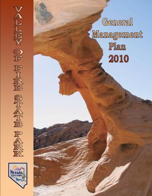
<strong>Valley</strong> <strong>of</strong> <strong>Fire</strong> <strong>State</strong> Park <strong>of</strong>fers some <strong>of</strong> the most unique natural land forms in the state <strong>of</strong><br />
<strong>Nevada</strong>. <strong>Valley</strong> <strong>of</strong> <strong>Fire</strong> is one <strong>of</strong> <strong>Nevada</strong>'s oldest and the largest state park, dedicated in 1934.<br />
The valley derives its name from the red sandstone formations and the stark beauty <strong>of</strong> the<br />
Mojave Desert. Ancient trees and early man are represented throughout the park by areas <strong>of</strong><br />
petrified wood and 3,000 year-old Indian petroglyphs.<br />
A. PURPOSE OF PLAN AMENDMENT<br />
1. Purpose<br />
The purpose <strong>of</strong> this plan amendment is to update the 1990 long-range management plan<br />
for <strong>Valley</strong> <strong>of</strong> <strong>Fire</strong> <strong>State</strong> Park. The plan begins with an introduction to the document and<br />
the park in Chapter 1. Chapter 2 discusses regional influences which directly and<br />
indirectly affect the park. Chapter 3 describes the park’s natural and cultural resources,<br />
including existing facilities and description <strong>of</strong> uses. Chapter 4 summarizes the planning<br />
process and the resulting plan.<br />
2. Planning Process<br />
The current <strong>Valley</strong> <strong>of</strong> <strong>Fire</strong> planning process encompasses work by the <strong>Nevada</strong> Division<br />
<strong>of</strong> <strong>State</strong> <strong>Parks</strong> (NDSP), University <strong>of</strong> <strong>Nevada</strong>, Las Vegas (UNLV), partnering agencies,<br />
technical assistance from the National Park Service River, Trails and Conservation<br />
Assistance (RTCA) Program, and input from the public from 2007-2009. Funding was<br />
provided by the <strong>Nevada</strong> Division <strong>of</strong> <strong>State</strong> <strong>Parks</strong> and from the Land and Water<br />
Conservation Fund administered by the National Park Service. Details <strong>of</strong> the process can<br />
be found in Chapter 4.<br />
a. Past Plans<br />
Past plans addressing visual integrity and environmental sensitivity, recreation<br />
facilities and other issues were reviewed and used in identifying preliminary<br />
issues to be addressed during the planning effort. These plans included:<br />
<strong>Valley</strong> <strong>of</strong> <strong>Fire</strong> <strong>State</strong> Park Master Plan (NDSP, 1990)<br />
<strong>Nevada</strong>’s <strong>State</strong>wide Comprehensive Outdoor Recreation Plan (SCORP) –<br />
Assessment and Policy Plan (NDSP, 2003)<br />
<strong>Nevada</strong> <strong>State</strong> Recreational Trails Plan (<strong>Nevada</strong> Division <strong>of</strong> <strong>State</strong> <strong>Parks</strong><br />
Planning and Development Section, 2005)<br />
Clark County, Multiple Species Habitat Conservation Plan (2000)<br />
BLM Logandale Trails Monitoring Plan (2007)<br />
BLM Integrated Resource and Recreation Area Management Plan <strong>of</strong> the<br />
Logandale Trails System (2007)<br />
<strong>Valley</strong> <strong>of</strong> <strong>Fire</strong> <strong>GMP</strong>, <strong>2010</strong> <strong>Page</strong> 8 <strong>of</strong> <strong>61</strong>
Splendor Among the Rocks-Archeological Paper #4, Volumes 1 and 2, The<br />
Community College <strong>of</strong> Southern <strong>Nevada</strong> Field School, Dept. or Human<br />
Behavior, Dr. Devin Rafferty (July, 2004)<br />
NDOW <strong>State</strong> Action Plan (2005)<br />
Moapa <strong>Valley</strong> Open Space Plan; Clark County, NV (In progress)<br />
Moapa <strong>Valley</strong> Trails Study; Clark County, NV (In progress)<br />
Northeast Clark County Land Use Plan (2006)<br />
Moapa <strong>Valley</strong> Master Plan; <strong>Parks</strong> and Recreation, 20-Year Plan (2007)<br />
Lake Mead Mgmt. Plan (2002); General Mgmt. Plan/EA (Sept. 2005)<br />
b. Planning Team and Key Stakeholders<br />
Several people were instrumental in the gathering <strong>of</strong> information and the<br />
writing <strong>of</strong> the plan. Others were important in the issue identification and<br />
alternatives development meetings.<br />
1. Jenny Scanland, NDSP, <strong>Parks</strong> and Recreation Program Manager<br />
2. Deborah Reardon, National Park Service, Rivers, Trails and<br />
Conservation Assistance Program<br />
3. Jim Hammons, NDSP, <strong>Valley</strong> <strong>of</strong> <strong>Fire</strong> Supervisor<br />
4. Russ Dapsauski and Terry Hansen, NDSP, Southern Regional<br />
Managers<br />
5. Elise McAllister, Partners in Conservation<br />
6. Marilyn Peterson, Bureau <strong>of</strong> Land Management, Recreation Planner<br />
7. Jim Holland, National Park Service, Lake Mead National Recreation<br />
Area<br />
8. Matt Lacroix, Clark County Liaison to Moapa <strong>Valley</strong><br />
9. J. Steve Weaver, NDSP, Deputy Administrator<br />
10. Dr. Kevin Rafferty, Department <strong>of</strong> Human Behavior, College <strong>of</strong><br />
Southern <strong>Nevada</strong><br />
B. PARK SETTING<br />
1. Description and Location<br />
a. Description <strong>of</strong> Park and Location<br />
<strong>Valley</strong> <strong>of</strong> <strong>Fire</strong> <strong>State</strong> Park is located approximately six miles west <strong>of</strong> the northern<br />
arm <strong>of</strong> Lake Mead and 55 miles northeast <strong>of</strong> Las Vegas. It is reached via<br />
Interstate 15 and <strong>State</strong> Highway 169. The park currently encompasses 42,059.48<br />
acres (Certified by <strong>State</strong> Lands, 2009). <strong>State</strong> Highway 169 <strong>of</strong>fers access into the<br />
park at its east and west boundaries. (Figure 1.1; Park Location Map).<br />
<strong>Valley</strong> <strong>of</strong> <strong>Fire</strong> <strong>GMP</strong>, <strong>2010</strong> <strong>Page</strong> 9 <strong>of</strong> <strong>61</strong>
Developed facilities include family and group picnic areas, two<br />
campgrounds, trails, several vista/overlooks and rest areas. Also provided<br />
is a staffed visitor center with <strong>of</strong>fices, staff residences and maintenance<br />
facility. There are also memorial/historic markers, and interpretive sites<br />
for petroglyphs and petrified wood displays. Details <strong>of</strong> facilities provided<br />
are in Chapter 3.<br />
Figure 1.1 Park Location<br />
b. Physical setting <strong>of</strong> the area<br />
The park is situated in the valley created by the North Muddy Mountains to the<br />
west and Muddy Mountains to the south. The Moapa <strong>Valley</strong> lies to the northeast<br />
and the Overton Arm <strong>of</strong> Lake Mead to the east. The valley along with the<br />
surrounding mountains is sparsely vegetated and arid in character. The park <strong>of</strong>fers<br />
a wide variety <strong>of</strong> natural and cultural resources for visitors. The primary and<br />
most striking features <strong>of</strong> the park are the red sandstone formations found<br />
throughout the site. These formations and their color provide interesting contrast<br />
to the surrounding desert. In addition to these naturally carved formations, the<br />
park also has an extensive number <strong>of</strong> petroglyphs. The park's isolation adds to its<br />
uniqueness.<br />
c. Property Ownership<br />
Lands administered by the U.S. Bureau <strong>of</strong> Land Management border the park on<br />
the west, north and south. Lake Mead National Recreation Area, administered by<br />
the National Park Service, lies directly east <strong>of</strong> the park. The park is also bordered<br />
by lands managed by the Bureau <strong>of</strong> Reclamation, Bureau <strong>of</strong> Lands Management<br />
and private property owners. (Appendix 1.1 Land Ownership Map) Since 1980,<br />
<strong>Valley</strong> <strong>of</strong> <strong>Fire</strong> <strong>GMP</strong>, <strong>2010</strong> <strong>Page</strong> 10 <strong>of</strong> <strong>61</strong>
the park has grown to encompass over 35,300 acres. (Appendix 1.2 History <strong>of</strong><br />
Acquisition)<br />
2. Legislation and Policy<br />
a. Legislated Goal<br />
The <strong>Nevada</strong> Division <strong>of</strong> <strong>State</strong> <strong>Parks</strong> (Division) is one <strong>of</strong> many agencies<br />
within the Department <strong>of</strong> Conservation and Natural Resources. The<br />
Division is directed by legislative intent to: ―acquire, protect, develop and<br />
interpret a well balanced system <strong>of</strong> areas <strong>of</strong> outstanding scenic,<br />
recreational, scientific and historical importance for the inspiration, use<br />
and enjoyment <strong>of</strong> the People <strong>of</strong> the <strong>State</strong> <strong>of</strong> <strong>Nevada</strong> and that such areas<br />
shall be held in trust as irreplaceable portions <strong>of</strong> <strong>Nevada</strong>’s natural and<br />
historic heritage‖ (NRS 407.013).<br />
b. NV Administrative Code; Park Specific<br />
NAC 407.350 <strong>Valley</strong> <strong>of</strong> <strong>Fire</strong> <strong>State</strong> Park. (NRS 407.0475, 407.065)<br />
1. Within the <strong>Valley</strong> <strong>of</strong> <strong>Fire</strong> <strong>State</strong> Park, a person shall not climb a rock<br />
formation or otherwise engage in rock climbing except in an area<br />
designated for such climbing by the Supervisor <strong>of</strong> the Park.<br />
2. A person climbing in such an area:<br />
(a) May use ropes, carabineers, web belts, webbing and cushioning<br />
materials.<br />
(b) Shall not use any pitons, chocks, or other such climbing devices or any<br />
magnesium carbonate chalk in climbing unless:<br />
(1) The person is engaged in emergency rescue operations; or<br />
(2) The Supervisor <strong>of</strong> the Park approves the use <strong>of</strong> such devices or chalk.<br />
[Div. <strong>of</strong> St. <strong>Parks</strong>, eff. 1-2-80]—(NAC A 8-17-82; 12-31-85, eff. 1-1-86;<br />
11-12-93; R118-01, 12-17-2001; R153-03, 1-16-2004; R149-05, 5-4-<br />
2006)<br />
c. Land and Water Conservation Fund Protection<br />
All <strong>of</strong> the <strong>State</strong> <strong>of</strong> <strong>Nevada</strong> owned acreage within the boundary <strong>of</strong> the Park<br />
is under the protection <strong>of</strong> the Land and Water Conservation Fund (LWCF)<br />
6(f)3 provision. By federal law, property acquired or developed with<br />
LWCF assistance shall be retained and used for public outdoor recreation<br />
uses only. Therefore, no portion <strong>of</strong> the park may be wholly or partly<br />
converted to other than public outdoor recreation uses without the<br />
approval <strong>of</strong> the National Park Service Regional Director pursuant to<br />
Section 6(f)3 <strong>of</strong> the LWCF Act and 36 CFR part 59. All facilities must be<br />
compatible and support outdoor recreation.<br />
<strong>Valley</strong> <strong>of</strong> <strong>Fire</strong> <strong>GMP</strong>, <strong>2010</strong> <strong>Page</strong> 11 <strong>of</strong> <strong>61</strong>
3. 1990 Goals/Objectives<br />
This planning process will address the applicability <strong>of</strong> the 1990 goals and<br />
objectives from the past plan and update them to address the demands and<br />
needs <strong>of</strong> recreation while continuing to protect the park’s unique<br />
resources. The timeframe for this plan is 15 years, or from <strong>2010</strong> to 2025.<br />
Below are the goals and objectives for the park that are being considered<br />
for revision:<br />
a. 1990 Plan Concept<br />
The 1990 plan described the park concept as follows: <strong>Valley</strong> <strong>of</strong> <strong>Fire</strong> <strong>State</strong><br />
Park <strong>of</strong>fers some <strong>of</strong> the most unique natural land forms in the state <strong>of</strong><br />
<strong>Nevada</strong>. The protection <strong>of</strong> these resources is the primary objective <strong>of</strong> <strong>State</strong><br />
<strong>Parks</strong>.<br />
Along with resource conservation, in 1990, <strong>State</strong> <strong>Parks</strong> was looking<br />
into ways to increase visitation and provide greater use <strong>of</strong> the<br />
resources through increased public access.<br />
Resource conservation and increased park access were both elements<br />
which were to be managed at an appropriate level to provide for a<br />
broad range <strong>of</strong> recreational activities from the most passive to the<br />
more demanding activities <strong>of</strong> primitive camping and climbing.<br />
The 1990 plan stated that access was the key to providing these<br />
activities to the broadest range <strong>of</strong> age groups and physical abilities.<br />
Paved access was to be provided to park staff and the public; in order<br />
to provide easier and more efficient means <strong>of</strong> patrolling and managing<br />
the park.<br />
The new Plan Concept was developed by staff and the public in<br />
December, 2009. This park concept consists <strong>of</strong> five mission statements<br />
that will direct the park’s management for the next 15 years or until<br />
amended or revised.<br />
Park Concept 2009:<br />
The <strong>Valley</strong> <strong>of</strong> <strong>Fire</strong> <strong>State</strong> Park <strong>of</strong>fers some <strong>of</strong> the most unique<br />
natural landforms, archeological and paleontological resources and<br />
scenic values in the state <strong>of</strong> <strong>Nevada</strong>.<br />
Sensitive areas in this desert ecosystem are protected for future<br />
generations while allowing for compatible recreational use; public<br />
access is controlled through designated trails, roadways and<br />
recreation areas.<br />
<strong>Valley</strong> <strong>of</strong> <strong>Fire</strong> <strong>GMP</strong>, <strong>2010</strong> <strong>Page</strong> 12 <strong>of</strong> <strong>61</strong>
The Park provides extensive interpretation and educational<br />
programs and amenities with an emphasis on engaging youth.<br />
<strong>Valley</strong> <strong>of</strong> <strong>Fire</strong> <strong>State</strong> Park will continue to be an outdoor classroom<br />
through research partnerships that support the conservation and<br />
protection <strong>of</strong> resources.<br />
All facilities in the park, including signs and interpretation, are<br />
designed to be unobtrusive, visually compatible with the natural<br />
landscape and consistent with scenic highway aesthetic standards.<br />
b. 1990 Natural/Cultural Resource Objectives<br />
<br />
<br />
<br />
<br />
All natural components <strong>of</strong> the park (flora, fauna, soils and geology)<br />
were to be identified so that they may be protected, interpreted and<br />
managed adequately.<br />
Endangered, rare or protected species were to be identified, located<br />
and protected as befitted the situation.<br />
Cultural resources were to be protected and maintained in an<br />
appropriate manner; visitor safety and convenience were to be kept<br />
foremost when considering maintenance projects on historic structures.<br />
Since the site contains major works <strong>of</strong> prehistoric petroglyphs, great<br />
care was to be taken in exhibiting, interpreting, and protecting these<br />
resources for future generations.<br />
4. Major Current Issues<br />
a. Park Specific Issues<br />
Fragile Desert Ecosystem: <strong>Valley</strong> <strong>of</strong> <strong>Fire</strong> at first glance would appear to<br />
be a barren desolate desert with little or no life. In fact, <strong>Valley</strong> <strong>of</strong> <strong>Fire</strong> is a<br />
very fragile environment where hundreds <strong>of</strong> species <strong>of</strong> flora and fauna<br />
live. Many <strong>of</strong> them are highly specialized to contend with the harsh desert<br />
environment. As such, minor alterations to the ecosystem could have<br />
dramatic effects. The cutting <strong>of</strong> indiscriminate 4WD trails and hiking,<br />
equestrian or biking social trails, can produce scars on the landscape that<br />
may take tens or even hundreds <strong>of</strong> years to erase.<br />
The unique geology and erosion which created the colorful geologic<br />
formations <strong>of</strong> the park is an ongoing process. Consequently, careful<br />
consideration must be given to the location <strong>of</strong> facilities to prevent scenic<br />
degradation or more practical considerations such as damage from<br />
flooding.<br />
<strong>Valley</strong> <strong>of</strong> <strong>Fire</strong> <strong>GMP</strong>, <strong>2010</strong> <strong>Page</strong> 13 <strong>of</strong> <strong>61</strong>
Human activities have impacted the environment <strong>of</strong> the park throughout<br />
its history. To date, the impact <strong>of</strong> man on the valley has left the park with<br />
unique rock carvings or petroglyphs. The site has been historically a site<br />
for hunting by many generations. The remote location and absence <strong>of</strong><br />
potable surface water has helped to protect the valley from incursions by<br />
modern man.<br />
1) Uncontrolled Access: Major concerns expressed during<br />
preparation <strong>of</strong> the 1990 plan and that continue today are the lack<br />
<strong>of</strong> access to the formations and areas in the northern portion <strong>of</strong> the<br />
park. Some participants wanted to see wide open access to the<br />
park from all points <strong>of</strong> entry. Logistically this seemed much too<br />
difficult from the aspect <strong>of</strong> staff resources available in 1990 and it<br />
still does today. The past plan recommended that a second fee<br />
booth be installed on the eastern entrance road in order to increase<br />
public contact and provide additional information and educational<br />
materials to the public. This has not occurred yet.<br />
2) Off-road vehicle (OHV): Unauthorized use is resulting in<br />
resource degradation in the north half <strong>of</strong> the park. The Park<br />
boundary marking is not comprehensive and the adjacent<br />
Logandale OHV trail system passes near and through the park in<br />
several places. Increased educational and directional signage is<br />
needed to direct the users to designated trails. The problem <strong>of</strong><br />
unauthorized public use is also enhanced by the number <strong>of</strong> access<br />
points to the park. The park has not been able to provide control<br />
<strong>of</strong> all access points and therefore gain control <strong>of</strong> undesirable park<br />
use. The lack <strong>of</strong> funding for operations in the park, education and<br />
interpretational signage has had to be utilized to the fullest extent<br />
affordable to control and redirect motorized use and reduce<br />
resource damage.<br />
3) Flora and Fauna, and their Habitat: The Multiple Species<br />
Habitat Conservation Plan for this region includes the VOF and<br />
the park is a partner in those efforts. Inventory <strong>of</strong> Threatened,<br />
Endangered and <strong>State</strong> Listed Species and habitats needs to occur<br />
in the park to aid management in protection <strong>of</strong> these species and<br />
their habitats. The Division utilizes our partner agency Natural<br />
Heritage to help identify known habitats and species presence.<br />
4) Vandalism <strong>of</strong> Petroglyphs and Petrified Wood Sites: Vandalism<br />
is a problem within the park and the fragile nature <strong>of</strong> these<br />
resources and their locations make them difficult to protect.<br />
Climbing within the park is addressed through NAC 407.350 (see<br />
previous section 2.b.) and prohibits these activities from leaving<br />
lasting effects on the park’s formations. Inventory <strong>of</strong><br />
paleontological and archaeological sites has occurred and<br />
mitigation as well as protective interpretive panels and facilities<br />
<strong>Valley</strong> <strong>of</strong> <strong>Fire</strong> <strong>GMP</strong>, <strong>2010</strong> <strong>Page</strong> 14 <strong>of</strong> <strong>61</strong>
are in place to protect known sites. However, fencing is not<br />
adequate to stop vandals from removing the petrified wood from<br />
the park at this time and theft occurred in 2007.<br />
5) Special Uses Movie Sets: The Park has been the site <strong>of</strong> many<br />
motion pictures, music videos and commercials. Problems have<br />
occurred which have resulted in the destruction and scarring <strong>of</strong> the<br />
landscape. Most <strong>of</strong> these problems have occurred due to<br />
carelessness and not through malicious activities. Additionally,<br />
there is a greater need for staging areas for movies and large<br />
events.<br />
6) Special Uses Weddings: The Park is under great demand for<br />
special use permits for weddings. The number <strong>of</strong> requests is over<br />
that which current staff can manage while still managing the rest<br />
<strong>of</strong> the park users, maintenance and administration.<br />
7) Trails: Due to the lack <strong>of</strong> natural water availability, extreme heat<br />
during the summers and the unsuitable nature <strong>of</strong> the soils, most <strong>of</strong><br />
the trails in the park are fairly short distance. The unstable nature<br />
<strong>of</strong> the soils does not allow for sustainable trails that are accessible<br />
in most areas.<br />
8) Day and Overnight Use: Conflicts have arisen in the past<br />
between car campers and RV campers related to noise and<br />
generators. The latest campground installation (2008) should help<br />
as it provides a RV hook-up section that is separated from the rest<br />
<strong>of</strong> the campsites. There is also a need to renovate the current<br />
group picnic facilities and group camping facilities.<br />
II.<br />
REGIONAL INFLUENCES<br />
A. PARK HISTORY<br />
1. History <strong>of</strong> the Area<br />
Recorded history at <strong>Valley</strong> <strong>of</strong> <strong>Fire</strong> began in 1826 when the first Europeans,<br />
mostly fur trappers, entered the valley. One <strong>of</strong> the first explorers to cross the<br />
valley was Jedediah Smith, a well known mountain man. Smith's route, which<br />
followed the Virgin River, brought travelers from Santa Fe westward. Another<br />
pioneer trail which passed near the park was known as the Spanish Trail and was<br />
actively used during the 1830's and 1840's. The Spanish Trail passes to the west<br />
<strong>of</strong> the park.<br />
The treaty <strong>of</strong> Guadalupe Hidalgo ceded land from Mexico to the United <strong>State</strong>s in<br />
1848 and this land treaty encompassed all <strong>of</strong> southern <strong>Nevada</strong>, including the<br />
<strong>Valley</strong> <strong>of</strong> <strong>Fire</strong>.<br />
<strong>Valley</strong> <strong>of</strong> <strong>Fire</strong> <strong>GMP</strong>, <strong>2010</strong> <strong>Page</strong> 15 <strong>of</strong> <strong>61</strong>
Through the 1840's the Spanish Trail, also known as the Mormon Road, became a<br />
main route from Salt Lake City to southern California. The use <strong>of</strong> trails by white<br />
immigrants was a traumatic shock to the Paiute people who lived in the area.<br />
Occasional hostilities broke out between the two cultures concerning ownership<br />
<strong>of</strong> land and animals. Farming, which brought with it land ownership, slowly<br />
displaced the Native American population. Mormon colonists started to establish<br />
settlements along the Muddy and Virgin Rivers, adjacent to the park.<br />
One <strong>of</strong> the better known legends which involves the park, concerns a Paiute<br />
Indian by the name <strong>of</strong> Mouse. Mouse was considered a renegade by the white<br />
settlers and an outcast by his own tribe. As with many legends, the facts are not<br />
always clear or agreed upon. According to one story, Mouse was employed by<br />
George Bonelli, a merchant and rancher as a hand on a ferry at Bonelli's Landing.<br />
Mouse's trouble began when he shot up an Indian camp while drinking one<br />
evening. Mouse was locked up and later ferried across the river and left in<br />
Arizona. He then, reportedly, killed two white prospectors and fled to the <strong>Valley</strong><br />
<strong>of</strong> <strong>Fire</strong>.<br />
Several searches were conducted to locate him and bring him to justice. Mouse's<br />
hideout within the rugged landscape <strong>of</strong> <strong>Valley</strong> <strong>of</strong> <strong>Fire</strong> made him difficult to track.<br />
From his hideout, Mouse made several forays into the settlement to steal goods<br />
and materials. The search parties were always puzzled how Mouse could live<br />
within the valley since no running water was available. However, Mouse knew<br />
the valley very well and discovered a natural depression within the rocks which<br />
would hold rain water for months at a time. This depression is known today as<br />
"Mouse's Tank" and is a popular attraction within the park.<br />
Mouse was finally found on July 11, 1897 by a posse which ordered him to<br />
surrender near Muddy Spring. Mouse did not surrender and instead had an hour<br />
long running gun fight with his pursuers before finally being shot.<br />
The Moapa Indian Reservation was created in 1872 along the Muddy River. The<br />
reservation contains approximately 72,000 acres near the park. As time<br />
progressed, the river valley became more intensively farmed with the introduction<br />
<strong>of</strong> modern irrigation and fertilizers.<br />
In addition to farming, mining for minerals such as gypsum, magnetite, silica,<br />
borates and lithium took place in the area. The valley did not contain large<br />
mineral deposits and was not intensively mined. The mines that used to operate in<br />
the park are closed and rehabilitated as <strong>of</strong> 2007.<br />
The <strong>Valley</strong> <strong>of</strong> <strong>Fire</strong> became a wagon road cut<strong>of</strong>f to Las Vegas in the latter part <strong>of</strong><br />
the 19th century and early 20th century. In 1914 Clark County built a dirt road<br />
through the <strong>Valley</strong> to serve as part <strong>of</strong> the Arrowhead Trail between Salt Lake City<br />
and Los Angeles. The route was abandoned in 1925 when a more northerly route<br />
<strong>Valley</strong> <strong>of</strong> <strong>Fire</strong> <strong>GMP</strong>, <strong>2010</strong> <strong>Page</strong> 16 <strong>of</strong> <strong>61</strong>
was established along present-day Interstate 15. Before the trail was abandoned,<br />
an <strong>of</strong>ficial <strong>of</strong> the American Automobile Association named the <strong>Valley</strong> after<br />
seeing it near sunset ablaze with red-orange color.<br />
Beginning in 2007, the neighboring Lake Mead National Recreation Area began<br />
to lose significant amounts <strong>of</strong> water due to drought. The impacts <strong>of</strong> the lowering<br />
<strong>of</strong> the lake on the use <strong>of</strong> that NRA has not been measured yet in terms <strong>of</strong> it's<br />
impact on the <strong>Valley</strong> <strong>of</strong> <strong>Fire</strong> <strong>State</strong> Park. The lake remains at record low levels and<br />
current use is reflecting those low levels.<br />
2. History <strong>of</strong> <strong>Valley</strong> <strong>of</strong> <strong>Fire</strong> <strong>State</strong> Park<br />
In 1914, Clark Co. helped in the building <strong>of</strong> a rough road through the valley to<br />
serve a segment <strong>of</strong> the Arrowhead Trail. In the 1920's, Governor James<br />
Scrugham recognized the beauty <strong>of</strong> the <strong>Valley</strong> and requested transfer <strong>of</strong> the land<br />
from federal public domain to the state. <strong>Valley</strong> <strong>of</strong> <strong>Fire</strong> was <strong>of</strong>ficially dedicated as<br />
<strong>Nevada</strong>'s first state park in 1934. The first major construction within the park<br />
occurred between 1933 and 1935. This construction included a road and the<br />
"Cabins" built by the Civilian Conservation Corps. The "Cabins", small stone<br />
structures, were built to accommodate overnight travelers. The CCC was under<br />
the direction <strong>of</strong> Colonel Thomas W. Miller <strong>of</strong> Caliente, <strong>Nevada</strong> and continued for<br />
several years.<br />
In the decades that followed, legislative appropriations were very meager with no<br />
personnel available for maintenance. Funds for the park were cut<strong>of</strong>f entirely<br />
during World War II. The Baker Act, passed in 1940, eliminated the <strong>Valley</strong> <strong>of</strong><br />
<strong>Fire</strong> from the <strong>State</strong> park system, ironically based on the premise that the park was<br />
too isolated and inaccessible and had no recreational value.<br />
Several prominent <strong>Nevada</strong>ns opposed the closing, including former Governor<br />
Scrugham, Colonel Miller and the Perkins family. As a result <strong>of</strong> this vocal<br />
opposition, the Baker Act was repealed around 1955. During this period,<br />
Governor Charles H. Russell stimulated the park system by appointing a new<br />
commission which elected Colonel Miller as chairman. The colonel's appearance<br />
at a hearing <strong>of</strong> the 1955 legislature led to a biennium appropriation <strong>of</strong> $4,000 for<br />
the commission. <strong>Valley</strong> <strong>of</strong> <strong>Fire</strong>, soon after, was given its first superintendent and<br />
ranger. An <strong>of</strong>fice was leased and a truck was purchased for the park. The<br />
"Cabins" were allocated $500 for improving the structure.<br />
Establishment <strong>of</strong> the modern <strong>Valley</strong> <strong>of</strong> <strong>Fire</strong> <strong>State</strong> Park began with the addition <strong>of</strong><br />
facilities such as campgrounds and a Visitor Information Center in the late 1960's.<br />
(1969,Wirth; Park System Plan, 1997) From 1990 to 2008 many improvements<br />
have been made in the park. Trails have been designated and signed, petroglyphs<br />
have been made more accessible with stairs and protected from visitors touching<br />
or scraping the sites. Interpretive programs have been developed and implemented<br />
as well. The White Domes road was paved and Arch Rock and Atlatl Rock<br />
<strong>Valley</strong> <strong>of</strong> <strong>Fire</strong> <strong>GMP</strong>, <strong>2010</strong> <strong>Page</strong> 17 <strong>of</strong> <strong>61</strong>
campgrounds were developed. A new campground loop at Atlatl Rock was<br />
installed in 2008 which provides additional sites that have full RV hookups. Many<br />
<strong>of</strong> the toilets were upgraded in the 90’s and shade structures at the group sites<br />
were improved. The most current development project is that <strong>of</strong> new <strong>of</strong>fices, staff<br />
living quarters and an upgraded Visitors Center, which is in progress.<br />
The Park has undergone significant changes in landownership through the years.<br />
Prior to 1973 the <strong>Valley</strong> <strong>of</strong> <strong>Fire</strong> <strong>State</strong> Park included approximately 34,000 acres<br />
and included those lands which make up the main core <strong>of</strong> the park. In 1973 a<br />
Patent was applied for through the Bureau <strong>of</strong> Land Management, Recreation and<br />
Public Purpose Lease program for acreage on the north backcountry section and a<br />
few acres on the east side <strong>of</strong> the park. The acreages in those applications changed<br />
many times as the process was completed. In 2006 an additional 420 acre inholding<br />
was acquired in the northern section <strong>of</strong> the Park called the White-Gro<br />
mine. The current total acreage <strong>of</strong> park land is 42,059.48.<br />
B. DEMOGRAPHICS<br />
1. Historic<br />
The <strong>Valley</strong> <strong>of</strong> <strong>Fire</strong> derives its name from red sandstone formations, formed from<br />
great shifting sand dunes during the age <strong>of</strong> dinosaurs, 150 million years ago.<br />
Complex uplifting and faulting <strong>of</strong> the region, followed by extensive erosion, have<br />
created the present landscape. Prehistoric users <strong>of</strong> the <strong>Valley</strong> <strong>of</strong> <strong>Fire</strong> included the<br />
Basket Maker people and later the Anasazi Pueblo farmers from the nearby fertile<br />
Moapa <strong>Valley</strong>. The approximate span <strong>of</strong> occupation has been dated from 300 B.C.<br />
to 1150 A.D. Their visits probably involved hunting, food gathering, and religious<br />
ceremonies, although scarcity <strong>of</strong> water would have limited the length <strong>of</strong> their stay.<br />
The growth around <strong>Valley</strong> <strong>of</strong> <strong>Fire</strong> <strong>State</strong> Park was never explosive but did increase<br />
through the settlement <strong>of</strong> the farms and ranches near Overton and the Moapa<br />
<strong>Valley</strong>. The greatest impact <strong>of</strong> population on the <strong>Valley</strong> <strong>of</strong> <strong>Fire</strong> has been and still<br />
is from the urban center <strong>of</strong> Las Vegas.<br />
2. Existing/Projected<br />
The park is situated in the valley created by the North Muddy Mountains to the<br />
west and Muddy Mountains to the south. The Moapa <strong>Valley</strong> lies to the northwest<br />
and the Overton Arm <strong>of</strong> Lake Mead to the east. The valley along with the<br />
surrounding mountains is sparsely vegetated and arid in character. The park <strong>of</strong>fers<br />
a wide variety <strong>of</strong> natural and cultural resources for visitors. The primary and<br />
most striking features <strong>of</strong> the park are the red sandstone formations found<br />
throughout the site. These formations and their color provide interesting contrast<br />
to the surrounding desert. In addition to these naturally carved formations, the<br />
park also has an extensive number <strong>of</strong> petroglyphs. The park's isolation also helps<br />
give the park its unique character<br />
<strong>Valley</strong> <strong>of</strong> <strong>Fire</strong> <strong>GMP</strong>, <strong>2010</strong> <strong>Page</strong> 18 <strong>of</strong> <strong>61</strong>
a. Clark County Demographics<br />
Demographics and socioeconomic condition for Clark County, Las Vegas and<br />
the <strong>State</strong> <strong>of</strong> <strong>Nevada</strong> are in flux during this planning period due to a significant<br />
national economic recession.<br />
Average Annual Population Growth 1990-2008 5.22% (declining)<br />
Source: Clark County Annual Population Estimates<br />
Average Monthly In-Migration - 2008 -2,396 (declining)<br />
Source: Clark County Comprehensive Planning / NV Bureau <strong>of</strong> Health<br />
Planning & Statistics Preliminary '07 Annual Birth & Death Rates<br />
Annual Job Growth Rate Las Vegas- - 4 . 5 % (declining)<br />
Unemployment Rate - Las Vegas-Paradise MSA 10.1% (increasing)<br />
Source: <strong>Nevada</strong> Dept. <strong>of</strong> Employment, Training & Rehabilitation (2/09)<br />
As <strong>of</strong> the 2000 census, approximately 1.4 million people resided in the county.<br />
Population estimates by Clark County for 2008 were 1,986,146 and growing.<br />
However, due to the economic recession, Clark County and Las Vegas have<br />
experienced a large number <strong>of</strong> home foreclosures and job losses. This has resulted<br />
in a drop in population. University <strong>of</strong> <strong>Nevada</strong>, Reno economist Tom Cargill<br />
estimated that there would be a declining population in Clark County due to the<br />
recession in <strong>2010</strong>.<br />
However, this is disputed by the Clark County 2009 Comprehensive planning<br />
Demographer estimates which show increases in population through 2035.<br />
Described below are the results <strong>of</strong> the 2005 census estimates, combined<br />
with 2006 and 2009 data as provided by the County and <strong>State</strong>.<br />
The racial makeup <strong>of</strong> the county in 2005 was 54.5% Caucasian Non<br />
Hispanic, 26.1% Hispanic, 10.1% Black or African American, 1.0%<br />
Native American Indian, 6.7% Asian, 0.6% Pacific Islander, and 2.8%<br />
from two or more races (Figure 2.1 Clark County Racial Make Up).<br />
<strong>Valley</strong> <strong>of</strong> <strong>Fire</strong> <strong>GMP</strong>, <strong>2010</strong> <strong>Page</strong> 19 <strong>of</strong> <strong>61</strong>
Clark County Racial Demographics<br />
Caucasian Non-<br />
Hispanic<br />
Hispanic<br />
African American<br />
Nativ e American<br />
Indian<br />
Asian<br />
Pacific Islander<br />
Two or More<br />
Figure 2.1 Clark County Racial Makeup<br />
Minorities make up almost half <strong>of</strong> Clark County’s population.<br />
(US Census, 2005)<br />
By 2005, there were 637,740 households <strong>of</strong> which 414,377 were family<br />
households (Figure 2.2 Clark County Household Demographics). Of the<br />
family households, 47% had children under the age <strong>of</strong> 18 living with them.<br />
There were 122,383 family households comprised <strong>of</strong> single parent<br />
households, with approximately two times as many single female parents<br />
as male parents. There were 171,314 households with individuals living<br />
alone. There were 132,5<strong>61</strong> households with one or more people 65 years<br />
<strong>of</strong> age or older. The average household size was 2.65 and the average<br />
family size was 3.25 (US Census, 2005).<br />
Clark County Household Demographics<br />
Married-couple<br />
families<br />
Single male<br />
families<br />
Single female<br />
families<br />
Non-family liv ing<br />
alone<br />
Other non-family<br />
households<br />
(US Census, 2005)<br />
Figure 2.2 Clark County Household Demographics<br />
There is a large family community and significant percentage <strong>of</strong> individuals living alone.<br />
<strong>Valley</strong> <strong>of</strong> <strong>Fire</strong> <strong>GMP</strong>, <strong>2010</strong> <strong>Page</strong> 20 <strong>of</strong> <strong>61</strong>
The age demographics <strong>of</strong> Clark County indicate that 26% <strong>of</strong> the<br />
population is under the age <strong>of</strong> 18, 9% from 18 to 24, 31% from 25 to 44,<br />
23% from 45 to 64, and 11% who were 65 years <strong>of</strong> age or older (Figure<br />
2.3 Clark County Age Demographics). The median age was 34.4 years.<br />
Clark County Age Demographics<br />
Under 18<br />
18-24<br />
25-44<br />
45-64<br />
Ov er 65<br />
Figure 2.3 Clark County Age Demographics<br />
(US Census, 2005)<br />
There is a fairly even distribution <strong>of</strong> age groups with a slight lean towards<br />
children and 25-44 yrs which supports the large 'family' demographics<br />
below.<br />
b. Las Vegas Demographics<br />
Las Vegas is a census-designated place (CDP) located in Clark County,<br />
<strong>Nevada</strong>. The demographics <strong>of</strong> the city <strong>of</strong> Las Vegas represent urban Clark<br />
County.<br />
Las Vegas is located at 36°10'34" North, 115°8'13" West (39.176, -<br />
115.137) (Wikipedia, 2007). According to the United <strong>State</strong>s Census<br />
Bureau, the CDP has a total area <strong>of</strong> 340.0 km² (131.3 mi²). As <strong>of</strong> the<br />
census <strong>of</strong> 2000, there were 478,434 people, 176,750 households, and<br />
117,538 families residing in the city. The population density was<br />
1,630.3/km² (4,222.5/mi²). There were 190,724 housing units at an<br />
average density <strong>of</strong> 649.9/km² (1683.3/mi²) (US Census Bureau, 2000).<br />
The racial makeup <strong>of</strong> Las Vegas in 2005 was very similar to that <strong>of</strong> Clark<br />
County: 52.3% White, 28.5% Hispanic, 11.1% African American, 0.6%<br />
Native American, 4.7% Asian, 0.4% Pacific Islander, 3.0% from two or<br />
more races (US Census Bureau, 2005).<br />
<strong>Valley</strong> <strong>of</strong> <strong>Fire</strong> <strong>GMP</strong>, <strong>2010</strong> <strong>Page</strong> 21 <strong>of</strong> <strong>61</strong>
Las Vegas Household Demographics<br />
Married-couple<br />
families<br />
Single male<br />
families<br />
Single female<br />
families<br />
Non-family liv ing<br />
alone<br />
Other non-family<br />
households<br />
(US Census, 2005)<br />
Figure 2.4 Las Vegas Household Demographics; about a third <strong>of</strong> the households in Las<br />
Vegas are non-family.<br />
There are a slightly smaller proportion <strong>of</strong> families in the City <strong>of</strong> Las Vegas<br />
when compared to the demographics <strong>of</strong> overall Clark County. In 2005,<br />
there were 204,688 households <strong>of</strong> which 132,735 are family households<br />
(Figure 2.4 Las Vegas Household Demographics). Of the family<br />
households, 48% had children under the age <strong>of</strong> 18 living with them. Of<br />
these family households, 41,098 are single parent households with more<br />
than two times as many single female parents as male parents. There were<br />
56,733 households made up <strong>of</strong> individuals living alone. There were 45,667<br />
households with one or more people 65 years <strong>of</strong> age or older. The average<br />
household size was 2.63 and the average family size was 3.26 (US Census,<br />
2005).<br />
<strong>Valley</strong> <strong>of</strong> <strong>Fire</strong> <strong>GMP</strong>, <strong>2010</strong> <strong>Page</strong> 22 <strong>of</strong> <strong>61</strong>
Las Vegas Age Demographics<br />
Under 18<br />
18-24<br />
25-44<br />
45-64<br />
Ov er 65<br />
(US Census, 2005)<br />
Figure 2.5 Las Vegas Age Demographics<br />
In Las Vegas the population was spread out with 27% under the age <strong>of</strong> 18,<br />
8% from 18 to 24, 32% from 25 to 44, 22% from 45 to 64, and 12% who<br />
were 65 years <strong>of</strong> age or older (Figure 2.5 Las Vegas Age Demographics).<br />
Las Vegas demographics show slightly larger percentage <strong>of</strong> people under<br />
the age <strong>of</strong> 18 and over 65 than Clark County. The median age was 34.8<br />
years.<br />
c. Moapa <strong>Valley</strong> Demographics<br />
The City <strong>of</strong> Overton lies just under 20 miles from the park and resides in<br />
the Census Designated Place (CDP) <strong>of</strong> Moapa <strong>Valley</strong>. Census statistics<br />
also include the towns <strong>of</strong> Logandale and Moapa.<br />
As <strong>of</strong> the 2000 census there were 5,784 people, 1,934 households, and<br />
1,525 families residing in the CDP. Clark County’s estimate for 2008 was<br />
7,200.<br />
In 2005, there were 1,934 households out <strong>of</strong> which 38.8% had children<br />
under the age <strong>of</strong> 18 living with them, 69.8% were married couples living<br />
together, 6.5% had a female householder with no husband present, and<br />
21.1% were non-families. 17.8% <strong>of</strong> all households were made up <strong>of</strong><br />
individuals and 10.4% had someone living alone who was 65 years <strong>of</strong> age<br />
or older. The average household size was 2.99 and the average family size<br />
was 3.43.<br />
In the CDP the population was spread out with 33.5% under the age <strong>of</strong> 18,<br />
6.7% from 18 to 24, 23.0% from 25 to 44, 21.6% from 45 to 64, and<br />
<strong>Valley</strong> <strong>of</strong> <strong>Fire</strong> <strong>GMP</strong>, <strong>2010</strong> <strong>Page</strong> 23 <strong>of</strong> <strong>61</strong>
15.2% who were 65 years <strong>of</strong> age or older. The median age was 36 years.<br />
For every 100 females there were 101.7 males. For every 100 females age<br />
18 and over, there were 98.2 males.<br />
The median income for a household in the CDP was $39,942, and the<br />
median income for a family was $47,575. Males had a median income <strong>of</strong><br />
$42,348 versus $26,442 for females. The per capita income for the CDP<br />
was $16,696. About 5.7% <strong>of</strong> families and 6.9% <strong>of</strong> the population were<br />
below the poverty line, including 7.3% <strong>of</strong> those under age 18 and 8.3% <strong>of</strong><br />
those age 65 or over.<br />
The Las Vegas metropolitan region augments the population <strong>of</strong> the Moapa<br />
<strong>Valley</strong> as a bedroom community to Las Vegas. Other future development<br />
in the area such as Coyote Springs to the North appears to be increasing<br />
use <strong>of</strong> <strong>Valley</strong> <strong>of</strong> <strong>Fire</strong> <strong>State</strong> Park by regional and local users.<br />
C. RECREATIONAL DEMAND<br />
1. Effect <strong>of</strong> Population Increases and socioeconomics and Demand<br />
Past rapid development in the Las Vegas, Moapa <strong>Valley</strong> and Clark County in<br />
general increases pressure on all recreation facilities in the region. Increasing<br />
populations raise demand for these facilities at all levels. City and County<br />
recreation providers continue to try to catch up and to keep pace with demand and<br />
use. Residents may apply increasing pressure on the <strong>State</strong> system to meet their<br />
needs.<br />
The recession that began at the end <strong>of</strong> the decade has reminded recreation<br />
providers that recreation areas continue to be in high demand during economic<br />
stress. There is a "stay close to home" need with less folks traveling as far to<br />
recreation due to cost. At this point, due to demand, the <strong>Nevada</strong> Division <strong>of</strong> <strong>State</strong><br />
<strong>Parks</strong> (NDSP) is currently upgrading old facilities and has already added and<br />
upgraded the campgrounds at <strong>Valley</strong> <strong>of</strong> <strong>Fire</strong>. The lack <strong>of</strong> projected funding for the<br />
<strong>State</strong> in the next decade demands that maintenance is critical to our parks. The<br />
increasing proximity <strong>of</strong> Las Vegas development reduces travel time to the Park,<br />
making the park more accessible and increasing demands. International visitation<br />
is also increasing and the park is currently upgrading the visitor's center to help<br />
meet those demands.<br />
A number <strong>of</strong> data sources provide insight into the socioeconomic condition <strong>of</strong><br />
regional residents and park visitors. This information can be used to help<br />
determine the ability <strong>of</strong> regional residents to participate in the full range <strong>of</strong><br />
recreational activities available. The <strong>2010</strong> Census is getting underway and no data<br />
is available at present. The 2005 Census data for Clark County shows a slightly<br />
lower percentage <strong>of</strong> poverty level families and senior citizens than that <strong>of</strong> the rest<br />
<strong>Valley</strong> <strong>of</strong> <strong>Fire</strong> <strong>GMP</strong>, <strong>2010</strong> <strong>Page</strong> 24 <strong>of</strong> <strong>61</strong>
<strong>of</strong> the United <strong>State</strong>s. The population <strong>of</strong> the area leans towards families, and<br />
therefore affordable family and group activities areas are needed. Due to this<br />
demand, <strong>Valley</strong> <strong>of</strong> <strong>Fire</strong> is adding and upgrading camping facilities and other older<br />
facilities. The Park is also upgrading the trail signage and interpretive/education<br />
signage to meet these needs.<br />
The median income for a household in the county was $44,<strong>61</strong>6, and the median<br />
income for a family was $50,485. Males had a median income <strong>of</strong> $35,243 versus<br />
$27,077 for females. The per capita income for the county was $21,885 (U.S.<br />
Census Bureau, 2000).<br />
The U.S. Census Bureau described the national poverty line for 2005 as an<br />
individual income <strong>of</strong> $10,160 or less. A total <strong>of</strong> 10.8% <strong>of</strong> the Clark County<br />
population and 7.9% <strong>of</strong> Clark County families were below the poverty line which<br />
are significantly lower than the national percentages <strong>of</strong> 12.6 and 10.8. 14.1% <strong>of</strong><br />
those under the age <strong>of</strong> 18 and 7.3% <strong>of</strong> those 65 and older in Clark County were<br />
living below the poverty line (U.S. Census Bureau, 2000). According to Clark<br />
County data, the poverty rate in Clark County, <strong>Nevada</strong> has increased by 0.4<br />
percent from the levels reported in the Decennial Census <strong>of</strong> 2000, moving from<br />
10.8 percent to 11.2 percent in 2006.<br />
2. Visitation Characteristics<br />
Overall visitation to all <strong>Nevada</strong> <strong>State</strong> <strong>Parks</strong> has gradually increased between 1990<br />
and 2008 with relatively smaller fluctuations. Following its peak <strong>of</strong> 3,472,248<br />
visitors in 2000, overall visitation leveled <strong>of</strong>f in the last few years at<br />
approximately 3,200,000 visitors, which is larger than the mean <strong>of</strong> 3,165,657.<br />
3. Activity Preferences and Demand<br />
The 2009 NDSP <strong>State</strong>wide Visitor Survey Report listed the following outdoor<br />
activities as being the most popular in NV <strong>State</strong> <strong>Parks</strong> based on participation:<br />
relaxing outdoors, walking, both vehicle camping and tent camping, picnicking<br />
and hiking. Water-based activities are the most popular where water bodies and<br />
fishable streams are available. Past surveys from the 2003 <strong>State</strong>wide<br />
Comprehensive Recreation Plan and the 2005 <strong>Nevada</strong> Trails Plan resulted in<br />
similar preferences: pleasure driving, picnicking, walking, wildlife viewing, and<br />
hiking. The trails plan brought forth biking and OHV use as two <strong>of</strong> the addition<br />
top five trail uses.<br />
The <strong>Nevada</strong> 2005 <strong>State</strong> Recreational Trail Plan Survey information on demands<br />
for trail activities was a statewide random sample <strong>of</strong> trail users was asked to select<br />
the activities that they engaged in during the twelve months preceding the survey.<br />
The percentage is <strong>of</strong> total survey respondents who indicated participation in each<br />
<strong>Valley</strong> <strong>of</strong> <strong>Fire</strong> <strong>GMP</strong>, <strong>2010</strong> <strong>Page</strong> 25 <strong>of</strong> <strong>61</strong>
trail activity. Respondents could pick more than one activity; therefore, the sum<br />
<strong>of</strong> the percentages is greater than one hundred.<br />
Facilities Visitors Would Like To See Expanded<br />
showers<br />
restrooms<br />
campgrounds/campsite<br />
RV hook ups<br />
picnic shelters<br />
picnic areas<br />
grills/fire rings<br />
fishing piers<br />
trails/trailheads<br />
cabins/yurts<br />
boat ramps<br />
parking lots<br />
interpretive exhibits<br />
groups areas<br />
roads<br />
0% 10% 20% 30% 40% 50% 60% 70% 80% 90%<br />
Figure 2.6 2009 <strong>State</strong>wide Survey<br />
Applying 2009 <strong>State</strong>wide and regional data to <strong>Valley</strong> <strong>of</strong> <strong>Fire</strong> we can see that users<br />
are asking for renovated or updated facilities that provide for highly developed<br />
camping, picnicking, family gathering, hiking, scenic views photography and<br />
visiting historical, paleontological and archaeological sites.<br />
<strong>Valley</strong> <strong>of</strong> <strong>Fire</strong> surveys indicated a demand for more interpretation and protection<br />
<strong>of</strong> the Paleolithic sites and better signage for all trails. Users <strong>of</strong> the backcountry<br />
on the Logandale trails system asked for better signage on the trails and for the<br />
Park to consider the possibility <strong>of</strong> a dry campground for OHV/ATV's in the north<br />
end <strong>of</strong> the park. Separation <strong>of</strong> the generator vs. non generator campers is a<br />
continuing issue.<br />
D. RECREATIONAL SUPPLY<br />
1. <strong>Valley</strong> Of <strong>Fire</strong><br />
<strong>Valley</strong> <strong>of</strong> <strong>Fire</strong> <strong>State</strong> Park provides the park visitors with the opportunity to escape<br />
the urban pace <strong>of</strong> Las Vegas and enjoy the unrestrained beauty <strong>of</strong> the Mojave<br />
<strong>Valley</strong> <strong>of</strong> <strong>Fire</strong> <strong>GMP</strong>, <strong>2010</strong> <strong>Page</strong> 26 <strong>of</strong> <strong>61</strong>
Desert. Developed activities include camping, group camping, individual family<br />
and group picnicking, an events center, guided historic and nature tours, wildlife<br />
and nature viewing, and historic interpretation.<br />
a. Family Picnic and Group Use Areas<br />
Shaded picnic areas with restrooms are located at Atlatl Rock, Seven Sisters,<br />
the Cabins, near Mouse's Tank trail head and White Domes. There are three<br />
group areas, accommodating up to 45 persons. They are available for<br />
overnight camping and picnicking by reservation only.<br />
b. Visitor Center<br />
The visitor center provides exhibits on the geology, ecology, prehistory, and<br />
history <strong>of</strong> the park and the nearby region. A gift shop is located within as<br />
well as restrooms and refreshments. The staff <strong>of</strong>fices are located behind the<br />
visitor's center.<br />
c. Historic Attractions<br />
Petroglyphs and other Native American points <strong>of</strong> interest like Mouse’s Tanks<br />
<strong>of</strong>fer visitors a view into the past <strong>of</strong> a people who first made the Desert their<br />
home. The CCC Cabin site and the Historic Arrowhead Trail and other<br />
historic markers provide historic sites for the public.<br />
d. Camping<br />
Two campgrounds with RV hookup sites, and three walk-in camp sites.<br />
Campsites are equipped with shaded tables, grills, water, and restrooms.<br />
Dumpsites and showers are also available.<br />
e. Trails, Access and Regional Connectivity<br />
Walking and hiking are popular activities for people visiting <strong>Valley</strong> <strong>of</strong> <strong>Fire</strong>.<br />
The park has 16 trails ranging from .1 mile to 6.8 miles in length. There is<br />
currently 24.9 miles <strong>of</strong> trail in the park. This includes sections <strong>of</strong> the<br />
Logandale trail which crosses into the north end <strong>of</strong> the park in several places.<br />
Connectivity outside the park is limited to the Logandale trails system. There<br />
is opportunity to create connectivity with the Moapa <strong>Valley</strong> Trails plan, the<br />
City <strong>of</strong> Overton and Clark County in the future in the north end <strong>of</strong> the park<br />
for non-motorized and motorized uses as the Moapa <strong>Valley</strong> trails and open<br />
space plans are completed. See Chapter 3 for details on each trail<br />
(Attachment 3.10 Circulation Map; 3.11 Core Trails Map; and 3.12<br />
Motorized Trails Map).<br />
<strong>Valley</strong> <strong>of</strong> <strong>Fire</strong> <strong>GMP</strong>, <strong>2010</strong> <strong>Page</strong> 27 <strong>of</strong> <strong>61</strong>
2. Regional Facilities<br />
Other <strong>State</strong> <strong>Parks</strong> in the region are Spring Mountain Ranch and the Old Las<br />
Vegas/Mormon Fort. The Lost City Museum in Overton <strong>of</strong>fers fine displays <strong>of</strong><br />
Indian artifacts and reconstruction's <strong>of</strong> the original pit dwellings and pueblo found<br />
in the Moapa <strong>Valley</strong>. The Lake Mead National Recreation area is six miles away<br />
and <strong>of</strong>fers a myriad <strong>of</strong> water based recreation opportunities. Other public<br />
recreation providers in the region include the incorporated cities <strong>of</strong> Las Vegas,<br />
North Las Vegas, Henderson, Boulder City, Pahrump, Blue Diamond, and Clark<br />
County. Typical urban facilities provided by these groups include swimming<br />
pools, ball fields, tennis courts, playgrounds, open multi-use turf areas, golf<br />
courses, and picnicking sites.<br />
The federal government actively manages recreation areas in the region also.<br />
These include the U.S. Fish and Wildlife Service at the Desert National Wildlife<br />
Refuge, the National Park Service at Lake Mead National Recreation Area, the<br />
United <strong>State</strong>s Forest Service at Mt. Charleston, and <strong>of</strong> course, the Bureau <strong>of</strong> Land<br />
Management in the Red Rock Canyon National Conservation Area. Picnicking,<br />
boating, swimming, hiking, mountain climbing, hunting and other backcountry<br />
experiences are examples <strong>of</strong> activities available in these areas.<br />
E. REGIONAL LAND USE TRENDS<br />
1. Ownership and Land Use<br />
The Park boundary consists <strong>of</strong> two large areas separated by BLM and private<br />
lands. Lands administered by the U.S. Bureau <strong>of</strong> Land Management border the<br />
park on the west, north and south. Lake Mead National Recreation Area,<br />
administered by the National Park Service, lies directly east <strong>of</strong> the park. The park<br />
is also bordered by lands managed by the Bureau <strong>of</strong> Reclamation and private<br />
property owners. (Appendix 1.2 Land Ownership Map)<br />
2. Patterns and Trends.<br />
Since 1980, the park has grown to encompass over 35,300 acres (Appendix 1.3<br />
Park Acquisition History Map). Land use surrounding the park is all outdoor<br />
recreation. In cooperating with the Clark County and the Moapa <strong>Valley</strong> trails and<br />
open space plans meetings and with the NPS and BLM in this process, there are<br />
no plans for changing any <strong>of</strong> these lands to non-outdoor recreation use. Plans<br />
include collaborative trail building and cooperation in management <strong>of</strong> the<br />
motorized trail system in the north.<br />
3. Zoning<br />
<strong>Valley</strong> <strong>of</strong> <strong>Fire</strong> <strong>GMP</strong>, <strong>2010</strong> <strong>Page</strong> 28 <strong>of</strong> <strong>61</strong>
The park lies within the Northeast Planning Area for Clark County. The park is<br />
within the Public Facilities and rural open land districts. Therefore the park is in<br />
compliance with County zoning and no conflicts exist.<br />
4. Existing Access<br />
Two entry/rest stations are located at the east and west entrances into the park<br />
along <strong>State</strong> Highway 169. The main park road bisects the southern portion <strong>of</strong> the<br />
park from east to west. This main road is paved and well maintained. The second<br />
main road is the White Domes Road. There are also several secondary roads<br />
within the park including Atlatl Rock loop road, Beehives road, Cabins road that<br />
are open to the public. There are other tertiary roads for staff use only<br />
(Attachment 3.10 Circulation Map).<br />
There is a third heavily used entry point at the Logandale Trails area through the<br />
BLM lands on the north end <strong>of</strong> the park (Attachment 3.10 Circulation Map and<br />
3.12 Motorized Trails Map). The park also has a number <strong>of</strong> un<strong>of</strong>ficial access<br />
points which are found mostly in the northern portion <strong>of</strong> the site. Most <strong>of</strong> these<br />
access points require 4WD vehicles and are difficult to traverse due to constant<br />
wash outs.<br />
F. SUPPLY/DEMAND ANALYSIS<br />
A supply demand analysis using uncertain demand and demographic data is<br />
difficult. However, the future <strong>of</strong> the <strong>State</strong> <strong>of</strong> <strong>Nevada</strong>, Division <strong>of</strong> <strong>State</strong> <strong>Parks</strong><br />
General Fund Budget future which supports maintenance and operations is<br />
anticipated to be inadequate. It is anticipated that demand may increase while<br />
supply is going to remain constant, and operating and maintenance budgets will<br />
likely decrease.<br />
Economists are estimating that the <strong>State</strong> <strong>of</strong> <strong>Nevada</strong> Government budget and the<br />
economy may take a decade to recover. The same is being said for the nation.<br />
Worldwide impacts cannot be estimated at this point either. Because <strong>of</strong> this, it is<br />
only prudent to focus on maintaining current facilities as the priority <strong>of</strong> this plan.<br />
The National <strong>Parks</strong> Service Newsletter, January <strong>2010</strong>, The Connections included<br />
an article from Rick Potts, Chief, NPS Conservation & Outdoor Recreation<br />
Division. In it he explained best a problem with nationwide park implications,<br />
including <strong>Valley</strong> <strong>of</strong> <strong>Fire</strong>: "You cannot love a park to death. When a special place<br />
has a constituency <strong>of</strong> people who personally know and experience it, their love <strong>of</strong><br />
that place rises up to protect it when it is threatened. When people know and love<br />
a place, they protect it. For all their importance, physical connections between<br />
parks and the land or communities near them are not enough to protect the parks.<br />
<strong>Parks</strong> also need deep connections with the hearts <strong>of</strong> people all around them.<br />
Although love cannot kill an area, apathy and irrelevance surely can. "<br />
<strong>Valley</strong> <strong>of</strong> <strong>Fire</strong> <strong>GMP</strong>, <strong>2010</strong> <strong>Page</strong> 29 <strong>of</strong> <strong>61</strong>
During 2009, the park saw a visitation increase <strong>of</strong> over 16% and set an all-time<br />
record number <strong>of</strong> visitors at 1,519,732. Therefore, we must anticipate continued<br />
increasing visitation impact and demand. The facilities, natural beauty and<br />
valuable archaeological resources within the park are the features that draw the<br />
users. Therefore, their upkeep, maintenance and protection will hold priority over<br />
that <strong>of</strong> redevelopment or new facilities.<br />
III.<br />
THE EXISTING PARK<br />
A. NATURAL RESOURCES<br />
1. Physiography/Slopes<br />
<strong>Valley</strong> <strong>of</strong> <strong>Fire</strong> <strong>State</strong> Park is located approximately 60 miles northeast <strong>of</strong><br />
Las Vegas, <strong>Nevada</strong> in Clark Co. It lies in the Basin & Range<br />
physiographic province, with typical north-south trending valleys and<br />
ridges. The park possesses a series <strong>of</strong> rock formations which are unique<br />
to the basin area. The elevations <strong>of</strong> the park range from a low point <strong>of</strong><br />
1320 and climb to an elevation <strong>of</strong> 3009 feet.<br />
<strong>Valley</strong> <strong>of</strong> <strong>Fire</strong> <strong>GMP</strong>, <strong>2010</strong> <strong>Page</strong> 30 <strong>of</strong> <strong>61</strong>
<strong>Valley</strong> <strong>of</strong> <strong>Fire</strong> lies in the Muddy <strong>Valley</strong> and lies to the west <strong>of</strong> the<br />
Overton Arm <strong>of</strong> Lake Mead. The dominant Muddy Mountains lie to the<br />
south <strong>of</strong> the park boundary and rise to an elevation <strong>of</strong> 5363 feet at Muddy<br />
Mountain. The Muddy <strong>Valley</strong> along with the Virgin <strong>Valley</strong> is unique for<br />
Clark County in that it does not contain a central basin. These valleys<br />
drain into the Colorado River and are the only open drained basins in<br />
Clark Co. Two parallel ridges lie to the west <strong>of</strong> the park. These ridges<br />
are known as the Weiser Ridge and the North Muddy Mountains.<br />
Slopes range in the park from near level to near vertical relief. In some<br />
areas overhangs and land bridges are common. Limestone formations are<br />
<strong>of</strong>ten moderately high, steeply sloping ridges which are grey in color.<br />
The less resistant sandstone formations form low ridges or valleys; these<br />
units form the spectacular displays <strong>of</strong> color and interesting erosional<br />
features (See Appendix 3.1 Slope Map). The most striking formations are<br />
located within the core <strong>of</strong> the park and to the north. Visitor use areas are<br />
typically flat except in trail areas.<br />
2. Climate<br />
a. Temperature<br />
The park has predominately two seasons <strong>of</strong> summer and winter. Fall and<br />
spring are typically very short compared to areas in the north and north<br />
central portion <strong>of</strong> the state. The park’s location in the low-latitude desert<br />
is characterized by mild winters and hot summers. The southern<br />
subtropical desert region averages 20 degrees (F) warmer than areas in the<br />
northern portion <strong>of</strong> the state. Approximately half <strong>of</strong> this variation is due<br />
to latitude and the other half to elevation. Winters in the park may be<br />
cool but a zero degree (F) temperature has never been recorded.<br />
Summers in the park are very hot with a July mean temperature <strong>of</strong> 90<br />
degrees (F) and daily highs well over 100 degrees (F). The highest<br />
temperature set in <strong>Nevada</strong> <strong>of</strong> 122 degrees (F) was recorded on June 23,<br />
1954 near the park in Overton, NV.<br />
As in many desert areas where clear skies exist, there is usually a large<br />
variation in temperatures from day to night. In the park that range can<br />
reach as high as 24.4 degrees (F) in July.<br />
b. Precipitation<br />
<strong>Valley</strong> <strong>of</strong> <strong>Fire</strong> <strong>GMP</strong>, <strong>2010</strong> <strong>Page</strong> 31 <strong>of</strong> <strong>61</strong>
Rainfall within the park is slight as is typical to most low lying southern<br />
deserts. The occurrence <strong>of</strong> rain within the park is infrequent with the<br />
majority <strong>of</strong> precipitation occurring in the winter months. Summer rains<br />
are in the form <strong>of</strong> highly localized thunder showers which may <strong>of</strong>fer rain<br />
to portions <strong>of</strong> the park while leaving other areas dry.<br />
Due to the topography <strong>of</strong> the rock formations and soil characteristics, there<br />
is a high potential for flash floods. Flash floods may occur with even<br />
moderate rainfalls within the park. During flash floods erosion and silt<br />
damage may also occur. The largest recorded rainfall at the park was<br />
2.36 inches in November <strong>of</strong> 1987.<br />
c. Solar and Wind<br />
The park is in full sun approximately 83% <strong>of</strong> the time which makes it one<br />
<strong>of</strong> the sunniest locations in the country. June and September have full sun<br />
for 92% <strong>of</strong> the month. The least sunny month at the park is December<br />
which is sunny 73% <strong>of</strong> the month (Houghton, Sakamoto, Gifford, 1975).<br />
Surface winds in <strong>Nevada</strong> are governed primarily by the prevailing storm<br />
tracks and the basin-range topography. The highest wind speeds are<br />
generally recorded in May in the extreme southern portion <strong>of</strong> the state.<br />
The average high wind speed is 10.9 MPH. The lowest average wind<br />
speeds are recorded in November and December, 6.8 MPH.<br />
The prevailing wind direction is southwesterly from February through<br />
September and changes to westerly from October through January. The<br />
diurnal effects <strong>of</strong> wind result in calm morning winds with winds picking<br />
up in the afternoon.<br />
3. Geology <strong>of</strong> the Area<br />
The geologic evolution <strong>of</strong> <strong>Valley</strong> <strong>of</strong> <strong>Fire</strong> dates well into prehistory. The<br />
Cambrian period, 500 to 600 million years ago, provides a good starting<br />
point for the explanation <strong>of</strong> its unique geology. During the Cambrian<br />
period a large inland sea covered all <strong>of</strong> the Great Basin, leaving a thick<br />
deposit <strong>of</strong> limestone. Located above these formations were the deposits <strong>of</strong><br />
red Kaibab limestone <strong>of</strong> the Permian period, which ended approximately<br />
200 million years ago.<br />
The visible geology <strong>of</strong> the park began with the Triassic period. Sediments<br />
including shale, sandstone, gypsum and marine deposits were known as<br />
the Moenkopi formation. These sediments were washed down from<br />
surrounding uplift areas to form layers called Shinarump Conglomerate.<br />
This layer was formed in the late Triassic period and after they were<br />
formed a layer <strong>of</strong> Chinle shales were deposited above them.<br />
<strong>Valley</strong> <strong>of</strong> <strong>Fire</strong> <strong>GMP</strong>, <strong>2010</strong> <strong>Page</strong> 32 <strong>of</strong> <strong>61</strong>
Along the park borders, many petrified logs can be found and are a result<br />
<strong>of</strong> the extruded conglomerate. These petrified logs are the fossilized<br />
remains <strong>of</strong> a long extinct pine like conifer.<br />
During the Jurassic period, from 135 to 180 million years ago, most <strong>of</strong> the<br />
region underwent a period <strong>of</strong> drying. These desert-like conditions are<br />
evidenced by the thick layer <strong>of</strong> sandstone which was cross bedded by wind<br />
driven particles. The bright, brick-red layers are what give the park its<br />
unique core. This Aztec Sandstone is exhibited in low, rugged, lowland<br />
belts. As the formations are followed from the north boundary they bend<br />
to the southeast and east in response to the anticlinal uplift directly north<br />
<strong>of</strong> the Arrowhead fault. The anticline is broken by faults which cause irregularities<br />
in outcrops. The most striking natural formations are located<br />
on the north limb <strong>of</strong> this structure.<br />
Above the Aztec Sandstone that borders the park are thick Cretaceous<br />
deposits, made <strong>of</strong> conglomerate, sandstone, clay, and volcanic ash. The<br />
deposits were laid down after the initial disturbance <strong>of</strong> the older rocks but<br />
the Cretaceous beds were in turn highly tilted, and in a local area they<br />
were overridden by a plate <strong>of</strong> Aztec Sandstone (Longwell, Pampeyan,<br />
Bowyer, and Roberts, 1965).<br />
Mountain-building occurred after the Jurassic period and eventually<br />
created the Muddy Mountains. Materials which were displaced and relocated<br />
by water went to the formation <strong>of</strong> the Baseline and Willow Tank<br />
formations located in the eastern part <strong>of</strong> the park.<br />
<strong>Valley</strong> <strong>of</strong> <strong>Fire</strong> <strong>GMP</strong>, <strong>2010</strong> <strong>Page</strong> 33 <strong>of</strong> <strong>61</strong>
4. Soils<br />
Seven Sisters<br />
In the early Cenozoic times about 70 million years ago, major uplifting,<br />
folding, and faulting resulted in the Willow Tank Thrust and the Glendale<br />
Thrust. The Glendale Thrust resulted in the highlands which were eroded<br />
on one side to produce huge alluvial fans. This produced the Overton<br />
Flaglomerate which is now displayed by the steeply tilted ridges along the<br />
park's eastern boundaries. From this point on, the primary geologic<br />
process at work in the valley has been erosion. Extremely low rainfall is<br />
typical to the area, however, even this small amount <strong>of</strong> rainfall over the<br />
millions <strong>of</strong> years has stripped <strong>of</strong>f most <strong>of</strong> the upper layers from the<br />
Glendale highland and has cut deep canyons in the Aztec Sandstone.<br />
Along with the action <strong>of</strong> erosion, wind also has scoured the exposed walls<br />
<strong>of</strong> buttes and canyons, pockmarking and gouging them into strange textures<br />
and unusual shapes.<br />
(Appendix 3.2 Geology Map)<br />
a. Description<br />
<strong>Valley</strong> <strong>of</strong> <strong>Fire</strong> falls into a mapping unit known as a Bard-Colorock-<br />
Tonapah. This unit covers the entire site and is moderately deep and<br />
deep, well drained and excessively drained. The land is near level to<br />
strongly sloping on broad alluvial fans and old terraces. This map unit<br />
consists <strong>of</strong> large areas characterized by mountain ranges and by depressional<br />
areas consisting <strong>of</strong> drainage ways through mountains. Bard soils<br />
make up 36% <strong>of</strong> the unit and Tonopah soils about 10%. Arizo, Arrolime,<br />
Cave, St. Thomas, and Badland make up the remaining 30%.<br />
The Bard soils are found on old terraces and alluvial fans. These are<br />
shallow, have indurated, lime-cemented hard pan. These soils are well<br />
drained and are gently to strongly sloping. The surface layer is pink<br />
gravelly fine sandy loam about 5 inches in depth. The underlying<br />
material is pink sandy loam about 14 inches thick over an indurated, limecemented<br />
hardpan about 27 inches in depth. This layer overlies a light<br />
grey very gravelly sandy loam that extends to a depth <strong>of</strong> 60 inches or<br />
more. The vegetation which is supported by this soil type include;<br />
creosote bush, white bursage, cholla and other cacti, and annuals.<br />
Colorock soils are typically located on smooth, broad alluvial fans. These<br />
soils are generally shallow over hard pan. They are well drained and<br />
gently sloping to moderately sloping. A 3 inch layer <strong>of</strong> pink very gravelly<br />
clay loam make up the upper portion <strong>of</strong> the pr<strong>of</strong>ile. The next layer is a<br />
<strong>Valley</strong> <strong>of</strong> <strong>Fire</strong> <strong>GMP</strong>, <strong>2010</strong> <strong>Page</strong> 34 <strong>of</strong> <strong>61</strong>
pink very gravelly sandy loam about 12 inches in depth. Below this is an<br />
indurated, lime-cemented hardpan about 27 inches thick over light grey<br />
very gravelly sandy loam that extends to a depth <strong>of</strong> 60 inches or more.<br />
The vegetation on these soils is mainly creosote bush, white bursage,<br />
cacti, and annuals.<br />
Tonopah soils are alluvial fans and terraces. These soils are deep,<br />
somewhat extensively drained, and nearly level to strongly sloping. The<br />
surface layer is light brown gravelly sand loam about 6 inches in depth.<br />
The underlying material is light brown very gravelly sand and extends to a<br />
depth <strong>of</strong> 60 inches. These soils host several plants including; creosote<br />
bush, white bursage, and annuals (Soil Conservation Service, Virgin River<br />
Area, 1980).<br />
Another soil survey was completed in 1985 which covers the entire park<br />
boundary (Appendix 3.3 Soils Map). This survey was done by the Bureau<br />
<strong>of</strong> Land Management as part <strong>of</strong> an Oil and Gas Leasing Environmental<br />
Assessment. This survey <strong>of</strong> soil associations generally parallels the SCS<br />
survey in many areas especially those containing the Badland and Rock<br />
Outcrops units. The major differences occur within the valley itself<br />
which exhibits a far greater degree <strong>of</strong> alluvial fan soils. These soil<br />
associations include Weiser-Cave-Arizo, Weiser-Isom, Tencee-Weiser-<br />
Normud, Canutio-Elvada, and Canutio-Nickel-Cajon. These associations<br />
dominate the southern portion <strong>of</strong> the park and are considered deep, well<br />
drained soils occurring on alluvial fans (<strong>Valley</strong> <strong>of</strong> <strong>Fire</strong>, Environmental<br />
Assessment, 1985).<br />
b. Soils Constraints<br />
These soil units are not suited for crops and have only limited uses for<br />
livestock grazing. They provide limited food, water, and cover for wildlife<br />
species that normally inhabit the area. The location <strong>of</strong> facilities should<br />
avoid obvious dry washes and other drainage ways. These areas can be<br />
very erosive during localized heavy thunder storms (See Appendix 3.4<br />
Soils Map).<br />
5. Water Resources<br />
a. Watershed/Streams<br />
Most <strong>of</strong> the normal run<strong>of</strong>f in the <strong>Valley</strong> <strong>of</strong> <strong>Fire</strong> follows moderate to heavy<br />
rain which occurs on a sporadic basis and follows dry washes. The<br />
largest <strong>of</strong> these dry washes, <strong>Valley</strong> <strong>of</strong> <strong>Fire</strong> Wash, occurs in the southern<br />
part <strong>of</strong> the park and roughly parallels the main road from west to east.<br />
Another major wash, Overton Wash, occurs in the northern reaches <strong>of</strong> the<br />
<strong>Valley</strong> <strong>of</strong> <strong>Fire</strong> <strong>GMP</strong>, <strong>2010</strong> <strong>Page</strong> 35 <strong>of</strong> <strong>61</strong>
park and runs from the southern edge <strong>of</strong> the Weiser Ridge to the Overton.<br />
In addition to these two main washes there are several secondary washes<br />
which also are prominent in the park, such as the <strong>Fire</strong> Canyon, Kaolin,<br />
Magnesite, Wieber, and Logan Washes. As with the other main washes<br />
these washes also run west to east where they eventually tie into the<br />
Overton Arm <strong>of</strong> Lake Mead.<br />
Typical <strong>of</strong> all desert areas with extremes <strong>of</strong> topography, run<strong>of</strong>f occurs<br />
rapidly in the form <strong>of</strong> flash floods as soils typically are non-permeable.<br />
The park contains no permanent, free-flowing streams within its<br />
boundaries. (Appendix 3.5 Hydrology Map)<br />
There are only three small springs located in the park. They are all low<br />
volume springs with little to no run<strong>of</strong>f. These springs are Charlie's spring,<br />
another just east <strong>of</strong> it in same wash, and one in Magnesite wash.<br />
b. Water Rights<br />
There are no known surface water rights in the park. There is one<br />
operating well with underground rights located at Atlatl Rock dump<br />
station. There are underground water rights at the reverse osmosis plant to<br />
be moved to the well in the future.<br />
6. Park Ecology<br />
a. Communities/Vegetation Types<br />
<strong>Valley</strong> <strong>of</strong> <strong>Fire</strong> <strong>State</strong> Park, with its location near the borders <strong>of</strong> <strong>Nevada</strong>,<br />
Utah and Arizona, lies in a broad transition corridor between Mojave and<br />
Great Basin Deserts. There are a large number <strong>of</strong> native species <strong>of</strong> shrubs,<br />
grasses, cacti, and wildflower/annuals which occur in the Muddy<br />
Mountains and surrounding valleys.<br />
Patterns <strong>of</strong> association within the park and the adjacent Muddy Mountains<br />
are complex, reflecting the effects <strong>of</strong> climate, substrate, and physiography.<br />
This highly varied geology, elevation and soils results in a large diversity<br />
<strong>of</strong> plants in what at first glance would be considered a desolate desert<br />
landscape.<br />
Community Types as described by the EPA Southwest Re-Gap database<br />
for Clark County include:<br />
<br />
<br />
Inter-Mt. Basins Semi Desert Shrub Steppe.<br />
Mojave Mid-Elevation Mixed Desert Scrub.<br />
<strong>Valley</strong> <strong>of</strong> <strong>Fire</strong> <strong>GMP</strong>, <strong>2010</strong> <strong>Page</strong> 36 <strong>of</strong> <strong>61</strong>
North American Warm Desert: Badland, Bedrock Cliff and Outcrop,<br />
Pavement, Playa, Riparian Mesquite Bosque, Riparian Woodland and<br />
Shrubland, and Desert Wash.<br />
Sonora-Mohave Creosote bush-White Bursage Desert Scrub<br />
Sonora-Mohave Mixed Salt Desert Scrub.<br />
(Appendix 3.5 Vegetative Communities Map)<br />
B. Clark County Multiple Species Habitat Conservation Plan<br />
The <strong>Nevada</strong> Division <strong>of</strong> <strong>State</strong> <strong>Parks</strong>, as a partner in the Clark County<br />
Multiple Species Habitat Conservation Plan (MSHCP), has agreed to<br />
implement a total <strong>of</strong> approximately 650 specific conservation measures.<br />
The conservation measures include:<br />
• Public information and involvement<br />
• Research<br />
• Inventory<br />
• Monitoring<br />
• Protective measures<br />
• Restoration and enhancement measures<br />
• Land use policies and actions<br />
The MSHCP incorporates agreements such as the Spring Mountains<br />
National Recreation Area Conservation Agreement, the Blue Diamond<br />
Cholla Conservation Agreement, the Las Vegas Bear poppy Memorandum<br />
<strong>of</strong> Agreement, and existing general management plans and land use plans<br />
and the recently approved BLM Las Vegas Resource Management Plan.<br />
The MSHCP provided a landscape-scale perspective for addressing the<br />
conservation needs <strong>of</strong> plant and wildlife species in the park and the<br />
habitats upon which they depend. In order to implement an ecosystembased<br />
approach to the conservation <strong>of</strong> biological resources in the Park, the<br />
plan area was organized by elevation and range into ecological zones and<br />
ecosystem types:<br />
ECOSYSTEM TYPE (MSHCP)<br />
Alpine<br />
Bristlecone Pine<br />
Mixed Conifer (White Fir, Ponderosa Pine, Ponderosa Pine/Mountain Shrub)<br />
Pinyon-Juniper (Mountain Shrub, Pinyon Pine, Pinyon Juniper, Juniper)<br />
Sagebrush (Sagebrush and Sagebrush/Perennial Grasslands)<br />
Blackbrush (Blackbrush and Hopsage)<br />
Salt Desert Scrub<br />
Mojave Desert Scrub (Creosote-Bursage and Mojave Mixed Scrub)<br />
Mesquite/Catclaw<br />
<strong>Valley</strong> <strong>of</strong> <strong>Fire</strong> <strong>GMP</strong>, <strong>2010</strong> <strong>Page</strong> 37 <strong>of</strong> <strong>61</strong>
Desert Riparian/Aquatic (Lowland Riparian, including Muddy and Virgin River<br />
systems and Las Vegas Wash)<br />
Springs<br />
Other (sand dune, gypsiferous soil, rock outcrop, dry lake bed and playa, barren,<br />
agriculture, non-native grassland, urban)<br />
The MSHCP recommended that recreational land management decisions<br />
and mitigation be based on each habitat and its associated species needs.<br />
In addition to these major ecosystems that occur in the Park, several other<br />
assemblages <strong>of</strong> species with shared characteristics or habitat requirements<br />
may not be adequately addressed at the ecosystem level (as defined in the<br />
MSHCP). These include bats, Mojave desert lizards and snakes,<br />
butterflies, and species associated with rock outcrops, boulder fields, lava<br />
flows, sand dunes, gypsum soils, dry lake beds and playas, and boreal<br />
islands.<br />
Based on the criteria and analyses detailed in the MSHCP, for the entire<br />
Clark County area, there were 79 species included as Covered Species.<br />
Another 103 species are listed as Evaluation Species and 51 as Watch List<br />
Species. The general measurable biological goals for all species during<br />
Phase 1 <strong>of</strong> the MSHCP that are applicable to master planning for the Park<br />
are to manage the resource to allow for no net unmitigated loss or<br />
fragmentation <strong>of</strong> habitat and therefore maintain stable or increasing<br />
population numbers.<br />
Review <strong>of</strong> <strong>Valley</strong> <strong>of</strong> <strong>Fire</strong> <strong>State</strong> Park, by <strong>Nevada</strong> Natural Heritage resulted<br />
in the following habitats and/or species protected by Federal or <strong>State</strong> Law<br />
that will be considered in this planning document.<br />
c. Rare, Threatened or Endangered Plants<br />
With such a large and diverse park, the site is host for many uncommon<br />
and rare plants. These plants are found in very specific locations which<br />
are determined by a combination <strong>of</strong> soils, temperature, orientation and<br />
other physical factors which provide a very specialized growing environment.<br />
The following species were provided by <strong>Nevada</strong> Natural Heritage as<br />
At Risk Taxa Recorded near the <strong>Valley</strong> <strong>of</strong> <strong>Fire</strong> <strong>State</strong> Park Project Area.<br />
The list was compiled by the <strong>Nevada</strong> Natural Heritage Program for the<br />
<strong>Nevada</strong> Division <strong>of</strong> <strong>State</strong> <strong>Parks</strong>, May 2007. Note that all cacti, yuccas, and<br />
Christmas trees are protected by <strong>Nevada</strong> state law (NRS 527.060-.120),<br />
including taxa not tracked by this <strong>of</strong>fice.<br />
SCIENTIFIC NAME<br />
Plants<br />
Astragalus geyeri var. triquetrus,<br />
Arctomecon californica<br />
COMMON NAME<br />
Three corner milkvetch<br />
Las Vegas bearpoppy<br />
<strong>Valley</strong> <strong>of</strong> <strong>Fire</strong> <strong>GMP</strong>, <strong>2010</strong> <strong>Page</strong> 38 <strong>of</strong> <strong>61</strong>
Enceliopsis argophylla<br />
Helianthus deserticola<br />
Pediomelum castoreum<br />
Penstemon bicolor ssp. roseus<br />
Perityle intricata<br />
silverleaf sunray<br />
dune sunflower<br />
Beaver Dam breadroot<br />
rosy two-tone beardtongue<br />
desert rockdaisy<br />
d. Rare, Threatened or Endangered Animals<br />
SCIENTIFIC NAME<br />
Invertebrates<br />
Hesperopsis gracielae<br />
Megandrena mentzeliae<br />
Reptiles<br />
Sauromalus ater<br />
Gopherus agassizii<br />
Heloderma suspectum cinctum<br />
Birds<br />
Phainopepla nitens<br />
COMMON NAME<br />
MacNeill sooty wing skipper<br />
red-tailed blazing star bee<br />
chuckwalla<br />
desert tortoise (Mojave Desert pop.)<br />
banded gila monster<br />
Phainopepla<br />
Desert Tortoise: On April 2, 1990, the desert tortoise was listed as<br />
threatened by the USFWS (1990a), thereby bringing it under full<br />
protection <strong>of</strong> the Federal ESA <strong>of</strong> 1973. This listing was based on ongoing<br />
threats to the continued existence <strong>of</strong> the species, including loss <strong>of</strong> habitat<br />
to urban development and agriculture, potential degradation <strong>of</strong> habitat by<br />
grazing and <strong>of</strong>f-highway vehicle (OHV) use, illegal collection, spread <strong>of</strong><br />
an upper respiratory tract disease, excessive predation <strong>of</strong> juvenile tortoises<br />
by common ravens, and other contributing factors. The April listing was<br />
preceded by an emergency listing <strong>of</strong> the tortoise as endangered on August<br />
4, 1989. In <strong>Nevada</strong>, the tortoise has been categorized as ―protected‖<br />
pursuant to <strong>Nevada</strong> Revised Statute (NRS) 501.110 and <strong>Nevada</strong><br />
Administrative Codes (NAC) 503.080 and 503.090.<br />
Surveys for tortoise burrows and mitigation are completed on a case by<br />
case basis upon development or change <strong>of</strong> management in the park rather<br />
than at the master plan scale.<br />
e. Fish<br />
There are no streams or lakes that support fish within the park. The Fairy<br />
Shrimp (Apus Longicaudatus) has been observed in natural water holding<br />
tanks. These natural tanks hold water sporadically depending on available<br />
rainfall.<br />
<strong>Valley</strong> <strong>of</strong> <strong>Fire</strong> <strong>GMP</strong>, <strong>2010</strong> <strong>Page</strong> 39 <strong>of</strong> <strong>61</strong>
f. Weeds and Non-Natives<br />
There have been many plant introductions within the park boundaries. A<br />
few shade trees have been planted near the staff housing area such as<br />
Chilean Mesquite and Palo Verde. The site is also host to several nonnative<br />
weed species which are distributed along existing road and<br />
disturbed areas:<br />
SCIENTIFIC NAME<br />
(Amaranthus spp)<br />
(Conyza canadensis)<br />
(Conyza coulteri)<br />
(Helianthus annuus)<br />
(Sonchus asper)<br />
(Capsella bursa-pastoris)<br />
(Cardaria pubescens)<br />
(Descurainina pinnata)<br />
(Descurainina sophia)<br />
(Malcolmia africana)<br />
(Streptanthella longirostris)<br />
(Atriplex semibaccata)<br />
(Salsola paulsenii)<br />
(Melilotus indicus)<br />
(Malva parvifolia)<br />
(Plantago lanceolata)<br />
(Rumex crispus)<br />
(Bothriochloa barbinodis)<br />
(Sorgham halepense)<br />
COMMON NAME<br />
Palmer Amaranth<br />
Canada Horseweed<br />
Coulter Horseweed<br />
Common Sunflower<br />
Spinny Leaf Sow-Thistle<br />
Shepperd Purse<br />
Whitetop (Noxious Weed)<br />
Pinnate Tansy Mustard<br />
Flixweed<br />
African Malcomia<br />
Long Beak Twistflower<br />
Australian Saltbrush<br />
Barbwire Russia Thistle<br />
Indian Sweetclover<br />
Cheeseweed<br />
English Plantain<br />
Curry Leaf Dock<br />
Cane Beardgrass<br />
Johnson Grass<br />
7. Perceptual<br />
Scenic views abound in this park, therefore, appendix 3.8 identifies those<br />
developed viewpoints separate from the Composite analysis. This map identifies<br />
areas which <strong>of</strong>fer good views and vistas. (Appendix 3.8 Developed Scenic<br />
Viewpoints Map).<br />
a. Scenic Attributes<br />
The name <strong>Valley</strong> <strong>of</strong> <strong>Fire</strong> comes from the intense red color <strong>of</strong> the eroding<br />
sandstone located throughout the park. The dominant red sandstone<br />
formations are located in the southern portion <strong>of</strong> the park and run eastwest<br />
along the existing park road. Other isolated formations are located<br />
throughout the southern portion <strong>of</strong> the park. Another major concentration<br />
<strong>of</strong> these formations exists within the northern portion <strong>of</strong> the park. All red<br />
<strong>Valley</strong> <strong>of</strong> <strong>Fire</strong> <strong>GMP</strong>, <strong>2010</strong> <strong>Page</strong> 40 <strong>of</strong> <strong>61</strong>
ock formations are best viewed when the sun is on a low angle such as in<br />
early morning and late afternoon.<br />
The red sandstone formations are carved into intricate patterns. Spires,<br />
serrate ridges, domes, and even anthropomorphic shapes have been carved<br />
into the sandstone by water and primarily wind. In the park area are also<br />
some mesa remnants capped with gravel. The most predominate mesa is<br />
Baseline Mesa which has a nearly flat top that extends for nearly one mile.<br />
<strong>Valley</strong> <strong>of</strong> <strong>Fire</strong> also has a large collection <strong>of</strong> petrified wood located just<br />
east <strong>of</strong> the Beehives. Although significant, there are not many full logs<br />
but instead a large number <strong>of</strong> fragments. This area has been fenced <strong>of</strong>f to<br />
prevent the public from vandalizing the site and taking home pieces <strong>of</strong><br />
petrified wood. One prime example <strong>of</strong> a petrified log is located along the<br />
main park road and west <strong>of</strong> the Cabins road.<br />
Along with the spectacular views <strong>of</strong> the park’s natural resources, the park<br />
also contains excellent petroglyphs which have national and international<br />
significance. The park also contains significant paleontological resources<br />
to interpret and protect.<br />
b. Location and Direction <strong>of</strong> Views<br />
The primary views are along the existing park road. The park is accessed<br />
by two main points <strong>of</strong> entry, one each on the east and the west side. Both<br />
entrances provide excellent views <strong>of</strong> formations as the visitor travels the<br />
main park road. The eastern entrance is most striking when entered in the<br />
early morning. At this time the early morning sun strikes the formations<br />
providing the most intense color. The western entrance is best for viewing<br />
the formations in late afternoon. Views <strong>of</strong> Lake Mead are also afforded<br />
while traveling to the east along the main park road.<br />
The park presently has two main vistas, <strong>Fire</strong> Canyon and Rainbow Vista.<br />
<strong>Fire</strong> Canyon is viewed to the south and Rainbow Vista looks out to the<br />
north. Both vistas are located near the end <strong>of</strong> the Mouse's Tank road on<br />
top <strong>of</strong> the main formations.<br />
This analysis indicates a potential location for an additional vista located<br />
on the northwest side <strong>of</strong> the park. This vista is accessed by a paved<br />
mining road which intersects Interstate 15 northeast <strong>of</strong> the <strong>Valley</strong> <strong>of</strong> <strong>Fire</strong><br />
exit. This vista is highly desirable due to its location on top <strong>of</strong> the Weiser<br />
Ridge, accessed from the Byron Exit <strong>of</strong>f <strong>of</strong> I15. The access crosses BLM<br />
lands and coordination to gain access is needed.<br />
The views looking to the east are expansive from Lake Mead to Rainbow<br />
Vista. This vista gives the visitor a unique view <strong>of</strong> the rugged and colorful<br />
<strong>Valley</strong> <strong>of</strong> <strong>Fire</strong> <strong>GMP</strong>, <strong>2010</strong> <strong>Page</strong> 41 <strong>of</strong> <strong>61</strong>
ack country <strong>of</strong> the park. The road is presently used for mining operations<br />
and visitation is not allowed. However, the site may be <strong>of</strong> significance<br />
when the mining operations are completed.<br />
Views are also excellent within the formations <strong>of</strong> the northern back<br />
country. These views are primarily <strong>of</strong> smaller formations with a minor<br />
vista toward the Weiser Ridge. Access to these views is through another<br />
mining road which enters the park near Logandale, NV <strong>of</strong>f Highway 169.<br />
The views are excellent within the tight confines <strong>of</strong> the formations but<br />
access is difficult, requiring a 4WD vehicle.<br />
Undesirable views within the park consist <strong>of</strong> road clearing scars in several<br />
locations, views <strong>of</strong> active mining claims, and existing structures within the<br />
park's residential area. The site is so large and remote that it has not been<br />
severely impacted by the encroachment <strong>of</strong> man.<br />
The southern portion <strong>of</strong> the park also <strong>of</strong>fers views <strong>of</strong> interesting isolated<br />
formations. These formations include; Beehives, Atlatl Rock, Seven<br />
Sisters, and Elephant Rock.<br />
Beehive rock is located just <strong>of</strong>f the main park road near the west entrance.<br />
This formation carved into a beehive is one <strong>of</strong> the most photographed<br />
rocks within the park. Its location also makes it extremely accessible to all<br />
visitors.<br />
Atlatl Rock is located across the main park road from the Beehives and<br />
<strong>of</strong>fers excellent views <strong>of</strong> red rock formations as well as a large collection<br />
<strong>of</strong> petroglyphs.<br />
Seven Sisters is a collection <strong>of</strong> monoliths located on the south side <strong>of</strong> the<br />
main park road near the middle <strong>of</strong> the park. These monoliths have a<br />
nearly vertical relief and are located in the valleys which enhance their<br />
unique character.<br />
Elephant Rock is located near the east entry station and is a remarkable<br />
theriomorphic formation. The rock is not directly accessible to the main<br />
road and does require a short hike. This formation is also one <strong>of</strong> the most<br />
photographed by visitors.<br />
An area which has been largely unexplored is the Pinnacles located near<br />
the western entrance to the park. Located in a valley just north <strong>of</strong> the park<br />
maintenance complex, the Pinnacles are very striking with their near<br />
vertical relief, red color and isolated location. These formations are<br />
surrounded by the drab grey color <strong>of</strong> the desert limestone which helps<br />
accentuate their red color. Compared to other formations within the park<br />
<strong>Valley</strong> <strong>of</strong> <strong>Fire</strong> <strong>GMP</strong>, <strong>2010</strong> <strong>Page</strong> 42 <strong>of</strong> <strong>61</strong>
the Pinnacles are not particularly large but their isolation from surrounding<br />
formations makes them particularly interesting.<br />
Also located in the southern portion <strong>of</strong> the park, are other points <strong>of</strong> interest<br />
including the CCC cabins and petrified logs. Throughout the park are<br />
located several theriomorphic rock formations which are a favorite <strong>of</strong><br />
visitors. These formations are extremely varied and include spires, land<br />
bridges, caves, and balancing rocks.<br />
Proceeding northward on the Mouse's Tank Road, the visitor is taken to<br />
the top <strong>of</strong> the main formations where an interpretive trail takes them to<br />
Mouse's Tank through Petroglyph Canyon. Petroglyph Canyon is a<br />
narrow wash that contains several excellent examples <strong>of</strong> Indian<br />
petroglyphs. The interpretive trail terminates at the Mouse's Tank. The<br />
Tank is a natural basin formed out <strong>of</strong> the surrounding rock. The basin can<br />
hold water for months at a time and has other historical/cultural<br />
significance.<br />
North <strong>of</strong> the Mouse's Tank trail are two main vista/overlooks. Rainbow<br />
Vista, which provides excellent views <strong>of</strong> multi-colored rock formations to<br />
the north, is the terminus <strong>of</strong> White Domes road. <strong>Fire</strong> Canyon is located<br />
east <strong>of</strong> Rainbow Vista and provides a colorful view to the south.<br />
The areas north <strong>of</strong> Rainbow Vista <strong>of</strong>fer exceptional views and recreational<br />
opportunities including White Domes, Duck Rock, and large expanses <strong>of</strong><br />
red rock formations. White Domes is typified by large white dome<br />
formations and isolated canyons.<br />
The isolation and size <strong>of</strong> the park aid in its protection from unsightly<br />
views. There are a few less attractive views located on site including the<br />
park staff residences and abandoned roadways which cut through the<br />
desert landscape. Other potentially obtrusive views such as maintenance<br />
facilities are well screened by natural formations.<br />
c. Significant Areas Outside <strong>of</strong> Park Boundaries<br />
There are several areas outside <strong>of</strong> the park boundaries which <strong>of</strong>fer<br />
excellent views and recreational opportunities. The Lake Mead National<br />
Recreation Area lies to the south and east <strong>of</strong> the park boundary. The<br />
recreation area is expansive and <strong>of</strong>fers excellent views, natural springs,<br />
boat launches, and other recreational activities. Also located near the park<br />
are two scenic areas, Arrow Canyon and the Virgin Mountains which are<br />
managed by the Bureau <strong>of</strong> Land Management.<br />
A narrow hiking and climbing trail is located just east <strong>of</strong> the park<br />
boundary at the Overton Ridge. This wash is known as the Overton Wash<br />
<strong>Valley</strong> <strong>of</strong> <strong>Fire</strong> <strong>GMP</strong>, <strong>2010</strong> <strong>Page</strong> 43 <strong>of</strong> <strong>61</strong>
and is a major water course during rain storms. The wash bisects two<br />
huge ridges and produces an extremely narrow passage between the two.<br />
Following this wash to the west will provide views into the north central<br />
portion <strong>of</strong> the park.<br />
Vehicular, access to this area is difficult since the existing road is washed<br />
out in several places. This road would be the only possible vehicle access<br />
to the park in the area, but the upper wash itself narrows in places to three<br />
feet. Overton Ridge and Wash are primarily located on BLM lands<br />
adjacent to the park. But, a Recreation and Public Purposes Act (R&PP)<br />
land transfer application is currently under review for the eastern portion<br />
<strong>of</strong> the park.<br />
An excellent vista is provided at an existing mining site located in<br />
northwest portion <strong>of</strong> the park. This mining operation is accessed from I-<br />
15 via the Byron exit and is a paved road which terminates at the top <strong>of</strong><br />
the Weiser Ridge. The mine site looks out to the east at expansive red<br />
rock formations with Lake Mead in the distance.<br />
North <strong>of</strong> the existing park lies a huge area <strong>of</strong> red rock which is contained<br />
in another Recreation and Public Purposes application. This R&PP<br />
application contains areas <strong>of</strong> excellent scenic value. The northern red rock<br />
formations are typified by a long, continuous escarpment which runs from<br />
north to the south with a small scale interior valley. The other escarpment<br />
which frames this interior valley is located to the east but is broken in<br />
several locations and is not as unique as the western escarpment.<br />
The interior valley <strong>of</strong>fers many interesting views and recreational<br />
opportunities. A large sand dune area is located at the north end <strong>of</strong> the<br />
valley. Extremely fine sand which has a slight red to orange color<br />
predominates in the dunes area. These dunes are located in a confined<br />
area which combined with orientation and wind direction has resulted in<br />
these formations. Also located in this northern valley are several narrow<br />
canyon views, minor land bridges or windows and echo effects against the<br />
escarpment.<br />
Proceeding south along this valley is a point <strong>of</strong> rock several hundred feet<br />
high separating the sand dune valley from the rest <strong>of</strong> the interior valley.<br />
This point is covered on its northern face by a huge wind driven sand<br />
dune. The views provided by this point are exceptional both to the north<br />
and south.<br />
Moving southward, a series <strong>of</strong> open valleys appear with excellent views <strong>of</strong><br />
red rock formations. At the southern end <strong>of</strong> the interior valley lies an area<br />
known as Buffington's Pocket. There is an oasis like appearance to the<br />
pocket area which is a result <strong>of</strong> an abandoned dam structure. This dam<br />
<strong>Valley</strong> <strong>of</strong> <strong>Fire</strong> <strong>GMP</strong>, <strong>2010</strong> <strong>Page</strong> 44 <strong>of</strong> <strong>61</strong>
which was originally built for water retention by ranchers has long since<br />
silted over and provides additional moisture for the desert environment.<br />
Additional moisture has allowed the growth <strong>of</strong> cottonwood trees which are<br />
found very rarely within the park and surrounding desert. These trees,<br />
which reach an approximate height up to thirty feet, provide shade and a<br />
welcome relief from the wide open desert. The pocket also encourages the<br />
growth <strong>of</strong> grasses and shrubs which are not seen in the surrounding desert<br />
landscape. In addition to its isolated quality Buffington's Pocket also<br />
<strong>of</strong>fers several notable petroglyphs.<br />
d. Sounds, Smells, and Sources<br />
The park is essentially free <strong>of</strong> noise pollution due to its isolation.<br />
Although Nellis Air Force Base is located 50 miles to the south, low level<br />
jet operations do not normally occur above the park. The park has<br />
helicopter tours flying overhead every evening. Offensive odors are<br />
ordinarily limited to garbage placed in garbage bins or some smells<br />
associated with the pit toilets. Both <strong>of</strong> these instances are highly localized<br />
and occur only on a sporadic basis.<br />
e. Spatial Patterns<br />
Two camping loops are located at Atlatl Rock in the southern part <strong>of</strong> the<br />
park. These campsites are established within the rock formations,<br />
<strong>of</strong>fering a degree <strong>of</strong> privacy and sense <strong>of</strong> enclosure. There are other manmade,<br />
spatially defining, elements throughout the park including picnic<br />
shelters and shade structures. Power lines within the park are primarily<br />
below ground and do not interfere with views.<br />
The park is defined primarily by basically two spatial types: wide open<br />
desert valley and broken rock formations. The valleys are flat with no<br />
defining vertical elements. In contrast, the rock formations <strong>of</strong>fer a variety<br />
<strong>of</strong> enclosures and vertical scale. The sense <strong>of</strong> enclosure changes from<br />
"canyon like" to small scale with vertical sheer walls. <strong>Fire</strong> Canyon is an<br />
excellent example <strong>of</strong> the "canyon like" spatial pattern.<br />
Petroglyph Canyon, which leads to Mouse's Tank, runs along a dry wash<br />
which exhibits the vertical sheer walls typical <strong>of</strong> a small scale enclosure.<br />
These spaces defined by the formations provide a stark contrast to the<br />
wide open spaces <strong>of</strong> the valleys.<br />
B. CULTURAL RESOURCES<br />
1. ARCHAEOLOGICAL and PALEONTOLOGICAL<br />
<strong>Valley</strong> <strong>of</strong> <strong>Fire</strong> <strong>GMP</strong>, <strong>2010</strong> <strong>Page</strong> 45 <strong>of</strong> <strong>61</strong>
The major users <strong>of</strong> the <strong>Valley</strong> <strong>of</strong> <strong>Fire</strong> area were the people <strong>of</strong> the Lost City. The<br />
Lost City was an enormous cluster <strong>of</strong> pit houses and pueblo villages which were<br />
located along the flood plain <strong>of</strong> the Muddy River, running east <strong>of</strong> the park. These<br />
Lost City residents (300 B.C. to 500 A.D.) used the valley primarily for hunting<br />
wild game with darts and atlatl. The Indians also would gather wild seeds from<br />
the park area. It is doubtful that any permanent residences were established<br />
within the valley due to its lack <strong>of</strong> water. This period <strong>of</strong> Lost City occupation by<br />
the Anasazi is called the Moapa Phase and is along the same period as the Basket<br />
maker II Period in Arizona and New Mexico.<br />
The succeeding period (500 to 700 A.D.) was known as the Muddy River Phase.<br />
During this phase the pit house dwellers gathered to form small villages where the<br />
inhabitants grew crops <strong>of</strong> corn and squash. During this period clay pottery was<br />
also being made.<br />
The Lost City Phase (700 to 1100 A.D.) was the next major phase which saw the<br />
river village grow enormously. The inhabitants moved from thatched pit houses<br />
into surface pueblos made <strong>of</strong> adobe and stone. The Indians also at this time<br />
exploited the mineral resources <strong>of</strong> the area including salt and turquoise. During<br />
this Lost City Phase the Southern Paiute began to filter into Lost City territory.<br />
The final period, Mesa House Period (1100 to 1150 A.D.) was very brief and<br />
populations dwindled as they moved to high ridges away from the river. The<br />
Anasazi finally abandoned the area to the Southern Paiute.<br />
Although no permanent pit houses have ever been located, several rock shelters<br />
show usage as temporary shelter during hunting forays into the park. Within the<br />
natural rock shelters artifacts such as pottery shards, projectile points, stone tools,<br />
and petroglyphs have been discovered. Pictographs are found at only one rock<br />
shelter within the park.<br />
By far the most striking archaeological finds have been the number and quality <strong>of</strong><br />
petroglyphs throughout the park. One the best and largest examples <strong>of</strong><br />
petroglyphs are found at Atlatl Rock. Both geometric and naturalistic designs are<br />
found within the park.<br />
<strong>Valley</strong> <strong>of</strong> <strong>Fire</strong> <strong>GMP</strong>, <strong>2010</strong> <strong>Page</strong> 46 <strong>of</strong> <strong>61</strong>
The geometric designs include: straight lines, rectangles, zig zag lines, crosshatching,<br />
lines with pendant triangles, crosses, concentric crosses, stars, rakes,<br />
gridirons, circles, concentric circles, connected circles, dots, rows <strong>of</strong> dots, spirals,<br />
sundisks, wavy lines, and mazes.<br />
The naturalistic designs are both anthropomorphic and theriomorphic and<br />
included: hand and foot prints, human figures, rows <strong>of</strong> human figures with joined<br />
hands, mountain sheep, birds, lizards, snakes, and centipedes. The most popular<br />
naturalistic designs were humans and mountain sheep.<br />
The meaning <strong>of</strong> these designs is not fully understood, however it is not considered<br />
a written language. Some <strong>of</strong> the drawings may represent aboriginal doodling<br />
while others may have had important ceremonial significance. Many primitive<br />
hunters practice imitative magic by drawing the animals they wish to kill. The<br />
carvings are also believed to represent various clans within the Indians society.<br />
Of the 18 sites with petroglyphs, 10 sites have groups <strong>of</strong> outstanding petroglyphs.<br />
These petroglyphs are outstanding as to their form, number and variety. There are<br />
six Petroglyph sites which are considered exceptional. The petroglyphs at all the<br />
sites are slowly eroding away as the so-called desert varnish is shaling and falling<br />
<strong>of</strong>f. Measures must be taken to save these carvings from natural forces as well as<br />
vandals. Continued partnerships in surveying, research and protection consulting<br />
with organization and institutions such as Dr. Kevin Rafferty, Department <strong>of</strong><br />
Human Behavior, College <strong>of</strong> Southern <strong>Nevada</strong> is crucial to protection <strong>of</strong> these<br />
resources.<br />
<strong>Valley</strong> <strong>of</strong> <strong>Fire</strong> <strong>GMP</strong>, <strong>2010</strong> <strong>Page</strong> 47 <strong>of</strong> <strong>61</strong>
2. HISTORICAL<br />
<strong>Valley</strong> <strong>of</strong> <strong>Fire</strong> does not contain a significant wealth <strong>of</strong> old or historical structures.<br />
However, there are several historical elements which should be included in the<br />
resource inventory.<br />
The <strong>Valley</strong> <strong>of</strong> <strong>Fire</strong> became a wagon road cut<strong>of</strong>f to Las Vegas in the latter part <strong>of</strong><br />
the 19th century and early 20th century. In 1914 Clark County built a dirt road<br />
through the <strong>Valley</strong> to serve as part <strong>of</strong> the Arrowhead Trail between Salt Lake City<br />
and Los Angeles. Portions <strong>of</strong> this road still exist within the park boundaries. The<br />
Route was abandoned in 1925 when a more northerly route was established along<br />
present day Interstate 15. Before the trail was abandoned, an <strong>of</strong>ficial <strong>of</strong> the<br />
American Automobile Association named the <strong>Valley</strong> after seeing it near sunset<br />
ablaze with red orange color.<br />
CCC “The Cabins”<br />
The Civilian Conservation Corps (CCC) constructed roads and buildings within<br />
the <strong>Valley</strong> from 1933 to 1935. Their work remains today in the form <strong>of</strong> the stone<br />
shelters known as "The Cabins". These structures are the only standing historic<br />
structures within the park.<br />
C. SITE ANALYSIS MAP/SUMMARY<br />
The Composite Site Analysis indicates the constraints and opportunities available<br />
within the park. The Composite Site Analysis also indicates areas which are and<br />
<strong>Valley</strong> <strong>of</strong> <strong>Fire</strong> <strong>GMP</strong>, <strong>2010</strong> <strong>Page</strong> 48 <strong>of</strong> <strong>61</strong>
are not suitable for development.<br />
development are:<br />
The determining factors for restrictive<br />
Slope and Soils (Appendix 3.1 and 3.3)<br />
Soils Constraints (Appendix 3.5)<br />
USDA NRCS Soils database (online)<br />
FEMA flood and stream data (online)<br />
(See Appendix 3.8 Composite Site Analysis Map)<br />
a. Site Limitations<br />
Most site limitations are in the high slope and highly erosive areas <strong>of</strong> the park.<br />
These same areas provide the geological features and views which draw visitors<br />
to the park (Appendix 3.8 Composite Site Analysis).<br />
b. Development Opportunities<br />
The lower elevation and lower slope areas that make up the core development<br />
area <strong>of</strong> the current park can be seen on the map in Appendix 3.8. There are areas<br />
within the core that have slight limitations for all types <strong>of</strong> soil disturbing uses.<br />
However, there are adjacent areas that are slightly more fragile that should be<br />
avoided when placing facilities, trails or campgrounds.‖ (Appendix 3.7 Composite<br />
Site Analysis).<br />
D. Existing Facilities and Use<br />
The existing facilities at <strong>Valley</strong> <strong>of</strong> <strong>Fire</strong> <strong>State</strong> Park consist <strong>of</strong> two campground<br />
loops, restrooms, picnic sites, group use areas, an interpretive trail, scenic<br />
overlooks, a trailer dump station, entry stations, and visitor center. The park also<br />
has staff facilities including residences, a maintenance shop, and <strong>of</strong>fices. The<br />
following is a more detailed inventory <strong>of</strong> these facilities and comments<br />
concerning their use (See Appendix 3.9 Facilities Map).<br />
1. Camping<br />
The camping facilities consist <strong>of</strong> two campgrounds. Atlatl Rock Campground has<br />
20 RV sites w/ water & electrical hook-ups,18 vehicle sites and 3 walk-in sites.<br />
These sites are serviced by two plumbed restrooms. One restroom contains<br />
showers and the other is a restroom only.<br />
Arch Rock Campground contains 29 vehicle sites with two restrooms. The<br />
restrooms in loop "B" contain no shower facilities and are pit/vault toilets. A<br />
trailer dump station services both loops and is located near the entrance to Atlatl<br />
Rock Campground.<br />
<strong>Valley</strong> <strong>of</strong> <strong>Fire</strong> <strong>GMP</strong>, <strong>2010</strong> <strong>Page</strong> 49 <strong>of</strong> <strong>61</strong>
2. Picnicking and Day Use<br />
Picnic sites are located throughout the park's main core and contain various<br />
amenities. Atlatl contains 2 sites with approximately 14 tables, two shade<br />
structures, and one pit/vault restroom.<br />
White Dome's road, at Rainbow Vista turn<strong>of</strong>f, has one site with 4 picnic tables,<br />
one restroom and no shade structures. Also located on White Dome's road is the<br />
Mouse's Tank picnic area with 12 tables, one shade structure and pit/vault<br />
restrooms. A small picnic area with a shade structure and a pit/vault restroom is<br />
located at the White Dome's trailhead.<br />
The Cabin area contains one picnic site with a shade structure and pit/vault toilet.<br />
Seven Sisters, located just west <strong>of</strong> the Cabins, has 2 main sites and 6 secondary<br />
picnic areas. There are 5 shade structures and one pit/vault toilet.<br />
The Beehives is the only group day use area within the park. This area contains 3<br />
group sites which each have their own pit/toilet restroom, fire ring, outdoor<br />
kitchen, and large shade structure with approximately 6 tables. All three group<br />
use sites will accommodate from 12 - 15 vehicles each. (Appendix 3.8 Facilities).<br />
Picnic Site Parking/ADA Picnic Shelters Restroom<br />
Cabins X X X<br />
Seven Sisters X X X<br />
Atlatl X X X<br />
Arch Rock Campground X X X<br />
Beehives (Group Use<br />
reservation only)<br />
X X X<br />
3. Visitor Center/Offices<br />
A modern visitor center is located at the foot <strong>of</strong> Mouse's Tank/White Domes<br />
Road. The visitor center has recently been renovated and a newly designed<br />
interpretive display is under construction. The visitor center <strong>of</strong>fers flush<br />
restrooms, drinking water, and a retail sales area. The park staff <strong>of</strong>fice is located<br />
behind the Visitors Center and was completed in 2009.<br />
4. Maintenance Shop<br />
The maintenance shop is located near the west entrance to the park and accessed<br />
<strong>of</strong>f <strong>of</strong> the main park road. The maintenance area is well sited with a natural<br />
screen provided by a ridge. The maintenance facility includes an <strong>of</strong>fice, service<br />
bay, wood working shop, and restroom. The maintenance contains fuel pumps<br />
and a dry storage shed.<br />
<strong>Valley</strong> <strong>of</strong> <strong>Fire</strong> <strong>GMP</strong>, <strong>2010</strong> <strong>Page</strong> 50 <strong>of</strong> <strong>61</strong>
5. Staff Residences<br />
Park staff housing is located near the park's west entrance and shares an access<br />
road with the maintenance shop. There are a total <strong>of</strong> five houses for full time<br />
staff. The residences are not visually obtrusive to visitors on the main park road.<br />
6. Roads and Circulation<br />
The main park road bisects the southern portion <strong>of</strong> the park from east to west.<br />
This main road is paved and well maintained. There are many secondary roads<br />
within the park including White Domes road, Atlatl Rock loop road, Beehives<br />
road, Cabins road. There are a number <strong>of</strong> other roads for staff use only (Appendix<br />
3.10 Circulation Map).<br />
The park also has a number <strong>of</strong> un<strong>of</strong>ficial access points which are found mostly in<br />
the northern portion <strong>of</strong> the site. Most <strong>of</strong> these access points require 4WD vehicles<br />
and are difficult to traverse due to constant wash outs.<br />
Two entry/rest stations are located at the east and west entrances into the park<br />
along <strong>State</strong> Highway 169. The west entry station has a flush toilet and the east is<br />
a SST vault toilet. Both have open air pavilions which contains interpretive<br />
plaques. The west entry station has a fee/information booth, the east does not.<br />
The east entry station also serves as the trailhead for the Arrowhead to Elephant<br />
Rock loop trails. There is a third entry point at the Logandale Trails area through<br />
the BLM lands on the north end <strong>of</strong> the park (Attachment 3.10 Circulation Map<br />
and 3.12 Logandale Trails System Map).<br />
TRAILS: Since the 1990 plan, there have been a total <strong>of</strong> 16 trails and routes<br />
developed. Some <strong>of</strong> these trails have informal parking areas with no trailhead<br />
facilities. Some trails have development <strong>of</strong> facilities in progress (P). There is no<br />
water available on any trails. The west entry point, campgrounds and the Visitor<br />
Center have potable water. (Appendix 3.11 Trails Map).<br />
Use: These uses are recommended based on trail suitability. Motorized use is only<br />
allowed on trails designated for Motorized use (M).<br />
Mt. Bikes are not recommended on most trails in the park due to the deep sand<br />
and difficult access. H - Hiking, B - Mt. Biking, E - Equestrian, M - Motorized.<br />
Technical Rock Climbing routes are by permit only.<br />
Trail or<br />
Route<br />
Use<br />
Develope<br />
d<br />
Trailhead<br />
Parkin<br />
g<br />
ADA Restroom Picnic<br />
Shelter<br />
Route/not<br />
maintained<br />
Distance<br />
in Miles<br />
<strong>Valley</strong> <strong>of</strong> <strong>Fire</strong> <strong>GMP</strong>, <strong>2010</strong> <strong>Page</strong> 51 <strong>of</strong> <strong>61</strong>
Elephant Rock<br />
Trail<br />
Arrowhead<br />
Trail<br />
Old<br />
Arrowhead<br />
Trail<br />
Natural Arch<br />
Trail<br />
Charlie's<br />
Spring Trail<br />
Balancing<br />
Rock -<br />
Visitors<br />
Center<br />
Mouse's Tank<br />
and<br />
Petroglyphs<br />
Rainbow Vista<br />
Trail<br />
White Domes<br />
Trail<br />
H X X X X .3<br />
H X X X X 1.2<br />
H, E,<br />
B<br />
X X 6.8<br />
H X X<br />
H, E X X 5.5<br />
H X X X .5<br />
H X X X X X .75<br />
H X X P P X 1.0<br />
H X X X X X 1.1<br />
Prospect Trail H, E X X 11.0<br />
Pinnacles H, E X X X X X X 4.5<br />
Trail<br />
Logandale M X (BLM) X X X<br />
Trail<br />
Duck Rock H X X .25<br />
<strong>Fire</strong> Canyon H P P P P X .1<br />
Cabins H X X X X X X .1<br />
Petrified Logs H X .1<br />
Logandale Trails<br />
The Logandale Motorized Trails System crosses through a small portion <strong>of</strong> the park at the<br />
northern end. This trail system was planned cooperatively with the Bureau <strong>of</strong> Land<br />
Management and completed in 2008. The majority <strong>of</strong> the trail lies on BLM lands with<br />
small sections that cross into the park boundary and back out (Attachment 3.10<br />
Circulation Map and 3.12 Logandale Trails System Map).<br />
<strong>Valley</strong> <strong>of</strong> <strong>Fire</strong> <strong>GMP</strong>, <strong>2010</strong> <strong>Page</strong> 52 <strong>of</strong> <strong>61</strong>
IV.<br />
GENERAL MANAGEMENT PLAN<br />
A. PROCESS FOR THIS PLAN UPDATE<br />
Data Inventory and Analysis - Staff collected site and regional area information for<br />
<strong>Valley</strong> <strong>of</strong> <strong>Fire</strong> <strong>State</strong> Park in the following categories: land use trends (ownership, land<br />
use, zoning, transportation, trails and utilities), natural resources (topography, geology,<br />
hydrology, vegetation, soils, slope, wildlife, climate, air quality and perceptual<br />
attributes), and cultural resources (existing facilities, archaeological and historical<br />
resources). This information was then analyzed to identify development limitations and<br />
site opportunities. User survey data from the past 5 years were analyzed and graphics<br />
were developed to present findings to the public at the first public workshop.<br />
Public Participation – An assistance grant was applied for and received from the<br />
National Park Service Rivers and Trails Assistance Program. Deborah Reardon from the<br />
Las Vegas <strong>of</strong>fice assisted in strategic planning, meeting facilitation and public<br />
participation planning through the entire process.<br />
Among the methods used to be responsive to existing and future needs were: 1) Survey <strong>of</strong><br />
users, 2) Public meetings, 3) Continued liaison with community groups by staff, and 4)<br />
<strong>Valley</strong> <strong>of</strong> <strong>Fire</strong> <strong>GMP</strong>, <strong>2010</strong> <strong>Page</strong> 53 <strong>of</strong> <strong>61</strong>
Monitoring <strong>of</strong> trends and actual park use, 5) An additional survey was completed to<br />
include the internet, mailing and hard copies which were handed out at the visitors center.<br />
The first rounds <strong>of</strong> public meetings were held June <strong>of</strong> 2009 in both Las Vegas and in<br />
Logandale. The 1990 Plan Goals and Issues were presented, as well as those brought up<br />
through surveys, staff and partners prior to the first public meeting. Maps, pictures, site<br />
inventory information, current demographics and trends, site analysis information and<br />
user survey results were presented at the public workshops.<br />
The public was asked to provide input on issues, goals and objectives. They were also<br />
asked to put forth opportunities and ideas that the staff could use in development <strong>of</strong><br />
alternatives.<br />
An interdisciplinary team was gathered to include Partners in Conservation, Bureau <strong>of</strong><br />
Land Management, Clark County, and the National Park Service to ensure that the public<br />
and private land owners adjacent to the park had ample opportunity to give input to the<br />
management plan development. Based on all available information, three alternatives<br />
were developed.<br />
These alternatives were then presented for public comment at a second public meeting on<br />
December 8 and 9, 2009.<br />
Participants<br />
Participants in the development <strong>of</strong> the first phase <strong>of</strong> data inventory and analysis and<br />
assistance with the gathering <strong>of</strong> initial data and public meeting input include but are not<br />
limited to:<br />
National Park Service, Rivers and Trails Assistance Program<br />
Bureau <strong>of</strong> Land Management<br />
Lake Mead National Recreation Area<br />
University <strong>of</strong> <strong>Nevada</strong>, Las Vegas Landscape Architecture and Planning<br />
Research Office<br />
<strong>Nevada</strong> Natural Heritage Program<br />
Clark County <strong>Parks</strong> and Recreation<br />
The Nature Conservancy<br />
Partners in Conservation (PIC)<br />
<strong>Nevada</strong> Department <strong>of</strong> Wildlife<br />
In 2009, four public workshops were held to discuss future development and<br />
management <strong>of</strong> <strong>Valley</strong> <strong>of</strong> <strong>Fire</strong> <strong>State</strong> Park. Together, with the public and partners, we<br />
looked closely at 15 <strong>of</strong> the main issues for the park. We developed three alternatives for<br />
each <strong>of</strong> the issues. These alternatives were based on "level <strong>of</strong> development" themes.<br />
They ranged from a low level <strong>of</strong> development/management through a relatively moderate<br />
level to a relatively higher level. The alternatives are provided in Appendix 4.1. The main<br />
park issues are provided to you below with the chosen alternative or management and<br />
development strategies for each.<br />
<strong>Valley</strong> <strong>of</strong> <strong>Fire</strong> <strong>GMP</strong>, <strong>2010</strong> <strong>Page</strong> 54 <strong>of</strong> <strong>61</strong>
B. MANAGEMENT PLAN<br />
The new plan concept was developed by staff and the public in December, 2009. This<br />
park concept consists <strong>of</strong> five mission statements that will direct the park’s management<br />
for the next 15 years or until amended or revised.<br />
Park Concept<br />
The <strong>Valley</strong> <strong>of</strong> <strong>Fire</strong> <strong>State</strong> Park <strong>of</strong>fers some <strong>of</strong> the most unique natural landforms,<br />
archeological and paleontological resources and scenic values in the state <strong>of</strong> <strong>Nevada</strong>.<br />
Sensitive areas in this desert ecosystem are protected for future generations while<br />
allowing for compatible recreational use; public access is controlled through<br />
designated trails, roadways and recreation areas.<br />
The Park provides extensive interpretation and educational programs and amenities<br />
with an emphasis on engaging youth.<br />
<strong>Valley</strong> <strong>of</strong> <strong>Fire</strong> <strong>State</strong> Park will continue to be an outdoor classroom through research<br />
partnerships that support the conservation and protection <strong>of</strong> resources.<br />
All facilities in the park, including signs and interpretation, are designed to be<br />
unobtrusive, visually compatible with the natural landscape and consistent with<br />
scenic highway aesthetic standards.<br />
1. General Management and Development Guidelines<br />
a. Design Guidelines: Examine ways to incorporate green technologies in<br />
new facilities. Create designs that are consistent with the "desert<br />
ecosystem and Paleolithic" theme. New trails or facilities will not impact<br />
rock formations and be consistent with the <strong>State</strong> Scenic Byway standards<br />
for aesthetics.<br />
b. Visitors Center: Continue updating existing visitor center to address<br />
current educational needs and environmental treasures <strong>of</strong> the park and<br />
region. Continue to provide informational and educational books,<br />
pamphlets etc. related to natural history. Continue collaboration with<br />
school groups and classes.<br />
<strong>Valley</strong> <strong>of</strong> <strong>Fire</strong> <strong>GMP</strong>, <strong>2010</strong> <strong>Page</strong> 55 <strong>of</strong> <strong>61</strong>
c. Park Land Protection: The Park is encumbered under federal law which<br />
prohibits conversion <strong>of</strong> park lands into non-recreational/conservation use;<br />
therefore, non-conforming uses (i.e. cell towers) are not allowed.<br />
d. Geo-caching is allowed by permit only and is managed under statewide<br />
policies.<br />
e. Hunting is not permitted due to public safety concerns in the park’s many<br />
congested areas.<br />
f. Safety Improvements: Install public safety kiosks and signs at trails that<br />
are long-distance, flash flood prone or where other dangers are known.<br />
g. Park Entrances and Fee Collection: Add fee booth at east entrance and<br />
add public safety notice kiosks.<br />
h. System-wide Trail Enhancements: Define parking areas at all trailheads<br />
and scenic viewpoint to halt vehicle parking on undesignated, sensitive<br />
areas. Add trail signs and educational signs with safety messages, desert<br />
ecosystem and Paleolithic theme. Pursue partnerships grants and<br />
alternative funding sources to complete these projects.<br />
2. Issue Specific Guidelines<br />
a. Utilities and Park Infrastructure<br />
<br />
<br />
The utilities in the state park are mostly original. Many <strong>of</strong> the<br />
facilities for visitors have been upgraded or renovated but for a few<br />
restrooms. Constant maintenance with multiple delays in water and<br />
electrical service occurs.<br />
Due to the lack <strong>of</strong> projected general funding for the next decade, it<br />
has been determined that the renovation <strong>of</strong> the basic infrastructure<br />
to park utilities, with service the park staff and visitors is the<br />
priority <strong>of</strong> this development plan. (See Development Plan below).<br />
b. Natural Resource Management<br />
Continue to work cooperatively with the <strong>Nevada</strong> Department <strong>of</strong><br />
Wildlife & US Fish and Wildlife Service to manage plants and<br />
animal habitats under the Clark County Multi-Species Habitat<br />
Conservation Plan.<br />
Continue weed abatement especially on tamarisk.<br />
Continue collaboration with <strong>Nevada</strong> <strong>State</strong> <strong>Parks</strong> Cooperative<br />
Association (NSPCA) on informational and educational books,<br />
pamphlets etc. related to natural history. Continue collaboration<br />
with school groups and classes.<br />
c. Protect and interpret the historic, cultural, archaeological and<br />
Paleontological resources<br />
Continue partnerships with pr<strong>of</strong>essional groups and UNLV to<br />
complete comprehensive surveys.<br />
<strong>Valley</strong> <strong>of</strong> <strong>Fire</strong> <strong>GMP</strong>, <strong>2010</strong> <strong>Page</strong> 56 <strong>of</strong> <strong>61</strong>
Continue interpretive planning and upgrade or add educational<br />
displays at all significant sites as determined needed and<br />
appropriate.<br />
In areas where the significance <strong>of</strong> the find, or the level <strong>of</strong><br />
vandalism is extraordinary; management may include prohibiting<br />
access to resources with the use <strong>of</strong> barriers, fences, obscuring<br />
areas, or bury in situ if needed. Relocate resources or obscure from<br />
public view as needed.<br />
d. Northern Management Area - (NMA) - [Includes Logandale<br />
Motorized Trails within the <strong>State</strong> Park.] Motorized use and<br />
supporting facilities should be permitted in the north half <strong>of</strong> the park<br />
(This area includes the Logandale trails within <strong>Valley</strong> <strong>of</strong> <strong>Fire</strong>)<br />
Motorized use will be allowed on designated trails only associated<br />
with the Logandale trail system. Strive to find and designate one<br />
connector trail through north end <strong>of</strong> park through future<br />
cooperative efforts with BLM and Clark Co.<br />
Use <strong>of</strong> the area should be under annual state park permit, or park<br />
day use fee.<br />
Signage and public education must be significantly increased<br />
through partnerships with local clubs, BLM, and grants.<br />
With the exception <strong>of</strong> designated Logandale trails in the northern<br />
management areas, motorized use is limited to street legal vehicles<br />
on designated roads.<br />
e. Northern Management Area (NMA) - Special OHV Events<br />
The number and type <strong>of</strong> special OHV events to be permitted in<br />
NMA is contingent upon state park policy.<br />
Determine routes for current permits and special events and allow<br />
under permit only.<br />
Install signs designating exact route(s) for events.<br />
GPS these routes and make available for download from park<br />
website.<br />
Designate these same routes for use by general public (fee based).<br />
f. Northern Management Area (NMA) Includes Logandale area which<br />
crosses into the <strong>State</strong> Park - Equestrian and Pedestrian Trails<br />
Allow equestrian use on same trails as motorized OHV. However,<br />
there will be no <strong>of</strong>ficial designations for equestrian trails or<br />
equestrian trailhead development on those trails.<br />
Investigate other equestrian and pedestrian - non motorized trails in<br />
the north that are separate from motorized.<br />
Identify equestrian parking/trailheads in collaboration with BLM,<br />
Clark County, Moapa <strong>Valley</strong> and Overton; work cooperatively with<br />
stakeholders to designate and sign these trails.<br />
<strong>Valley</strong> <strong>of</strong> <strong>Fire</strong> <strong>GMP</strong>, <strong>2010</strong> <strong>Page</strong> 57 <strong>of</strong> <strong>61</strong>
g. Northern Management Area (NMA) - Camping<br />
Identify and designate primitive camp areas to be used by permit<br />
only and fee based. These would be dry camping sites/areas and<br />
fire rings and sanitary facilities would be installed if feasible.<br />
h. Southern Management Area (SMA) - Trails<br />
Formally design/build, designate and sign current trails shown<br />
below.<br />
Trail system includes both constructed trails and routes.<br />
Upgrade all trailheads to include interpretive and safety kiosks.<br />
Mediate problems with "migrating parking areas" with defined<br />
borders <strong>of</strong> rock/curbing and/or pavement where needed based on<br />
soils stability and natural environment. Install barriers where<br />
needed for protection <strong>of</strong> resources. Add the Duck Rock equestrian<br />
route and trailhead, <strong>Fire</strong> Wash trail and equestrian trailhead.<br />
Close road located past <strong>Fire</strong> Canyon Vista to motorized vehicles;<br />
open only for marathon, pedestrian and administrative use.<br />
Trail or Route Use Developed<br />
Trailhead<br />
Parking Restroom Picnic<br />
Shelter<br />
Route -<br />
marked but<br />
not<br />
maintained<br />
Distance in<br />
Miles<br />
Petrified Logs H X X .1<br />
Elephant Rock Trail H From East Entrance .3<br />
Arrowhead Trail H 1.2<br />
Old Arrowhead Trail H, E, B Three access pts, west, sisters, and East from<br />
6.8<br />
Arrowhead<br />
Natural Arch Trail H From East Entrance .5<br />
Charlie's Spring Trail H, E From Arrowhead X 5.5<br />
Balancing Rock Trail H From Visitors Center (VC) .5<br />
Mouse's Tank Trail H X X X X .75<br />
Rainbow Vista Trail H X X X X 1.0<br />
White Domes Trail H X X X X 1.1<br />
Prospect Trail H, E X X X 11.0<br />
Pinnacles Trail H, E X X X X X 4.5<br />
Logandale Trail M X (BLM) X X X<br />
Duck Rock H Combined with Equestrian .25<br />
Duck Rock Equestrian E X X Unknown<br />
(NEW)<br />
<strong>Fire</strong> Canyon H X X X X .1<br />
Cabins H X X X X X .1<br />
<strong>Fire</strong> Wash (NEW) H,E, B 1. Near campground loop and 2. VC Unknown<br />
Mt. Bikes are not recommended on most trails in the park due to the deep sand and difficult access.<br />
H - Hiking, B - Mt. Biking, E - Equestrian, M - Motorized. Technical Rock Climbing routes are by permit only.<br />
i. Biking and Marathon Use<br />
<strong>Valley</strong> <strong>of</strong> <strong>Fire</strong> <strong>GMP</strong>, <strong>2010</strong> <strong>Page</strong> 58 <strong>of</strong> <strong>61</strong>
Expand shoulders where feasible to improve user safety.<br />
Define and mark pull-outs.<br />
Work with neighboring agencies to plan potential extensions <strong>of</strong> the<br />
bike lane in the future.<br />
j. Camping in Southern Management Area<br />
Maintain current sites. Add walk-in tent sites. Determine where to<br />
implement tent and car camping ―non-generator‖ sites at Arch<br />
Rock.<br />
k. Day Use Picnicking (SMA) and Group Use area<br />
Improve facilities including upgraded restrooms, interpretive signs,<br />
parking and roads, BBQ grills and shade structures.<br />
Redesign Group use area behind beehives to accommodate<br />
additional use and provide drinking water where feasible.<br />
Pave roads and parking areas where needed based on soils stability<br />
and natural environment. Install barriers where needed for<br />
protection <strong>of</strong> resources.<br />
If water development becomes feasible, upgrade water<br />
developments in all areas as affordable. Otherwise, manage as dry<br />
sites.<br />
l. Staging Area for Movies and Special Events<br />
Re-grade unpaved parking area and add drainage improvements.<br />
Design staging area to be lower than road, hidden from view <strong>of</strong><br />
Visitors Center and scenic byway.<br />
If future water development improves the quality and quantity<br />
sufficiently, reconsider providing comfort facilities.<br />
m. Atlatl Rock Picnic Area and Proposed Amphitheater<br />
Upgrade/replace restrooms, signs and kiosks. Develop an<br />
amphitheater to seat 50-100 people based on architect’s design and<br />
redesign <strong>of</strong> parking area. Follow design guidelines to blend<br />
structures in with rock and natural environment.<br />
n. Weddings<br />
Specific areas for weddings by permit only. Four existing areas:<br />
Visitors Center, Rainbow, Seven Sisters and Cabins.<br />
Monitor sites for damage and close/rehab as needed. New areas can<br />
be opened to meet demand or increased per day with addition <strong>of</strong><br />
permanent full-time staff needed to manage workload.<br />
o. Land Acquisition Plan<br />
<strong>State</strong> <strong>Parks</strong> continues to explore opportunities to consolidate<br />
management boundaries and connect park lands. Continually<br />
<strong>Valley</strong> <strong>of</strong> <strong>Fire</strong> <strong>GMP</strong>, <strong>2010</strong> <strong>Page</strong> 59 <strong>of</strong> <strong>61</strong>
investigate opportunities for acquisition <strong>of</strong> private lands that link<br />
north end with south end. Dispose <strong>of</strong> or consider trades for<br />
outlying park parcels in order to consolidate park lands for<br />
increased recreation viability and management efficiency.<br />
p. Interpretation and Education - Level <strong>of</strong> investment for interpretation<br />
and education.<br />
Strive to find funding to increase interpretive/education.<br />
Increase focus on education <strong>of</strong> children in the outdoors.<br />
Strive to find funding to hire one FTE interpreter.<br />
Develop partnerships with local communities and regional partners<br />
to take <strong>Valley</strong> <strong>of</strong> <strong>Fire</strong> interpretive messages to the community.<br />
C. DEVELOPMENT PLAN<br />
Available funding and funding opportunities will drive the priority <strong>of</strong><br />
implementing the upgrades and improvements in this plan. There are no<br />
improvements that must occur prior to or in support <strong>of</strong> another, therefore,<br />
there are no phases.<br />
Development Task<br />
Replace dilapidated electric line and conduit<br />
Replace dilapidated water line and tanks<br />
Replace dilapidated and outdated telemetry system<br />
Continue to explore water availability<br />
Design, layout and construct <strong>Fire</strong> Wash trail, trailheads, parking and signs. Add water source on the<br />
trail if feasible<br />
Design and construct equestrian trailhead in <strong>Fire</strong> Wash if water is feasible.<br />
Design and construct amphitheater at Atlatl Rock Picnic Area.<br />
Develop a new combined trailhead for Clark's Monument, Clarks Wash, and Arrowhead Trails.<br />
Maintain and therefore widen the main road shoulders to accommodate non-motorized traffic for<br />
special events and general public; runners, walkers and bicycles.<br />
Redesign parking areas at trailheads and scenic vistas and delineate parking areas with structures<br />
that eliminate undesignated parking.<br />
Renovate/replace old signs and kiosks<br />
Install public safety kiosks and signs at trails that are long-distance, flash flood prone or where<br />
other dangers are known.<br />
Reseed and naturalize social trails in all areas <strong>of</strong> the park that are no designated trails or routes<br />
Install signs, directional signage etc… and restore undesignated trails in the Logandale trails area<br />
on <strong>State</strong> Park lands<br />
Upgrade toilets were needed using green technology if feasible<br />
Redesign and re-develop Beehives parking area and road to group use area.<br />
Redesign and re-develop group use area.<br />
<strong>Valley</strong> <strong>of</strong> <strong>Fire</strong> <strong>GMP</strong>, <strong>2010</strong> <strong>Page</strong> 60 <strong>of</strong> <strong>61</strong>
Designate or develop tent sites at Atlatl Campground<br />
Design and construct new trailhead parking at Duck Rock.<br />
Design and construct new parking area and interpretive kiosks at <strong>Fire</strong> Canyon Scenic Vista<br />
Place directional signage on all trails and routes as needed<br />
Reconstruct and maintain trails as needed<br />
Add fee booth at East Entrance<br />
Design and place protective barriers around paleontological and archeological sites.<br />
<strong>Valley</strong> <strong>of</strong> <strong>Fire</strong> <strong>GMP</strong>, <strong>2010</strong> <strong>Page</strong> <strong>61</strong> <strong>of</strong> <strong>61</strong>